Attachments Provided Under Separate Cover
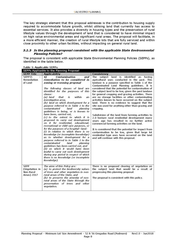
Ordinary Meeting of Council
25 October 2021
RP-1 - PLANNING PROPOSALS - LEP18/0004 AND LEP18/0009 - GREGADOO ROAD AND TALLOWOOD CRESCENT - AMENDMENT TO LAND ZONING AND MINIMUM LOT SIZE REQUIREMENTS OF THE WAGGA WAGGA LOCAL ENVIRONMENTAL PLAN 2010 AND AMENDMENT TO WAGGA WAGGA DEVELOPMENT CONTROL PLAN 2010
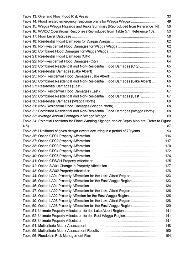
(1) LEP18/0004 - Application to amend Wagga Wagga Local Environmental Plan 2010.. 3
(2) LEP18/0009 - Application to amend Wagga Wagga Local Environmental Plan 2010 36
(3) LEP18/0004 and LEP18/0009 - Addendum to Planning Proposal............................ 111
(4) Amendment to Development Control Plan 2010........................................................ 128
(5) Gateway Determination & Alteration.......................................................................... 132
(6) Preliminary Consultation Submissions....................................................................... 135
(7) Initial Consultation Submissions................................................................................. 165
(8) Additional Information - Servicing Plans.................................................................... 188
(9) Final Consultation Submissions................................................................................. 196
(10) Final Consultation Submission Summary and Response.......................................... 342
(11) Community Workshop Summaries............................................................................. 369
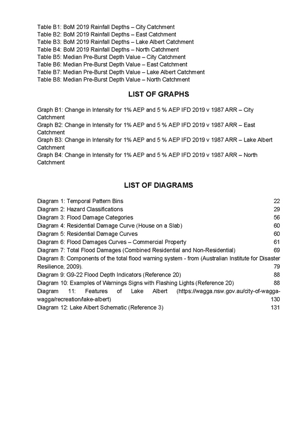
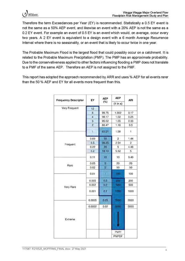
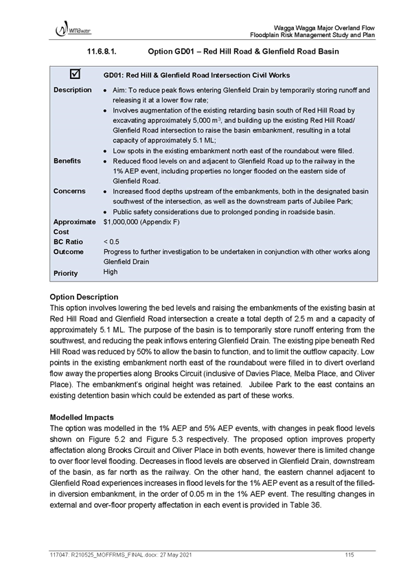
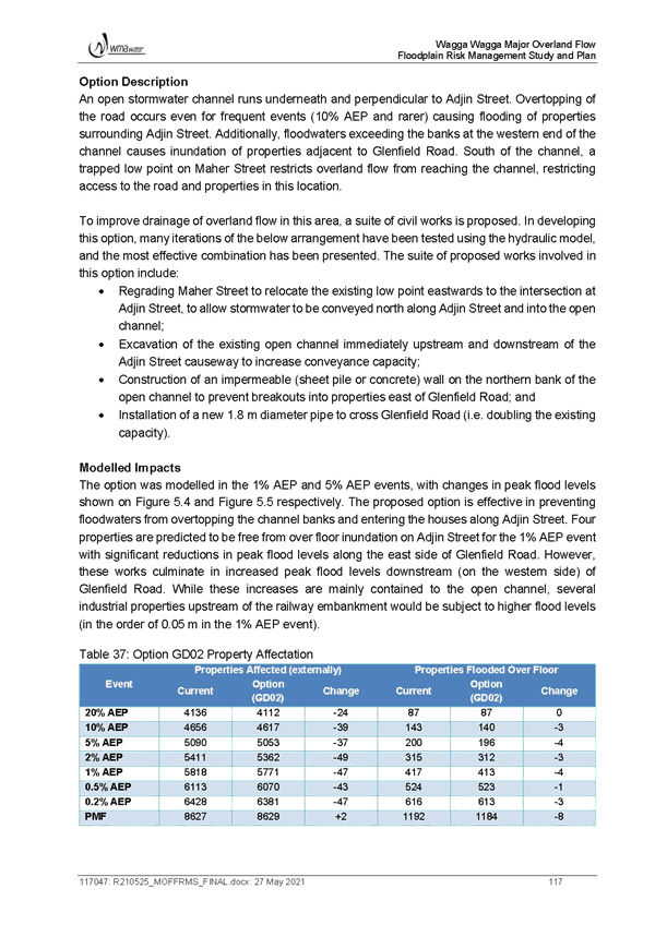
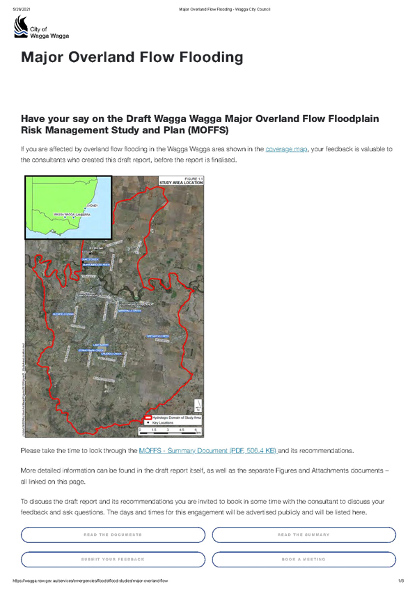
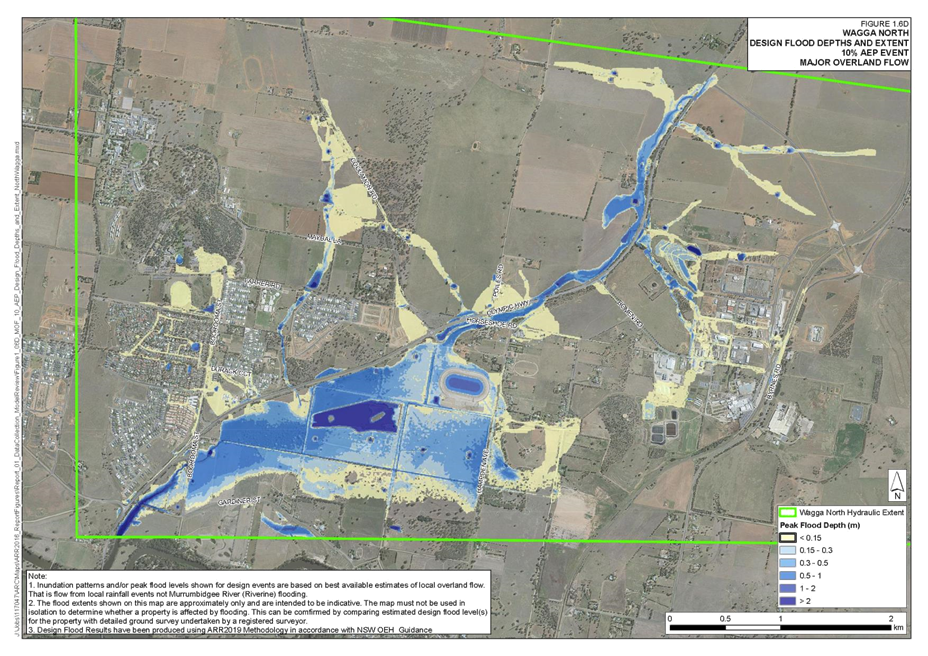
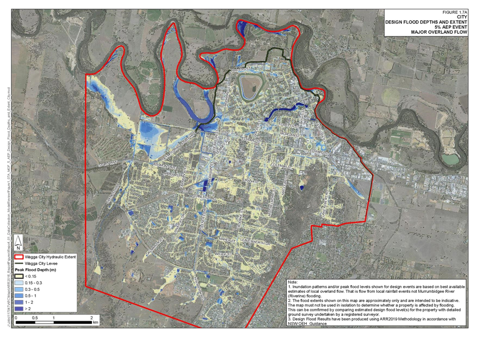
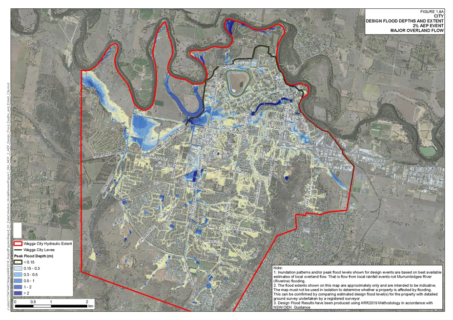
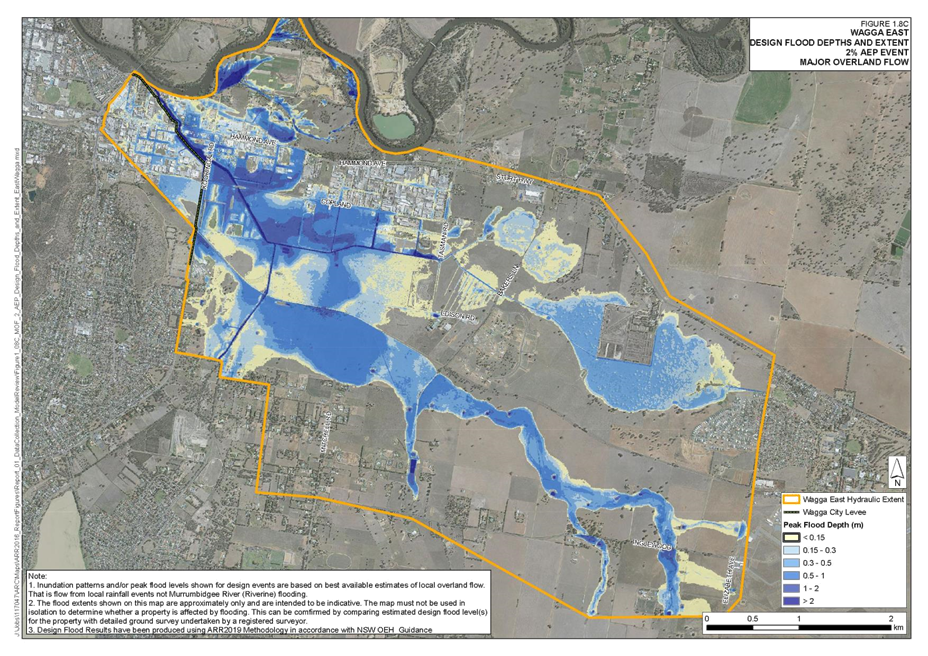
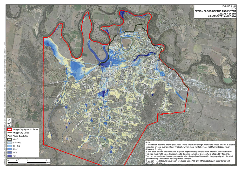
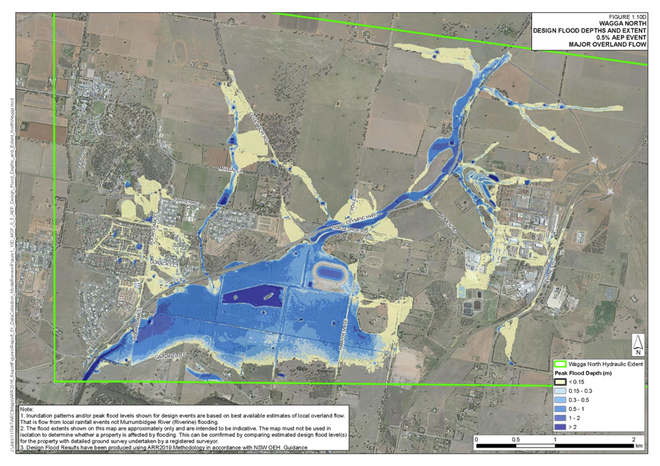
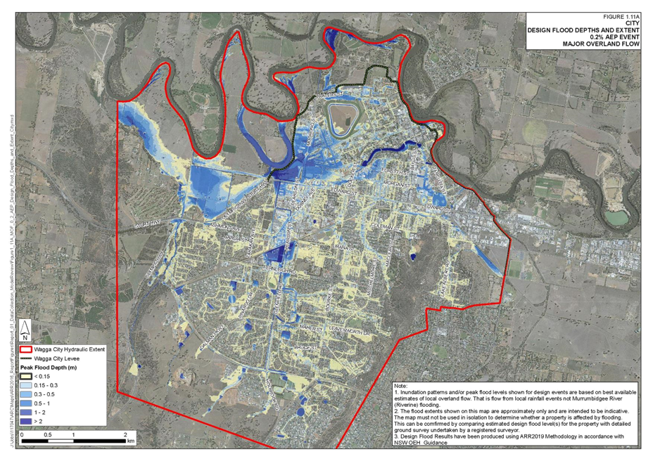
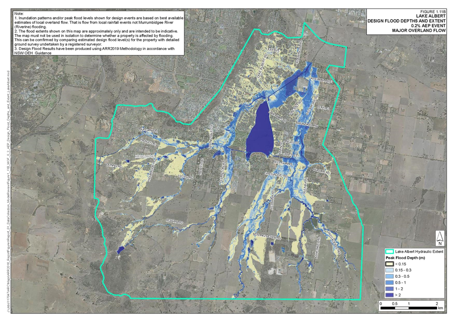
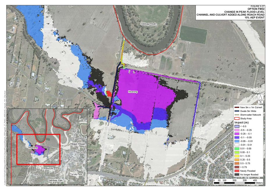
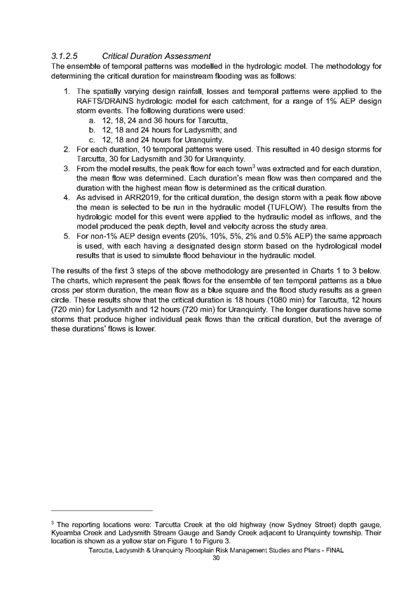
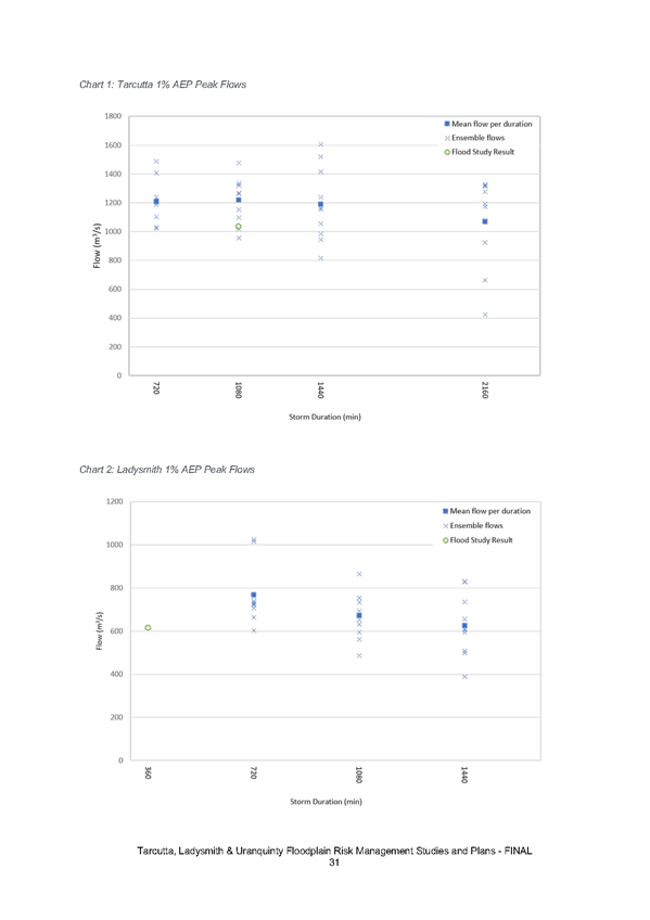
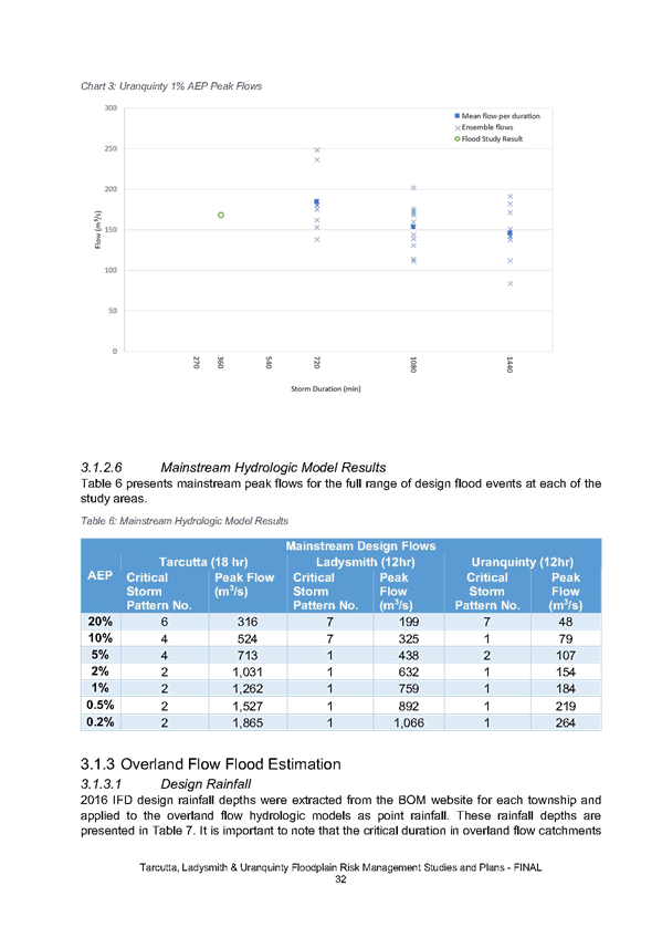
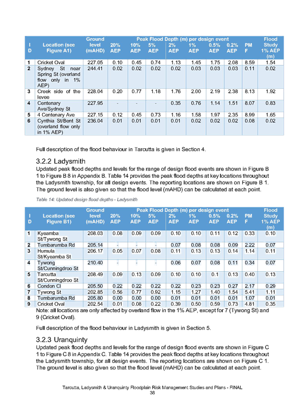
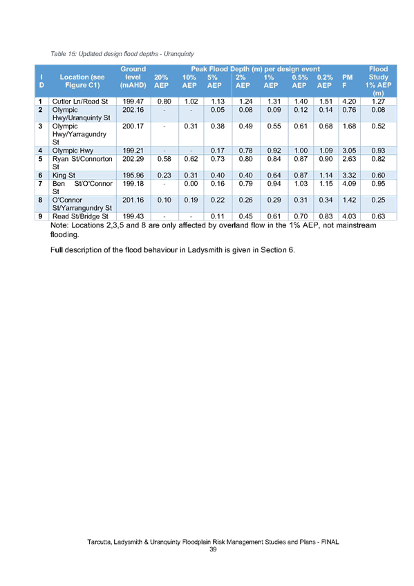
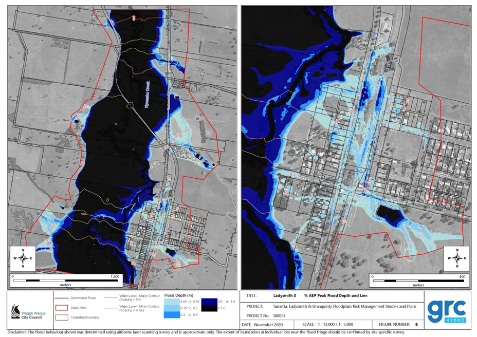
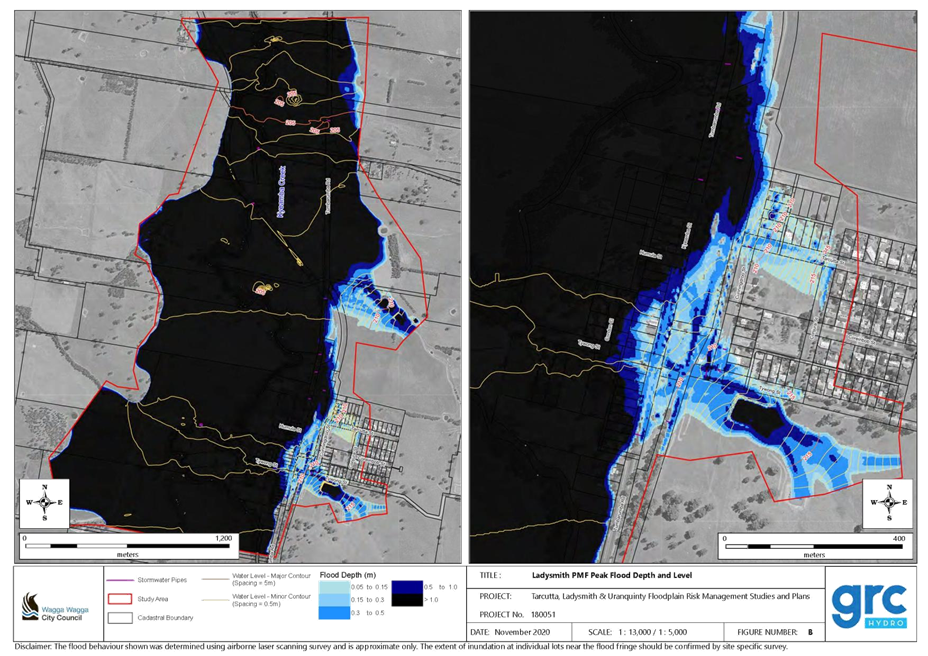
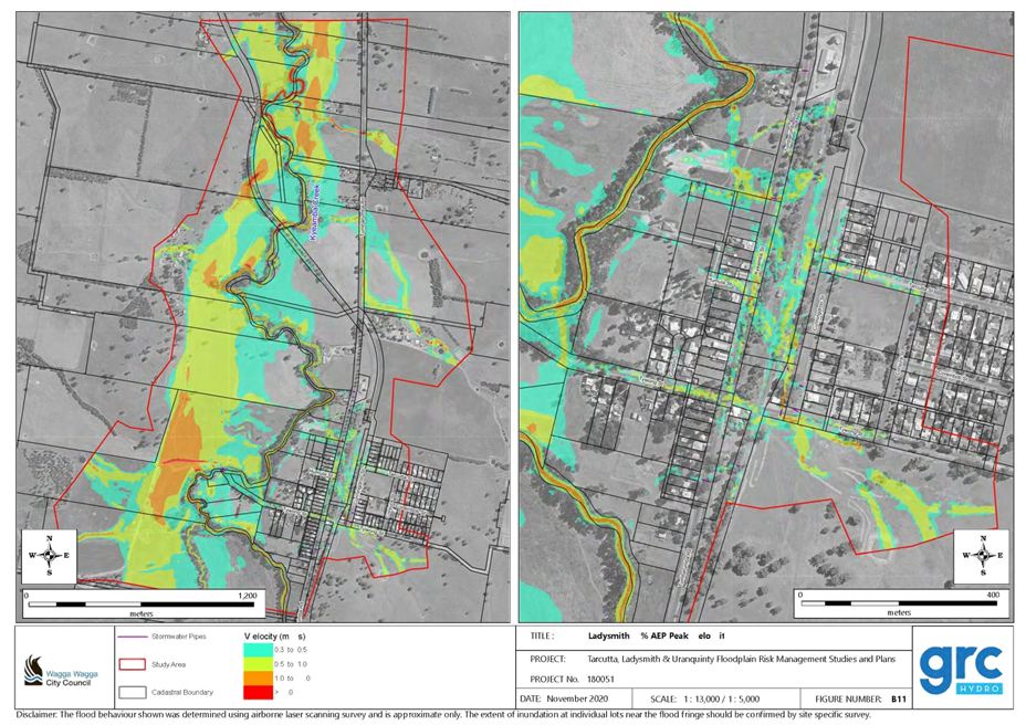
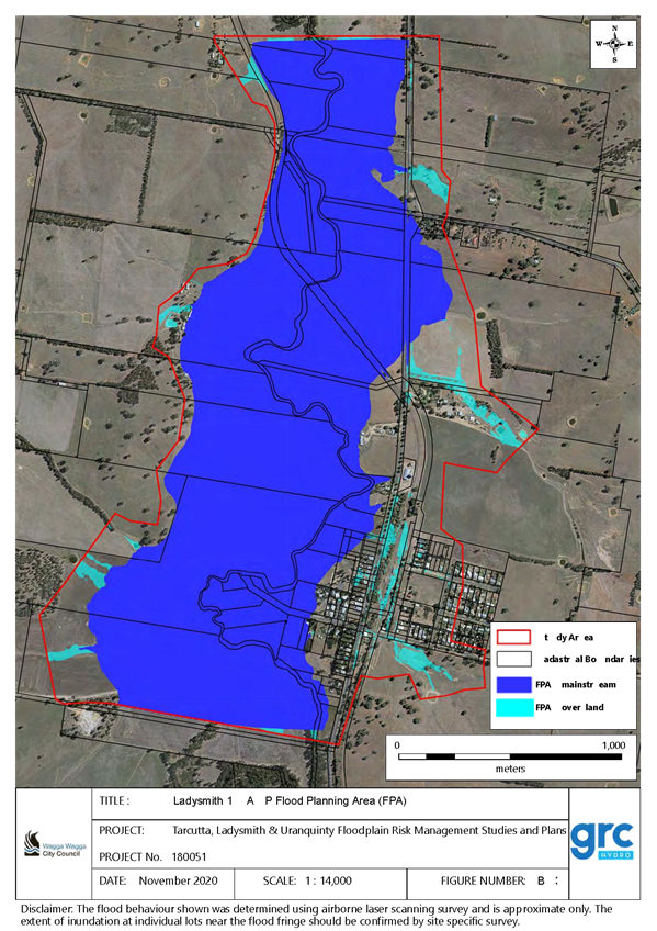
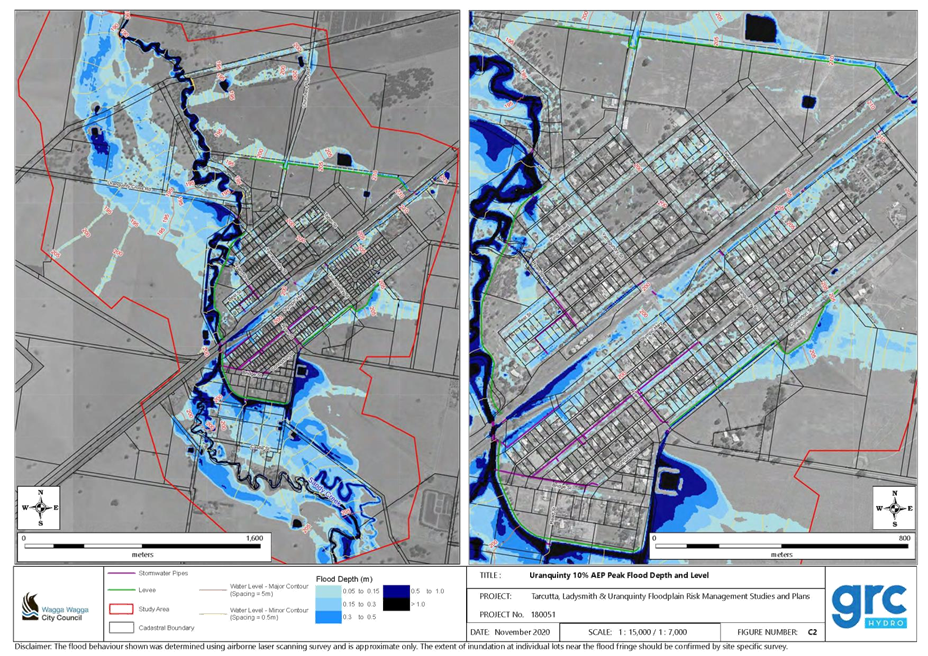
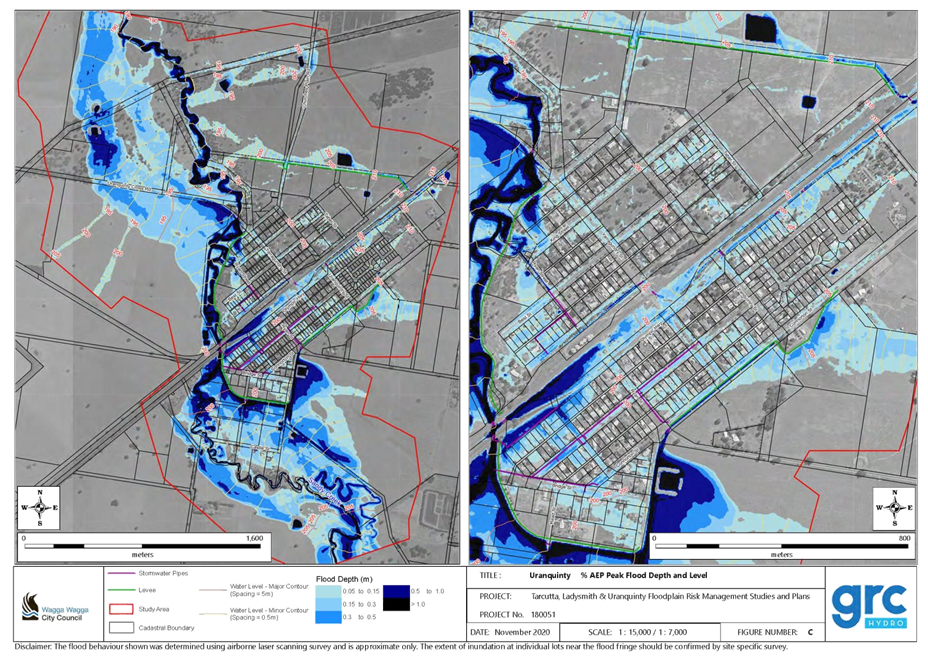
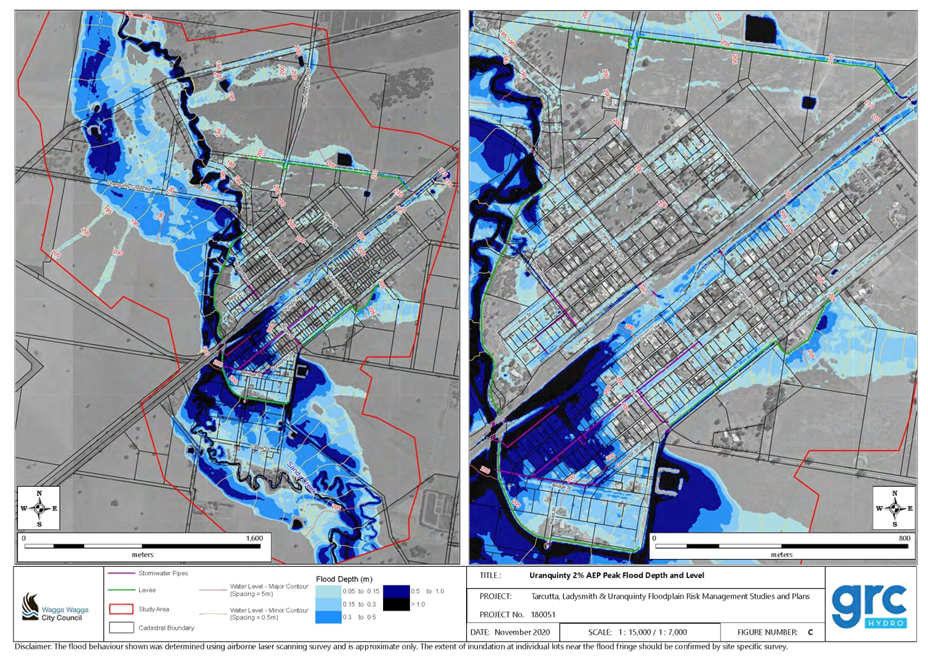
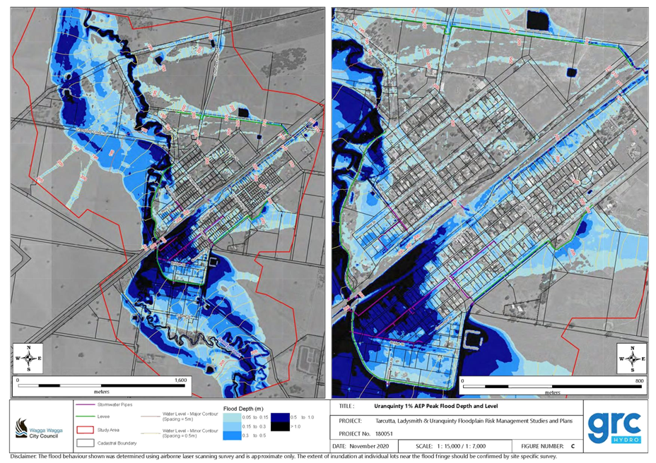
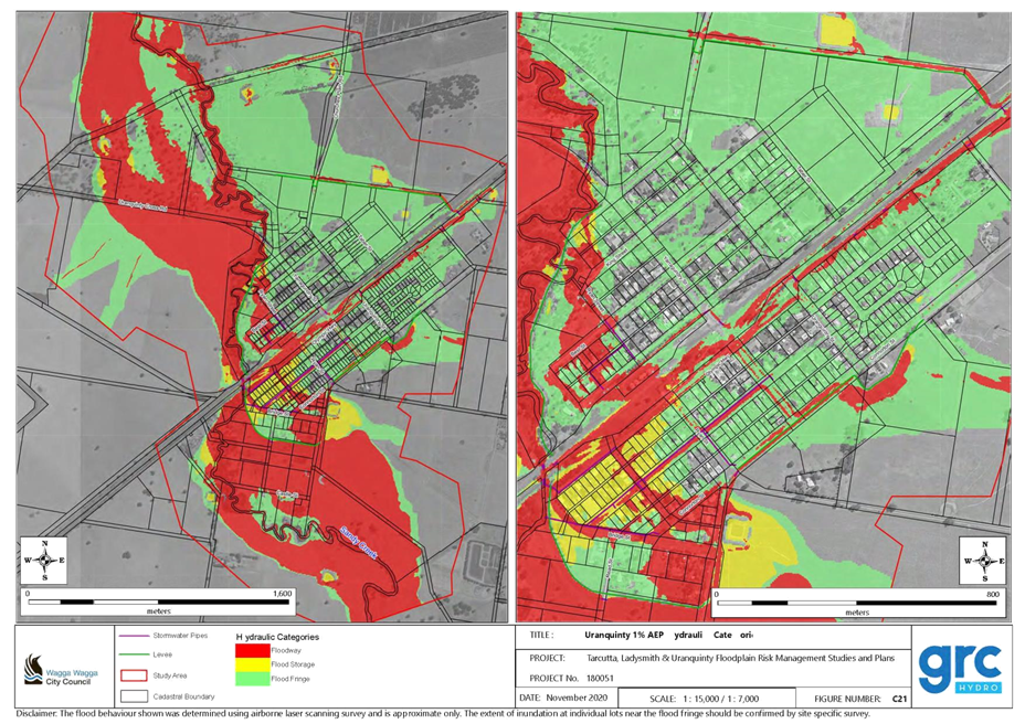
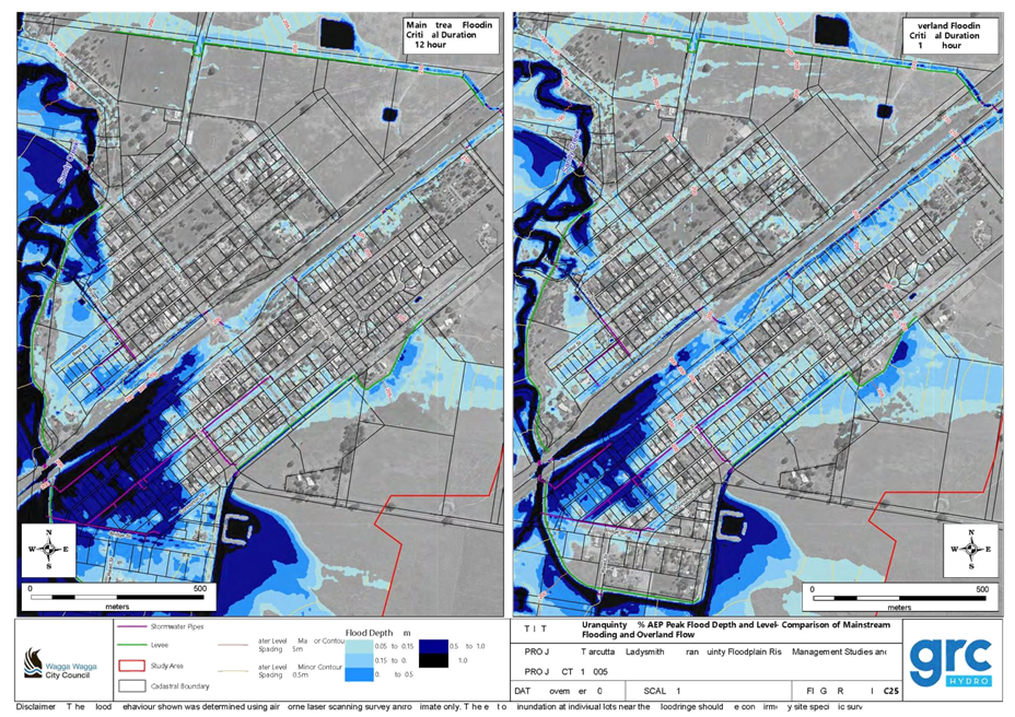
RP-3 - WAGGA WAGGA MAJOR OVERLAND FLOW FLOODPLAIN STUDY (MOFFS) & THE TARCUTTA, LADYSMITH AND URANQUINTY FLOODPLAIN STUDY (VOFFS)
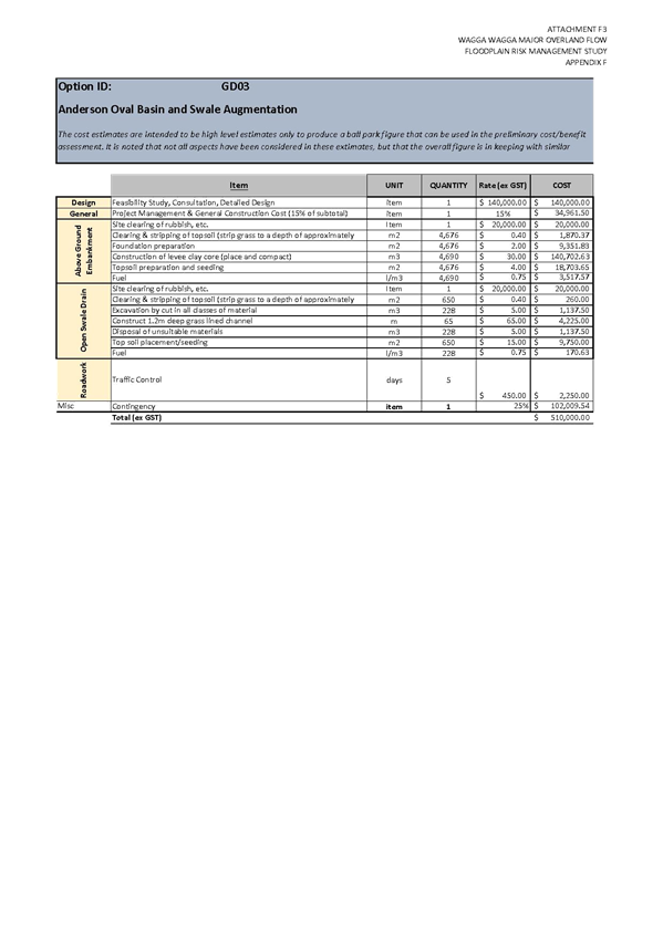
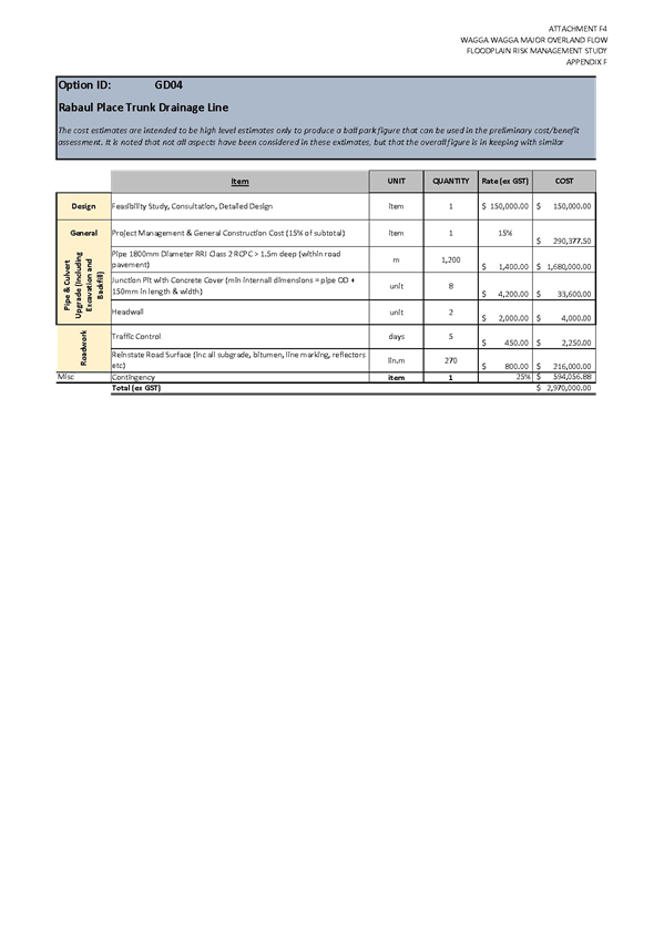
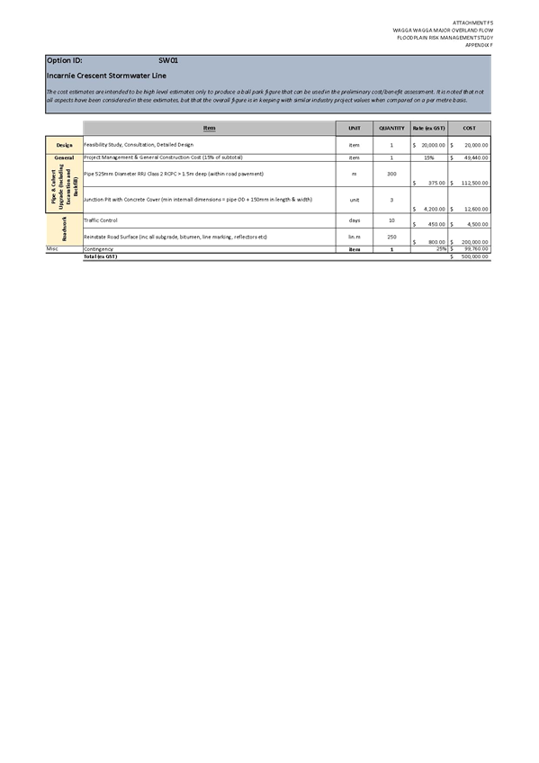
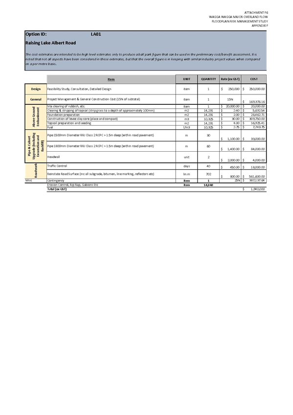
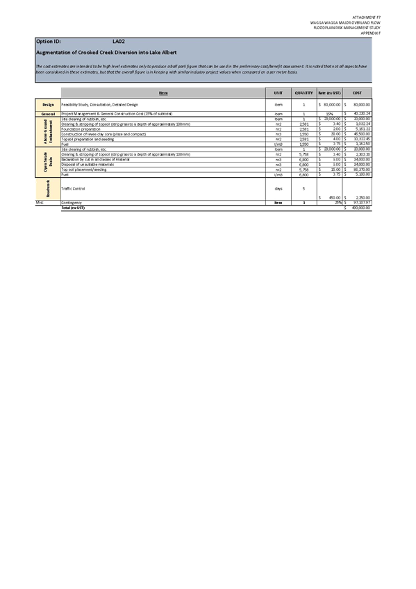
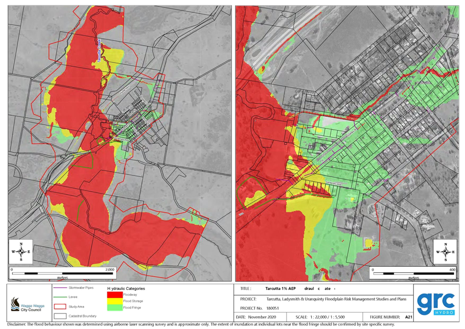
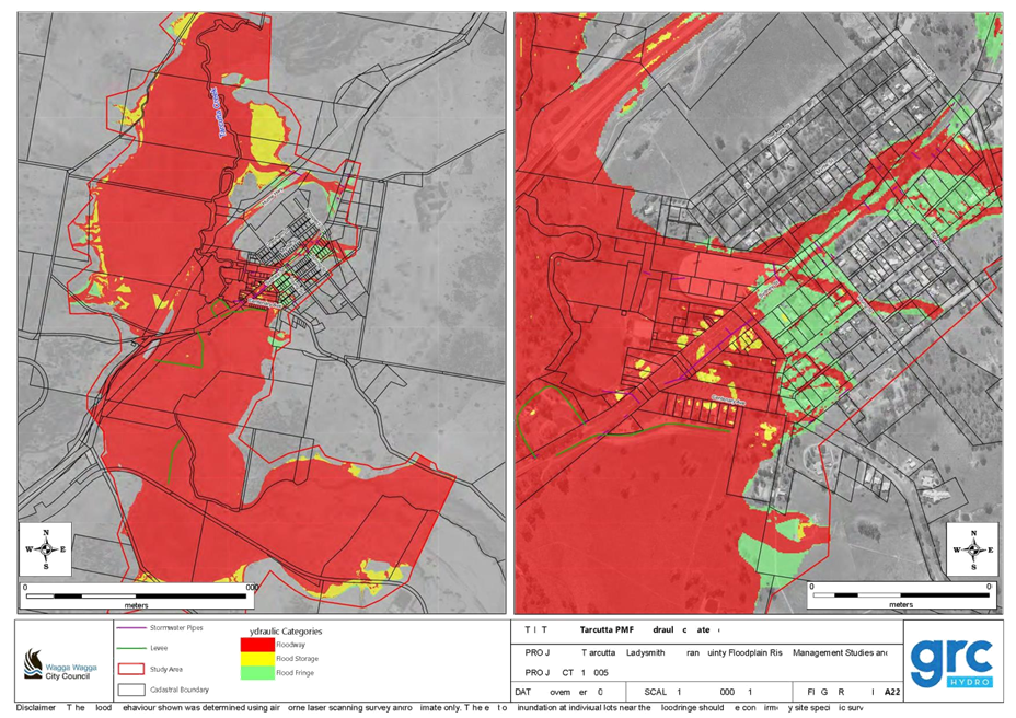
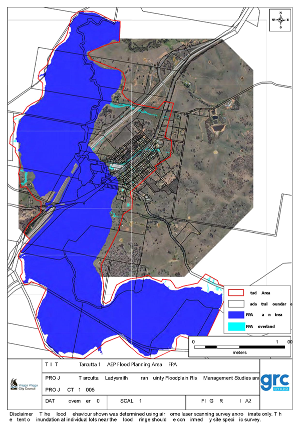
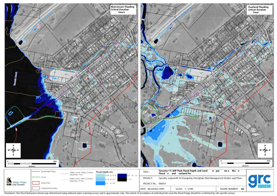
(1) MOFFS - Final Report 2021....................................................................................... 389
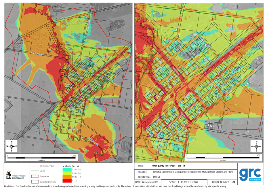
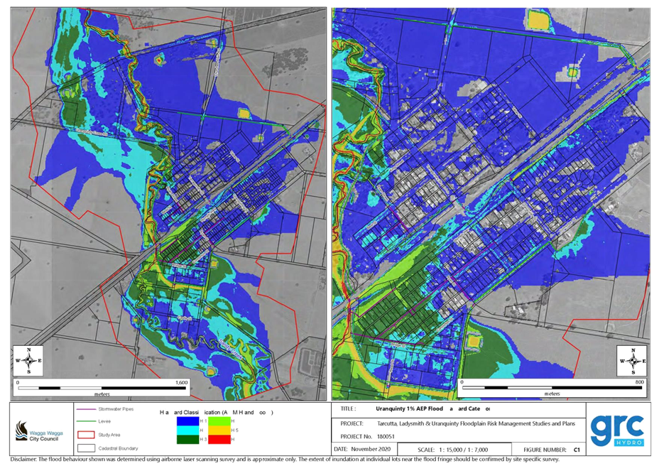
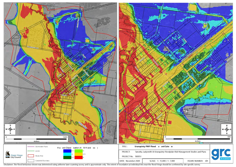
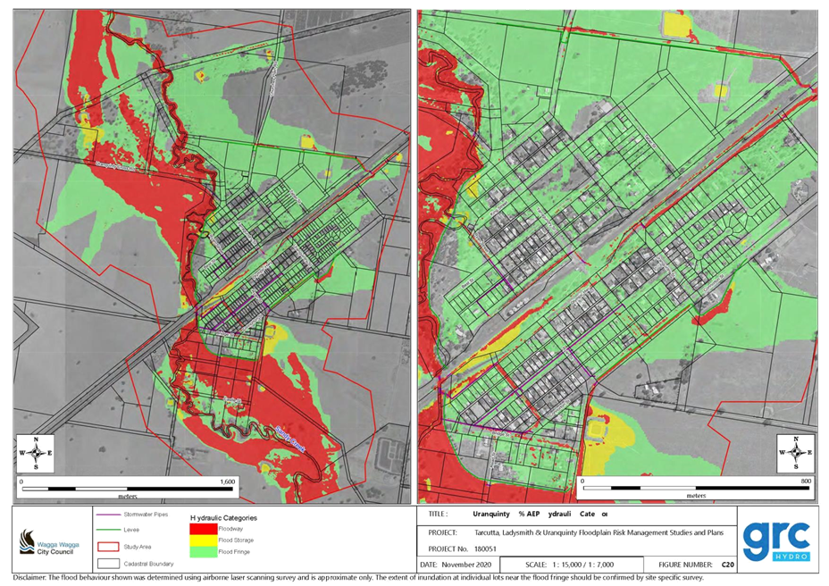
(2) MOFFS - Final Figures 2021...................................................................................... 648
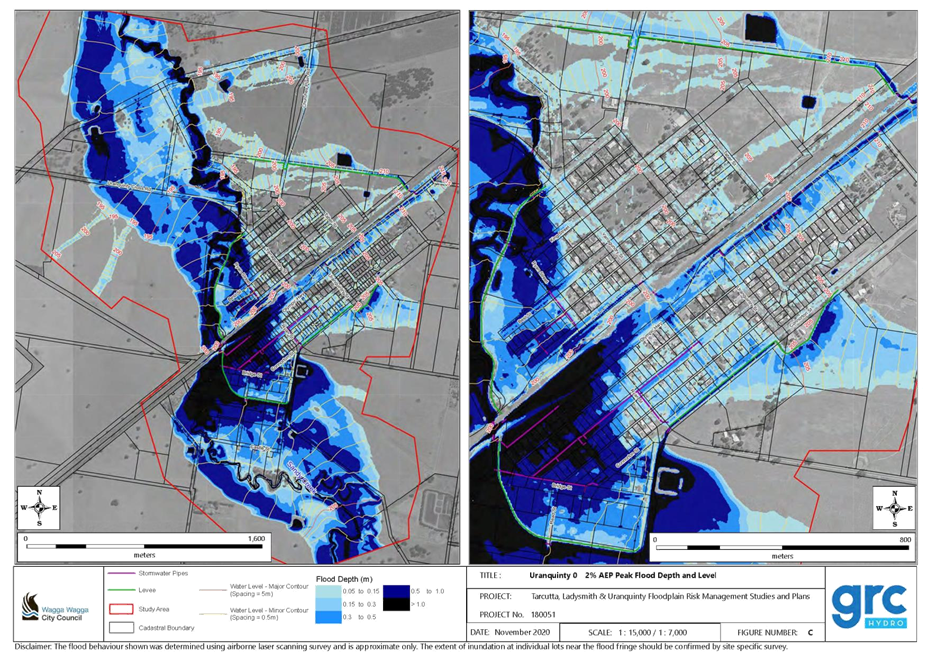
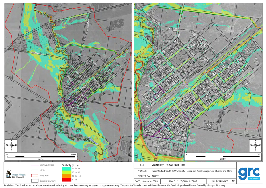
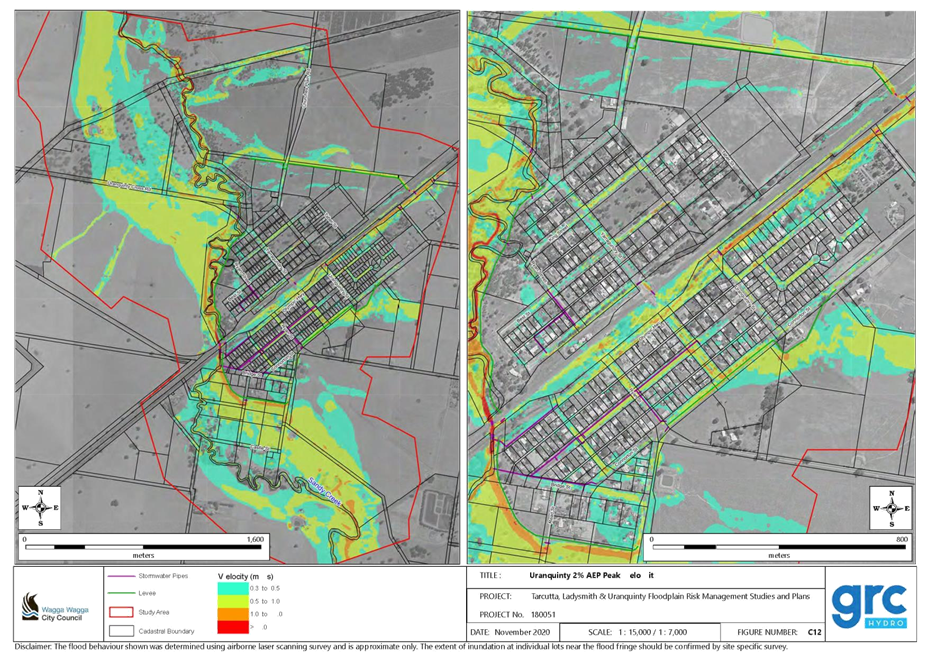
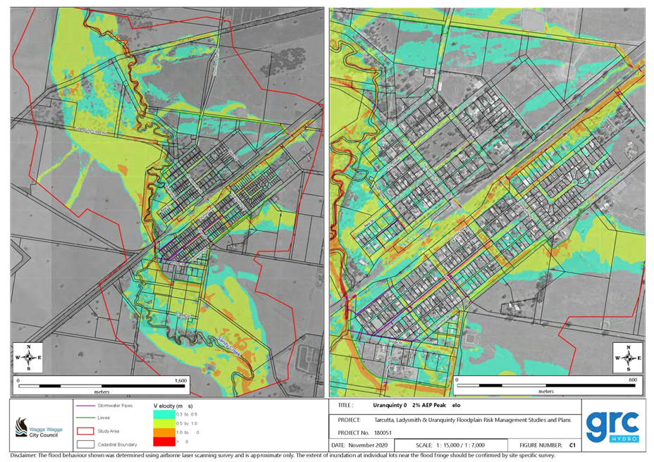
(3) VOFFS - Final Report 2021........................................................................................ 767
(4) VOFFS - Appendix A.................................................................................................. 924
(5) VOFFS - Appendix B.................................................................................................. 949
(6) VOFFS - Appendix C.................................................................................................. 975
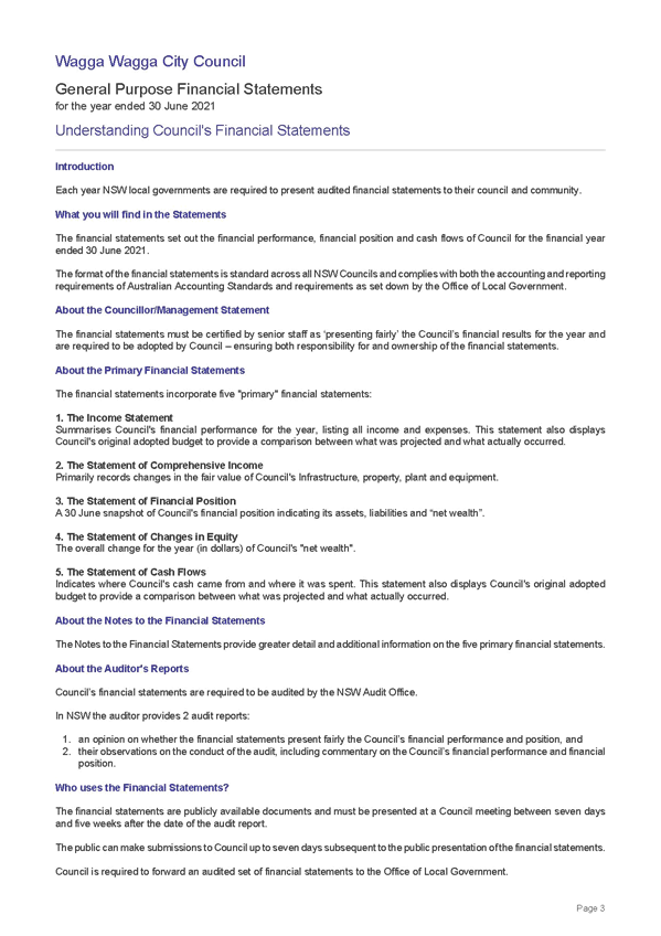
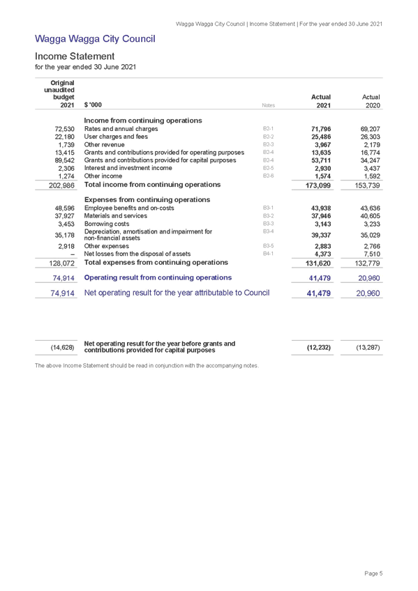
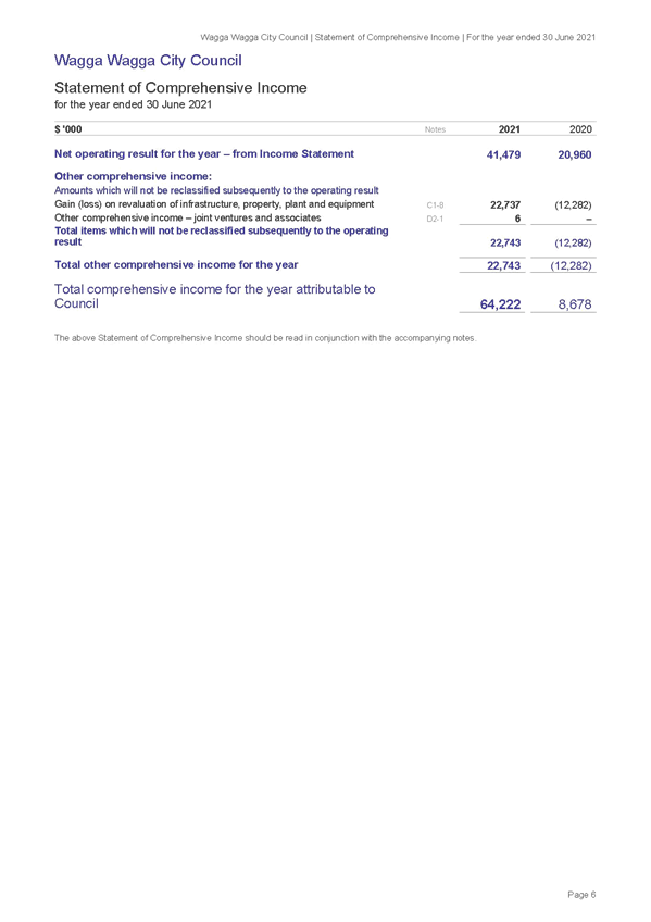
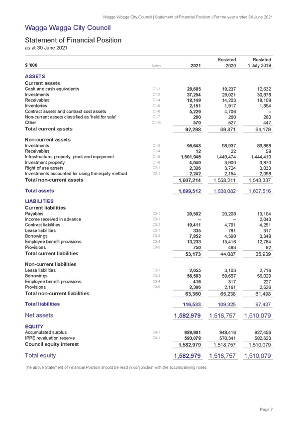
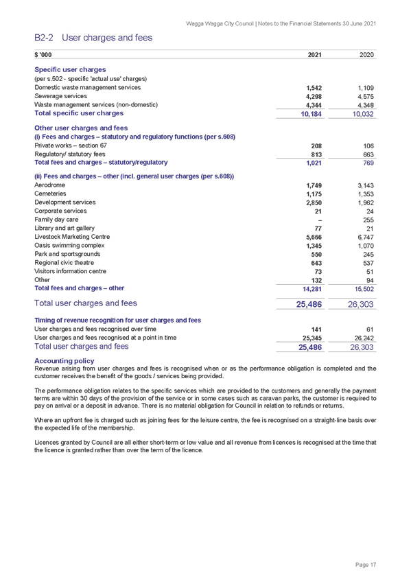
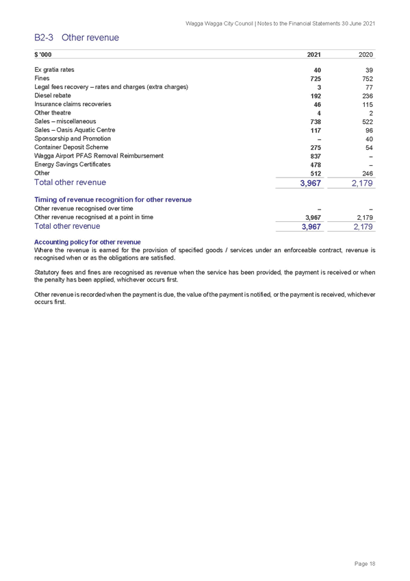
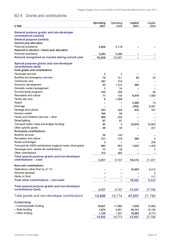
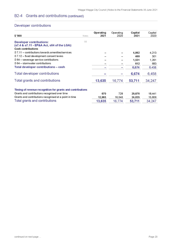
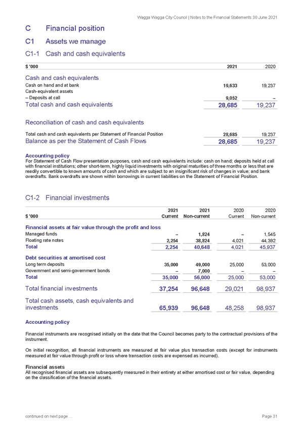
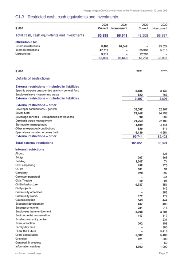
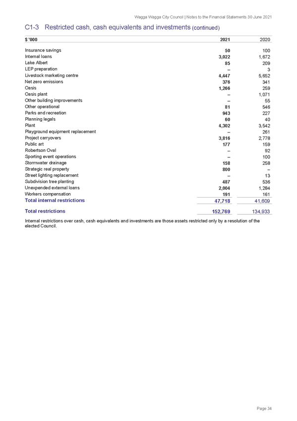
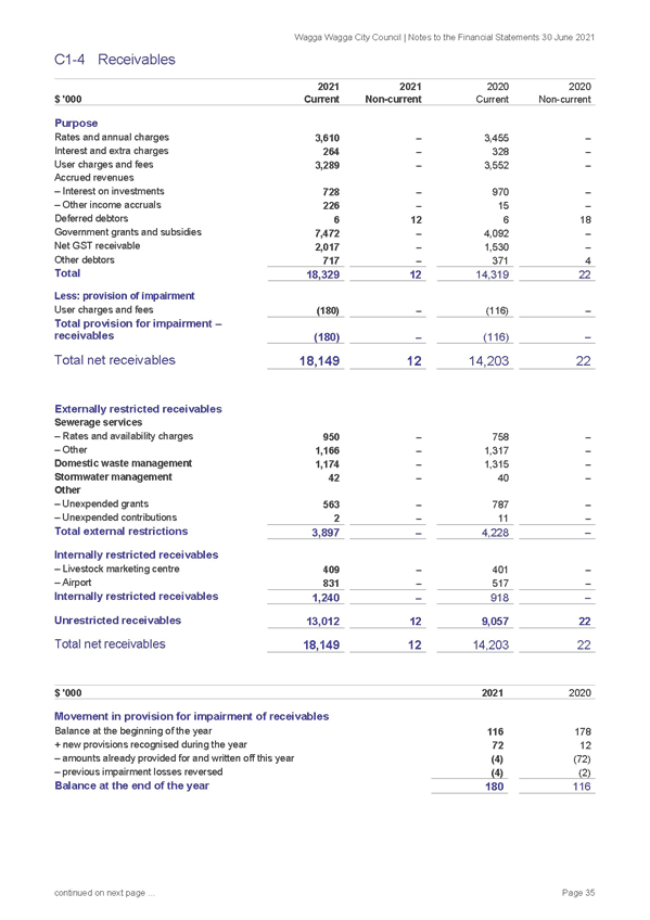
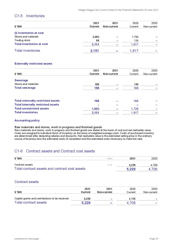
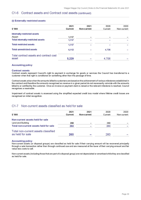
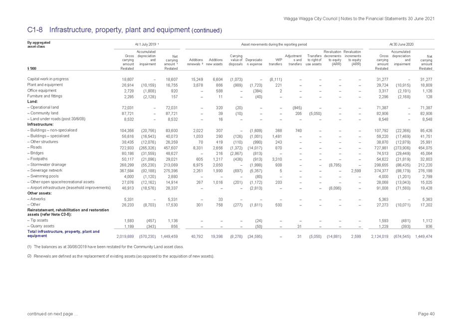
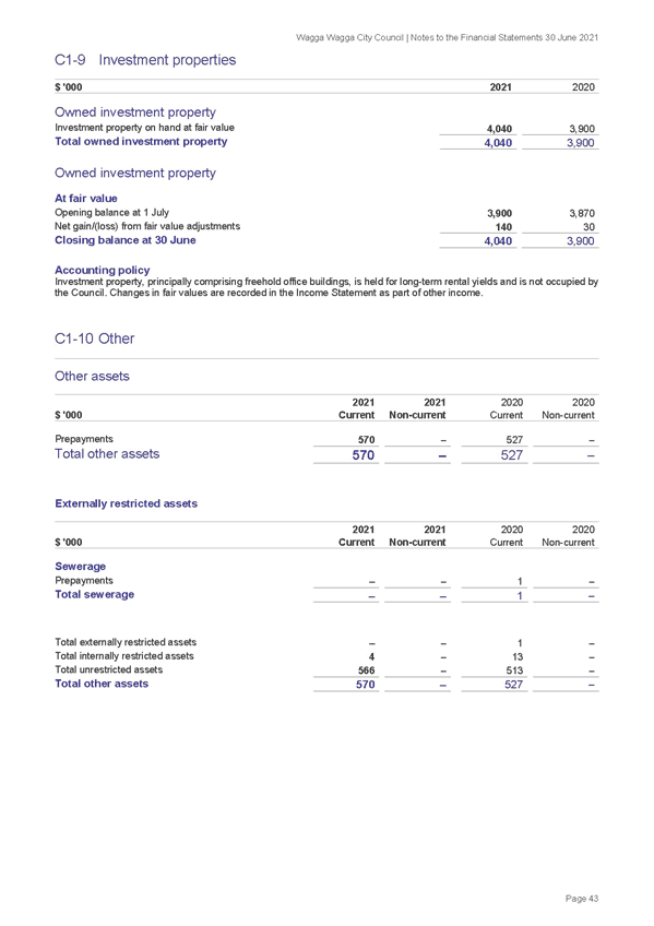
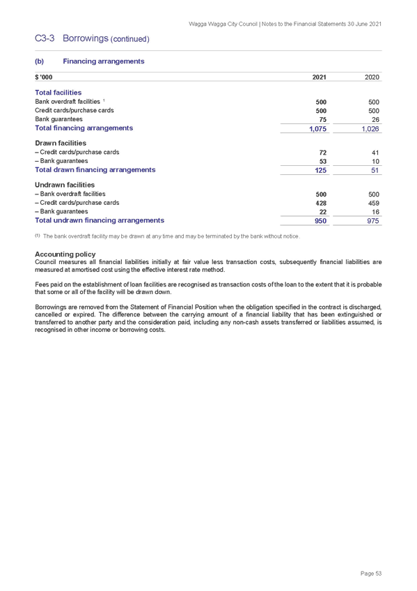
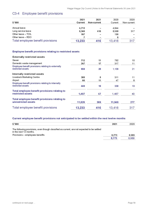
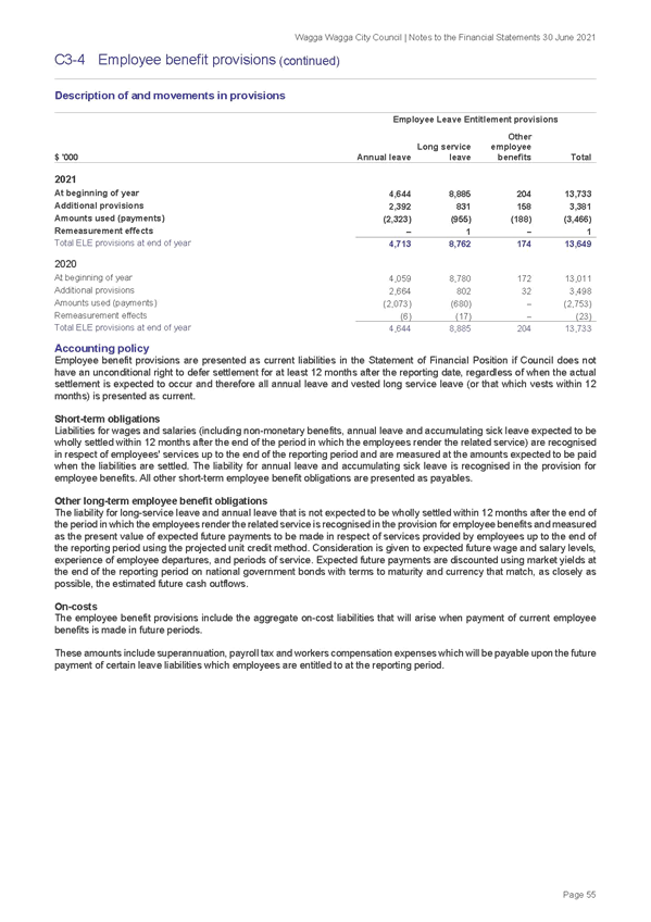
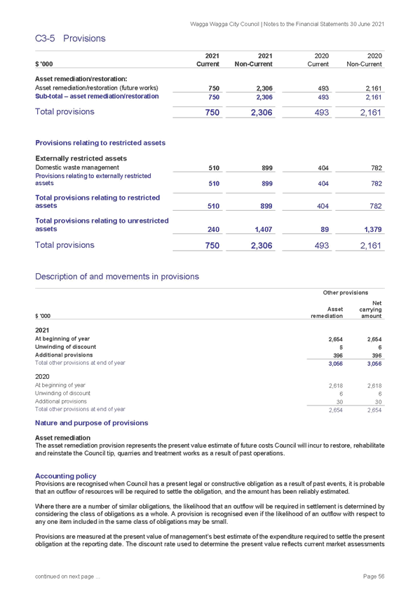
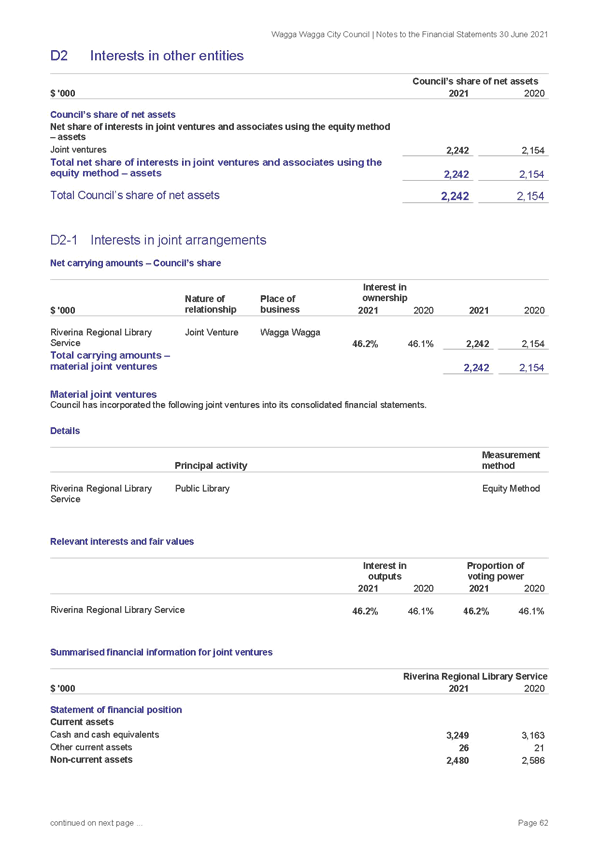
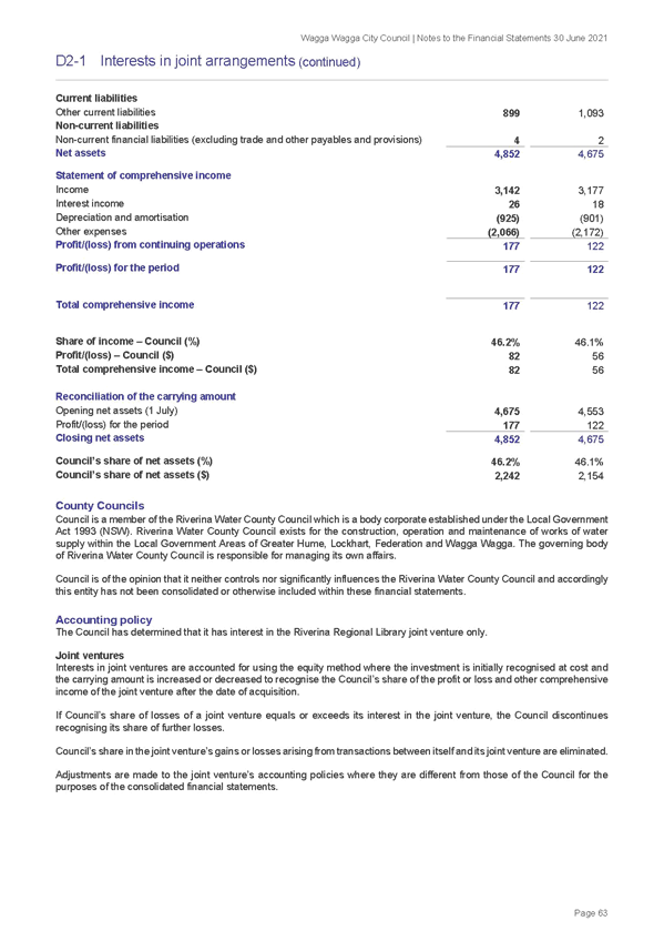
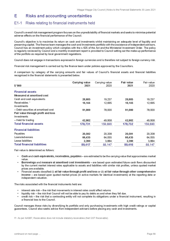
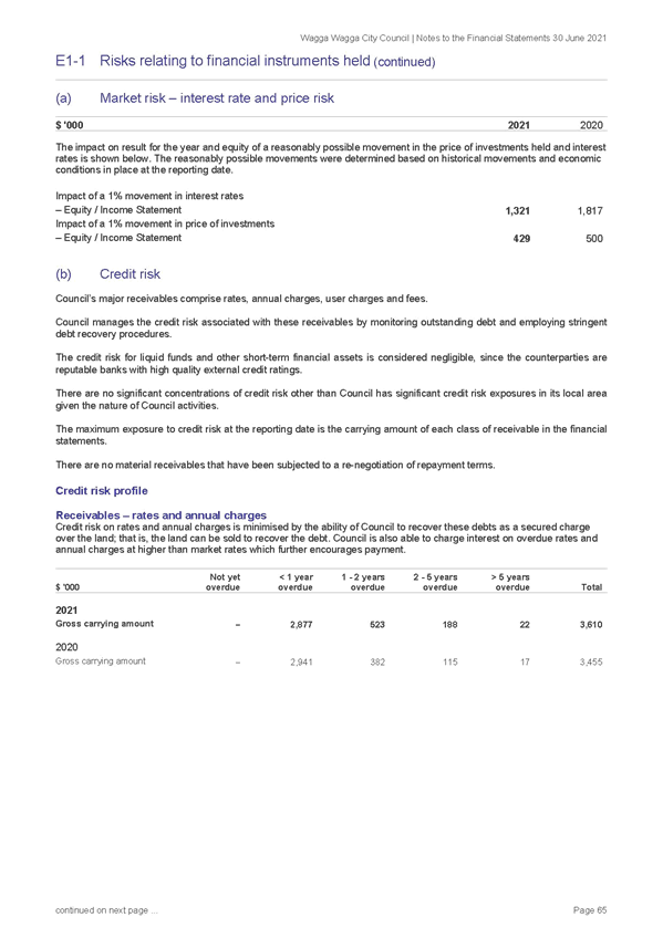
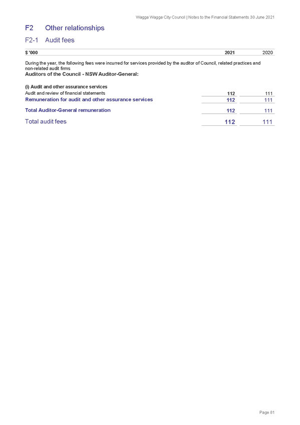
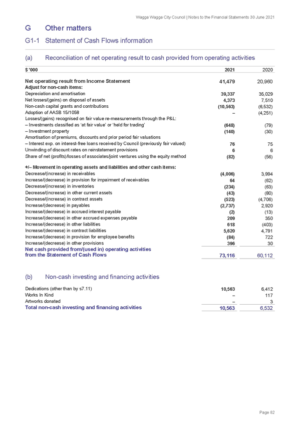
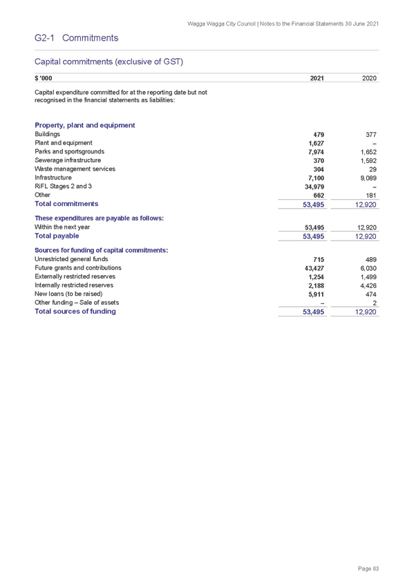
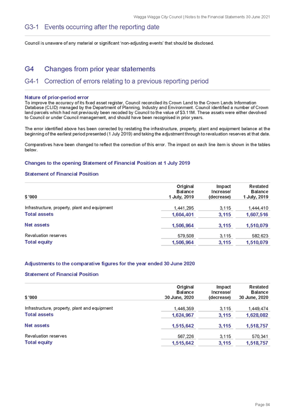
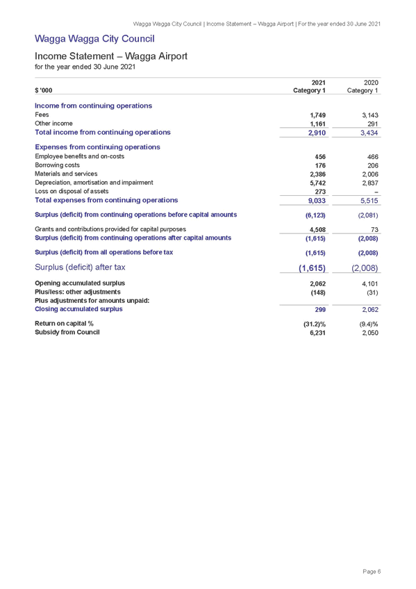
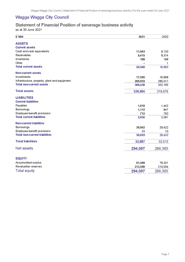
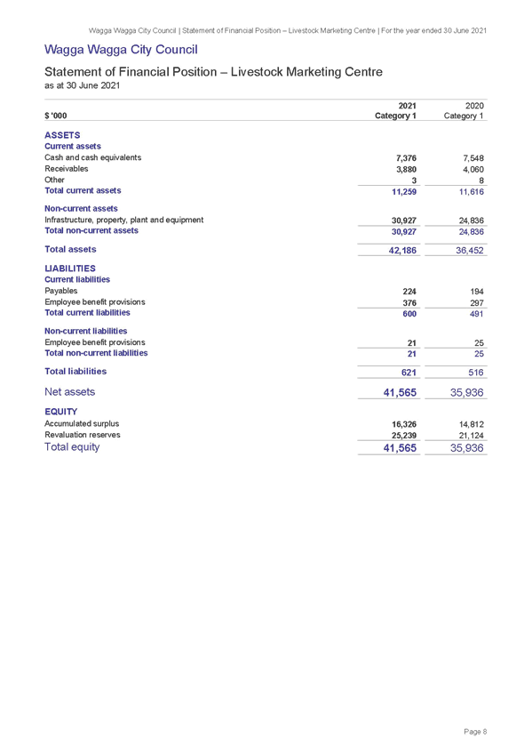
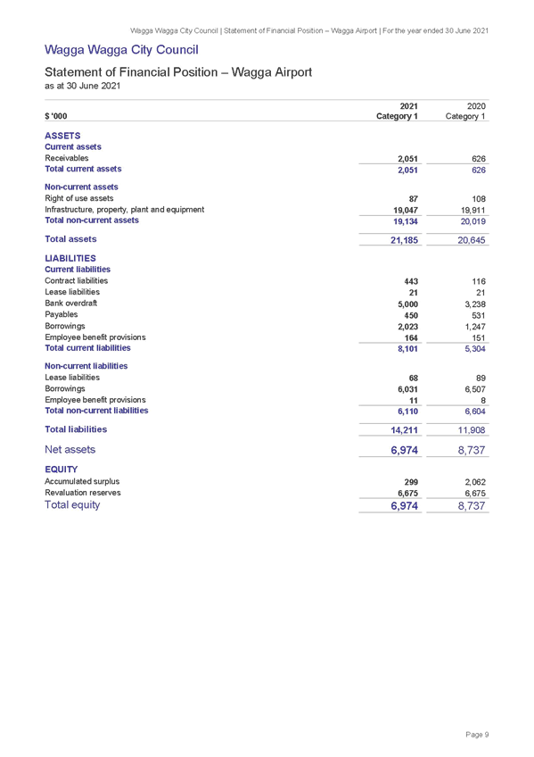
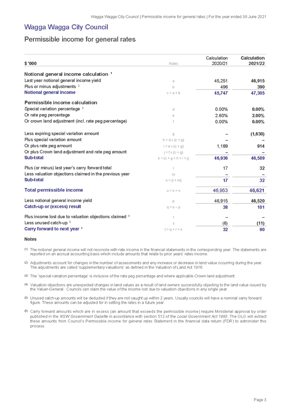
RP-4 - ANNUAL FINANCIAL STATEMENTS 2020/21
(1) 2020/21 Draft Annual Financial Statements............................................................. 1000
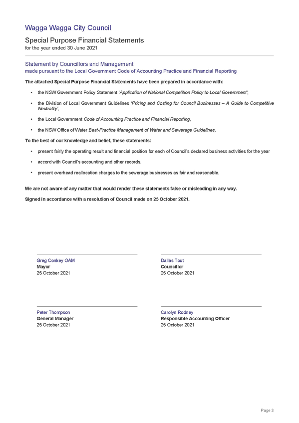
(2) 2020/21 General Purpose Financial Statements - Statement by Councillors and Management 1114
(3) 2020/21 Special Purpose Financial Statements - Statement by Councillors and Management 1115
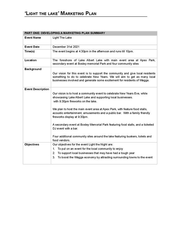
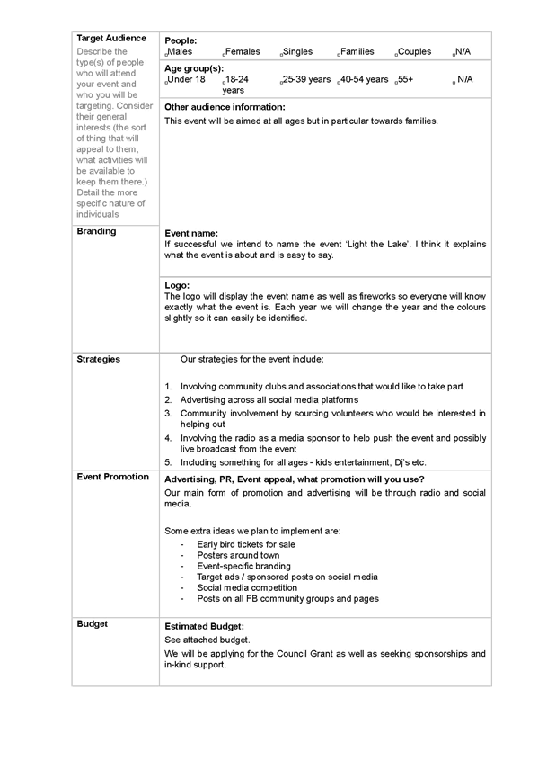
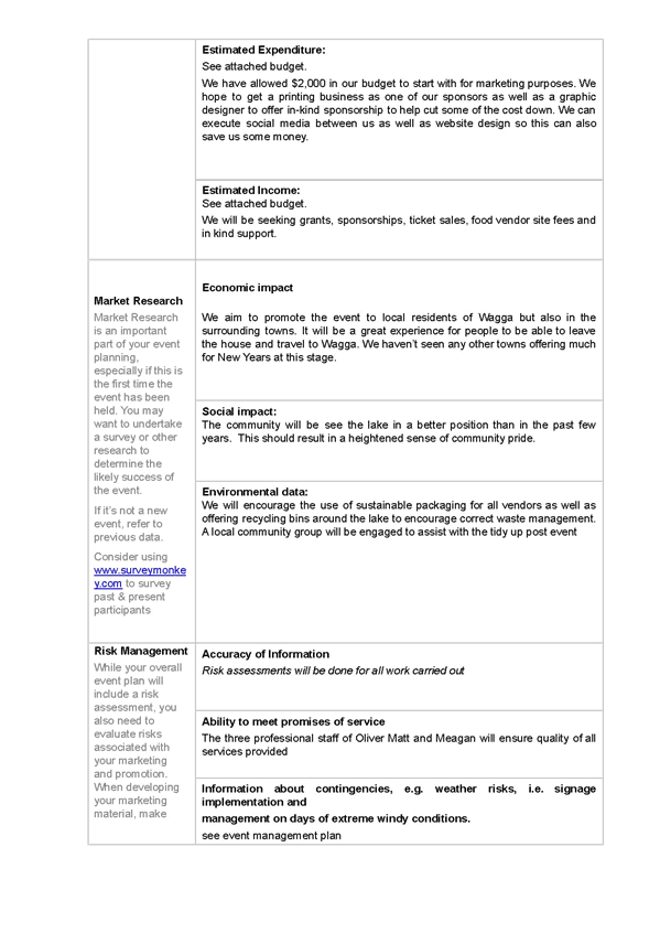
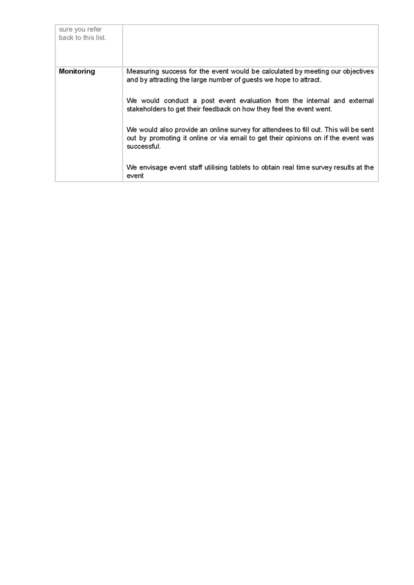
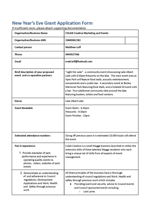
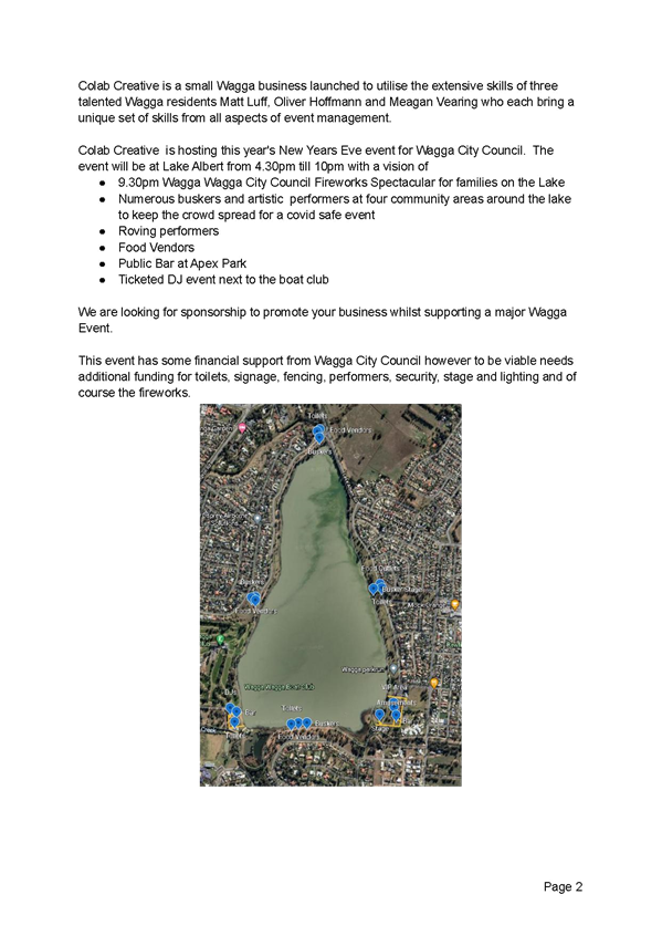
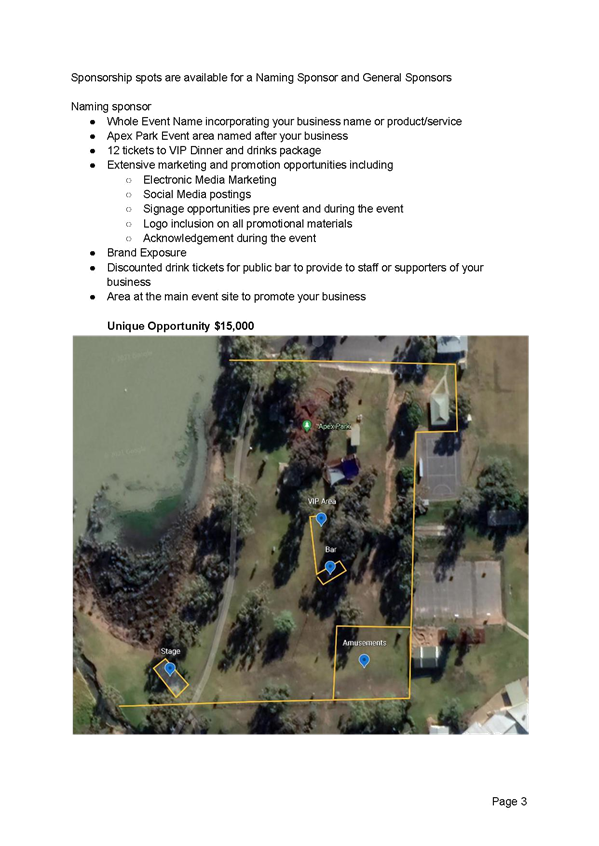
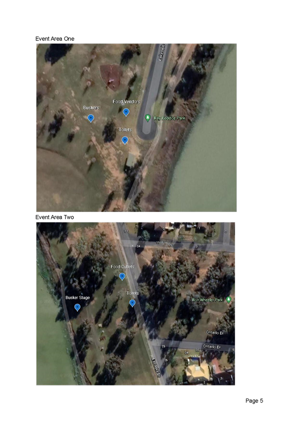
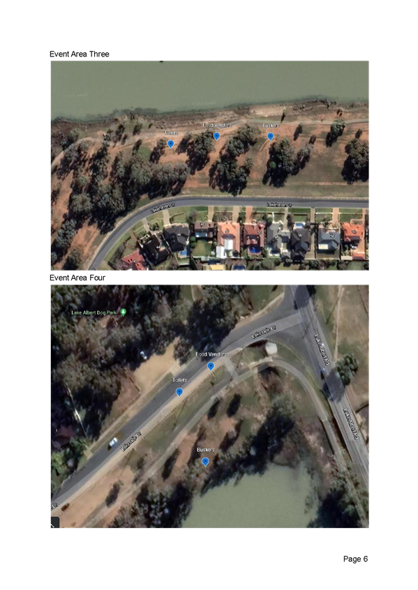
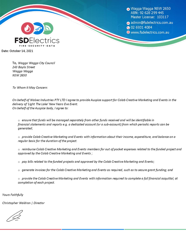
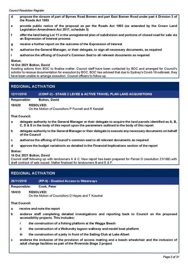
RP-5 - NEW YEAR'S EVE 2021 & 2022
(2) Light the Lake Event Management Plan.................................................................. 1116
(3) Light the Lake Marketing Plan.................................................................................. 1128
(4) Light the Lake Risk Assessment Management........................................................ 1132
(5) Light the Lake Covid Safety Plan............................................................................. 1137
(6) Light the Lake NYE EOI Submission........................................................................ 1146
(7) Light the Lake Sponsorship Form............................................................................ 1151
(11) Auspice Letter of Support......................................................................................... 1157
RP-10 - RESOLUTIONS AND NOTICES OF MOTIONS REGISTERS
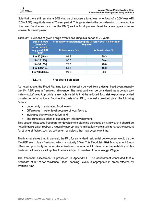
(1) Active Resolution Register - October 2021.............................................................. 1159
(2) Active Notice of Motions - October 2021.................................................................. 1190
(3) Completed Resolutions - October 2021................................................................... 1195
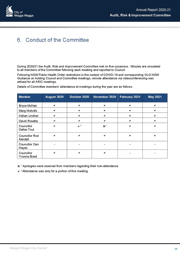
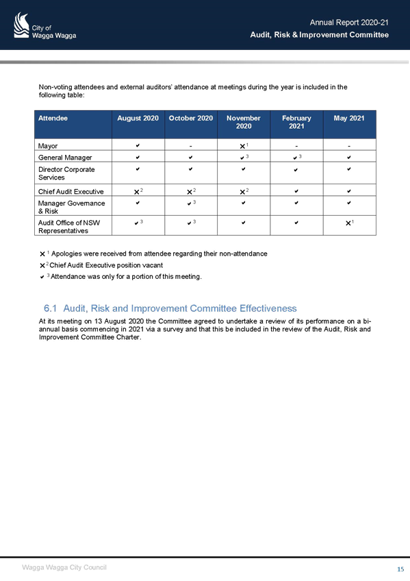
M-1 - CONFIRMATION OF MINUTES AUDIT, RISK AND IMPROVEMENT COMMITTEE - 7 OCTOBER 2021 AND ARIC ANNUAL REPORT
(1) ARIC Annual Report 2020-21................................................................................... 1202
Report submitted to the Ordinary Meeting of Council on Monday 25 October 2021.
Attachments
Attachments
PART D
Section 9 Residential Development
Table of Contents
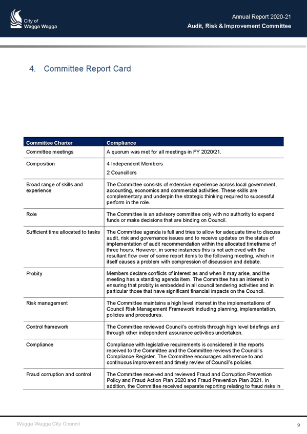
About Section 92
Principles for residential development2
9.1 Land Use Directions3
9.1.1 Central Wagga Wagga3
9.1.2 R1 Zone – established suburbs3
9.1.3 R3 (medium density) Zone in-fill potential4
9.1.4 R3 Zone – redevelopment areas8
9.1.5 R3 Zone – Staunton Estate9
9.2 Site context and layout16
9.2.1 Site layout16
9.2.2 Streetscape18
9.2.3 Corner lots and secondary facades18
9.2.4 Sloping sites19
9.3 Site area, building form and envelope20
9.3.1 Site area per dwelling20
9.3.2 Site cover21
9.3.3 R3 Zones - Minimum frontage23
9.3.4 Solar access23
9.3.5 Private open space24
9.3.6 ................................................................................................. Front setbacks24
9.3.7 Side and rear setbacks27
9.4 Design details28
9.4.1 Building elements28
9.4.2 Materials and finishes28
9.4.3 Privacy29
9.4.4 Garages, carports, sheds and driveways29
9.4.5 Site facilities. 30
9.4.6 Changing the landform – cut and fill31
9.5 R5 Large Lot Residential Zone - Intensification areas
9.5.1 Silverwood, Mitchel, Birch & Brunskill Road Precinct
9.5.2 Gregadoo & Tallowood Road Precinct
|
*** Sections not being amended have been removed for exhibition purposes ***
|
|
|
Explanatory Note(s):
|
|
|
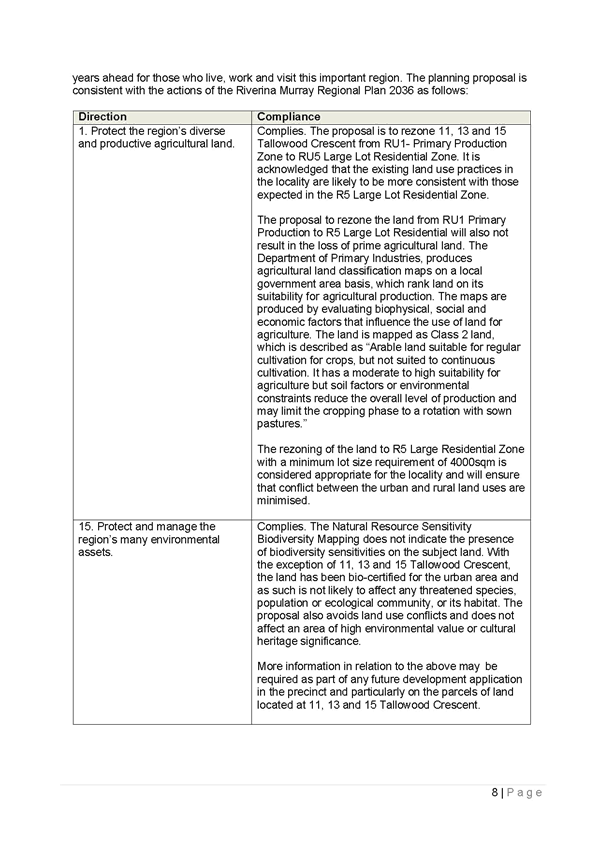
The R5 Large Lot Residential zone objectives seek to encourage residential housing in a rural setting while preserving, and minimising impacts on, environmentally sensitive locations and scenic quality, minimisation of conflict between land uses within this zone and land uses within adjoining zones and minimising clearing of native vegetation. |
|
|
9.5.1 R5 Zone - Silverwood, Mitchell, Birch & Brunskill Road Precinct [subject to separate amendment]
|
|
|
9.5.2 R5 Zone – Gregadoo & Tallowood Precinct |
|
|
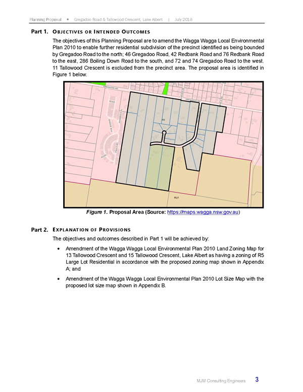
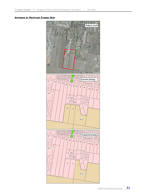
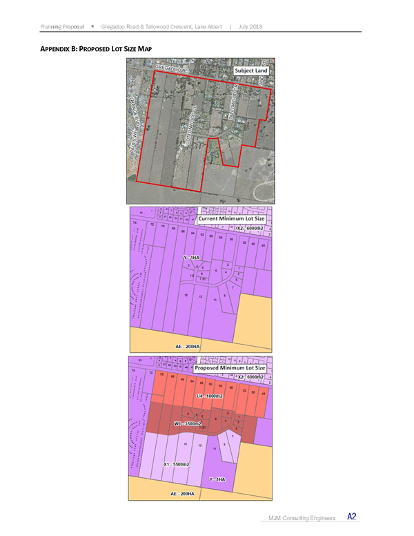
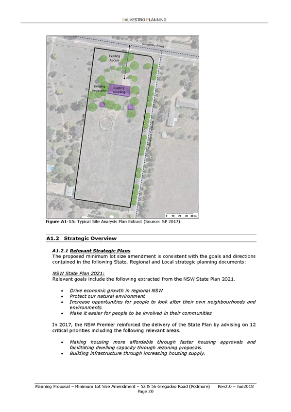
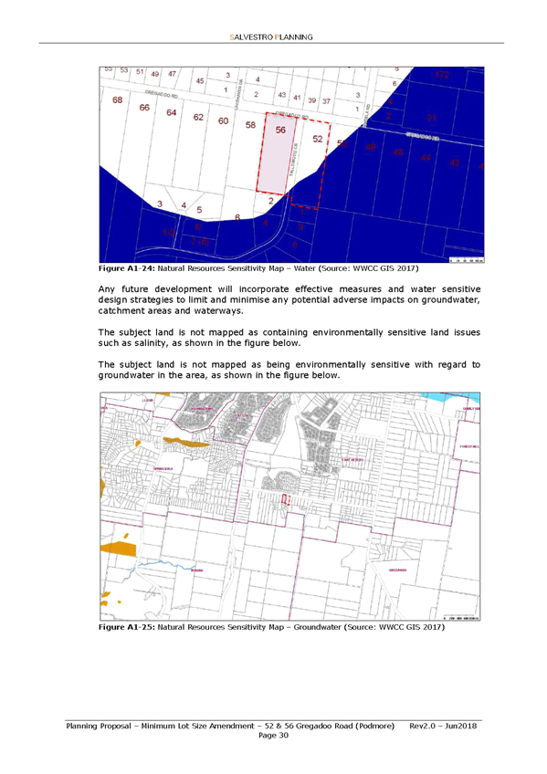
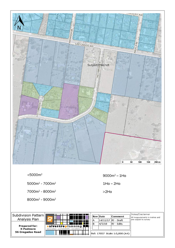
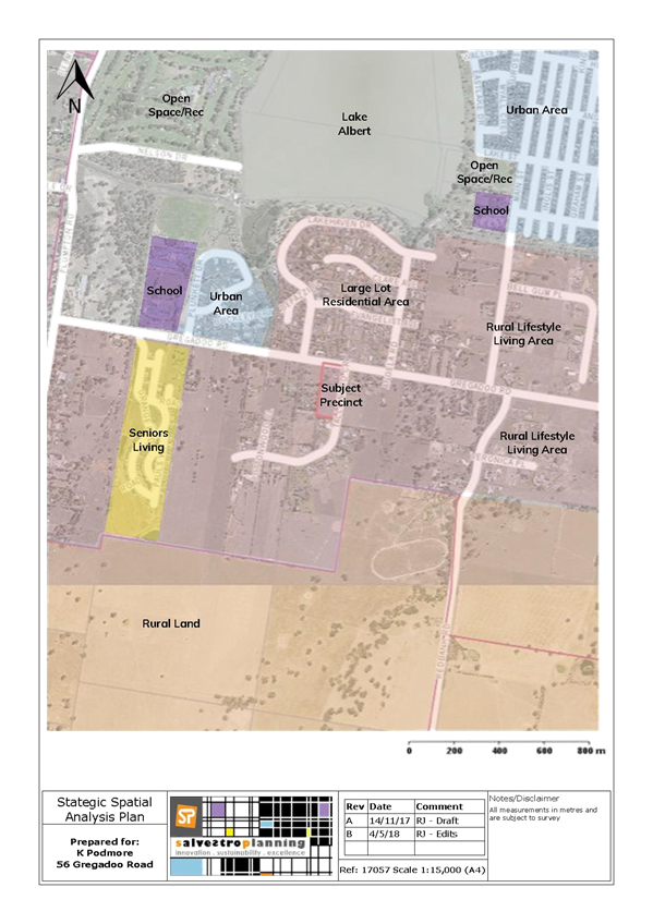
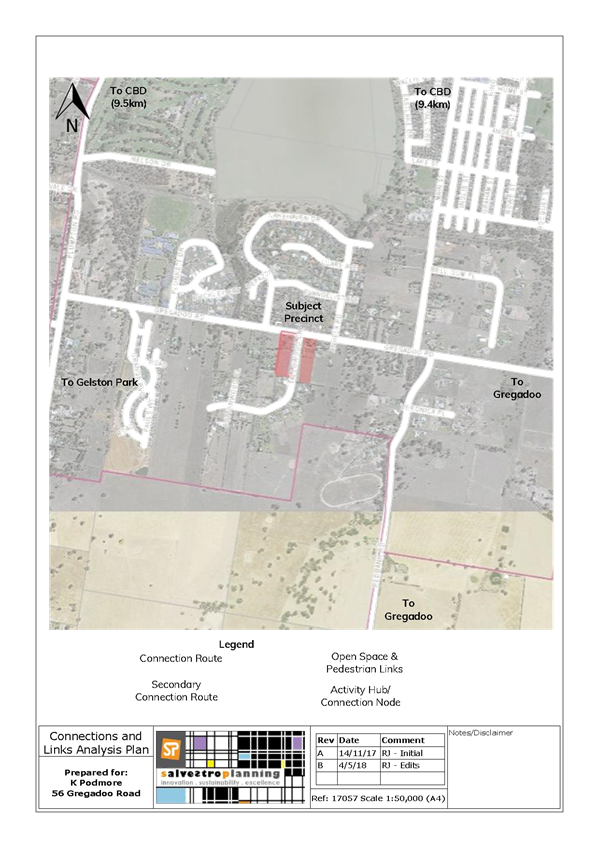
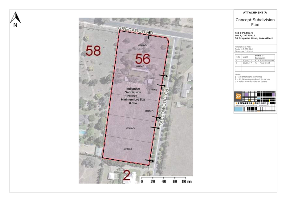
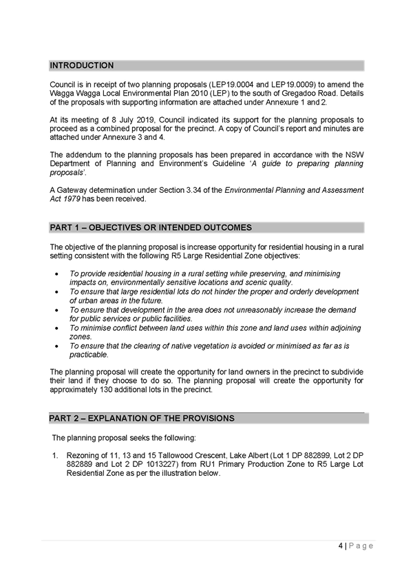
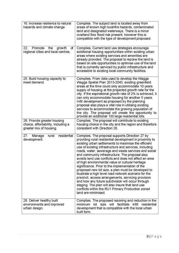
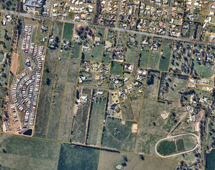
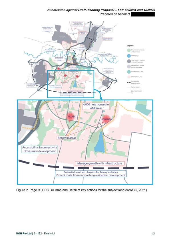
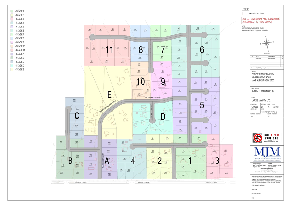
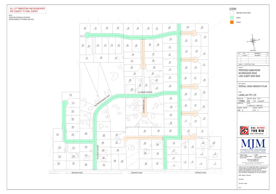
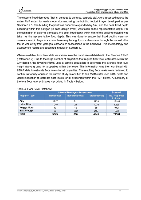
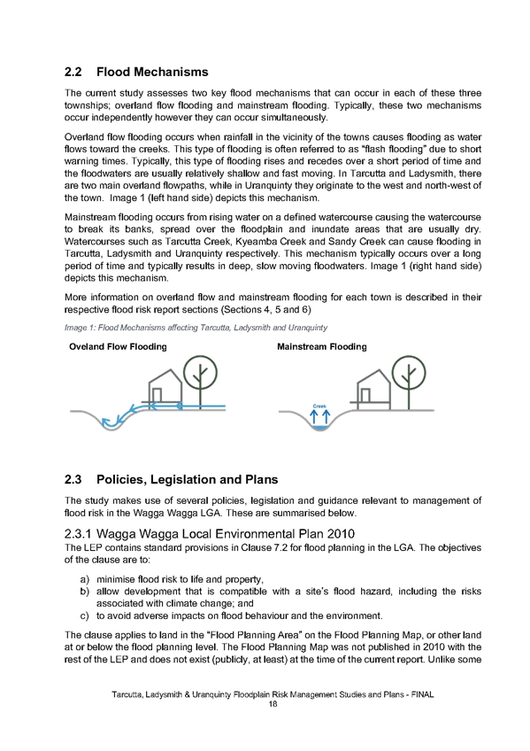
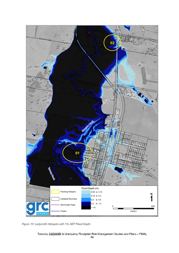
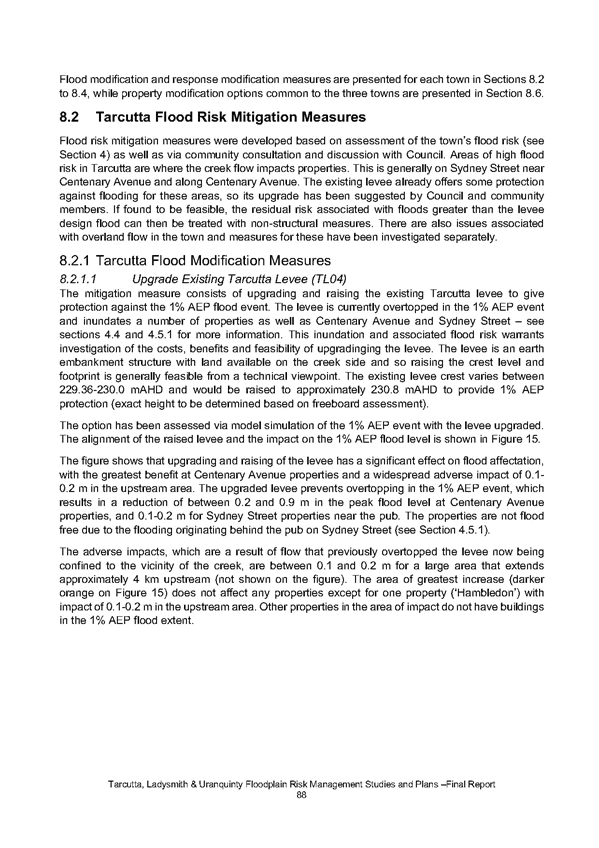
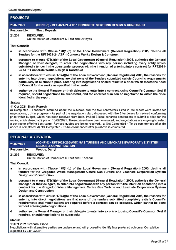
Where this Section Applies This section provides site-specific provisions for land located on the southern side of Gregadoo Road as identified in figure 9.5.2a below:
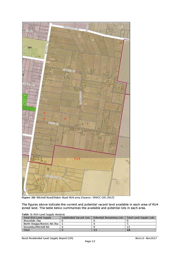
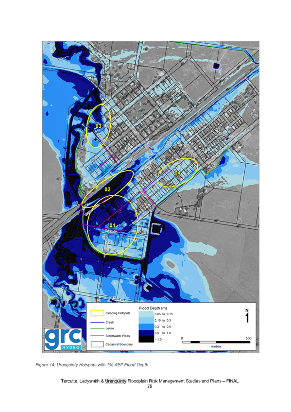
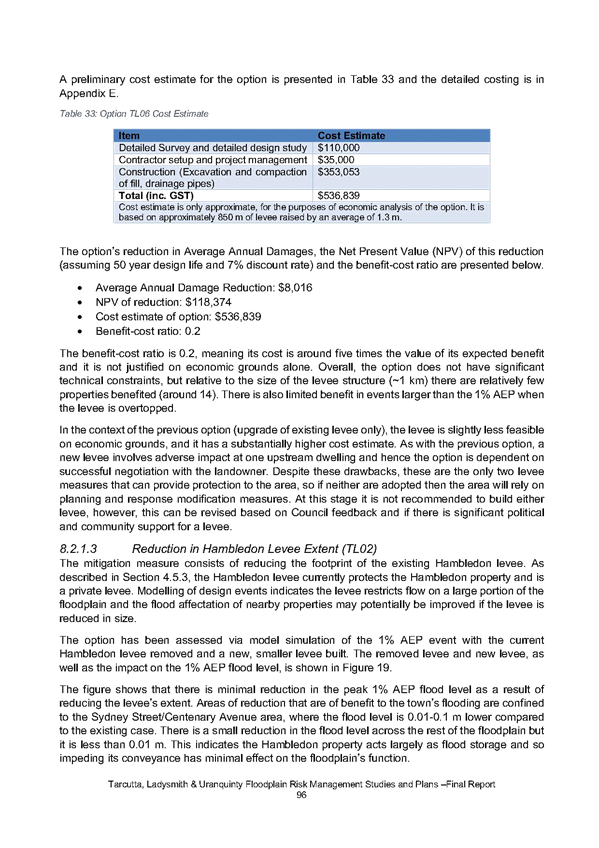
Figure 9.5.2a – Gregadoo and Tallowood Precinct
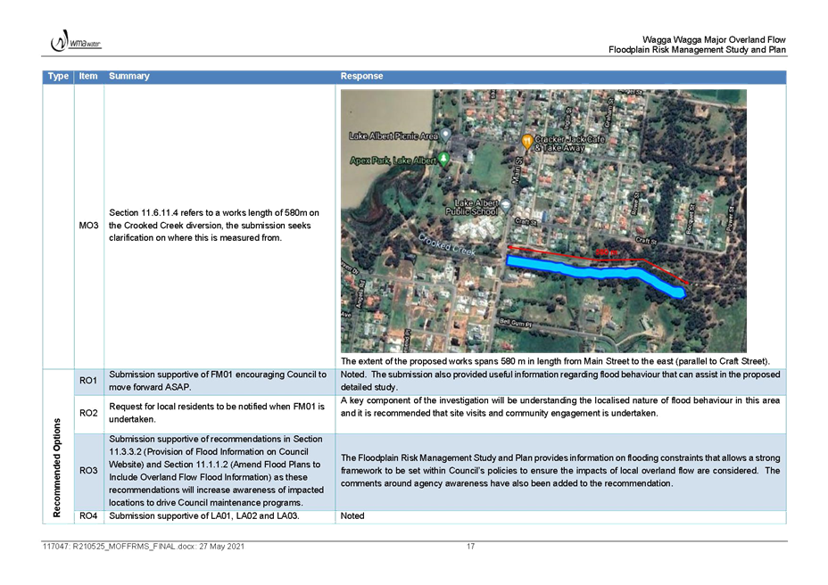
Development within this Precinct shall comply with the requirements of Section 9 of the DCP, as well as this Section. Where there is an inconsistency between this Section and Section 9 of the DCP applying to land in this Precinct, then Section 9.5.2 shall prevail. |
|
|
Principles P1 Facilitate opportunities for the appropriate intensification of land. P2 Retain the established rural and landscape character of the area, including the retention of trees where possible. P3 Ensure that sites have sufficient areas to achieve adequate access, parking, landscaping, and building separation. P4 Incorporate appropriate interface/buffer treatments to minimise land use conflicts with surrounding lands. P5 Provide a clear and legible road hierarchy that promotes connectivity and permeability. P6 Minimise traffic and road safety impacts with Gregadoo Road. P7 Ensure that land is serviced with all necessary infrastructure and services. P8 Identity staging details that will achieve a coordinated and staged approach to land development. |
|
|
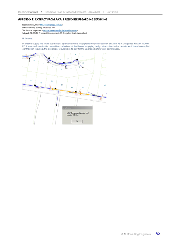
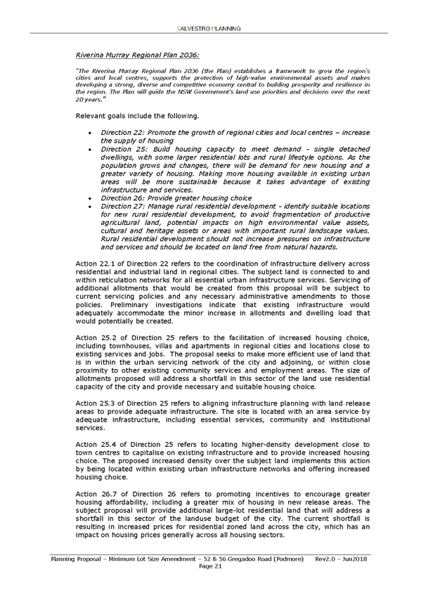
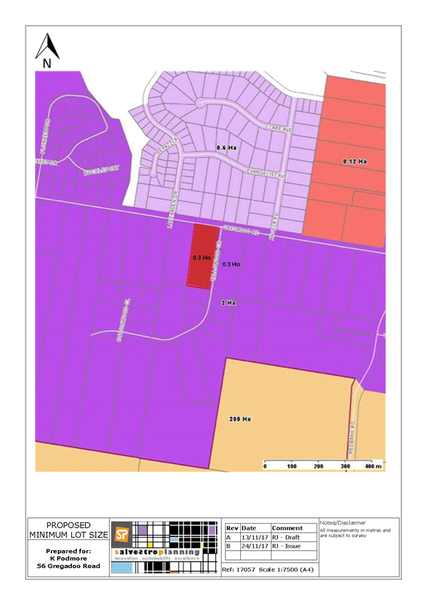
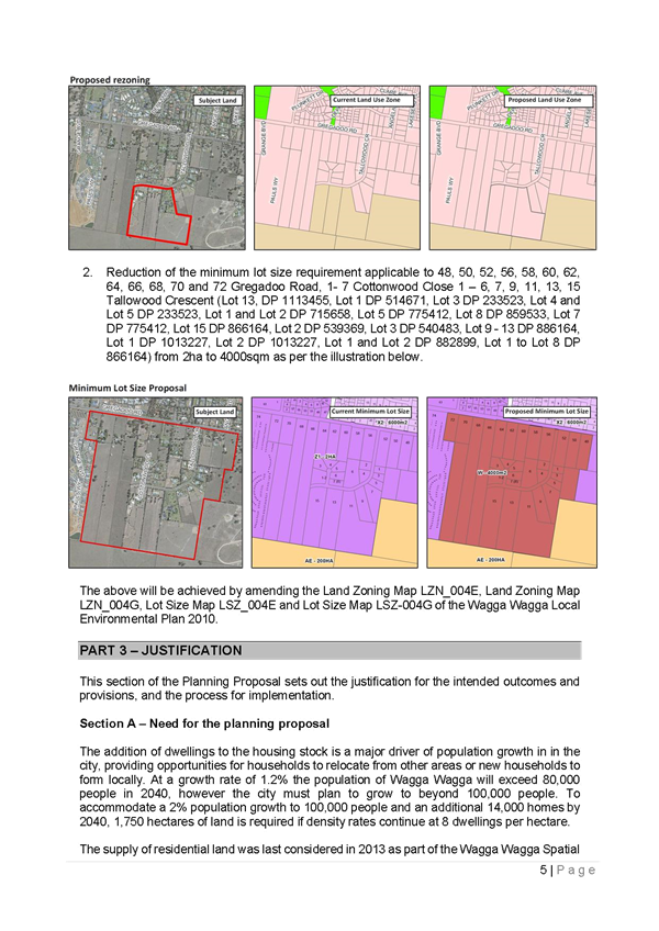
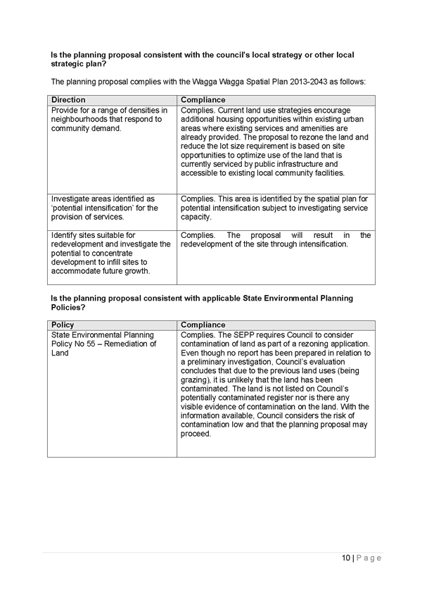
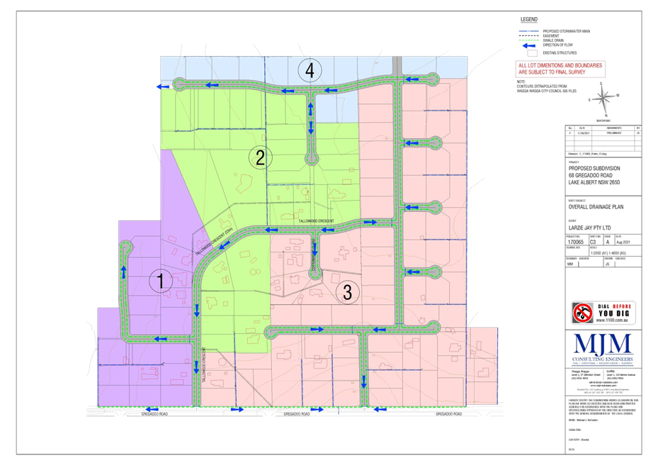
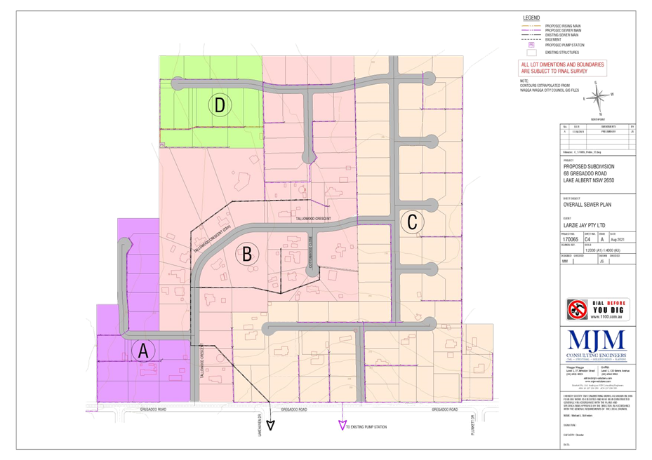
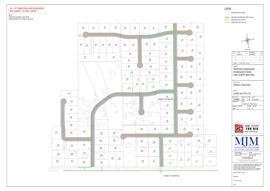
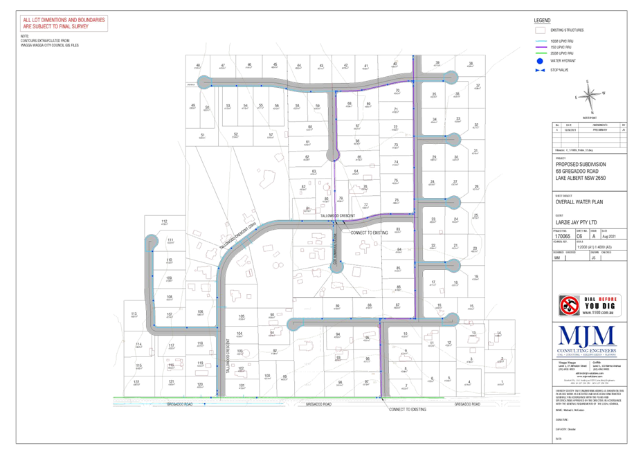
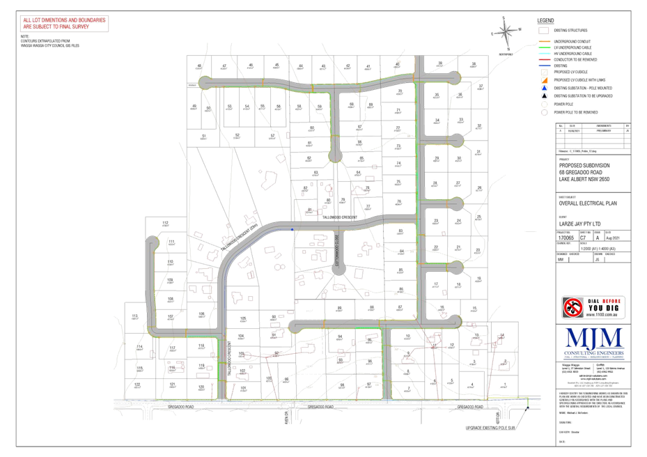
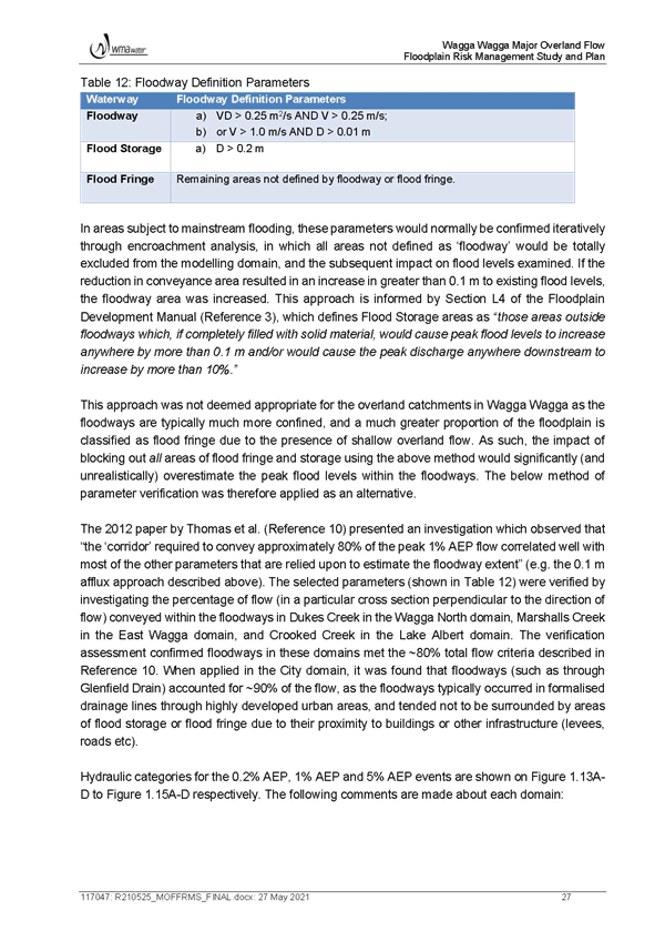
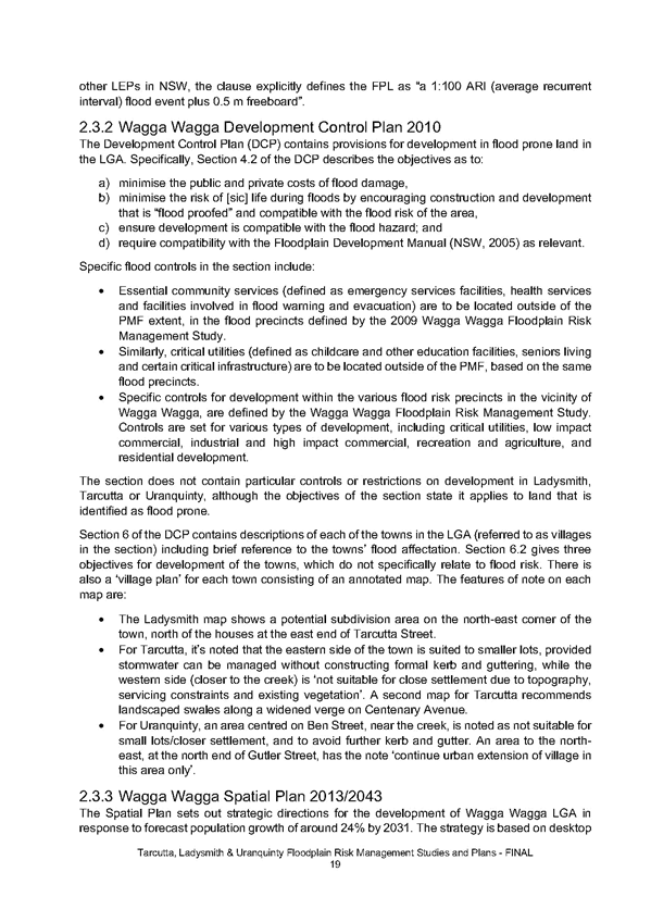
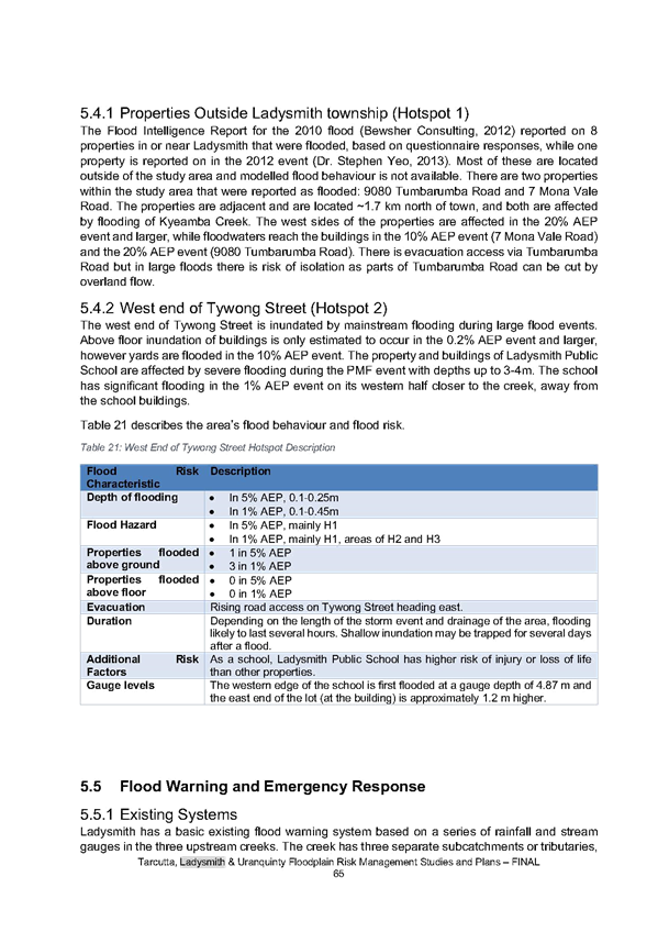
Controls C1 Applications for subdivision and development (including staging) shall be in accordance with the desired connections identified in figure 9.5.2b, ensuring Tallowood Crescent remains a cul-de-sac. C2 Development adjoining the Tallowood Crescent cul-de-sac head is to consider merits of a pedestrian access or infrastructure easement connection in consultation with Riverina Water County Council and Wagga Wagga City Council to ensure infrastructure servicing requirements can be addressed. C3 The development will be staged, commencing at Gregadoo Road and progressing south to ensure orderly and economic provisions of services. If development is proposed that is inconsistent which this, the extension of infrastructure through undeveloped land will be the responsibility and at the cost of the developer. C4 The developer shall be responsible for providing reticulated mains sewer supply to all allotments, including associated pump stations where required, to the satisfaction of Council. Detailed sewer design plans and on-site effluent decommissioning plans must be submitted with the development application. C5 Subdivision within the Precinct shall occur in accordance with a stormwater management plan prepared for the area that addresses both stormwater management and overland flooding impacts. This plan shall ensure that post development flows do not exceed pre-development flows, for both quantity and quality, for storm events up to and including the 1 in 100-year storm event. C6 Development within the Precinct shall occur in accordance with a traffic impact assessment that identifies road and intersection improvements, including the need to restrict the number of individual access points onto Gregadoo Road. C7 Appropriate buffer areas shall be provided to adjoining RU1 Primary Production zoned land to the south. |
|
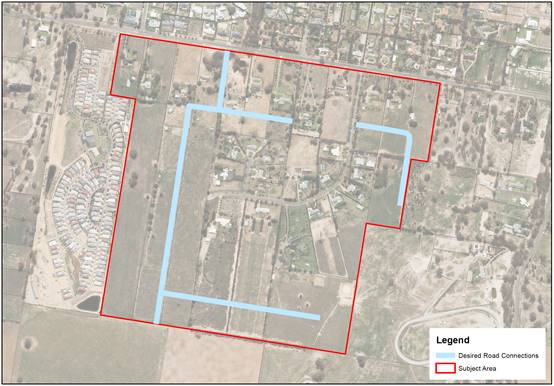
Figure 9.2.5b – Gregadoo and Tallowood Precinct Desired Connection Map
|
1 |
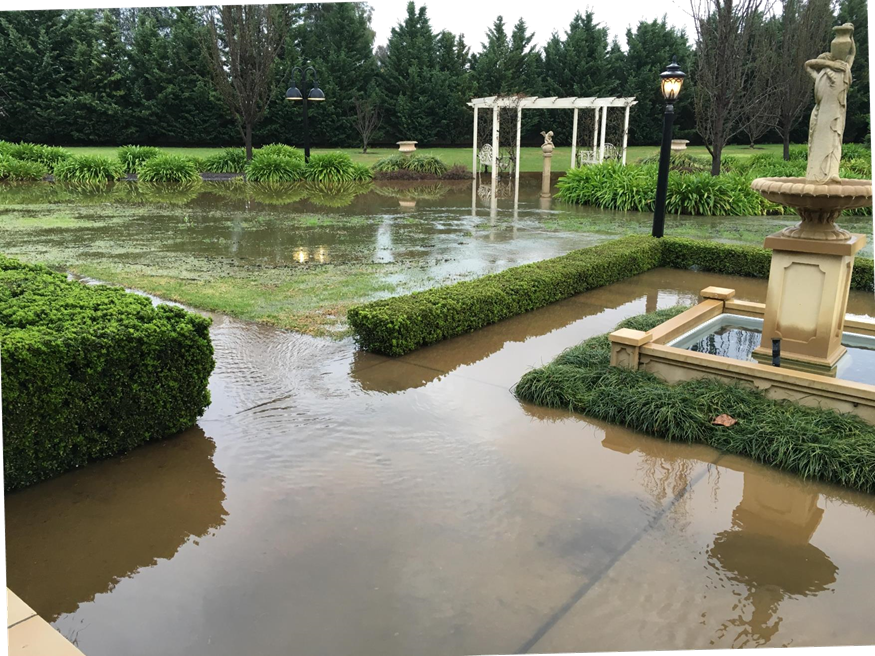
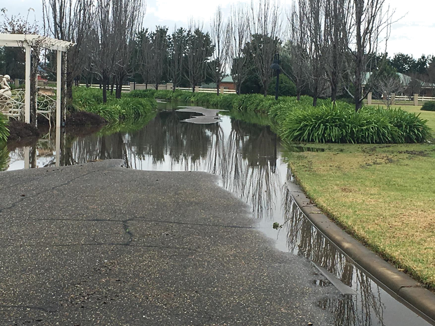
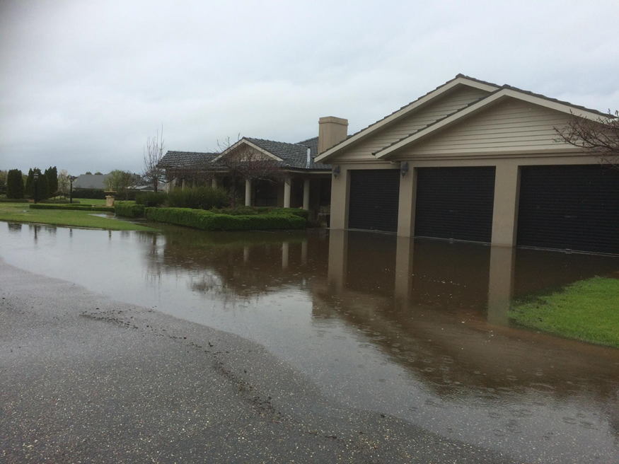
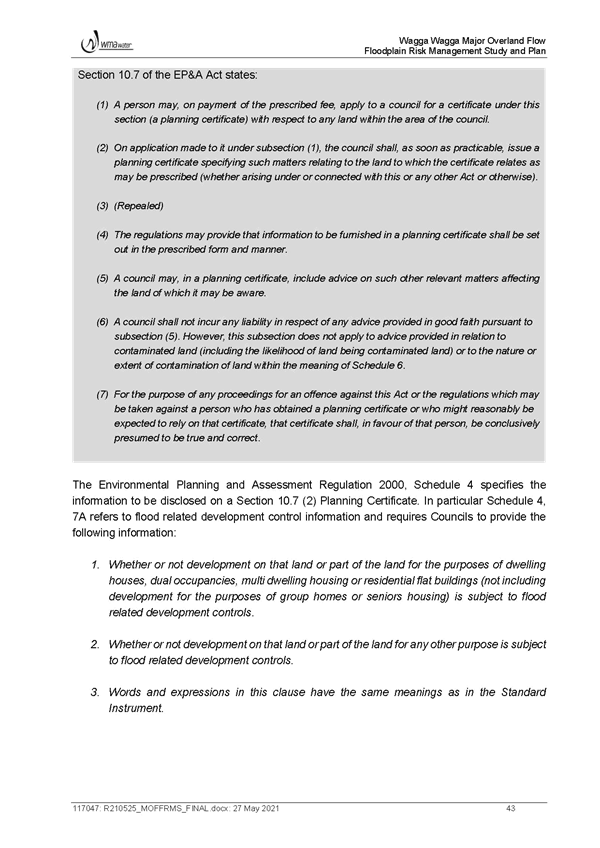
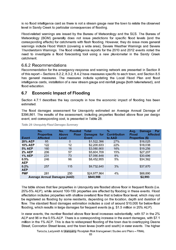
Stormwater: § Stormwater drainage is non-existent with flooding of the roads occurring. |
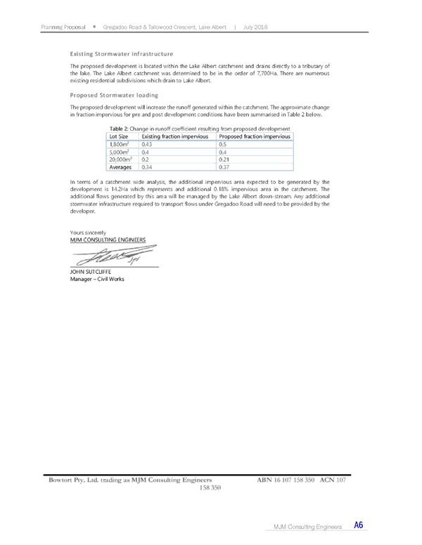
Stormwater calculations are based on average runoff rates based on stormwater modelling standards and are in accordance with the size and form of development proposed. Calculations will be remodelled and reviewed at subdivision development application stage.
New developments will need to provide further evidence and model stormwater flow which includes existing flows and how they are managed as part of any new development proposal. New development will need to demonstrate and confirm they are not impacting on adjoining properties.
Development will redirect some of the existing stormwater and may improve drainage issues. The stormwater network, both piped and overland or open drains, is designed for specific 1 in 10-year events and it is expected that roads will be inundated during some storm events, but they won’t have a long duration.
Council will continue to monitor and improve existing stormwater networks as required. |
|
2 |
Amenity / Character: § Our amenity and way of life would be interrupted by traffic flow, as well as the necessary infrastructure needed to upgrade our area for water, electricity, and other services. § We have no streetlights which makes it a pleasant and quiet area to live, with few cars using the area except for the residents. § Uniform minimum lot size does not take into consideration the diversity of lifestyle that should be provided in a large lot residential community. § The reason for purchasing in this area would be impacted by traffic flow and the changing from large lot residential to suburbia. § The likes of homes built in Main Street, Lake Albert all have the same look and flavour, is that what will happen with this proposal? |
See response to Amenity / Character under Submission 1. |
|
Trees: § Tallowood Crescent is renowned for its beauty with visitors taking photos of the avenue of trees. § Subdivision will impact on the trees. Council should have a policy against removal of trees. § What about the trees, how many will need to be cut down to facilitate driveways? |
See response to Trees under Submission 1. |
|
|
Consultation and Exhibition Material: § Consultation with the local community and available information has been inconsistent and ad hoc. § We note the information available about these proposed changes on the Connect Wagga link is incomplete and does not provide all the required information. § Transparency and open information regarding the proposal has been lacking and residents have been left wondering what is going on. § Submissions from 2018 should be considered and acknowledge the residents say no. |
See response to Consultation and Exhibition Material under Submission 1. |
|
|
Gregadoo Road Upgrade: § Gregadoo Road is disgusting and increasing traffic from the school and retirement village shouldn’t have been allowed. |
See response to Gregadoo Road Upgrade under Submission 1. |
|
|
2 |
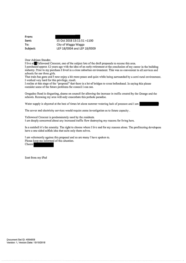
Water: § Water supply is abysmal at the best of times, let alone in summer watering lack of pressure. |
Extension of the existing water main, whilst not guaranteed, may improve water pressure, however some pressure issues may be a result of internal property connections or plumbing fixtures.
Consultation has been undertaken with Riverina Water who have indicated there is capacity and no identified issues with infrastructure in this area.
Council will continue to liaise with Riverina Water County Council on the best approach. |
|
Tallowood Crescent: § Tallowood Crescent is predominantly used by residents, concerned about any increased traffic flow destroying the reasons for living there. § Ultimate desire of residents would be to have Tallowood Road become a cul-de-sac. |
See response to Tallowood Crescent under Submission 1. |
|
|
Process: § Great meeting at Lake Albert Hall on 27/5/21. § Feel like it is a money grab by landowners / developers. |
The full consultation outcomes will be provided to Councillors in the report, including all submissions received in 2018 and community workshop summaries. |
|
|
Stormwater: § Stormwater infrastructure is non-existent. |
See response to Stormwater under Submission 1. |
|
|
3 |
Consultation and Exhibition Material: § Consultation with the local community and available information about these changes has been inconsistent and ad hoc. § The available information on the Connect Wagga page is incomplete and does not provide all the required information. |
See response to Consultation and Exhibition Material under Submission 1. |
|
Amenity / Character: § Concerns for the quality of life and streetscape that lot sizes of 4,000m² would create. § The lot size proposed does not take into consideration the diversity of lifestyle that should be provided in large lot residential communities. |
See response to Amenity / Character under Submission 1. |
|
|
Infrastructure / Servicing: § Concerns for the basic services and traffic that future lot sizes of 4,000m² would create. |
See response to Infrastructure / Servicing under Submission 1. |
|
|
4 |
Water: § Already have issues with water pressure and changes to the minimum lot size will make this issue worse. |
See response to Water under Submission 2. |
|
Tallowood Crescent: § Have issues with Tallowood Crescent being a narrow road and changes to the lot size will make this issue worse. § Believe the current residents will be worse off if Tallowood Crescent is linked through to the proposed new road. |
See response to Tallowood Crescent under Submission 1. |
|
|
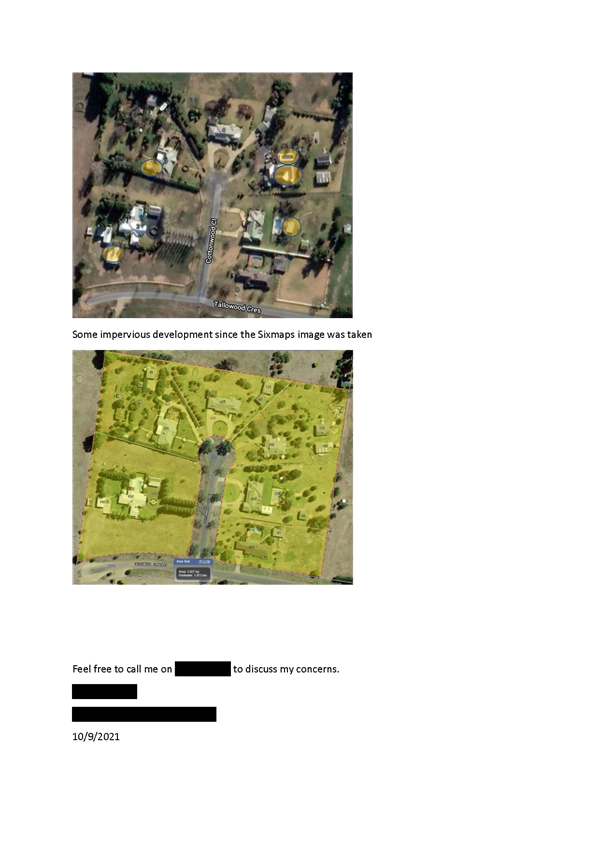
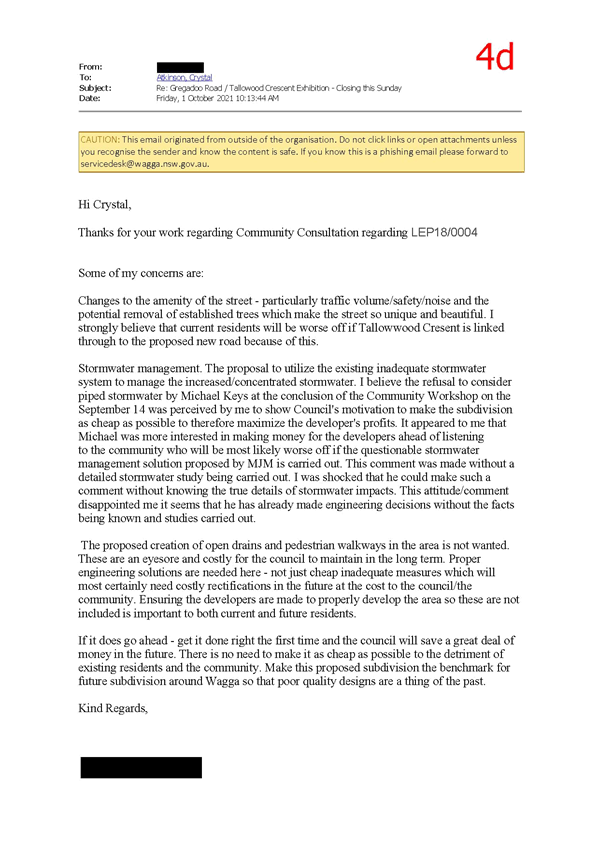
Amenity / Character: § Changes to the amenity of the street, particularly traffic volume, safety, and noise and the potential removal of established trees which make the street unique and beautiful. |
See response to Amenity / Character under Submission 1. |
|
4 |
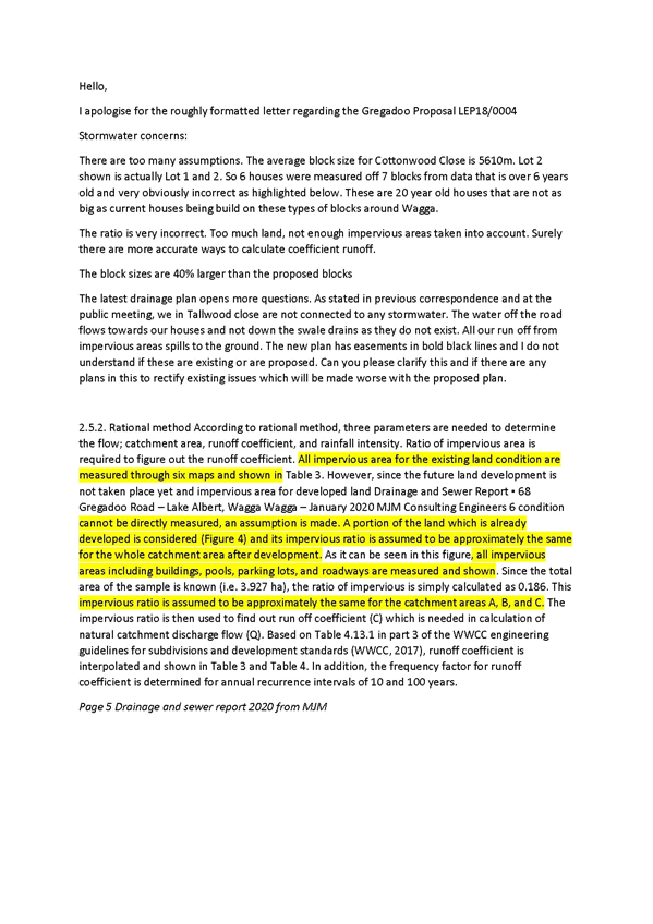
Stormwater: § There is a lack of stormwater infrastructure and changes to lot size will make this issue worse. § My property does not have any stormwater services and I wonder why I pay rates when we are managing stormwater ourselves. § Swale drains do not exist and water off the nature strip and road flows towards my house foundations and compromising the structural integrity of my house slab. § The streets of Tallowood Crescent and Cottonwood Close are of a poorly designed and approved subdivision and the non-existent stormwater management is a clear example of this. § Further poor designs being approved in the future would make existing conditions worse. § There are too many assumptions with stormwater modelling. The ratio is incorrect with too much land and not enough impervious areas considered. There should be more accurate ways to calculate coefficient runoff. § The drainage plans open more questions. § Three parameters are needed to determine flow, catchment area, runoff coefficient, and rainfall intensity. All impervious areas for existing land conditions are measures through six maps, however, since the future and development has not taken place yet, assumptions are made. § Consideration should be given to piped stormwater rather than relying on proposed stormwater solutions provided by the developer. § The proposed creation of open drains is not wanted, they are an eyesore and costly for Council to maintain. Proper engineering solutions are needed, not just cheap inadequate measures. Ensure developers are made to properly develop the area so these are not included as this is important for both current and future residents. § Piped stormwater to the Lake would help with the health and condition of the Lake. Developers could pay for a solution to help with Lake issues, not the Council. |
See response to Stormwater under Submission 1. |
|
Amenity and Character: § If it does go ahead, get it done right the first time, there is no need to make it as cheap as possible to the detriment of the existing residents and community. § Make this proposed subdivision the benchmark for future subdivision around Wagga so that poor quality designs are a thing of the past. |
See response to Amenity / Character under Submission 1. |
|
|
5 |
Consultation and Exhibition Material: § Consultation with the local community has been inconsistent and ad hoc. Information made available about the proposed changes on Connect Wagga website is incomplete and does not provide all the required information. |
See response to Consultation and Exhibition Material under Submission 1. |
|
Minimum Lot Size: § The change to minimum lot size would change it from a mixed lot size residential area to a uniform lot size. |
See response to Minimum Lot Size under Submission 1. |
|
|
Amenity / Character: § Concerns the quality of life and streetscape will change with subdivision to 4,000m² would create. § The change in minimum lot size does not take into consideration the diversity of lifestyle that should be provided in a large lot residential area. |
See response to Amenity / Character under Submission 1. |
|
|
Infrastructure / Servicing: § Concerns with basic services and changes to traffic that subdivision to 4,000m² would create. |
See response to Infrastructure / Servicing under Submission 1. |
|
|
6 |
Consultation and Exhibition Material: § Consultation with the local community has been inconsistent and ad hoc. Information made available about the proposed changes on Connect Wagga website is incomplete and does not provide all the required information. |
See response to Consultation and Exhibition Material under Submission 1. |
|
Minimum Lot Size: § The change to minimum lot size would change it from a mixed lot size residential area to a uniform lot size. |
See response to Minimum Lot Size under Submission 1. |
|
|
Amenity / Character: § Concerns the quality of life and streetscape will change with subdivision to 4,000m² would create. § The change in minimum lot size does not take into consideration the diversity of lifestyle that should be provided in a large lot residential area. |
See response to Amenity / Character under Submission 1. |
|
|
Infrastructure / Servicing: § Concerns with basic services and changes to traffic that subdivision to 4,000m² would create. |
See response to Infrastructure / Servicing under Submission 1. |
|
|
7 |
Consultation and Exhibition Material: § Consultation with the local community has been inconsistent and ad hoc. Information made available about the proposed changes on Connect Wagga website is incomplete and does not provide all the required information. |
See response to Consultation and Exhibition Material under Submission 1. |
|
Minimum Lot Size: § The change to minimum lot size would change it from a mixed lot size residential area to a uniform lot size. § Preference is for no further subdivision in the area. § Bought block believing that subdivision was finished. § Can’t see why this area can’t stay as it is with varied development within a reasonable distance from Wagga centre. What is wrong with variety. |
See response to Minimum Lot Size under Submission 1. |
|
|
Amenity / Character: § Concerns the quality of life and streetscape will change with subdivision to 4,000m² would create. § The change in minimum lot size does not take into consideration the diversity of lifestyle that should be provided in a large lot residential area. § The proposal will change the quiet area to a busy and densely populated one, impacting the rural outlook. |
See response to Amenity / Character under Submission 1. |
|
|
Infrastructure / Servicing: § Concerns with basic services and changes to traffic that subdivision to 4,000m² would create. |
See response to Infrastructure / Servicing under Submission 1. |
|
|
Rates / Property Values: § For those not wishing to subdivide, what is the future of rates? Will rates be based on the number of blocks that could be achieved. |
Rates are determined by property values and where property values increase, rates can change. It is anticipated that property values will increase over time, the market will determine how this occurs on the ground.
The impact on property values is not a planning related consideration and cannot be considered as relevant grounds to refuse a planning proposal. The Valuer General determines land value based on ‘highest and best permitted use’ and in most cases, this is based on current zoning and planning restrictions. Land value is on land only and not the value of structures on the land. |
|
7 |
Roads: § Transport 4 NSW recently did a letter box drop indicating they have concerns about not adversely impacting residents at Edward St / Murray St intersection, Council does not have the same concerns about Tallowood / Cottonwood residents. |
Council has considered local traffic impacts and agree that Tallowood Crescent will remain closed and not extended or opened up further. |
|
Gregadoo Road Upgrade: § Gregadoo Road is in a very bad state and the last thing it needs is more traffic. |
See response to Gregadoo Road Upgrade under Submission 1. |
|
|
Process: § Councillors were not told that most people (85%) in Tallowood Crescent and Cottonwood Close were not in favour of the development in 2018. |
See response to Process under Submission 2. |
|
|
8 |
Consultation and Exhibition Material: § Consultation with the local community has been inconsistent and ad hoc. Information made available about the proposed changes on Connect Wagga website is incomplete and does not provide all the required information. |
See response to Consultation and Exhibition Material under Submission 1. |
|
Minimum Lot Size: § The change to minimum lot size would change it from a mixed lot size residential area to a uniform lot size. |
See response to Minimum Lot Size under Submission 1. |
|
|
Amenity / Character § Concerns the quality of life and streetscape will change with subdivision to 4,000m² would create. § The change in minimum lot size does not take into consideration the diversity of lifestyle that should be provided in a large lot residential area. |
See response to Amenity / Character under Submission 1. |
|
|
Infrastructure / Servicing: § Concerns with basic services and changes to traffic that subdivision to 4,000m² would create. |
See response to Infrastructure / Servicing under Submission 1. |
|
|
9 |
Consultation and Exhibition Material: § Consultation with the local community has been inconsistent and ad hoc. Information made available about the proposed changes on Connect Wagga website is incomplete and does not provide all the required information. |
See response to Consultation and Exhibition Material under Submission 1. |
|
Minimum Lot Size: § The change to minimum lot size would change it from a mixed lot size residential area to a uniform lot size. |
See response to Minimum Lot Size under Submission 1. |
|
|
Amenity / Character: § Concerns the quality of life and streetscape will change with subdivision to 4,000m² would create. § The change in minimum lot size does not take into consideration the diversity of lifestyle that should be provided in a large lot residential area. § Purchased in the area due to it being quiet and peaceful with no streetlights, don’t open up Tallowood Crescent, keep it closed off to traffic to retain the lifestyle that is valued. |
See response to Amenity / Character under Submission 1. |
|
|
Infrastructure / Servicing: § Concerns with basic services and changes to traffic that subdivision to 4,000m² would create. |
See response to Infrastructure / Servicing under Submission 1. |
|
9 |
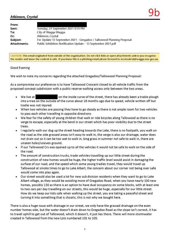
Tallowood Crescent: § As a compromise, our preference is to have Tallowood Crescent closed off to all vehicle traffic with a public reserve walking access only between the two areas. § Accidents have occurred on Tallowood Crescent curve. § When two vehicles are passing, they have to go steady as there is not ample room for two vehicles to pass each other travelling in opposite directions. § Fear for the safety of young children that walk or ride bicycles along Tallowood Crescent as there is no verge to escape, especially at the bend in our street with has poor visibility due to street trees. § There is no footpath, having to walk on the side of the road as the grassed verge is not easy to walk on as it is also drainage and water does not drain so it is too wet to walk in or the grass is too long and not safe. If Tallowood Crescent was extended, it would not be safe to walk on. § The amount of construction trucks, trade vehicles using Tallowood during construction would increase causing damage to the road and they travel at speed making it dangerous. |
See response to Tallowood Crescent under Submission 1. |
|
Stormwater: § There is an issue with drainage with only grassed drainage on one side of the street with the slope incorrect and the water pools in place or drains towards the houses. |
See response to Stormwater under Submission 1. |
|
|
Water: § Water pressure is hopeless. In summer you need to choose to have air con on or the sprinkler, you can’t have both. Have installed a water tank with a pump to be able to water trees. § If access between Tallowood Crescent and the new development is kept as a public reserve for pedestrian access only, the water main connection could be linked from the new subdivision to existing homes in Tallowood Crescent / Cottonwood Close which could assist with water pressure. |
See response to Water under Submission 2. |
|
|
Process: § Thank Council staff for their Community Information Sessions, to be able to talk openly about our concerns and discuss possible scenarios to retain our lifestyle has been appreciated. |
Noted and acknowledged. |
|
|
10 |
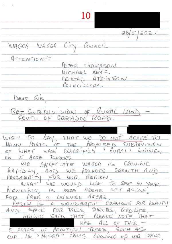
Minimum Lot Size: § Do not agree to any proposed subdivision of what was classified ‘rural living’ on 5 acre blocks. |
See response to Minimum Lot Size under Submission 1. |
|
Open Space: § Want to see planning having more areas set aside for park and leisure areas. |
Council’s Open Space Strategy seeks to ensure there is well located, useable, accessible, and connected open space opportunities available to the whole community. The proposed site does not trigger the need for local open space.
The open space provision in the Lake Albert precinct is sufficient and accessible for the proposed development. |
|
|
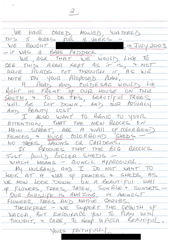
Amenity / Character: § Ask to keep the area as it is and not have roads cut through our property as proposed on the plan. § A road and cul-de-sac would lie in front of our house needing trees to be cut down and privacy and beauty lost. § New blocks on main street are a wall of colourbond fences and huge colourbond sheds with no lawns or gardens. Do not want to be looking at a wall of fences and sheds. |
See response to Amenity / Character under Submission 1. |
|
|
11 |
Amenity / Character § Redevelopment to smaller lots will degrade the rural outlook. |
See response to Amenity / Character under Submission 1. |
|
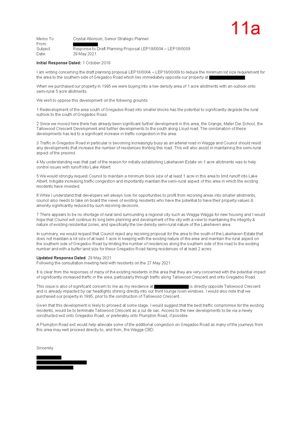
Gregadoo Road Upgrade: § The combination of developments in the area has led to significant increase in traffic congestion. § Traffic on Gregadoo Road is becoming increasingly busy and Council should resist developments increasing the number of residences fronting Gregadoo Road to assist in maintaining the semi-rural aspect of the precinct. § An exit directly onto Plumpton Road would alleviate some of the additional congestion on Gregadoo Road. |
See response to Gregadoo Road Upgrade under Submission 1. |
|
|
Minimum Lot Size: § Understand the reason for initially establishing Lakehaven Estate on 1 acre (4,000m²) allotments was to help control issues with runoff into Lake Albert. Strongly suggest Council to maintain a minimum block size of at least 1 acre in this areas to limit runoff into Lake Albert, mitigate increasing traffic congestion and maintain the semi-rural aspect of this area which existing residents have invested in. § There appears to be a shortage of rural land surrounding Wagga and hope that Council continue its long term planning and development of the city with a view to maintaining the integrity and nature of existing residential zones, specifically low density semi-rural nature of Lakehaven area. § Request Council reject any proposal for the area south of Lakehaven Estate that does not maintain a lot size of at least 1 acre in keeping with the existing nature of the area and to maintain the rural aspect on the southern side of Gregadoo Road. |
See response to Minimum Lot Size under Submission 1. |
|
|
Rates / Property Values: § While developers look to maximise profits from rezoning into smaller lots, Council needs to take on board the views of existing residents who have the potential for their property values and amenity to be significantly reduced by such decisions. |
See response to Rates / Property Values under Submission 7. |
|
|
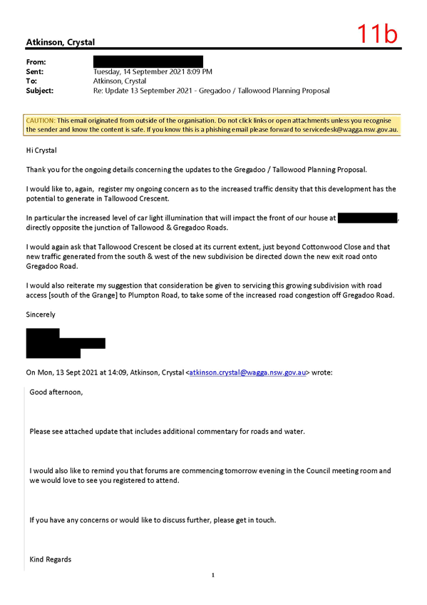
Tallowood Crescent: § Increasing traffic on Tallowood Crescent is a concern as I am directly opposite Tallowood Crescent and already impacted by car headlights shining directly into front windows. § Best compromise is to terminate Tallowood Crescent as a cul-de-sac with access to new developments via a new exit onto Gregadoo Road. |
See response to Tallowood Crescent under Submission 1. |
|
|
12 |
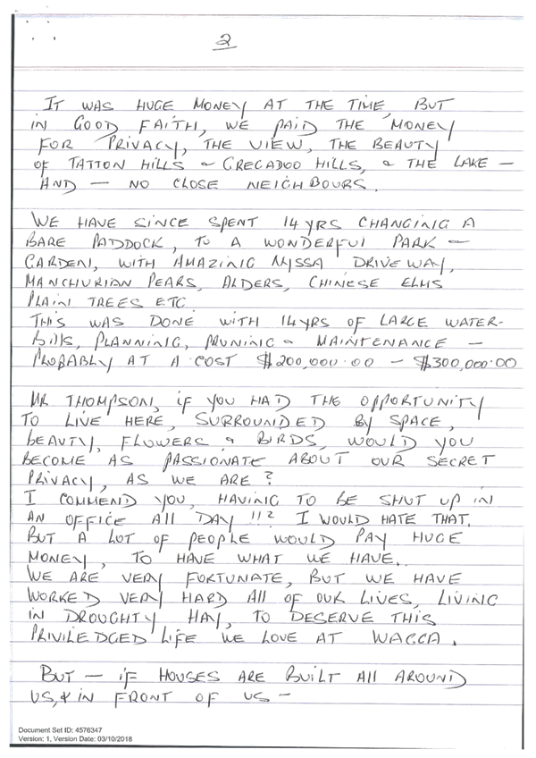
Support: § We love Lake Albert and would like to build out there but there is a lack of suitable land. § The civil infrastructure and community services and parks are all at your fingertips. § It’s a great place. § Boorooma has no supermarket and no attraction like the lake and the lots are very small. § Put the development through, the majority will benefit. |
The support is noted. |
|
13 |
Support: § As a long-term resident of Lake Albert, wish to express support for the proposed rezoning. § Our home and most of our street are blocks of around 4,000m², this size block is most appropriate for residents seeking space and privacy without the responsibility of maintaining unused or not required land. § It creates a very attractive and manicured streetscape while preserving the predominantly natural surroundings. § Growing the number of available blocks of land south of Lake Albert, will provide opportunities for an increased number of families to live in a very desirable part of the city. § It will be attractive to families seeking access to Mater Dei Primary School. § Adds business opportunities for the growing number of businesses at Lake Albert Shopping Centre. § It is a natural progression on the fringe to move from 1,000m² to 4,000m² and then to hobby farms of 5 to 20 acres. For this to happen, hobby farms must slowly move further out. § Support the rezoning and further development of blocks of land of approximately 4,000m². |
The support is noted. |
|
14 |
Stormwater: § Our stormwater runs under the back fence into the paddock behind us and if development goes ahead, the stormwater will run directly onto the new blocks proposed. This will cause issues for whoever purchases the blocks and rectification costs should be addressed by Council or the developer, not us. |
See response to Stormwater under Submission 1. |
|
Gregadoo Road Upgrade: § Gregadoo Road needs to be improved and widened with roundabouts. These works should be carried out before any subdivision works occur. |
See response to Gregadoo Road Upgrade under Submission 1. |
|
|
Tallowood Crescent: § Widening of Tallowood Crescent to cater for additional traffic would mean existing trees would have to be removed and we don’t agree with this. § Tallowood Crescent should be kept as a cul-de-sac with a walking track adjoining the two areas |
See response to Tallowood Crescent under Submission 1. |
|
|
Process: § Not against development, just want it to be done with all concerns addressed before it is approved. |
See response to Process under Submission 2. |
|
|
15 |
Minimum Lot Size: § Whilst the lot layout is indicative, if the minimum lot size change was approved, the objective of the R5 Large Lot Residential Zone could not be achieved. |
See response to Minimum Lot Size under Submission 1. |
|
Water: Riverina Water County Council have advised that they would have capacity in the existing network to service the potential increase in density, however, currently the water pressure to our block is low. During peak watering times in summer when residents are watering gardens, there is extremely low water pressure. Concerned that an increase in the number of consumers will result in even lower water pressure. |
See response to Water under Submission 2. |
|
|
Infrastructure / Servicing: Our block is serviced by gravity sewer to the Kooringal Sewerage Treatment Plan. The proposal does not account for the increased effluent treatment usage of this facility, only the extra pumping facilities that will be required to deliver the extra effluent to be treated. |
See response to Infrastructure / Servicing under Submission 1. |
|
15 |
Amenity / Character: § The indicative lot layout appears to pack lots into an area with some lots not having street access, is this necessary? Does the only lot size have to be 4,000m²? If there were larger lots, located in the proposed areas, there would be more feeling of ‘open space’ and scenic quality and be consistent with the R5 zone objective of providing housing in a rural setting. § The indicative lot layout doesn’t hinder future urban development as it is an urban area as per R5 zone objective of ensuring large lot residential lots do not hinder the proper and orderly development of urban areas in the future. § Currently there are no streetlights in this area. The approval of the indicative plan would create the need for street lighting given the increase in traffic and population. Introducing street lighting will detract from the ‘scenic quality’ of our current rural setting. § Some residents have livestock there may be pressure on current residents to remove current livestock. |
See response to Amenity / Character under Submission 1. |
|
Stormwater: § Currently our subdivision does not have kerb and gutter. Our stormwater is managed with gradient easements, which flow along Tallowood Crescent into Gregadoo Road. Cottonwood Close also has gradient easements running down both sides of the road, along housing block boundaries and through some properties. The submission does not adequately address the extra runoff that will be channelled into the existing stormwater facility. |
See response to Stormwater under Submission 1. |
|
|
Tallowood Crescent: § The road is not designed for heavy traffic flow. As residents of Cottonwood Close, we have enjoyed minimal traffic flow and rural setting. The rural setting could be preserved with the permanent closure of Tallowood Crescent. |
See response to Tallowood Crescent under Submission 1. |
|
|
Gregadoo Road Upgrade: § Gregadoo Road is currently in a disgraceful state with potholes, uneven surface and stormwater running onto the road. |
See response to Gregadoo Road Upgrade under Submission 1. |
|
|
Trees: § If the indicative layout is approved, there may not have to be a large amount of clearing of native vegetation, however it would be disappointing to see the removal of tress on the avenue on Tallowood Crescent. |
See response to Trees under Submission 1. |
|
|
16 |
Support: § The subdivision would be an excellent residential development for the residents of Gregadoo. |
The support is noted. |
|
17 |
Support: § I am in favour of the subdivision. |
The support is noted. |
|
18 |
No comment: § Online submission completed with no comment. |
Noted |
|
19 |
Support: § Signing to subdivide |
The support is noted. |
|
20 |
No comment: § Online submission completed with no comment.
|
Noted |
|
21 |
Support: § In agreement with the proposal. |
The support is noted. |
|
22 |
Support: § Good planning idea. |
The support is noted. |
|
23 |
Support: § I am in favour of the subdivision. |
The support is noted. |
|
24 |
Support: § In favour of subdivision |
The support is noted. |
|
25 |
Support: § In favour of the subdivision. |
The support is noted. |
|
26 |
Support: § I am in favour of the subdivision. |
The support is noted. |
|
27 |
Support: § Allow subdivision at Gregadoo Road. |
The support is noted. |
|
28 |
No comment: § Online submission completed with no comment. |
Noted |
|
29 |
No comment: § Online submission completed with no comment. |
Noted |
|
30 |
Support: § I am in favour of the subdivision. |
The support is noted. |
|
31 |
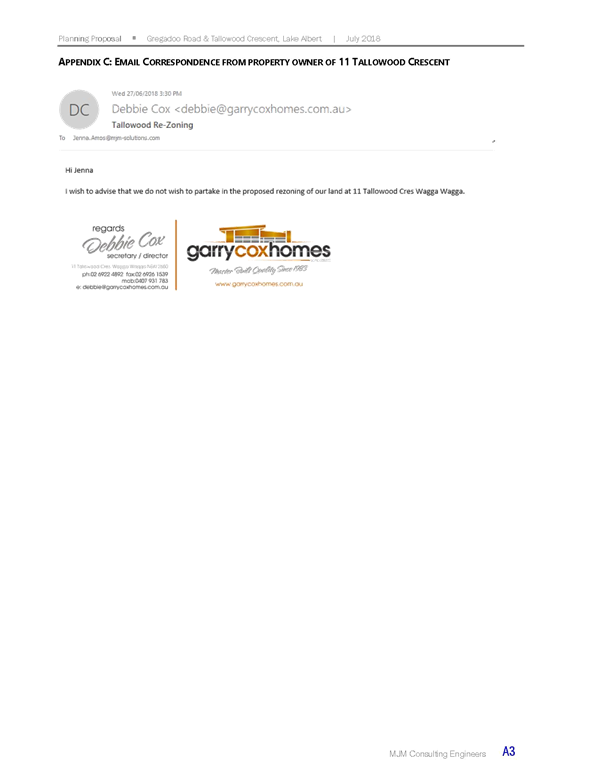
Process: § The proposal involves our land and at no point, either in writing or verbal have we spoken of subdividing our property with any developers. |
See response to Process under Submission 2. |
|
Minimum Lot Size: § We do not intend to have a road behind our home on our land. We will not be subdividing our property as per this draft plan and any further plans are to show our property remaining as a 5 acre land holding. |
See response to Minimum Lot Size under Submission 1. |
|
|
Tallowood Crescent: § Tallowood Crescent should remain as is and not become a through road. |
See response to Tallowood Crescent under Submission 1. |
|
|
32 |
Stormwater: § Any subdivision will be affected by stormwater runoff for any weather event greater than 70mm. The water line on the proposed plan is incorrect and should be moved west by 1-2 blocks. Still want to direct any runoff from 0-60mm south of our property to the east of Old Redbank Road, but events greater than 60mm would run through western paddock of my property to run ease on Gregadoo Road. |
See response to Stormwater under Submission 1. |
|
33 |
Support: § As a landholder supporting the minimum lot size reduction, have participated in several of the council consultation events and read the material available online. § Council has successfully satisfied the concerns of the landholders who oppose the development. § Landowners do not understand that the change in minimum lot size does not mean you have to subdivide. § It is unreasonable to expect land immediately bordering urban development to never be developed. § The proposed lot size is much larger than regular house blocks. § There are several properties in the precinct that are approximately the same size as the lot size being recommended. § It is a positive change for a thriving area that desperately needs more land. |
The support is noted. |
|
34 |
Stormwater: § Have concerns with the mapping Council has for overland flow studies. These appear to be incorrect and further investigation is required. Information collected from the topography study was not completed in the correct grid to reflect what actually occurs. § Flooding of the road occurs frequently and any changed level of the road in the upgrade will impact the flow of water onto existing properties. This would impact the level of water flowing through our property from the back and raising the level of road would push water towards our property. § Requesting more detailed hydrology study or independent audit of the existing hydrology study. |
See response to Stormwater under Submission 1. |
|
Process: § We have had lack of consultation in regard to developments. 7 lots have been allocated directly across from our property and no consultation. § Two houses have been built directly behind our property with no consultation. § The lack of consultation is concerning and does not provide us with confidence in Council providing a solution to ensuring we as property owners are not impacted by the current Tallowood / Gregadoo Road proposal. |
See response to Process under Submission 2.
The feedback on notifications for development applications has been noted and referred to the appropriate Council officers. |
|
|
35 |
Amenity / Character: § The proposal will create a substantial reduction and change to this community’s amenity. § Concerns with amenity and noise that have not been alleviated by information provided. § Fail to see how an increase of 130 houses will not change the existing amenity and character of the existing area, particularly if Tallowood Crescent is connected to the proposed subdivision on Gregadoo Road. Due to existing building envelopes, houses are built close to the road and will be disturbed by increased traffic and noise. |
See response to Amenity / Character under Submission 1. |
|
Stormwater: Concerns with overland flow, stormwater management with open swale drains have not been alleviated by information provided. |
See response to Stormwater under Submission 1. |
|
|
Rates / Property Values: Concerns with rates have not been alleviated by information provided. |
See response to Rates / Property Values under Submission 7. |
|
35 |
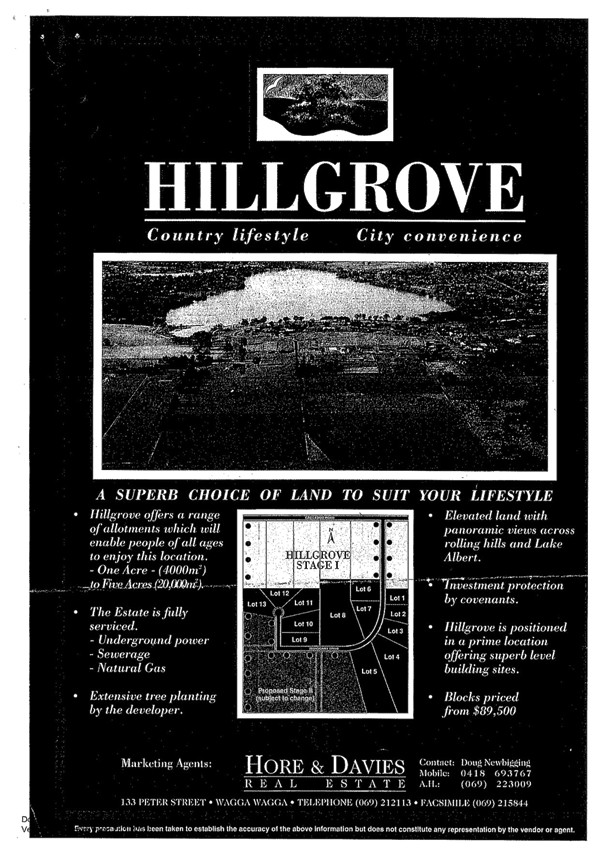
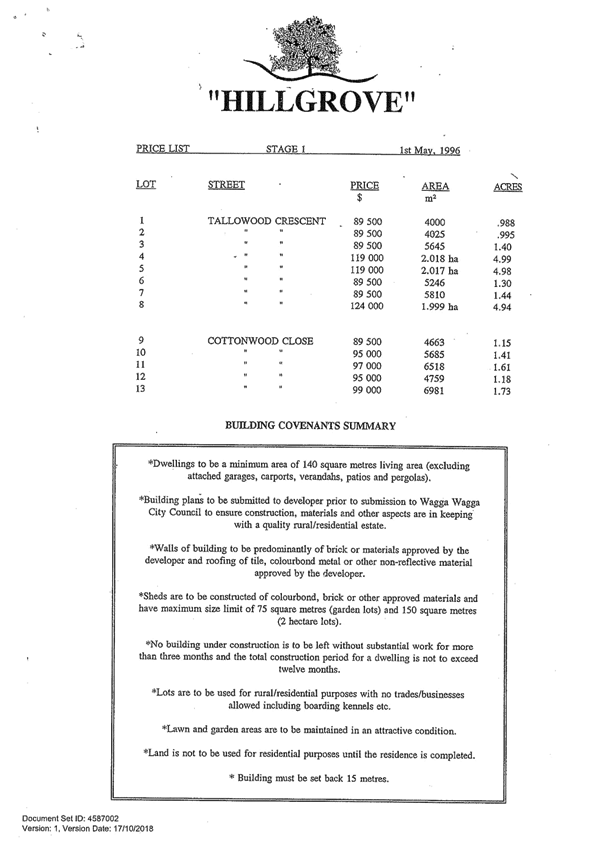
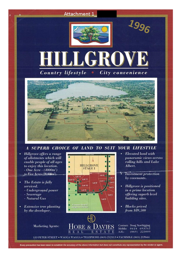
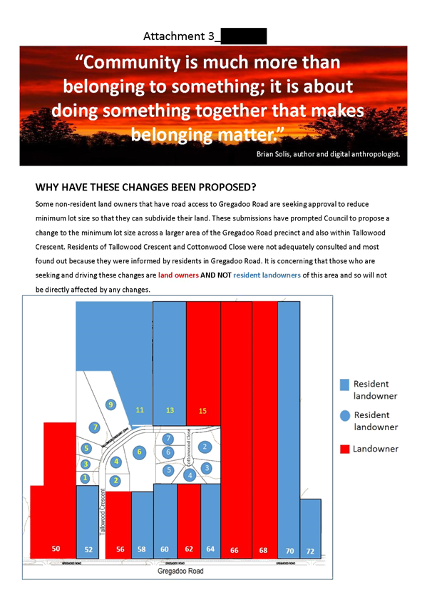
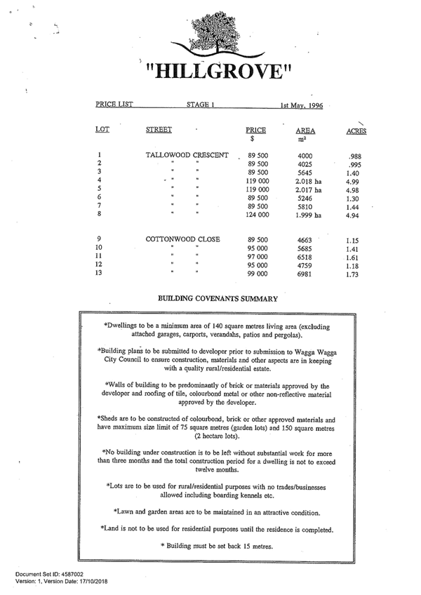
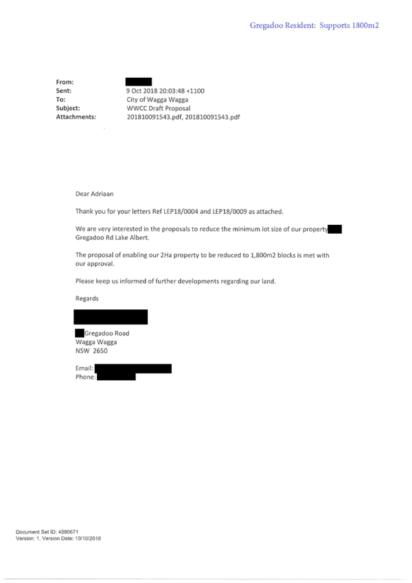
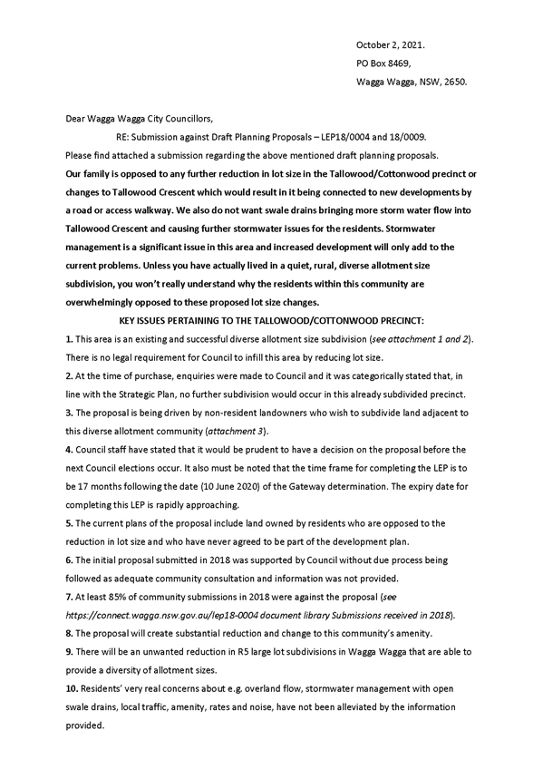
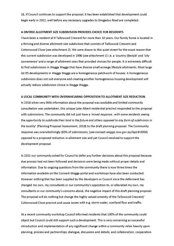
Minimum Lot Size: § This area is an existing and successful diverse allotment size subdivision. There is no legal requirement for Councill to infill this area by reducing lot size. § When purchasing, were told that no further subdivision would occur. § The current plan includes land owned by residents who are opposed to the reduction in lot size and have never agreed to be part of the plan. § There will be an unwanted reduction in R5 large lot subdivisions in Wagga Wagga that are able to provide a diversity of allotment sizes. § Drawn to the area for the reason the subdivision was created in 1996 as a ‘country lifestyle’ and ‘city convenience’ and a range of allotment sizes that provided choice for people. § It is difficult to find subdivisions in Wagga Wagga that have diverse small acreage lifestyle allotments. § Most R5 Large Lot Residential developments in Wagga Wagga are homogeneous patchwork of houses. A homogeneous subdivision does not suit everyone and creating another homogenous housing development will reduce subdivision choice in Wagga Wagga. § The Tallowood Crescent and Cottonwood Close should be seen as a model for future diverse allotment subdivisions. § No valid reason why an already subdivided and successful development should be catastrophically changed to meet the needs of Wagga Wagga’s growing population. § The Tallowood Crescent / Cottonwood Close precinct does not need to be included in this proposal. |
See response to Minimum Lot Size under Submission 1. |
|
Process: § The proposal is being driven by non-resident landowners who wish to subdivide. § Council staff have stated that it would be prudent to have a decision on the proposal before next Council elections – it must be noted that the timeframe for completing the LEP is to be 17 months from the 10 June 2020 and the expiry is approaching. § The initial proposal submitted in 2018 was supported by Council without due process being followed as adequate community consultation and information was not provided. § At least 85% of community submissions in 2018 were against the proposal. § Concerned that if 100% of people object, Council can still support the proposal as the introduction and implementation of any significant change within a community relies upon planning, process, and partnerships. § Infill is not a legal requirement in our city and the Strategic Planning Committee has identified growth areas in the north. Council can choose which precincts are suitable for redevelopment and intensification. § The choice to include Tallowood Crescent and Cottonwood Close in this development proposal ultimately lies with Council, but when an overwhelming proportion of the local community choose to voice concern, it is worth listening and reflecting on past decisions. § Future decisions need to be made so that people within Wagga Wagga still have the choice to live and enjoy what diverse allotment size communities are able to offer. Unless you have lived in one, you won’t understand why the residents have chosen to resist these proposed changes. |
See response to Process under Submission 2.
The current Council has been involved in this proposal and have awareness of the sensitivities and demand for this development. A report will bring the issues to a decision with Council having the ability to support the proposal, support with changes, or refuse the proposal.
All submissions received during the preliminary, initial, and final consultation stages have been provided to Councillors and discussed in the report to ensure full appreciation for the feedback received.
Council has adopted its Local Strategic Planning Statement – Wagga Wagga 2040 which provides the direction for growth and development in Wagga Wagga. The plan identifies the need for growth to be accommodated through a mix of greenfield and infill developments with infill development across exiting areas in the south of the city able to provide further opportunities for housing diversity, affordability, and liveability in established communities. |
|
35 |
Gregadoo Road Upgrade: § If the proposal is supported, development could begin early in 2022 well before any necessary upgrades to Gregadoo Road are completed. § Gregadoo Road required a significant upgrade before it can manage any future increase in residential or building development traffic. § Concerns with local traffic have not been alleviated by information provided. |
See response to Gregadoo Road Upgrade under Submission 1. |
|
Consultation and Exhibition Material: § In 2018 when very little information about the proposal was available and limited community consultation was undertaken, the community did not just have ‘mixed response….with some residents seeing the opportunity to subdivide their land in the future and other opposed to any form of subdivision in the locality’ as reported to Council. § In 2021, the community asked Council to defer any further decisions about the planning proposal as due process had not been followed and decisions were being made without proper details and information. Due to ongoing questions, there is now three times the amount of information available and workshops have been conducted, however, this has not changed the community’s views. |
See response to Consultation and Exhibition Material under Submission 1.
The extended consultation period and additional information was provided in response to community representation. This has identified critical issues and alternatives including extension of Tallowood Crescent not being supported. |
|
|
Tallowood Crescent: § The precinct of Tallowood Crescent and Cottonwood Close should not be subject to further subdivision or connection as the narrow, tree lined road will not safely support the increase in traffic. § Concerns with local traffic have not been alleviated by information. |
See response to Tallowood Crescent under Submission 1. |
|
|
36 |
Amenity / Character: § Living here is the perfect lifestyle, quiet, peaceful, and our haven. |
See response to Amenity / Character under Submission 1. |
|
Minimum Lot Size: § Purchased in 1998 and told that there would be no further subdivision “in our lifetime”. Purchased feeling secure in the fact that we would not be built out with further subdivision. § Concerned with the number of additional blocks proposed on our property boundary and in Tallowood Crescent. § Why does Tallowood Crescent need to be subdivided at all? The range of lot sizes provides choice and is a great mix of property sizes. If some landowners subdivide, what impacts will that have on those who choose not to. § Wagga Wagga has a variety of lot sizes within 15 minutes of the CBD, this draws people to relocate to Wagga. Further subdivision reduces options and creates a cookie cutter approach. Is that what we want? § As developers understand the need for additional land in the right areas. Subdivided land is scarce but subdividing already subdivided areas creates infrastructure issues and loss of amenity. § Tallowood Crescent is on the furthest southern fringe of Wagga and makes sense to leave it as larger rural residential allotments. |
See response to Minimum Lot Size under Submission 1. |
|
|
Process: § The plans include our property which misrepresents the fact that we are not interested in subdivision and have never been. |
See response to Process under Submission 2.
The area as a whole precinct has been identified to consider potential impacts and reduce small scale, site specific outcomes. The option is available for future development but not forced or guaranteed. |
|
36 |
Amenity / Character: § Further subdivision in Tallowood Crescent will destroy the amenity of the area. |
See response to Amenity / Character under Submission 1. |
|
Tallowood Crescent: § Tallowood Crescent is a quiet street with mostly local traffic and odd “Sunday Driver” traffic. It is a narrow street. In favour of Tallowood Crescent remaining a cul-de-sac with a pedestrian connection through to the new development. § Invite staff and Councillors to come out and see how the stormwater and traffic issues affect our property and Tallowood Crescent as a whole. |
See response to Tallowood Crescent under Submission 1. |
|
|
Gregadoo Road Upgrade: § Gregadoo Road is becoming increasingly busier and grateful that the upgrade is occurring. |
See response to Gregadoo Road Upgrade under Submission 1. |
|
|
Schools § With additional subdivisions proposed, are there plans to mitigate school capacity issues? |
School provision to address capacity is driven by NSW Department of Education and private operators. Council assists education providers with long term planning for school capacity through development and population forecasts. |
|
|
Stormwater: § Stormwater is a major issue. Our property has been inundated and occurs regularly after heavy rain and laps onto front verandah. § The stormwater follows the natural water course through our property and whilst we prepared ourselves during the build, there are still issues. § With further subdivision, we will be further impacted by stormwater during rain events. § There is no swale drain on Tallowood Crescent. The part of Tallowood that does have a swale drain is very slow draining with little to no fall and water is held for weeks. § Stormwater flows from the west and enters the front of our property, down our driveway or through our western boundary fence and across the front yard. Concern with being further impacted by additional development and it will occur more frequently. § Development on Gregadoo Road won’t impact our property, but areas further south and west will see stormwater directed to our property. |
See response to Stormwater under Submission 1. |
|
|
37 |
Support: § Thank you for the extensive and thorough approach to community consultation during a difficult year. § Reside in Tallowood Crescent and the proposal would allow us, if we choose to, to access a windfall of excess land not in use. § Understand the concerns of existing residents and acknowledge that the development will bring prosperity to some, a beautiful new place to live for others and disruption to the current way of life for others. § It is understood that existing drainage issues along Tallowood Crescent are a result of previous development and will not be resolved through new development, however, future development will need to occur in a way that these issues are not exacerbated. § There are unstated benefits to Wagga Wagga’s economy allowing for new residents and new homes. |
The support is noted.
See response to Stormwater under Submission 1. |
|
Gregadoo Road Upgrade: § If developer contributions collected for Lake Albert exceed the funds required to complete the Greagadoo Road upgrade, would like to see the drainage issues along Greagdoo Road fully rectified rather than improved or ‘patched up’. |
See response to Gregadoo Road Upgrade under Submission 1. |
|
37 |
Infrastructure and Servicing: § The current Developer Contribution Plans list new projects and upgrades related to Sewer, Stormwater, Roads, Pathways, Recreation Areas, Open Space and Community Facilities and identify projects for Lake Albert. At an estimated $25K to be collected per lot, with 130 new lots proposed, this represents $3.25M in funds that are not yet directed towards infrastructure items. Advocating for funds to address road quality and drainage in the proposed areas. § Note that sewer assets in the Lake Albert Catchment are not at capacity and can adequately handle the increased intake, however, the current movement of sewer seems slow and conclude it to be due to gradient and or pipe size, this isn’t to be repeated and is to be made satisfactory in new development areas. |
The Infrastructure Contributions Framework for Wagga Wagga City Council includes contribution plans and delivery service plans for community infrastructure such as roads, community facilities, open space, and recreation facilities as well as sewer and stormwater infrastructure. The contributions paid by developers are pooled and allocated across the variety of projects across the whole of the City including upgrades to Gregadoo Road or Lake Albert. The contributions framework is based on forecast growth and the allocations for projects rely on future development to generate the funding for these projects.
Future development such as that proposed will fund the works already identified and not necessarily provide new funding that is unallocated. The contributions plans are subject to ongoing review including the revenue and projects listed. |
|
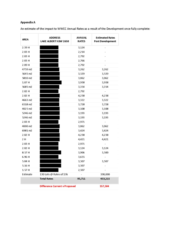
Rates / Property Values § Council collects $96K per annum in the precinct proposed for development. Once land is fully completed, rates collected would reach $435K per annum. An increase of $357K per annum for WWCC to utilise in delivering and improving services to the community. This increases council capacity to serve and in turn the community ultimately benefits. |
See response to Rates / Property Values under Submission 7. |
|
|
Tallowood Crescent: § Expect traffic to increase in Tallowood Crescent with additional residents in the street and southern west of the precinct. Suggest Tallowood Crescent remain a cul-de-sac with pedestrian access provided to the new development. This is a good compromise that will reduce traffic impacts. . |
See response to Tallowood Crescent under Submission 1. |
|
|
Amenity / Character: § The existing lifestyle is able to be maintained with residents able to choose whether or not to develop. The community spirit will endure, and new friendships will be made. § Fencing is a small item but can impact a suburb. Fencing is dealt with as part of development conditions issued and ideally in semi-rural / larger lot settings, front fences at least are ‘see through’ allowing for a certain look and feel of openness and tidy lawn / house proud focused residents. This should be sustained. |
See response to Amenity / Character under Submission 1. |
|
|
Biodiversity: § Trust that the impact to wildlife will be dealt with as is always the case with any proposed development. |
Correct, impacts on biodiversity must be addressed and considered as part of any development application. |
|
|
Minimum Lot Size: § Understand a variety of lot sizes were proposed and Council required an all-encompassing lot size for the precinct. The lot size considerations have been dealt with in depth. § The proposal is not changing to high density residential zoning, commercial or industrial and isn’t one of the more controversial and debated developments, like the Murray Street proposal. The planned approach to this precinct is fitting with the pattern of development in Lake Albert and mirrors that of better planned cities within NSW. § It is a natural progression that the circumference around the city centre is continually built out and the densities are required to intensify for the reasons of proximity / convenience. |
See response to Minimum Lot Size under Submission 1. |