 Ordinary Meeting of
Council
Ordinary Meeting of
Council
To be held on
Monday
25 July 2016
AT 6.00pm
Cnr Baylis and Morrow Streets,
Wagga Wagga NSW 2650
PO Box 20, Wagga Wagga
Phone: 1300 292 442
Fax: 02 6926 9199
Website: www.wagga.nsw.gov.au
Ordinary Meeting of
Council
To be held on
Monday
25 July 2016
AT 6.00pm
Cnr Baylis and Morrow Streets,
Wagga Wagga NSW 2650
PO Box 20, Wagga Wagga
Phone: 1300 292 442
Fax: 02 6926 9199
Website: www.wagga.nsw.gov.au
NOTICE OF MEETING
In pursuance of the provisions of the Local Government Act, 1993 and the Regulations there under, notice is hereby given that an Ordinary Meeting of the Council of the City of Wagga Wagga will be held in the Council Chamber, Civic Centre, Corner Baylis and Morrow Streets, Wagga Wagga, on Monday 25 July 2016 at 6.00pm.

Mr Alan Eldridge
General Manager
WAGGA WAGGA CITY COUNCILLORS
|
Mayor Councillor Rod Kendall |
Deputy Mayor Councillor Dallas Tout |
Councillor Yvonne Braid |
Councillor Alan Brown |
|
Councillor Greg Conkey OAM |
Councillor Paul Funnell |
Councillor Gary Hiscock |
Councillor Julian McLaren |
|
Councillor Kerry Pascoe |
Councillor Kevin Poynter |
|
|
QUORUM
The quorum for a meeting of the Council is a majority of the Councillors of the Council who hold office for the time being who are eligible to vote at the meeting.
COUNCIL MEETING ROOM
Reports submitted to the Ordinary Meeting of Council to be held on Monday 25 July 2016.
Ordinary Meeting of Council AGENDA AND BUSINESS PAPER
Monday 25 July 2016
ORDER OF BUSINESS:
CLAUSE PRECIS PAGE
PRAYER 2
ACKNOWLEDGEMENT OF COUNTRY 2
APOLOGIES 2
CONFIRMATIONS OF MINUTES
CM-1 SUPPLEMENTARY COUNCIL MEETING - 11 JULY 2016 2
DECLARATIONS OF INTEREST 2
Reports from Policy and Strategy Committee
PS-1 POLICY AND STRATEGY COMMITTEE MEETING - 11 JULY 2016 3
Motions Of Which Due Notice Has Been Given
NOM-1 COMMUNITY WORKS RESERVE 18
NOM-2 RED HILL ROAD - LOCAL ARTICULATED TRANSPORT 20
Reports from Staff
RP-1 RESPONSES TO QUESTIONS/BUSINESS WITH NOTICE 22
RP-2 GREGADOO ROAD AND PLUMPTON ROAD INTERSECTION - PROPOSED TREATMENT 28
RP-3 GRAY'S LANE PARKING CONTROLS 32
RP-4 HOSPITAL PRECINCT TRAFFIC AND PARKING MANAGEMENT 37
RP-5 MAJOR EVENTS SPONSORSHIP FUND 59
RP-6 ANNUAL GRANTS PROGRAM 2016/2017 63
RP-7 2015/16 CARRYOVERS AND 30 JUNE 2016 INVESTMENT REPORT 73
RP-8 AUSTRALIAN CLAY TARGET ASSOCIATION PROPOSED ACQUISITION OF LAND 86
Confidential Reports
CONF-1 PROPOSED LEASE RENEWAL - BOTANIC GARDENS RESTAURANT SITE 91
CONF-2 PROPOSED VARIATION - AIRPORT SUB-LEASE TO MAGUIRE 92
CONF-3 COUNCIL ORGANISATION STRUCTURE REVIEW 93
QUESTIONS/BUSINESS WITH NOTICE 94
Confirmation of Minutes
CM-1 SUPPLEMENTARY COUNCIL MEETING - 11 JULY 2016
|
That the Minutes of the proceedings of the Supplementary Council Meeting held on 11 July 2016 be confirmed as a true and accurate record.
|
|
1⇩. |
Confirmation of Minutes - Supplementary Council Meeting - 11 July 2016 |
95 |
Report submitted to the Ordinary Meeting of Council on Monday 25 July 2016. PS-1
Reports from Policy and Strategy Committee
PS-1 POLICY AND STRATEGY COMMITTEE MEETING - 11 JULY 2016
|
That the Minutes of the Policy and Strategy Committee Meeting held on 11 July 2016 be confirmed and recommendations numbered PSCM-1, PSNOM-1, PSRP-1 to PSRP-9 contained therein be adopted.
|
|
1⇩. |
Policy and Strategy Committee Meeting - Minutes - 11 July 2016 |
|
Report submitted to the Ordinary Meeting of Council on Monday 25 July 2016. PS-1
Minutes of the Policy and Strategy Committee Meeting held on Monday 11 July 2016.
Present
Councillor Julian McLaren (Chairperson)
The Mayor, Councillor Rod Kendall
Councillor Yvonne Braid
Councillor Alan Brown
Councillor Greg Conkey OAM
Councillor Paul Funnell
Councillor Garry Hiscock
Councillor Kerry Pascoe
Councillor Kevin Poynter
Councillor Dallas Tout
In Attendance
General Manager (Mr A Eldridge)
Acting Director Commercial & Economic Development (Mr J Bolton)
Director Corporate Services (Mr C Richardson)
Director Environmental & Community Services (Mrs J Summerhayes)
Manager Corporate Strategy, Communications
& Governance (Mrs C Priest)
Manager Finance (Mrs C Rodney)
Manager Environmental & Recreation Services (Mr M Gardiner)
Manager Engineering (Mr A Fenwick)
Manager Development Services (Mr C Farmer)
Manager Strategic Planning (Ms
L Rankin)
Manager Project Operations (Ms
C Angel)
Project Manager – Assets (Mr N Nixon)
Town Planner (Ms J Duck)
Communications & Engagement Officer (Mr J Lang)
Corporate Governance & Risk Coordinator (Mrs J Watkins)
Acknowledgement Of Country
I would like to acknowledge the Wiradjuri people who are the Traditional Custodians of this Land. I would also like to pay respect to the Elders both past and present of the Wiradjuri Nation and extend that respect to other Community members present.
APOLOGIES
No apologies were received.
CONFIRMATION OF MINUTES
|
PSCM-1 POLICY AND STRATEGY COMMITTEE MEETING - 14 JUNE 2016 |
|
|
|
Recommendation: On the Motion of Councillors K Poynter and K Pascoe That the Minutes of the proceedings of the Policy and Strategy Committee Meeting held on 14 June 2016 be confirmed as a true and accurate record. CARRIED |
Declarations Of Interest
Councillor A Brown declared a Pecuniary Interest, the reason being that he provides professional training services to Council.
PUBLIC DISCUSSION FORUM
PSRP-2 DA16/0204 - CONVERSION OF CORNER STORE AND DWELLING TO CAFE - 82 THORNE STREET WAGGA WAGGA - LOT 16 DP 1347
· Mr and Mrs Patricia and Richard Davis – Speaking against the report
· Mrs Fiona Ziff – Speaking in favour of the report
PSRP-9 OPTIONS FOR PLACING A MORATORIUM ON NEW APPLICATIONS FOR DEVELOPMENT ON THE FLOODPLAIN
· Dr Nick Stephenson, Floodplain Residents Protection Association Inc – Speaking against the report
· Mr Danial Grentell, North Wagga Residents Association – Speaking against the report
|
PROCEDURAL MOTION - CHANGE OF STANDING ORDERS |
||||||||||||||||||||||||||||||||||||||||||
|
|
||||||||||||||||||||||||||||||||||||||||||
|
Recommendation: On the Motion of Councillors K Pascoe and K Poynter That Council bring forward consideration of PSRP-2 DA16/0204 - CONVERSION OF CORNER STORE AND DWELLING TO CAFE - 82 THORNE STREET WAGGA WAGGA - LOT 16 DP 1347 and PSRP-9 OPTIONS FOR PLACING A MORATORIUM ON NEW APPLICATIONS FOR DEVELOPMENT ON THE FLOODPLAIN to follow the public discussion forum. CARRIED |
||||||||||||||||||||||||||||||||||||||||||
PSRP-2 DA16/0204 - CONVERSION OF CORNER STORE AND DWELLING TO CAFE - 82 THORNE STREET WAGGA WAGGA - LOT 16 DP 1347 |
||||||||||||||||||||||||||||||||||||||||||
|
A Motion was moved by Councillors K Poynter and G Hiscock. That Council: a approve Development Application DA16/0204 for the conversion of the corner store and dwelling to café, 82 Thorne Street, Wagga Wagga subject to the conditions outlined in the Section 79C Assessment Report for DA16/0204 b include the specific conditions of consent in the report presented to Council
An AMENDMENT was moved by the Mayor, Councillor R Kendall and seconded by Councillor G Hiscock.
That Council: a approve Development Application DA16/0204 for the conversion of the corner store and dwelling to café, 82 Thorne Street, Wagga Wagga subject to the conditions outlined in the Section 79C Assessment Report for DA16/0204 with the inclusion of the following additional conditions of consent: · that this approval does not include the use of the area marked on the plans as ‘future café use.’ The use of this area for any purpose will require the prior development approval of Council.
REASON: It is in the public interest that the development is carried out in accordance with the approved plans. Section 79c(1)(e)
· At the completion of the trial period providing continued use is permitted:
The applicant at their cost is to provide angled line marking for a minimum 13 additional car parking spaces for vehicles within Thorne Street (on eastern side), in accordance with Council’s Engineering Guidelines for subdivisions and development and relevant Australian Standards.
Prior to any works occurring in the road reserve the applicant shall have lodged with and approved by Council a Section 138 permit application. Details of the line marking, including engineering details shall be submitted with the Section 138 permit application.
The above works and signposting shall be undertaken as per the recommendation(s) of Council’s Traffic Committee and is to be completed prior to the release of the Final Occupation Certificate or prior to an amended timing being agreed upon to the satisfaction of Council.
NOTE 1 A Section 138 permit shall be lodged in accordance with application submission requirements and accompanied by relevant application fee. NOTE 2 The design and nature of proposed parking and signposting is to be reviewed and approved by Council’s Traffic Committee prior to the assessment by Council of the required Section 138 permit application. NOTE 3 The applicant shall be required to pay for all costs associated with erecting associated signage associated with this condition. NOTE 4 The applicant may approach Council and enter into an agreement for the council to undertake the works required to be satisfied under this condition at the applicants cost with payment and timing arrangements to be determined to the mutual satisfaction of the applicant and the council.
REASON: To ensure development does not reduce the amenity of the area. Section 79C(1)(b) of the Environmental Planning and Assessment Act 1979, as amended.
Condition Prior to Operation The applicant shall ensure the provision of three (3) car parking spaces on site in the rear courtyard area.
REASON: To ensure development does not reduce the amenity of the area. Section 79C(1)(b) of the Environmental Planning and Assessment Act 1979, as amended.
b include the specific conditions of consent in the recommendation presented to Council for final determination
A FORESHADOWED AMENDMENT was signalled to the Chairperson by Councillor A Brown.
RECORD OF VOTING ON DEVELOPMENT OR PLANNING MATTERS - SECTION 375A(3) LOCAL GOVERNMENT ACT 1993
The AMENDMENT on being put to the meeting was CARRIED and became the Motion.
An AMENDMENT was moved by Councillor A Brown and seconded by Councillor P Funnell. That Council: a approve Development Application DA16/0204 for the conversion of the corner store and dwelling to café, 82 Thorne Street, Wagga Wagga subject to the conditions outlined in the Section 79C Assessment Report for DA16/0204 with the inclusion of the following additional conditions of consent: · that this approval does not include the use of the area marked on the plans as ‘future café use.’ The use of this area for any purpose will require the prior development approval of Council.
REASON: It is in the public interest that the development is carried out in accordance with the approved plans. Section 79c(1)(e)
· At the completion of the trial period providing continued use is permitted:
The applicant at their cost is to provide angled line marking for a minimum 13 additional car parking spaces for vehicles within Thorne Street (on eastern side), in accordance with Council’s Engineering Guidelines for subdivisions and development and relevant Australian Standards.
Prior to any works occurring in the road reserve the applicant shall have lodged with and approved by Council a Section 138 permit application. Details of the line marking, including engineering details shall be submitted with the Section 138 permit application.
The above works and signposting shall be undertaken as per the recommendation(s) of Council’s Traffic Committee and is to be completed prior to the release of the Final Occupation Certificate or prior to an amended timing being agreed upon to the satisfaction of Council.
NOTE 1 A Section 138 permit shall be lodged in accordance with application submission requirements and accompanied by relevant application fee. NOTE 2 The design and nature of proposed parking and signposting is to be reviewed and approved by Council’s Traffic Committee prior to the assessment by Council of the required Section 138 permit application. NOTE 3 The applicant shall be required to pay for all costs associated with erecting associated signage associated with this condition. NOTE 4 The applicant may approach Council and enter into an agreement for the council to undertake the works required to be satisfied under this condition at the applicants cost with payment and timing arrangements to be determined to the mutual satisfaction of the applicant and the council.
REASON: To ensure development does not reduce the amenity of the area. Section 79C(1)(b) of the Environmental Planning and Assessment Act 1979, as amended.
Condition Prior to Operation The applicant shall ensure the provision of three (3) car parking spaces on site in the rear courtyard area.
REASON: To ensure development does not reduce the amenity of the area. Section 79C(1)(b) of the Environmental Planning and Assessment Act 1979, as amended. b amend Condition 41 to read:
The use of Café shall be limited to Lot 16 DP 1347 (82 Thorne St) and the approved Use of Public Footpath License Agreement areas only. This consent does not give approval for delivery of food and drinks to customers located within Collins Park. Food for this purpose must be take-away only. Chairs/tables/picnic rugs shall only be rented to customers for use within Collins Park by the Café or owners of Lot 16 DP 1347 (82 Thorne St) during trading hours and not be stored in Collins Park at other times.
REASON: To ensure the use is carried out in the zone it is permitted within and to ensure the development has a positive impact on the streetscape and the character of the conservation area and local heritage items. Section 79C (1)(b) of the Environmental Planning and Assessment Act 1979, as amended.
c include the specific conditions of consent in the recommendation presented to Council for final determination
RECORD OF VOTING ON DEVELOPMENT OR PLANNING MATTERS - SECTION 375A(3) LOCAL GOVERNMENT ACT 1993
The AMENDMENT on being put to the meeting was CARRIED and became the Motion.
|
||||||||||||||||||||||||||||||||||||||||||
|
Recommendation: On the Motion of Councillors A Brown and P Funnell That Council: a approve Development Application DA16/0204 for the conversion of the corner store and dwelling to café, 82 Thorne Street, Wagga Wagga subject to the conditions outlined in the Section 79C Assessment Report for DA16/0204 with the inclusion of the following additional conditions of consent: · that this approval does not include the use of the area marked on the plans as ‘future café use.’ The use of this area for any purpose will require the prior development approval of Council.
REASON: It is in the public interest that the development is carried out in accordance with the approved plans. Section 79c(1)(e)
· At the completion of the trial period providing continued use is permitted:
The applicant at their cost is to provide angled line marking for a minimum 13 additional car parking spaces for vehicles within Thorne Street (on eastern side), in accordance with Council’s Engineering Guidelines for subdivisions and development and relevant Australian Standards.
Prior to any works occurring in the road reserve the applicant shall have lodged with and approved by Council a Section 138 permit application. Details of the line marking, including engineering details shall be submitted with the Section 138 permit application.
The above works and signposting shall be undertaken as per the recommendation(s) of Council’s Traffic Committee and is to be completed prior to the release of the Final Occupation Certificate or prior to an amended timing being agreed upon to the satisfaction of Council.
NOTE 1 A Section 138 permit shall be lodged in accordance with application submission requirements and accompanied by relevant application fee. NOTE 2 The design and nature of proposed parking and signposting is to be reviewed and approved by Council’s Traffic Committee prior to the assessment by Council of the required Section 138 permit application. NOTE 3 The applicant shall be required to pay for all costs associated with erecting associated signage associated with this condition. NOTE 4 The applicant may approach Council and enter into an agreement for the council to undertake the works required to be satisfied under this condition at the applicants cost with payment and timing arrangements to be determined to the mutual satisfaction of the applicant and the council.
REASON: To ensure development does not reduce the amenity of the area. Section 79C(1)(b) of the Environmental Planning and Assessment Act 1979, as amended.
Condition Prior to Operation The applicant shall ensure the provision of three (3) car parking spaces on site in the rear courtyard area.
REASON: To ensure development does not reduce the amenity of the area. Section 79C(1)(b) of the Environmental Planning and Assessment Act 1979, as amended.
b amend Condition 41 to read:
The use of Café shall be limited to Lot 16 DP 1347 (82 Thorne St) and the approved Use of Public Footpath License Agreement areas only. This consent does not give approval for delivery of food and drinks to customers located within Collins Park. Food for this purpose must be take-away only. Chairs/tables/picnic rugs shall only be rented to customers for use within Collins Park by the Café or owners of Lot 16 DP 1347 (82 Thorne St) during trading hours and not be stored in Collins Park at other times.
REASON: To ensure the use is carried out in the zone it is permitted within and to ensure the development has a positive impact on the streetscape and the character of the conservation area and local heritage items. Section 79C (1)(b) of the Environmental Planning and Assessment Act 1979, as amended.
c include the specific conditions of consent in the recommendation presented to Council for final determination
RECORD OF VOTING ON DEVELOPMENT OR PLANNING MATTERS - SECTION 375A(3) LOCAL GOVERNMENT ACT 1993
CARRIED |
|
PSRP-9 OPTIONS FOR PLACING A MORATORIUM ON NEW APPLICATIONS FOR DEVELOPMENT ON THE FLOODPLAIN |
||||||||||||||||
|
A Motion was moved by Councillors K Poynter and P Funnell.
That Council: a notes the objective of "minimising the effect of industry on other land uses" in the land use tables for IN1 and IN2 zones in the Wagga Wagga Local Environmental Plan 2010 (LEP) b notes the Wagga Wagga Development Control Plan 2010 (DCP) objective O1 "Minimise the public and private costs of flood damage", and objective O3 "Ensure that development and construction are compatible with the flood hazard" c notes that an analysis of the cumulative effect of development on the floodplains will form part of the Floodplain Risk Management Study and Plan Project that is currently underway d in realising the LEP and DCP objectives above, implement the requirements in 4.2 of the DCP for an Engineer’s report or appropriate certification to confirm that the development will not increase flood affectation elsewhere before development approval is granted on the floodplain e not approve development outside protection of levee bank in relation to buildings and improvements on affected land prior to the advice from the Floodplain Risk Management Study on the cumulative effects of development being received, and a determination of appropriate measures for the management of this risk is made
An AMENDMENT was moved by the Mayor, Councillor R Kendall and seconded by Councillor A Brown.
That Council: a notes the objective of "minimising the effect of industry on other land uses" in the land use tables for IN1 and IN2 zones in the Wagga Wagga Local Environmental Plan 2010 (LEP) b notes the Wagga Wagga Development Control Plan 2010 (DCP) objective O1 "Minimise the public and private costs of flood damage", and objective O3 "Ensure that development and construction are compatible with the flood hazard" c notes that an analysis of the cumulative effect of development on the floodplains will form part of the Floodplain Risk Management Study and Plan Project that is currently underway d in realising the LEP and DCP objectives above, implement the requirements in 4.2 of the DCP for an Engineer’s report or appropriate certification to confirm that the development will not increase flood affectation elsewhere before development approval is granted on the floodplain
e indicates that it is unlikely to approve development outside protection of levee bank in relation to buildings and improvements on affected land prior to the advice from the Floodplain Risk Management Study on the cumulative effects of development being received, and a determination of appropriate measures for the management of this risk is made
RECORD OF VOTING ON DEVELOPMENT OR PLANNING MATTERS - SECTION 375A(3) LOCAL GOVERNMENT ACT 1993
With the vote tied at five all, the Chairperson used his casting vote in favour of the AMENDMENT.
The AMENDMENT on being put to the meeting was CARRIED and became the Motion.
|
||||||||||||||||
|
Recommendation: On the Motion of the Mayor, Councillor R Kendall and Councillor A Brown That Council: a notes the objective of "minimising the effect of industry on other land uses" in the land use tables for IN1 and IN2 zones in the Wagga Wagga Local Environmental Plan 2010 (LEP) b notes the Wagga Wagga Development Control Plan 2010 (DCP) objective O1 "Minimise the public and private costs of flood damage", and objective O3 "Ensure that development and construction are compatible with the flood hazard" c notes that an analysis of the cumulative effect of development on the floodplains will form part of the Floodplain Risk Management Study and Plan Project that is currently underway d in realising the LEP and DCP objectives above, implement the requirements in 4.2 of the DCP for an Engineer’s report or appropriate certification to confirm that the development will not increase flood affectation elsewhere before development approval is granted on the floodplain e indicates that it is unlikely to approve development outside protection of levee bank in relation to buildings and improvements on affected land prior to the advice from the Floodplain Risk Management Study on the cumulative effects of development being received, and a determination of appropriate measures for the management of this risk is made
RECORD OF VOTING ON DEVELOPMENT OR PLANNING MATTERS - SECTION 375A(3) LOCAL GOVERNMENT ACT 1993
CARRIED |
|
PROCEDURAL MOTION - ENGLOBO |
|
Recommendation: On the Motion of Councillors P Funnell and G Hiscock That Council adopt PSRP-1, PSRP-5, PSRP-7 and PSRP-8, as recommended in the business papers. CARRIED |
MOTIONS OF WHICH DUE NOTICE HAS BEEN GIVEN
|
PSNOM-1 NATIONAL BROADBAND NETWORK (NBN) AT BOMEN |
|
|
|
Recommendation: On the Motion of Councillors G Conkey OAM and P Funnell That Council receive a report on the status of the roll out of the NBN, specifically as to how Wagga Wagga’s Bomen Business Park will be serviced in the future. CARRIED |
REPORTS FROM STAFF
|
PSRP-1 RESPONSES TO QUESTIONS/BUSINESS WITH NOTICE |
|
|
|
Recommendation: On the Motion of Councillors P Funnell and G Hiscock That Council receive and note the report outlining responses to Questions/Business with Notice. CARRIED |
|
PSRP-3 PETITION - LACK OF CAR PARKING ADJACENT TO THE SENIOR CITIZENS COMMUNITY CENTRE - TARCUTTA STREET |
|
|
|
Recommendation: On the Motion of Councillors P Funnell and A Brown That Council: a receive and note the content of this report b adopt the recommendations from the 10 March 2016 Traffic Committee meeting to improve parking in the vicinity of the Senior Citizens Community Centre CARRIED |
|
PSRP-4 PETITION - URANQUINTY SKATE PARK |
|
|
|
Recommendation: On the Motion of Councillors P Funnell and K Pascoe That Council: a endorse staff to undertake further consultation with the community and the Quinty Skate Park Committee to complete the following steps: i) determine the demand for skate facilities and ascertain the project scope ii) determine the key elements of the facility for scale and size iii) assess a suitable location for land use purpose, scope, safety and access iv) develop cost estimates for construction and ongoing maintenance v) identify potential funding sources, including potential partners and grant opportunities b receive a further report at the October 2016 Ordinary Council meeting once these project management steps are complete in order to fully consider the timing, location, and funding sources of a proposed skate park at Uranquinty CARRIED |
|
PSRP-5 WAGGA WAGGA CITY COUNCIL CROWN RESERVES RESERVE TRUST LICENCE TO WIREFREEBROADBAND PTY LTD |
|
|
|
Recommendation: On the Motion of Councillors P Funnell and G Hiscock That Council: a enter into a Crown Licence Agreement with Wirefreebroadband Pty Ltd (ACN 131 514 406) upon the following terms: i Property – Telecommunications tower located within part Lot 2 DP 1177748 ii Term – Three (3) years commencing 20 October 2015 and expiring 19 October 2018 iii Rental – Annual amount of $4,345 inclusive of GST indexed annually to CPI b delegate authority to the General Manager to execute any necessary documents on behalf of Council CARRIED |
|
PSRP-6 LIVESTOCK MARKETING CENTRE - OPTION TO REPAY RESERVE |
|
|
|
Recommendation: On the Motion of the Mayor, Councillor R Kendall and Councillor K Pascoe That Council not repay the Livestock Marketing Centre Reserve the $1.2 million utilised in the 2013/14 financial year for the RIFL project. CARRIED |
|
PSRP-7 SECTION 356 DONATION REQUEST - MOTOR NEURONE DISEASE RESEARCH |
|
|
|
Recommendation: On the Motion of Councillors P Funnell and G Hiscock That Council donate $100 to Motor Neurone Disease Research (Wagga Wagga) as detailed in the report under Section 356 of the Local Government Act 1993. CARRIED |
|
PSRP-8 SECTION 356 DONATION - THE ARBONNE CHARITABLE FOUNDATION |
|
|
|
Recommendation: On the Motion of Councillors P Funnell and G Hiscock That Council donate $76.50 to The Arbonne Charitable Foundation as detailed in the report under Section 356 of the Local Government Act 1993. CARRIED |
QUESTIONS/BUSINESS WITH NOTICE
|
The following Questions/Business with Notice were raised to be addressed in the next available Business Paper.
1. Councillor G Conkey OAM requested information on the costs of parallel parking versus angle parking in Fitzmaurice Street, including details of the original cost of installing the median strip.
2. Councillor K Pascoe asked for clarification of ownership of the lights in Baylis Street and noted that more lights are out on Morgan and Forsyth Streets.
|
THIS COMPLETED THE BUSINESS OF THE POLICY AND STRATEGY COMMITTEE MEETING WHICH ROSE AT 9:08pm.
…………………………………………………..
CHAIRPERSON
Motions Of Which Due Notice Has Been Given
NOM-1 COMMUNITY WORKS RESERVE
Author: Councillor Paul Funnell
|
That Council: a receive a report which considers creating a ‘Community Works Reserve’ and directing the annual budget allocations under the Public Art Policy (POL 109) to this ‘Community Works Reserve’ as part of the next review of the Public Arts Policy b the report in (a) will address the broadened use of the 1% capital works funding contributions that is currently ‘Public Art’ specific, to other community benefit projects through the ‘Community Works Reserve’ as set out in the body of the report |
Report
Under the current funding arrangement, 1% of all Council GPR funded capital works programmes go towards public art as set out in the current public art policy. The proposed change as a result of this report, in no way changes the current delivery programme of works that have been assessed and set for delivery, nor changes the current funding arrangements. The public art assessment panel would still be required and kept in place.
The intention of this report is to look at establishing a Community Works Reserve (CWR) by use of the same funding model as that of the public art policy. The CWR would take the place of the public art funding model, it is not in addition, and would be a mechanism for distributing the raised funds across the broader community. As it stands now, the raised capital from Council capital works can only be used by and for public art. The new type or proposed arrangement, would allow an opportunity to use the raised capital, for other projects that have tangible community benefit and are currently unfunded and often continue to go unfunded.
Public art will continue to be funded, only it will be via the CWR and would need to be assessed on the basis in conjunction with the assessment of other community beneficial projects.
These are only examples of projects, the CWR will give Council the opportunity to fund a greater range of community prioritised projects, (which does change) on a regular basis. The report as requested in the recommendation, is required to address the public benefit of broadening the approach to funding community priorities and special requests not contained in the budget, continue to fund public art on a prioritised basis along with other community priorities, and the community/Council involvement in the assessment of priorities.
Budget
N/A
Policy
N/A
Impact on Public Utilities
N/A
Link to Strategic Plan
1. We are an engaged and involved community
1.1 We are a community that is informed and involved in decisions impacting us
QBL Analysis
|
|
Positive |
Negative |
|
Social |
N/A |
N/A |
|
Environmental |
N/A |
N/A |
|
Economic |
N/A |
N/A |
|
Governance |
N/A |
N/A |
Risk Management and Work Health and Safety Issues for Council
No specific issues identified.
Internal / External Consultation
N/A
Report submitted to the Ordinary Meeting of Council on Monday 25 July 2016. NOM-2
NOM-2 RED HILL ROAD - LOCAL ARTICULATED TRANSPORT
Author: Councillor Paul Funnell
|
That Council receive a report on options to manage local articulated transport on the section of Red Hill Road between the Olympic Highway and Glenfield Road. |
Report
For a number of years there have been ongoing concerns with the methodology regarding the restrictions in place for Red Hill Road, from the Olympic highway intersection to the intersection of Glenfield Road. This problem continues to be brought up at community meetings such as Collingullie and Galore as well as ongoing numerous phone conversations with affected members of the community.
The current signage, limits traffic movements to vehicles under 15m. There is a logical historical reason for this, being that Council and the community, did not want Red Hill road to end up as a quasi-city by-pass. That said, in discussions over the past three years, a number of excuses have been presented, from the structural integrity of the pavement to saying the RMS didn’t support any larger movements.
The intention of this report is to explore options that would allow traffic movements of local heavy vehicles along this section of road. By allowing such movements on a limited basis, for example, ’19.5m limit, local traffic only’, this would reduce wear and tear on other roads and infrastructure and improve safety in the city streets. There are current heavy transport traffic movements on this section of road which is limited to operators of the quarry located on Red Hill Road. All other traffic movements outside the 15m limit are forced to travel down Glenfield Road and then through residential and school zone precincts, thus creating increased unnecessary congestion and potential safety issues. This type of movement and onerous traffic management increases maintenance requirements due to the screwing of heavy laden vehicles on city streets and roundabouts.
This report is not limited to changing the signage, this was just one potential option as an example. Other options that have been discussed could be a permit system, however that could increase red tape for both council and the local operators. The report would be required to look at all potential management solutions and report back to council for discussion and decision.
Budget
N/A
Policy
N/A
Impact on Public Utilities
N/A
Link to Strategic Plan
1. We are an engaged and involved community
1.1 We are a community that is informed and involved in decisions impacting us
QBL Analysis
|
|
Positive |
Negative |
|
Social |
N/A |
N/A |
|
Environmental |
N/A |
N/A |
|
Economic |
N/A |
N/A |
|
Governance |
N/A |
N/A |
Risk Management and Work Health and Safety Issues for Council
No specific issues identified.
Internal / External Consultation
N/A
Report submitted to the Ordinary Meeting of Council on Monday 25 July 2016. RP-1
RP-1 RESPONSES TO QUESTIONS/BUSINESS WITH NOTICE
|
That Council receive and note the report outlining responses to Questions/Business with Notice. |
Report
The report below addresses the Questions/Business with Notice raised during the Policy and Strategy Committee meeting held Tuesday, 14 June 2016.
1. Councillor G Hiscock requested information to be provided on work currently being conducted at Equex, including costing, drainage work and earth works for new infrastructure.
Response provided by Infrastructure Services
Works to date have included the installation of Stage 1 of a designed entrance way consisting of 16 culverts and two (2) headwalls to provide access to the planned equestrian section of Equex. This stage of the project was completed in February 2016 to enable the storage of profilings from the Hammond Avenue road works conduction by the RMS in February this year. The budget for these works was $50,000.00.
The current works along Hiscock Drive are being undertaken in preparation for the installation of the stormwater upgrade for the new MPS. The current works along Hiscock Drive are funded from the Stormwater relocation section of the MPS budget of which $90,000 has been allocated for this aspect of the project. The works are being carried out by Council’s stormwater staff.
The piles of fresh dirt just east of Hiscock Drive are from the new stormwater being installed for the MPS. These piles of dirt will be removed and the area cleaned up once the stormwater works are completed and weather conditions have improved. These works are close to completion and were undertaken as a requirement of the Federal Government’s National Stronger Regional funding program.
There are also stock piles of materials at the eastern side of the McDonald Park spectator mound that are in association with works being undertaken by Wagga Rugby League.
2. Councillor P Funnell requested information on the priority weeds list in line with the Biosecurity Act and what input will Council have.
Response provided by Environment and Community Services
In 2017 the Biosecurity Act 2015 will repeal the Noxious Weeds Act 1993 and the current declaration list will be null and void.
A critical part of the implementation of the Biosecurity Act is the development of Regional Strategic Weed Management Plans (RSWMP).
The recently appointed Riverina Regional Weed Committee (RWC) will be developing the RSWMP that will clearly explain the weed management responsibilities and obligations of land managers. Councillor Alan Brown is the Wagga Wagga City Council representative on this committee.
All weeds that create a biosecurity risk will be managed under the General Biosecurity Duty, but the RSWMP will describe what weeds will be prioritised for management action and compliance within the Riverina.
Weed Risk Assessment (WRA) List
All currently declared weeds have been risk assessed using the NSW Weed Risk Management System. The Riverina List is outlined in the table below.
|
COMMON NAME |
BOTANICAL NAME |
|
African boxthorn |
Lycium ferocissimum |
|
African lovegrass |
Eragrostis curvula |
|
Alligator weed |
Alternanthera philoxeroides |
|
Bathurst/Noogoora/South America/cockle Burr |
Xanthium species |
|
Bitou bush |
Chrysanthemoides monilifera subsp rotundata |
|
Blackberry |
Rubus fruticosus |
|
Black willow |
Salix nigra |
|
Blue heliotrope |
Heliotropium amplexicaule |
|
Boneseed |
Chrysanthemoides monilifera subsp monilifera |
|
Bridal creeper |
Asparagus asparagoides |
|
Buffalo burr |
Solanum rostratum |
|
Cane needlegrass |
Nassella hyalina |
|
Cape tulips |
Moraea flaccida and M. miniata |
|
Chilean needlegrass |
Nassella neesiana |
|
Columbus grass |
Sorghum x almum |
|
Coolatai grass |
Hyparrhenia hirta |
|
Fireweed |
Senecio madagascariensis |
|
Galvanised burr |
Sclerolaena birchii |
|
Golden dodder |
Cuscuta campestris |
|
Gorse |
Ulex europaeus |
|
Green cestrum |
Cestrum parqui |
|
Grey Sallow |
Salix cinerea |
|
Harrisia cactus |
Harrisia species |
|
Horehound |
Marrubium vulgare |
|
Indian fig |
Opuntia ficus-indica |
|
Johnson grass |
Sorghum halepense |
|
Long-leaf willow primrose |
Ludwigia longifolia |
|
Mesquite |
Prosopis species |
|
Montpellier/cape broom |
Genista monspessulana |
|
Mother-of-millions |
Bryophyllum daigremontianum; B. species |
|
Pampas grass |
Cortaderia species |
|
Parkinsonia |
Parkinsonia aculeata |
|
Parthenium weed |
Parthenium hysterophorus |
|
Paterson's curse / vipers bugloss |
Echium species |
|
Perennial ground cherry |
Physalis longifolia |
|
Prairie ground cherry |
Physalis hederifolia |
|
Prickly pears |
Cylindropuntia & Opuntia species |
|
Privet - broadleaf |
Ligustrum lucidum |
|
Privet - narrowleaf |
Ligustrum sinense |
|
Ragwort |
Senecio jacobaea |
|
Rhus tree |
Toxicodendron succedaneum |
|
Sagittaria |
Sagittaria platyphylla |
|
Salvinia |
Salvinia molesta |
|
Scotch/English broom |
Cytisus scoparius subspecies scoparius |
|
Scotch/Stemless/Illyrian/Taurian thistles |
Onopordum species |
|
Serrated tussock |
Nassella trichotoma |
|
Silk forage sorghum |
Sorghum species Hybrid cv |
|
'Silk' Silverleaf nightshade |
Solanum elaeagnifolium |
|
Spiny burrgrass |
Cenchrus longispinus; C. spinifex |
|
Spiny emex |
Emex australis |
|
St Barnaby's thistle |
Centaurea solstitialis |
|
St John's wort |
Hypericum perforatum |
|
Sweet briar |
Rosa rubiginosa |
|
Tree of heaven |
Ailanthus altissima |
|
Tropical soda apple |
Solanum viarum |
|
Water hyacinth |
Eichhornia crassipes |
|
Water lettuce |
Pistia stratiotes |
|
Wild radish |
Raphanus raphanistrum |
The consultation process
Community input is being sought regarding weed species (not already WRA) that are of significance within the Riverina LLS region that you would like considered for inclusion in the Regional Priority Weed Lists. Wagga Wagga City Council staff are submitting a WRA for Khaki Weed as previously endorsed by Council.
An email was sent to Councillors on 30 June, 2016 with the above information and advising where to send submissions.
3. Councillor P Funnell requested information on the Eunony Road acquittal, Byrnes Road deviation and roundabout, including how it will be funded.
Response provided Infrastructure Services
A project finalisation report was presented to the Audit and Risk Committee on 3 December 2015. This report has been provided to Councillors via email on 15 July 2016.
Shortly after the roundabout was opened to traffic, some concerns were raised by the freight and transport industry relating to the configuration of the roundabout. The design was undertaken in accordance with the current standards. Roads and Maritime Services (RMS) inspected the site and confirmed that the design of the road alignment on the approaches and the width between the kerb and splitter islands is correct. They have advised that the design is consistent with the nature of the road, the type of vehicles that use the road and the applicable speed limit.
One of the main concerns raised by the transport industry related to over dimension vehicles used to haul heavy plant and equipment. These low loaders are longer and often wider than standard heavy vehicles and generally only have a single point of articulation. They do not match the standard turning templates used to design infrastructure of this nature.
A number of members of the heavy haulage industry raised concerns about their ability to safely navigate the roundabout at the intersection of Eunony Bridge Road, Byrnes Road and Oura Road without damaging their equipment. In response to these concerns a trial was arranged with a local operator on 24 August 2015 with a truck, extendable widener float and dolly set up to operate at the maximum dimensions available under a general permit.
The truck made three passes through the roundabout, from Oura Road to the west turning right onto Eunony Bridge Road to the south, from Eunony Bridge Road to the south heading straight through the roundabout to Byrnes Road to the north and from Byrnes Road turning right onto Oura Road to the west. The vehicle managed to traverse the roundabout safely on all three occasions without incident or damage to the vehicle. The truck driver managed to stay clear of the barrier kerb on the left while slightly mounting the splitter islands and roundabout to the right. Accessibility was noted to be considerably better in the north-south direction which was as expected given that the roundabout has been configured to accommodate the longer higher productivity vehicles (A Doubles and B Triples) in this direction.
At the end of the trial the operator commented that the situation was not as bad as anticipated and the configuration of the roundabout was deceptive. The operator was satisfied that the roundabout posed no real concerns to vehicles operating at that configuration and likely wouldn’t be a problem for wider and/or longer vehicles provided that the infrastructure was robust enough to support the heavier loads applied.
On the basis of the trial undertaken and the fact that the roundabout meets the relevant design standards staff do not consider it necessary to undertake any works to modify the layout of the roundabout.
4. Councillor A Brown requested an update on the Lights Around the Lake project.
Response provided by Infrastructure Services
Currently the project delivery is delayed due to the wet weather which has caused the areas along and around the walking track to be very soft which, having large plant e.g. concrete trucks driving over it, will cause a lot of damage. Also the water level in Lake Albert is 100% and has increased the likelihood of water seeping into footing holes due to the close proximity of the footing holes to the water’s edge. It is anticipated that when the water levels drop and there is more favourable weather conditions the project will commence.
Contractor WHS, Pedestrian Control and Traffic Control information is being reviewed and is anticipated to be finalised in the near future. The contractor employees are completing the WWCC online induction. Once these are approved and completed the project will commence pending favourable weather and ground conditions
5. Councillor Y Braid requested that an investigation of drainage occur at the pedestrian crossing on Baylis Street from Market Place across to the ANZ Bank.
Response provided by Infrastructure Services
Infrastructure Services are aware of several drainage problems along the length of Baylis Street including at the location of the pedestrian crossing on Baylis Street from the Market Place across to the ANZ Bank.
When the five (5) raised crossings were originally constructed, no drainage provision was made to collect the surface water that drains back towards the naturestrip. Hence at all five (5) crossings along Baylis Street, stormwater pools on the paved naturestrip adjacent to each crossing.
Staff have inspected the locations and determined a potential solution to drain the surface water which involves removal of a row of pavers and the installation of a stainless steel shallow strip drain. This infrastructure would need to be piped into the neighbouring stormwater network at an accessible location (for maintenance purposes).
Staff are currently investigating further aspects of the proposal such as locating underground infrastructure, sourcing suitable strip drain products and determining cost estimates to complete the projects. The project is to be delivered during the 2016- 2017 financial year.
Budget
N/A
Policy
N/A
Impact on Public Utilities
N/A
Link to Strategic Plan
1. We are an engaged and involved community
1.1 We are a community that is informed and involved in decisions impacting us
QBL Analysis
|
|
Positive |
Negative |
|
Social |
N/A |
N/A |
|
Environmental |
N/A |
N/A |
|
Economic |
N/A |
N/A |
|
Governance |
Questions with Notice are addressed in accordance with the provisions contained within Council’s adopted Code of Meeting Practice. |
N/A |
Risk Management and Work Health and Safety Issues for Council
No specific issues identified.
Internal / External Consultation
N/A
Report submitted to the Ordinary Meeting of Council on Monday 25 July 2016. RP-2
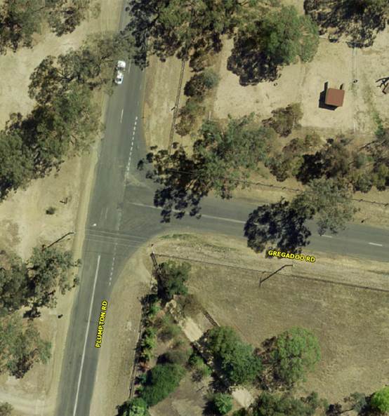
RP-2 GREGADOO ROAD AND PLUMPTON ROAD INTERSECTION - PROPOSED TREATMENT
Author: Fenwick, Alex
General Manager: Eldridge, Alan
|
That Council receive and note the contents of this report and accept the recommendation of Traffic Committee. |
Report
At the April 2016 Policy and Strategy Committee meeting the following was resolved:
That Council:
a receive and note the minutes from the Traffic Committee meeting held 10 March 2016, including a summary of each item’s risk and budget implications
b receive a further report on the details of RP-14, RP-20, RP-21 and RP-22 before a determination is made on these particular items
On 10 March 2016 the Traffic Committee made the following recommendation in respect to RP-14 GREGADOO ROAD AND PLUMPTON ROAD INTERSECTION - PROPOSED TREATMENT
That Traffic Committee endorse
a The design and installation of an auxiliary right turn treatment for north bound traffic on Plumpton Road at the intersection with Gregadoo Road
b The design and installation of 50 metres of left turn lane for west bound traffic in Gregadoo Road at the approach to the intersection with Plumpton Road
Traffic Committee received a report at its meeting on 16 March 2015 on the intersection of Gregadoo Road and Plumpton Road. The following recommendation was made:
That Traffic Committee endorse:
a The design and installation of a temporary auxiliary right turn facility in Plumpton Road at the intersection with Gregadoo Road
b The design and installation of nominally 50 metres of left turn lane in Gregadoo Road for west bound traffic
c That a study be made of the results of increased traffic movements in the area between Plumpton Road and Mitchell Road, south of Lake Albert, with particular consideration given to appropriate treatments for intersections that have reached, or will soon reach, an unacceptable level of service during morning and afternoon peak periods.
A further investigation has been made in respect of the intersection of Plumpton Road and Gregadoo Road. Observations have been made during the morning peak between 8:00am and 9:00am.
The issue that is regularly raised by drivers who use the intersection is the delay that is caused to drivers that are travelling west in Gregadoo Road, waiting to turn either left or right at Plumpton Road.
The longest delay that was observed during the course of observations was 145 seconds (2’ 25”) with an average delay of 25 seconds. Based upon the standard that is suggested in Table 4.2 of the Guide to Traffic Generating Developments, a delay of 25 seconds at such an intersection constitutes Level of Service B which is described as ‘Acceptable delays and spare capacity’.
.
Anecdotal evidence from daily users of the intersection suggest that the delays that far exceed those that were observed do occur, particularly on wet mornings.
One issue that did become apparent during the course of observations was the regular overtaking of vehicles that were turning right from Plumpton Road into Gregadoo Road by north bound vehicles that were continuing straight on in Plumpton Road. The north bound lane of Plumpton Road on the approach to the intersection is about 4.5 metres wide. Overtaking on the near side of right turning vehicles causes drivers to have their nearside wheels on the unsealed western shoulder of Plumpton Road. That shoulder suffers from this use.
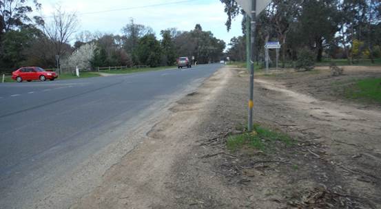
The creation of an auxiliary right turn treatment at this point would greatly improve safety aspects for drivers that are travelling straight through on Plumpton Road.
A significant number of drivers that are travelling west in Gregadoo Road were observed to turn left onto Plumpton Road. In many instances those drivers were unnecessarily delayed in the line of vehicles that were waiting to turn right. Construction of an auxiliary left turn treatment at the intersection for Gregadoo Road traffic would improve the efficiency of the road network in this area.
At the April 2016 Policy and Strategy Committee meeting, Councillors requested advice in relation to Section 94 funding for the intersection of Plumpton Road and Gregadoo Road. There are no projects identified in the current Section 94 Plan addressing the intersection of Plumpton Road and Gregadoo Road. Any future subdivisions in Lake Albert south of Gregadoo Road or the intensification of Springvale south of Tatton, could conceivably be charged for recoupment under either Section 94 or Section 94A if the intersection was upgraded to such a standard to cater for future population growth.
Budget
The cost of implementation of a treatment for this location cannot be estimated until such time as a treatment option is selected and a detailed design is prepared.
Policy
N/A
Impact on Public Utilities
N/A
Link to Strategic Plan
2. We are a safe and healthy community
2.1 We live in a safe community
QBL Analysis
|
|
Positive |
Negative |
|
Social |
Continued improvement to the community’s ability to travel across the Local Government Area in safety. |
N/A |
|
Environmental |
N/A |
N/A |
|
Economic |
Improved management of public spending on transport management. |
N/A |
|
Governance |
Responsible consultation and management of the Local Traffic Committee by Council. |
N/A |
Risk Management and Work Health and Safety Issues for Council
The intended purpose of this report is to safely manage a risk issue that has been identified and that is detailed in the report.
Internal / External Consultation
Consultation was undertaken with many road users who have contacted Council Officers with complaints about undue delays at this intersection.
Report submitted to the Ordinary Meeting of Council on Monday 25 July 2016. RP-3
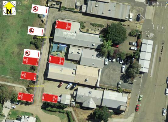
RP-3 GRAY'S LANE PARKING CONTROLS
Author: Fenwick, Alex
General Manager: Eldridge, Alan
|
That Council receive and note the contents of this report and accept the recommendation of Traffic Committee. |
Report
At the April 2016 Policy and Strategy Committee meeting the following was resolved:
That Council:
a receive and note the minutes from the Traffic Committee meeting held 10 March 2016, including a summary of each item’s risk and budget implications
b receive a further report on the details of RP-14, RP-20, RP-21 and RP-22 before a determination is made on these particular items
On the 10 March 2016 Traffic Committee made the following recommendation in respect to RP-20 GRAY'S LANE PARKING CONTROLS
That Traffic Committee endorse:
a Installation of a NO STOPPING zone, using standard R5-400 signs, for the full length of the eastern side of Gray’s Lane where that lane is adjacent to the eastern boundary of South Wagga Wagga Public School.
b Installation of a 35 metre long length of NO PARKING zone, using standard R5-40 signs, on the western side of Gray’s Lane, from the northern right angle bend in the lane, toward the south.
c Installation of a 32 metre long length of NO STOPPING zone, using standard R5-400 signs, on the western side of Gray’s Lane, from the southern end of the zone that is mentioned at point ‘b’ and extending to the southern end of the lane.
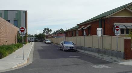
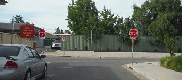
Gray’s Lane is a cul-de-sac, intersecting with Station Place. The original purpose of the lane was to provide access to the Station Master’s residence which is located at the extreme southern end. The eastern boundary of South Wagga Wagga Public School follows the western side of the lane. Gray’s Lane now also provides access to several properties that front to Station Place.
Gray’s Lane is used by parents and carers who are dropping and picking up children before and after school. The parents drive into the lane which has a trafficable width of less than five (5) metres. Vehicles in the lane for this purpose have caused serious access problems for businesses that use the lane to reach their respective properties. This matter has previously been reported to Traffic Committee vide RP-5 on 9 September 2014 and RP-4 on 16 July 2015. NO STOPPING parking control signs have been installed on both sides of the east-west section of the lane on the end nearest to Station Place.
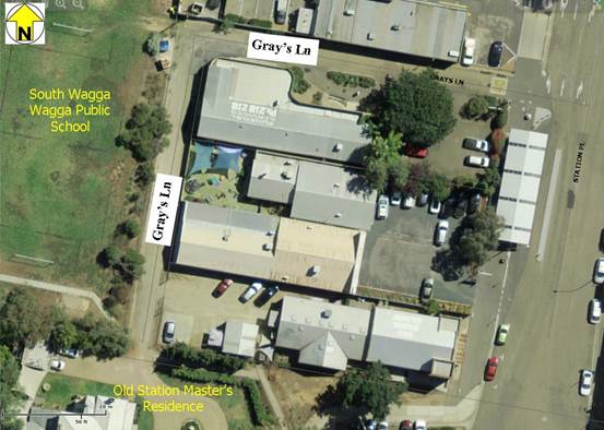
The historic nature of Gray’s Lane has resulted in the situation where there is no turning head at the southern end. Drivers who are dropping or picking up children enter onto private land to turn around because the width of the lane does not allow for any other option for forward movement. Drivers have also been seen to reverse their vehicles for the full length of the lane. Using the private car park at the southern end of the lane to turn around is regularly done contrary to a direction by the property owner that is displayed on the property fence.
A recommendation to create a turning head at the southern end of Gray’s Lane has been explored. That option would require conversion of a portion of the South Wagga Wagga Public School playground to road reserve, as previously reported on 16 July 2015. That option was not palatable to the School and has been dismissed as an option.
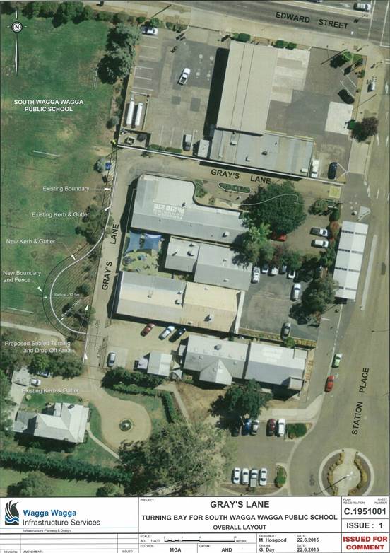
Other options for the provision of a pickup and drop-off location have been explored with the most suitable option being for parents and carers to park on the southern side of the railway line and walk children over the footbridge that connects to Station Place.
In an effort to maintain access for land occupiers that are adjacent to Gray’s Lane, it is recommended that the full length of the eastern side of the lane be controlled by NO STOPPING signs. The western side of the lane may be split with the southern end being NO STOPPING zone and the northern end being NO PARKING zone. The latter will allow for waste pickup from the school which is also accomplished from Gray’s Lane.
Budget
Estimated cost of implementing this initiative $1,500. The works are to be funded from the Lines and Signs Maintenance budget.
|
Total Budget Funding Sources |
Existing Budget |
Expenditure to Date |
Proposed Budget Variation |
Total Proposed Budget ($) |
|
Lines and Signs Maintenance |
372,537 |
0 |
0 |
372,537 |
Policy
N/A
Impact on Public Utilities
N/A
Link to Strategic Plan
2. We are a safe and healthy community
2.1 We live in a safe community
QBL Analysis
|
|
Positive |
Negative |
|
Social |
Continued improvement to the community’s ability to travel across the Local Government Area in safety. |
N/A |
|
Environmental |
N/A |
N/A |
|
Economic |
Improved management of public spending on transport management. |
N/A |
|
Governance |
Responsible consultation and management of the Local Traffic Committee by Council. |
N/A |
Risk Management and Work Health and Safety Issues for Council
The intended purpose of this report is to safely manage a risk issue that has been identified and that is detailed in the report.
Internal / External Consultation
Consultation was undertaken with adjacent land occupiers and also with the South Wagga Wagga Public School Principal
Report submitted to the Ordinary Meeting of Council on Monday 25 July 2016. RP-4
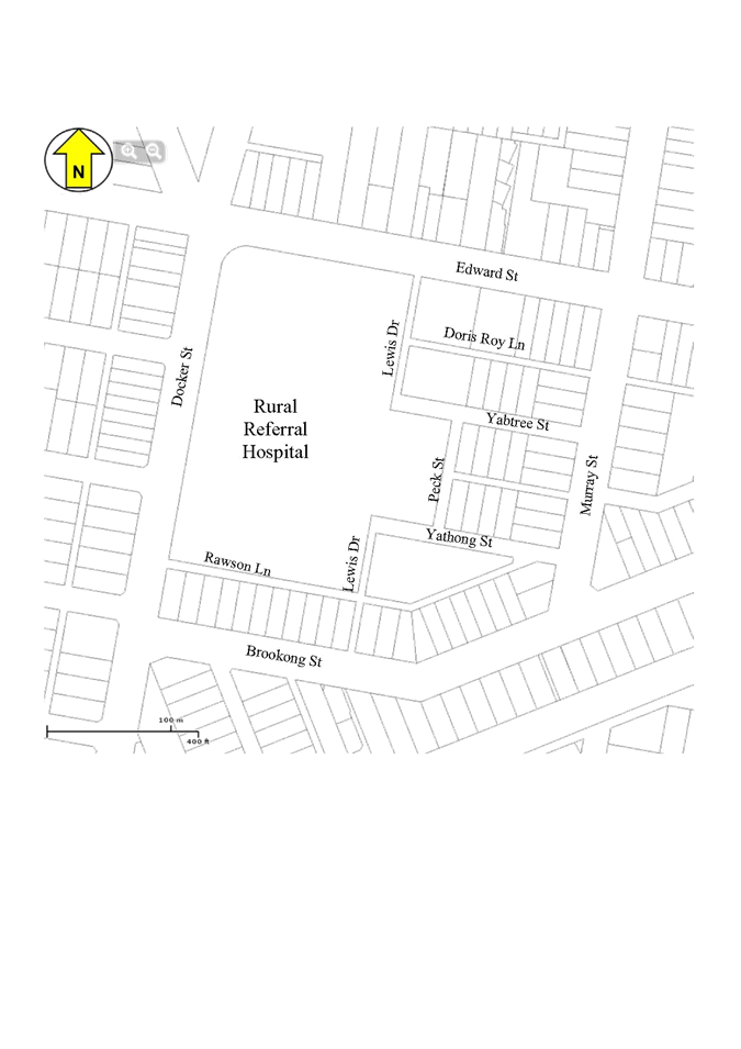
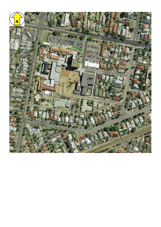
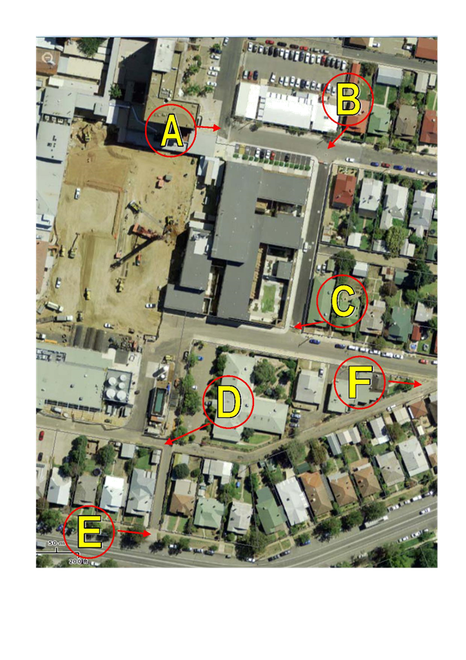
RP-4 HOSPITAL PRECINCT TRAFFIC AND PARKING MANAGEMENT
Author: Fenwick, Alex
General Manager: Eldridge, Alan
|
That Council receive and note the content of this report and accept the recommendation of Traffic Committee. |
Report
At the April 2016 Policy and Strategy meeting the following was resolved:
That Council:
a receive and note the minutes from the Traffic Committee meeting held 10 March 2016, including a summary of each item’s risk and budget implications
b receive a further report on the details of RP-14, RP-20, RP-21 and RP-22 before a determination is made on these particular items
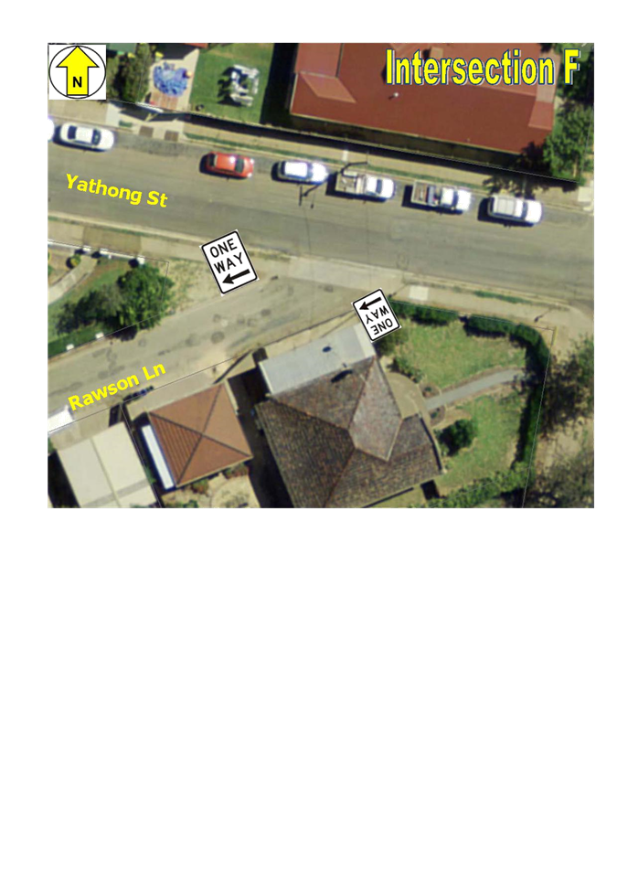
On the 10 March 2016 Traffic Committee made the following recommendation in respect to RP-21 HOSPITAL PRECINCT TRAFFIC MANAGEMENT – LEWIS DRIVE, YABTREE STREET, PECK STREET, YATHONG STREET AND RAWSON LANE
That Traffic Committee endorse the following actions on streets around the Wagga Wagga Rural Referral Hospital:
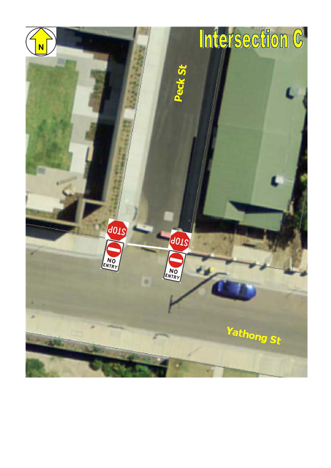
a Install duplicate ‘A’ size R2-4 NO ENTRY signs at the southern end of Peck Street facing into the intersection with Yathong Street.
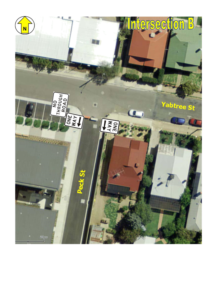
b Install duplicated ‘A’ size R2-2 ONE WAY signs on both sides at the northern end of Peck Street.
c Install duplicated ‘A’ size R1-1 STOP signs at the south end of Peck Street facing traffic travelling south in Peck Street.
d Install a corresponding TF (STOP) line, as per the provisions of Section 6.2 of the Roads and Maritime Services Delineation instructions, across Peck Street in conjunction with the STOP signs mentioned at point ‘c’.
e Remove the duplicated R2-4 NO ENTRY sign and the associated plate with the words ‘Emergency Vehicles Only’ plate from both sides of Yabtree Street immediately on the western side of the intersection with Peck Street.
f The G9-18 NO THROUGH ROAD sign that is on the southern side of Yabtree Street on the same pole as the signs mentioned at point ‘e’ is to remain in place. Any similar sign on the northern side of Yabtree Street should be removed.
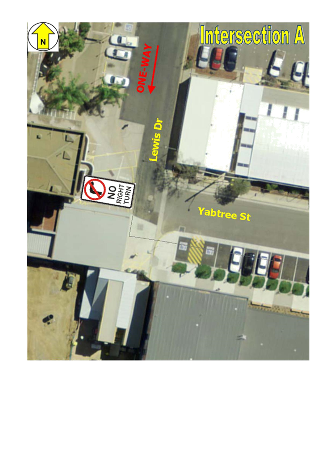
g Install a ‘B’ size R2-6(R) NO RIGHT TURN sign on the western side of Lewis Drive immediately opposite the intersection with Yabtree Street and facing traffic travelling west in Yabtree Street.
h Remove any sign that may be in place on the section of Lewis Drive that is between Yathong Street and Brookong Avenue that indicates that Lewis Drive is subject to a ONE-WAY traffic control.
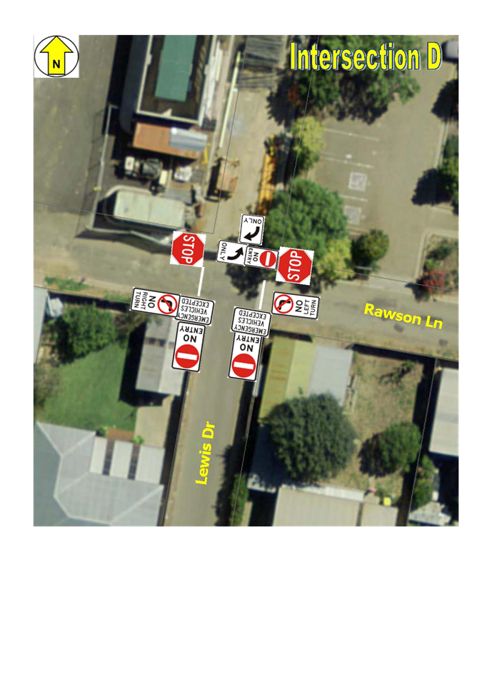
i Install duplicated ‘B’ size R2-4 NO ENTRY signs with an additional R9-200 plate that displays the words ‘Emergency Vehicles Excepted’ immediately underneath, on both sides of Lewis Drive on the southern side of the intersection with Rawson Lane facing traffic that is travelling south in Lewis Drive.
j Install duplicated ‘B’ size R2-4 NO ENTRY signs with an additional R9-200 plate that displays the words ‘Emergency Vehicles Excepted’ immediately underneath, on both sides of Lewis Drive on the northern side of the intersection with Brookong Avenue, facing traffic that may turn into Lewis Drive from Brookong Avenue.
k That Wagga Wagga City Council write to Roads and Maritime Services seeking approval to use R9-200 plates, in circumstances as mentioned at points ‘i’ and ‘j’.
l Install a ‘B’ size R2-14(R) (All Traffic Right) ONLY sign on the north-east corner of the intersection of Lewis Drive and Rawson Lane, facing traffic travelling south in Lewis Drive.
m Install duplicated R2-2 series ONE-WAY signs on both sides of the eastern end of Rawson Lane at the intersection with Yathong Street.
n Install a single ‘A’ size R2-4 NO ENTRY sign on the north-east corner of the intersection of Rawson Lane and Lewis Drive, facing east bound traffic in Rawson Lane.
o Immediately under the sign that is mentioned at point ‘n’ install an ‘A’ size R2-14(L) (All Traffic Left) ONLY sign, also facing east bound traffic in Rawson Lane.
p Remove the existing GIVE WAY sign control that is on the south-east corner of the intersection of Rawson Lane and Lewis Drive, facing traffic that is travelling west in Rawson Lane.
q Install a single ‘B’ size R1-1 STOP sign on the north-east corner of the intersection of Rawson Lane and Lewis Drive, facing traffic that is travelling west in Rawson Lane.
r Install a corresponding TF (STOP) line as per the provisions of Section 6.2 of the Roads and Maritime Services Delineation instructions across Rawson Lane in conjunction with the STOP signs mentioned at point ‘q’.
s Install a single ‘B’ size R1-1 STOP sign on the north-west corner of the intersection of Rawson Lane and Lewis Drive, facing traffic that is travelling east in Rawson Lane.
t Install a corresponding TF (STOP) line as per the provisions of Section 6.2 of the Roads and Maritime Services Delineation instructions across Rawson Lane in conjunction with the STOP signs mentioned at point ‘s’.
u Install an ‘A’ size R2-6(L) NO LEFT TURN sign on the south-east corner of the intersection of Rawson Lane and Lewis Drive, facing traffic that is travelling west in Rawson Lane.
v Install an ‘A’ size R2-6(R) NO RIGHT TURN sign on the south-west corner of the intersection of Rawson Lane and Lewis Drive, facing traffic that is travelling east in Rawson Lane.
Report
An extraordinary meeting of the Traffic Committee was held at Wagga Wagga on 11 October 2011 where a number of issues that related to the impending redevelopment of the Wagga Wagga Base Hospital were considered. In all, seven (7) separate reports were considered with recommendations made to Council on each matter.
Significant changes occurred during the hospital redevelopment project that have rendered three (3) of the recommendations that were made as not necessarily in the best interest of traffic management in the Health Precinct. In addition, a number of other matters have arisen which also require consideration.
Peck Street
At the meeting on 11 October 2011 a recommendation was made pursuant to RP-3 that the new section of Lewis Drive, which is now known as Peck Street, should be 7.5 metres wide with a footpath on the western side and a narrow nature strip on the eastern side. Traffic was expected to flow in both directions.
The evolution of traffic management around the hospital has caused necessary change, particularly with Ambulance vehicles being received on the southern side of the Emergency Unit which is contrary to the plan that was available for consideration in 2011. In that earlier plan, Ambulance vehicles were to be received on the northern side of the Emergency Unit. The nature of traffic management in streets around the hospital has resulted in an improved access route for Ambulances now using Brookong Avenue and the southern end of Lewis Drive.
There is no longer a need for Peck Street to be a two-way thoroughfare. Road safety around the hospital precinct is enhanced by limiting Peck Street to one-way movement with parked vehicles on one side, providing a traffic calming effect.
Traffic controls that are required in Peck Street to confirm the ONE-WAY nature of the street since its transfer to Council’s control are:
1. Installation of duplicated ‘A’ size R2-4 series NO ENTRY signs on both sides of the extreme southern end of Peck Street, facing into the intersection with Yathong Street. See intersection map C, attached.
Peck St - view north from Yathong Street
2. Installation of duplicated ‘A’ size R2-2 ONE-WAY signs on both sides of the extreme northern end of Peck Street. See intersection map B, attached.

R2-2 Sign
3. Sight distance at the southern end of Peck Street is restricted by a fence on the eastern side.
Peck Street intersection with Yathong Street
Duplicated ‘A’ size R1-1 STOP signs have been installed and should be authorised to remain in that position. Those signs should be supported by marking a STOP line on Peck Street across the intersection. See intersection map C, attached.
Hospital Precinct Speed Limit
This matter was considered at RP-6 on 11 October 2011. The matter is still the subject of consideration and negotiation with Roads and Maritime Services.
Lewis Drive, from the intersection with Edward Street to the intersection with Yabtree Street, remains one-way north to south.
Recent Issues
Yabtree Street Access
Yabtree Street has become a two-way street. While construction was being undertaken, including the Emergency Unit Ambulance access bays being located opposite the western end of Yabtree Street, access to the part of Yabtree Street that is west of the intersection with Peck Street was restricted by sign to emergency vehicles only.
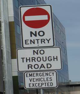
Signs currently in Yabtree Street immediately west of Peck Street
There is no longer a need to restrict west bound vehicles at this point. Vehicles should be permitted to access parking that is adjacent to the Mental Health Unit, immediately on the western side of the existing signs. Access to the Patient Transport Unit can also be gained by turning left at the western end of Yabtree Street onto a private driveway that is part of the hospital. The existing duplicated signs should be removed. A single G9-18 NO THROUGH ROAD sign should be left in place on the south-west corner to indicate that there is no access to the broader road network from the western end of Yabtree Street. See intersection map B.
A ‘B’ size R2-6(R) NO RIGHT TURN sign should be located on the western side of Lewis Drive immediately opposite the intersection with Yabtree Street and facing west bound traffic in Yabtree Street. A right turn at that point would see traffic travelling contrary to the ONE-WAY control in Lewis Drive. It is recommended that a sign of a larger size than normal be used in this location in an effort to stop drivers from turning right at the intersection, directly into the path of oncoming traffic on a section of Lewis Drive that is a ONE-WAY thoroughfare, north to south. See intersection map A.
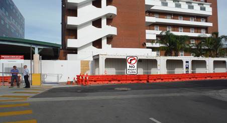
Yabtree Street - view to west end intersection with Lewis Drive
Lewis Drive – Southern End
The southern section of Lewis Drive between intersection with Yathong Street and Brookong Avenue has always been a ONE-WAY street, north to south. The operation of the Emergency Unit requires that Ambulance vehicles be able to access the unloading bays by travelling north in Lewis Drive.
The section of Lewis Drive between Yathong Street and Rawson Lane is about 7.5 metres wide which is sufficient to accommodate two-way traffic provided that there are no vehicles parked adjacent to either kerb. Parking restrictions in Lewis Drive between Yathong Street and Brookong Avenue are dealt with in a separate report.
The section of Lewis Drive that is between Rawson Lane and Brookong Avenue is about four metres wide. That section is only 40 metres long. It is proposed that vehicular traffic in that section be restricted to use by emergency vehicles only. Ambulance vehicles that are intending to use that southern end of Lewis Drive will co-ordinate with each other using their radio network. Other emergency service vehicles that may need to use that section of Lewis Drive under extreme circumstances will approach the section using appropriate warning devices.
It is recommended that any sign that indicates that this southern section of Lewis Drive is restricted to one-way flow should be removed.
Duplicated ‘B’ size R2-4 ‘NO ENTRY’ signs with additional R9-200 plates that display the words ‘Emergency Vehicles Excepted’ should be installed at the southern end of Lewis Drive, facing out to the intersection with Brookong Avenue. See intersection map E. The same signs and additional plate should be installed on both sides of Lewis Drive, facing south bound vehicles, immediately on the southern side of the intersection with Rawson Lane. See intersection map D. It is imperative that use of this section of Lewis Drive be restricted to emergency vehicles. For this reason it is recommended that the increased sign size be used.

R2-4 + R9-200 Sign Combination
Final approval for the use of R9-200 plates that display the words ‘Emergency Vehicles Excepted’ may only be granted by the Traffic Management Branch of Roads and Maritime Services.
A further ‘B’ size R2-14(R) ‘(All traffic right) ONLY’ sign should be installed on the north-east corner of the intersection of Lewis Drive and Rawson Lane, facing south bound traffic in Lewis Drive. This sign is to insure that drivers do not turn left into Rawson Lane, contrary to a ONE-WAY control, east to west, on the eastern end of Rawson Lane between Yathong Street and Lewis Drive. See intersection map D.

R2-14(R) Sign
The concept that the southern end of Lewis Drive is not for use by all south bound vehicles is a change to historical traffic control arrangements in the area. It is recommended that an increased size sign be used at this location to increase the likelihood of compliance.
Rawson Lane
The western end of Rawson Lane is now a two-way street from Docker Street to Lewis Drive. The eastern end of Rawson Lane between Lewis Drive and Yathong Street, is very narrow and only suitable for traffic travelling in one direction. The lane provides rear of block access for houses that face Brookong Avenue and also an entry to the Renal Unit car park. It is proposed that Duplicated ‘A’ size R2-2 series ONE-WAY signs be installed on both sides of Rawson Lane at the entry from Yathong Street. See intersection map F. It is further recommended that a single ‘A’ size R2-4 NO ENTRY sign should be installed on the north-east corner of Rawson Lane and Lewis Drive, facing traffic that is travelling east in Rawson Lane. See intersection map D. That sign should be accompanied by an ‘A’ size R2-14(L) (All Traffic Left) ONLY sign which should be located immediately under the NO ENTRY sign, also facing east bound traffic in Rawson Lane. See intersection map D.
Traffic travelling east and west in Rawson Lane have extremely poor sight distance toward the south at the intersection with Lewis Drive.
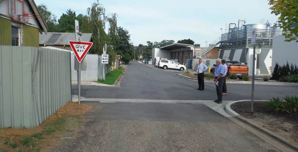
West bound view on Rawson Lane at Lewis Drive
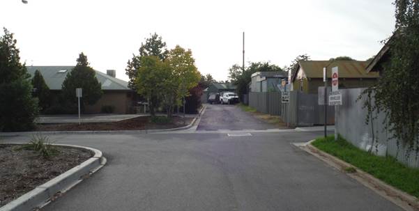
East bound view on Rawson Lane at Lewis Drive
The GIVE WAY control on the south-east corner should be removed. A single ‘B’ size R1-1 STOP sign should be installed on the north-east corner facing west bound traffic in Rawson Lane. A similar sign should be installed on the north-west corner facing east bound traffic in Rawson Lane. Corresponding STOP lines should be marked on Rawson Lane across the threshold of the intersection. It is recommended that, since only one (1) sign is being used in each instance, the sign should be of a larger size. See intersection map D.
A single ‘A’ size R2-6(L) NO LEFT TURN sign should be installed on the south-east corner facing traffic that is travelling west in Rawson Lane. A single ‘A’ size R2-6(R) NO RIGHT TURN sign should be installed on the south-west corner facing east bound traffic in Rawson Lane. These two (2) signs are calculated to stop drivers who might be intending to turn into the southern end of Lewis Drive that is now reserved for use by emergency vehicles only. See intersection map D.
On the 10 March 2016 Traffic Committee made the following recommendation in respect to RP-22 PARKING CONTROLS AROUND WAGGA WAGGA RURAL REFERRAL HOSPITAL - LEWIS DRIVE, PECK STREET AND YATHONG STREET
.
That Traffic Committee endorse the following actions in respect of parking controls on streets around Wagga Wagga Rural Referral Hospital:
a Install R5-400 series NO STOPPING signs on the western side of Peck Street for the full length from Yabtree Street to Yathong Street.
b Install an R5-400(L) NO STOPPING sign on the eastern side of Peck Street, 10 metres south of the intersection with Yabtree Street.
c Install R5-40 series NO PARKING signs, with additional words ‘Authorised Vehicles Excepted’, on the eastern side of Peck Street from the sign mentioned at point ‘b’ for a distance or 59 metres toward the south.
d Install R5-40 series NO PARKING signs, with additional words ‘Renal Patients Excepted’, on the eastern side of Peck Street, from the southern end of the zone that is mentioned at point ‘c’, for a length of 17 metres.
e No further action to be taken in respect of RP-5 from the minutes of the Traffic Committee meeting that was held on 11 October 2011 relating to the planning and establishment of centre of road parking in Brookong Avenue and Murray Street.
f Install a 10 metre length of NO STOPPING zone, using a R5-400(R) sign at the northern kerb of Yathong Street immediately west of Peck Street.
g Install 43 metres of NO PARKING zone using standard R5-40 series signs with the additional words ‘Authorised Vehicles Excepted’, from immediately west of the zone that is mentioned at point ‘m’ to the western kerb alignment of the Lewis Drive.
h Review parking controls that are mentioned at points ‘c’ and ‘g’ after the old tower block is demolished and a new car park is constructed on that space
.
i Install R5-400 series NO STOPPING signs on both sides of Lewis Drive for the full length from the intersection with Yathong Street to the intersection with Brookong Avenue.
An extraordinary meeting of the Traffic Committee was held at Wagga Wagga on 11 October 2011 where a number of issues that related to the impending redevelopment of the Wagga Wagga Base Hospital were considered. In all, seven (7) separate reports were considered with recommendations made to Council on each matter.
Significant changes occurred during the hospital redevelopment project that have rendered three (3) of the recommendations that were made as not necessarily in the best interest of traffic management in the Health Precinct. In addition, a number of other matters have arisen which also require consideration.
Peck Street
At the meeting on 11 October 2011 a recommendation was made pursuant to RP-3 that the new section of Lewis Drive, which is now known as Peck Street, should be 7.5 metres wide with a footpath on the western side and a narrow nature strip on the eastern side. Traffic was expected to flow in both directions. Both sides of the street were to be controlled by NO STOPPING controls using standard R5-400 series NO STOPPING signs. The evolution of traffic management around the hospital has caused necessary change, particularly with Ambulance vehicles being received on the southern side of the Emergency Unit which is contrary to the plan that was available for consideration in 2011. In that earlier plan, Ambulance vehicles were to be received on the northern side of the Emergency Unit. The nature of traffic management in streets around the hospital has resulted in an improved access route for Ambulances using Brookong Avenue and the southern end of Lewis Drive. There is no longer a need for Peck Street to be a two-way thoroughfare. Road safety around the hospital precinct is enhanced by limiting Peck Street to one-way movement with parked vehicles that provide a traffic calming effect.
Murrumbidgee Local Health District (MLHD) management had arranged with Wagga Wagga City Council (WWCC) for Peck Street to be opened for use with traffic restricted to a ONE-WAY flow, north to south, with NO STOPPING controls on the western side. The full length of the eastern side of Peck Street was subject to conditional permissive parking. The first 10 spaces from the northern end are sign posted as ‘PARKING/Authorised Vehicles Only’. Vehicles that were authorised to park in these spaces are all associated with MLHD or NSW Health. At this point in time Peck Street was still under control of MLHD and NSW Health and had not been transferred to the control of WWCC.
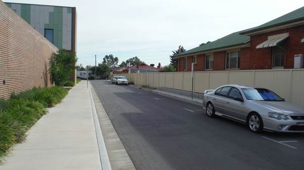
Peck Street - view from southern end
The remaining two (2) spaces are sign posted as ‘NO PARKING/Renal Patients Excepted’. A statutory length (10 metres) of NO STOPPING zone was imposed on the eastern side at the southern end of Peck Street.
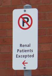
The Renal Unit is separate from the main hospital building, located in Yathong Street immediately opposite the intersection with Peck Street. The Renal Unit has been renovated and the parking layout, while providing the same number of spaces as before, is not as easy to use by some elderly patients. Retaining these spaces has proven to be of great assistance to many patients. Able-bodied staff park off-site, not within the Renal Unit parking area.
The ONE-WAY nature of Peck Street allows parking to be extended adjacent to the eastern kerb closer to the intersection with Yathong Street. There is no need for the statutory 10 metre length of NO STOPPING zone to be imposed as traffic is not permitted to turn into Peck Street from Yathong Street. The length should be shortened to six (6) metres using an appropriate sign if the recommendation is adopted.
MLHD have requested that the parking controls, described above, that were implemented before the street was transferred to Council’s control be permitted to remain in place thereby providing preferential parking in favour of MLHD and NSW Health vehicles and patients of the Renal Unit. This arrangement should be reviewed once the old tower block is demolished and a new ground level car park is established in that space.
A separate report deals with the retention of Peck Street as a ONE-WAY Street and the appropriate controls to manage that option.
Brookong Avenue and Murray Street – Centre of Road Parking
This matter was dealt with as RP-5 on 11 October 2011. That recommendation was that a centre of road parking scheme be designed for Brookong Avenue and the southern end of Murray Street. Subsequent investigation of available space and the requirements for such a scheme, that are detailed in Australian Standard 2890 revealed that such a scheme could not be introduced in the width of seal between kerbs. The recommendation was not implemented.
Yathong Street Parking
The northern side of the section of Yathong Street that is between Peck Street and Lewis Drive has been subject to ‘NO PARKING/Construction Vehicles Excepted’ controls since that section of street was completed as part of the redevelopment project. That control is no longer required. The whole length is 53 metres, accommodating about six (6) vehicles. The statutory 10m length of NO STOPPING zone on the western side of the intersection with Peck Street should be supported with a single R5-400(R) NO STOPPING sign located at the northern kerb of Yathong Street, 10 metres west of the intersection with Peck Street.
The remaining 43 metres of kerb in this section on the northern side of Yathong Street should remain NO PARKING zone. MLHD had requested that the length be changed to ‘NO PARKING/Authorised Vehicles Excepted’.
MLHD wish to negotiate with WWCC to define vehicles that are authorised to park in this area as well as Peck Street. Proximity to the Ambulance entrance into the Emergency Unit suggests that Authorised Vehicles should include Emergency Services vehicles.
Lewis Drive – Southern End
The section of Lewis Drive between Yathong Street and Rawson Lane is about 7.5 metres wide which is sufficient to accommodate two-way traffic provided that there are no vehicles parked adjacent to either kerb. Parking on this section of Lewis Drive was previously restricted by NO PARKING controls but they have been removed. The section of Lewis Drive that is between Rawson Lane and Brookong Avenue is about four metres wide. That section is 40 metres long. The proposed operation of traffic in the southern end of Lewis Drive is dealt with by separate report.
It is recommended that the full length of both the eastern and western kerbs from the intersection with Yathong Street to the intersection with Brookong Avenue should be controlled by standard R5-400 series NO STOPPING signs.
Budget
Estimated cost of implementing these initiatives $6,900. The works are to be funded from the Lines and Signs Maintenance budget.
|
Total Budget Funding Sources |
Existing Budget |
Expenditure to Date |
Proposed Budget Variation |
Total Proposed Budget ($) |
|
Lines and Signs Maintenance |
372,537 |
0 |
0 |
372,537 |
Policy
N/A
Impact on Public Utilities
N/A
Link to Strategic Plan
2. We are a safe and healthy community
2.1 We live in a safe community
QBL Analysis
|
|
Positive |
Negative |
|
Social |
Continued improvement to the community’s ability to travel across the Local Government Area in safety. |
N/A |
|
Environmental |
N/A |
N/A |
|
Economic |
Improved management of public spending on transport management. |
N/A |
|
Governance |
Responsible consultation and management of the Local Traffic Committee by Council. |
N/A |
Risk Management and Work Health and Safety Issues for Council
The purpose of these recommendations is to reduce the risk to road users in the area around the Hospital.
The purpose of these recommendations is to manage the risk of parked vehicles on streets around the Hospital.
Internal / External Consultation
Consultation was undertaken with Murrumbidgee Local Health District Management staff and with Emergency Service providers.
|
1⇩. |
Hospital Precinct Maps |
|
RP-5 MAJOR EVENTS SPONSORSHIP FUND
Author: Nolan, Sally
Director: Bolton, James
|
That Council: a note that two (2) applications for Major Events Sponsorship have been received from; from the Rotary Club of Wollundry Wagga Wagga, for the 2016 Gears and Beers Festival and the 2016 Spring Street Festival b approve Major Events Sponsorship for the following events: · 2016 Gears and Beers Festival 2 October - $20,000 · 2016 Spring Street Festival 17 September - $8,000 |
Report
Council is in receipt of two (2) applications from the 2016/2017 Major Events Sponsorship budget. The applications are from the Rotary Club of Wollundry Wagga Wagga for their 2016 Gears and Beers Festival and Riverina Event Solutions for the 2016 Spring Street Festival.
Gears and Beers - First held in 2014 with the second event in 2015 experiencing an increase of close to 180% in rider participation and over 3,500 people attending the festival.
Sponsorship for this event has been requested to further stimulate tourism and economic activity, to increase State, National and International exposure of Wagga Wagga by increasing advertising and promotion of this event. If this application is successful Wagga Wagga City Council will be acknowledged as one of the Major Sponsors (Yellow Jersey) and Council’s branding will be used on promotional material, on TV and print media.
Spring Street Festival - is a one-day free community event held in the heart of Wagga Wagga. Based on the region, for the region, the festival has a program that has something for everyone from spring workshops, cooking demonstrations, live music and kid’s entertainment.
Sponsorship for this event has been requested to assist in additional advertising of the event and the introduction of a new children’s interactive area and roving entertainment for children. If this application is successful Wagga Wagga City Council and its branding will be acknowledged on all promotional material.
These two (2) events will stimulate the local economy and attract local, state and international (Gears and Beers) recognition for Wagga Wagga and provide a social benefit to the community. Businesses likely to benefit directly from these events include accommodation establishments, restaurants, cafes, equipment hire companies, local food suppliers, entertainers and transport providers. Indirect benefits will also have a flow on effect to the broader economy.
Applications for sponsorship will be considered in line with the following:
Eligibility for funding under Policy POL 087 - Major Events Sponsorship - Criteria for funding
Major events which may attract sponsorship from a minimum of $5,000 (excluding GST) up to a maximum of $20,000 (excluding GST) per single event, must meet two or more of the following criteria and be held in the Wagga Wagga Local Government Area:
a) A minimum of 500 participants/competitors
b) A minimum of 1,000 visitors/spectators
c) Estimated economic benefit to the local economy from the event is in excess of $500,000
d) The event has the potential for significant state, national and/or international exposure, likely to result in increased visitation for the City.
Detailed report for Gears and Beers Festival - Event Organiser – Rotary Club of Wollundry Wagga Wagga
The 3rd annual Gears and Beers Festival is a Community Cycle Challenge, combined with a Craft Beer and Cider Festival. The event is run by a volunteer committee of the Rotary Club of Wollundry Wagga Wagga. The in-kind value of the contribution from the members of Rotary in running this event is conservatively $17,000. Without this assistance, the event would not be able to run as efficiently and effectively as it has in the past two (2) years. The focus of the event is on community participation mums, dads, children, current cycle enthusiasts, beginners and business challenge participants. This year, the combination of the cycle challenge, the craft beers and cider, outstanding locally roasted coffee, accompanied by great local food plus first class musical entertainment should make for another enjoyable afternoon.
The Gears and Beers inaugural event was held in 2014, with 430 riders. In 2015 participant numbers increased to 760. In 2016 it is anticipated that 1,400 riders will register to participate in this event. The festival side of the event attracted approximately 3,500 people in 2015 and is also expected to grow in 2016.
The Dirty 130 ride was introduced in 2015 and was a catalyst for attracting metropolitan based riders to Wagga Wagga. This ride is approximately 130kms of challenging rural riding with four “Dirt Sectors” each rated and named. This ride will also be included in the 2016 event.
In 2015, Gears and Beers gained National and International exposure due to its major partner Rapha (a world acclaimed cycling brand), posting images of the event via Instagram in the UK. Rapha have a huge social media following and the 2016 event will see many cycling enthusiasts riding from Melbourne, Canberra and Sydney to Wagga Wagga to participate in the cycling events, in particular, The Dirty 130.
The 2015 event was advertised on cycling event websites throughout Australia and the event attracted personalities like multiple Olympic gold medallist Drew Ginn who will attend the 2016 event, along with Beardy McBeardy (Marcus Enno) currently accredited photographer for the Giro d Italia 2016. Many sporting identities have also indicated that they will be attending the 2016 event.
The 2016 Gears and Beers Festival was launched at a Rapha function in Melbourne on Wednesday 13 July 201.
This is the first request for Major Event Sponsorship and would be utilised to promote this event nationally and internationally via branding of the event, the production of postcards, posters, advertising via newspapers, magazines, radio and television, photography, web – blog posts, Facebook and Instagram. The organisers of this event are committed to undertaking research surveys with participants that can provide information to be used to grow this event into an extended program over the long weekend in October and in turn provide longer visitor stay and increased expenditure within the city.
Detailed report for The Spring Street Festival – Event Organiser – Riverina Event Solutions Pty Ltd – Alexandra Mack
The 2016 Spring Street Festival will be a Street Festival celebrating spring, local produce and promoting community interaction. Entry to the event is free of charge with a gold coin donation going to a local charity.
There will be over 30 stalls selling a variety of food and drink promoting the best of the Riverina region. The 2016 event will see new stalls coming on board as well as interactive areas through the event site from lawn games to roving entertainment. This is a one-day free community event, held in the heart of Wagga Wagga.
Surveys were undertaken at the 2015 event and visitors came from the Riverina, NSW, ACT, Victoria, South Australian and Western Australia. Approximately 5,000 people attended this event with a large percentage of family with children. A number of the attendees who were interviewed, indicated that they were stopping over in Wagga Wagga on their way to the Henty Field Days the following week or had attended Ag Day Races.
As a recipient of Major Event Sponsorship in 2015, Wagga Wagga City Council’s support was acknowledged on social media – Facebook and Instagram, newspaper articles, A4 poster, TV advertising and the large screen in the Victory Memorial Gardens on the day of the event. This event also received positive media coverage post event outside the Wagga Local Government Area.
Budget
The Major Events Sponsorship budget is $100,000. There are no commitments for the 2016/2017 budget period.
The existing budget for Major Event Sponsorship is adequate to fund the proposed sponsorship amounts of $28,000 contained in the recommendation of this report. This would leave $72,000 in the Major Events Sponsorship budget for future request.
|
Project Name & Component |
Existing Budget |
Expenditure to Date |
Proposed Budget Variation |
Effect on LTFP
|
|
Major Events |
$100,000 |
Nil |
Nil |
Nil |
|
TOTALS |
$100,000 |
Nil |
Nil |
Nil |
Budget Summary
The Major Events annual budget is $100,000. This budget is able to fund the proposed sponsorship amounts of $28,000 (excluding GST) contained in the recommendation of this report.
Policy
POL 087 – Major Events Sponsorship Policy.
Impact on Public Utilities
N/A
Link to Strategic Plan
1. We are an engaged and involved community
1.2 We have opportunities and places for connection
QBL Analysis
|
|
Positive |
Negative |
|
Social |
Will provide outcomes for the community as per Council’s Strategic Plans. |
N/A |
|
Environmental |
No evidence of major environmental impact from event listed in this report. |
N/A |
|
Economic |
Increased visitation to the city as a result of these events. |
N/A |
|
Governance |
N/A |
N/A |
Risk Management and Work Health and Safety Issues for Council
No specific issues identified.
Internal / External Consultation
Internal consultation with relevant staff to discuss applications.
External consultation with applicants for sponsorship.
Report submitted to the Ordinary Meeting of Council on Monday 25 July 2016. RP-6
RP-6 ANNUAL GRANTS PROGRAM 2016/2017
Author: Scully, Madeleine
Director: Summerhayes, Janice
|
That Council: a approve the successful applications from the assessment process for the 2016/2017 Annual Grants Program as detailed in the report b reallocate $13,900 out of the $15,440 unexpended funds from the Connected Rural and Urban Communities category in order to support the Downside Recreation Reserve & Public Hall Trust Mates and Great Covered BBQ Area. c reallocate the remaining $5,937 unexpended funds from the Connected Rural and Urban Communities category to Council’s rural halls maintenance budget for the 16/17 financial year d note and approve the budget variation/s as detailed in the budget section of the report |
Report
Council’s Annual Grants Program consists of six (6) grant categories: Community Health and Wellbeing, Connected Rural and Urban Communities, Arts and Culture, Local Heritage, Events and Sustainable Environments. The program offers the opportunity for individuals, community groups and organisations to apply for funding for a range of programs and activities across the Local Government Area. The total amount of funding available was $175,800. The grants application period opened on Monday 21 March 2016 and closed on Monday 31 May 2016.
A total of 105 applications were received worth $387,815, equating to a 19% increase on funding requests in 2015/2016. Applications were assessed by category specific panels comprising of a Councillor, Council staff and an independent external representatives. Out of the applications 71% have been partially or fully funded. A presentation evening for successful applicants has been planned to be held on 18 August 2016 at the Civic Theatre.
Sub Category – Recreational Facilities
Panel members were Councillor Yvonne Braid, Council officer Peter Cook (Recreation Officer) and Independent Community Representative, Luke Olsen (Development Manager, Cricket NSW). Fifteen applications were received, requesting a total of $88,607 with $30,000 available. Nine (9) applications were unsuccessful.
|
Organisation Name |
Project Description |
Funding Approved |
|
Installation of safety nets at the car park end of both synthetic fields.
|
$3,750
|
|
|
Construction of a retaining wall around the new transformer in the North/Eastern corner of McDonalds Park.
|
$6,000 |
|
|
Install new water line at property for off-leash area water supply.
|
$960
|
|
|
Mangoplah Cookardinia United Eastlakes Football & Netball Club Inc |
Upgrade to clubhouse: Strip back/ prepare & paint. Build veranda and veranda shelter.
|
$6,000 |
|
Water and sewer connection to the Quinty Mens Shed for future connection of toilets.
|
$6,000
|
|
|
Collingullie Glenfield Park Junior Football and Netball Club |
Lighting for new netball facility at Glenfield Oval. |
$7,290
|
|
TOTAL |
$30,000 |
Sub Category – Community Programs and Projects
Panel members were Councillor Dallas Tout, Council officer Victoria Lowe (Community Development Officer) and Independent Community Representative, John Pocius (Red Cross).
Twenty-one applications were received, requesting a total of $51,421 with $30,000 available. Eight (8) applications were unsuccessful. The total amount of unallocated funds was $0.
|
Organisation Name |
Project Description |
Funding Approved |
|
Purchase and maintain a portable oxygen machine suitable for children.
|
$3,333 |
|
|
Community Connectedness bus for the elderly.
|
$3,000 |
|
|
Monthly sports days (involving activities, games and try-days) to provide ways of motivating community members to stay healthy.
|
$1,710 |
|
|
Rashies for carers at camps so they are easily identifiable by children and staff during swimming excursions.
|
$1,765 |
|
|
|
Purchase three sets of hoops that can be adjusted to allow beginners to learn the game.
|
$1,618 |
|
CanTeen Awareness & Education Project in Wagga Wagga Schools: To educate students and staff about how to help support young people living with cancer.
|
$1,138 |
|
|
Purchase of equipment to improve result management at orienteering events. |
$1,010 |
|
|
‘Move it for Your Mind’: A health education and participation program that uses physical activity to support good mental health in women. |
$2,570 |
|
|
Serenity Garden: A project aimed at providing victims of domestic violence (women) at She Housing with a private and tranquil setting for reflection.
|
$3,000 |
|
|
Build a website for the Wagga Wagga Domestic Violence Liaison Committee. |
$3,000 |
|
|
Wagga Autism Support Group Incorporated
|
‘Sensory Santa Photo Shoot’: Created for families with special needs children that have sensory disorders and cannot have a regular 'Santa Photo' because of the sensory barrier. |
$3,000 |
|
A cricket program for children aged 8 – 13 years from refugee backgrounds run by Cricket NSW.
|
$1,856 |
|
|
"Grandparents Doing It Tough" (GDIT) Support Group - Centacare SW NSW
|
‘Grandparents Doing It Tough’: Support group community resource booklet for grandparents raising grandchildren. |
$3,000 |
|
TOTAL |
$30,000 |
Connected Rural and Urban Communities Grants
Sub Category – Neighbourhood and Rural Village
Panel members were Councillor Dallas Tout, Council officer Victoria Lowe (Community Development Officer) and Independent Community Representative, John Pocius (Red Cross).
Eight (8) applications were received, requesting a total of $20,603 with $22,000 available. One (1) application was unsuccessful. The total amount of unallocated funds is $4,397.
|
Organisation Name |
Project Description |
Funding Approved |
|
Revitalise North Wagga Playgroup venue so the group are able to continue regular visits.
|
$2866 |
|
|
|
Ladysmith P and C Duathlon 2016. |
$2662 |
|
|
Ngumba-dal (Unity)’: Provide program for children, staff and parents of Ashmont Preschool to connect with and develop relationships with the Hands on Weaver Inc. members from the Ngurra Hub next door to Ashmont Preschool. |
$3000 |
|
Support the establishment of the Humula Progress Association.
|
$1700 |
|
|
Humula Community Newsletter.
|
$1375 |
|
|
1st Wagga Wagga Scout Group – Kooringal
|
New Air Conditioning.
|
$3000 |
|
Tarcutta Progress Association
|
Tarcutta Community Newsletter. |
$3000 |
|
TOTAL |
$17,603 |
Sub Category – Rural Halls
Panel members were Councillor Yvonne Braid, Council officers Tony Powell (Facilities Management Coordinator) and Carly Hood (Environmental Coordinator) and Independent Community Representative, Raymond Birchall (Retired, NSW Police Force).
Four (4) applications were received, requesting a total of $28,766 with $25,000 available. Two (2) applications met the eligibility criteria. The total amount of unallocated funds is $15,440.
|
Organisation Name |
Project Description |
Funding Approved |
|
Mangain Community Centre Volunteers
|
Stage 1 Refurbishment of Toilet Block |
$6,910
|
|
Ganmain Gun Club |
Maintenance to club house |
$2,650
|
|
TOTAL |
$9,560 |
Arts and Culture
Panel Members were Councillor Dallas Tout, Council officer Tracie Miller (Cultural Officer) and Independent Community Representative, David Gilbey (Booranga Writers Centre).
Eighteen applications were received, requesting a total of $55,147 with $25,000 available. Six (6) applications were unsuccessful.
|
Organisation Name |
Project Description |
Funding Approved |
|
Culture Club
|
Cultural Delight and Flight: A series of activities involving henna and kites to encourage communities and individuals to connect.
|
$2,460 |
|
|
The Riverina Concert Band Professional Development and Performance Workshop. |
$2,000 |
|
|
‘Have Poets Left a Patch to Sew?’: A textile exhibition and seminar. |
$3,800 |
|
|
Author/illustrator talks to local primary schools about her picture book ‘Spring’. |
$1,400
|
|
Equipment and uniform upgrade. Much of the Pipe Bands equipment was destroyed in the floods.
|
$1,200 |
|
|
‘Re/creating: An exhibition featuring the work of 23 female Riverina based artists.
|
$4,000 |
|
|
|
The Extended Flute Workshop: a two-day workshop held at the Riverina Conservatorium of Music.
|
$1,840
|
|
|
To purchase the necessary equipment required for the courses being run or proposed to be run.
|
$1,239 |
|
|
‘Art For One Art For All’: A creative workshop aimed at developing social skills and community integration for people with a disability.
|
$2,000 |
|
|
Creating a new artwork to replace an existing artwork on the external wall of the Playsession Hall at the Botanic Gardens.
|
$2,900 |
|
Burmese Kachin Community of Wagga Wagga |
Purchase musical instruments to be used at events, activities and at our performances at local festivals and gatherings.
|
$1,000 |
|
Society for Creative Anachronism - Bordescros |
Purchase and decorate a Saxon trader's tent for group use, and tools for the manufacture of leather armour.
|
$1,161 |
|
TOTAL |
$25,000 |
Local Heritage
Panel Members were Councillor Yvonne Braid, Council officers Steven Cook (Town Planner) and Bryce Koop (Town Planner) and Independent Community Representative John Outram (Heritage Advisor).
Thirteen applications were received, requesting a total of $85,151 with $16,620 available. Five (5) applications were unsuccessful. The total amount of unallocated funds is $180.00.
|
Organisation Name |
Project Description |
Funding Approved |
|
External redecoration at 9 Roma Street Wagga Wagga.
|
$2,765 |
|
|
Remove paint from front brickwork at 121 Morgan Street Wagga Wagga.
|
$1,249 |
|
|
Repainting heritage façade at 129 Best Street. |
$1,900
|
|
|
Wagga Physio reinstatement of original heritage period colour scheme in conservation area at 45 Best Street.
|
$1,760 |
|
|
|
Preparation and repainting of exterior of dwelling at 109 Tompson Street. |
$2,500 |
|
Restoration of the World War 1 memorial/honour board at the Anglican Parish of Wagga Wagga
|
$3,000 |
|
|
|
Restoration of front fence at 12 Freer Street. |
$1,961 |
|
‘Send it Down Huey’: Remove and reinstall guttering down pipes from Downside Hall. Install rain water tank and pump.
|
$1,485 |
|
|
TOTAL |
$16,620 |
Events
Panel members were Councillor Yvonne Braid, Council officers Sally Nolan (Manager Events), Rachel Anderson (Visitor Economy Officer) and Cassie Nimmo (Event Coordinator) and Independent Community Representative, Josh Walsh (Managing Director, St Edwards of the Riverina)
Eighteen applications were received, requesting a total of $49,500 with $20,000 available. Four (4) applications were unsuccessful.
|
Organisation Name |
Project Description |
Funding Approved |
|
‘Riverina Truck Show and Kids Convoy’ charity fundraising event. |
$1,000 |
|
|
|
‘Farm Draft 2016’. An event to engage, educate and entertain people from both rural and metropolitan backgrounds. |
$2,000 |
|
|
‘The Fairway Dinner ‘An event to raise funds for the new Forrest Centre Hospice’. |
$1,000 |
|
CWA of NSW Riverina Group 90th Conference. |
$1,000 |
|
|
Cork & Fork Festival Event. |
$1,000 |
|
|
|
Speaker Spotlight Sessions: Sessions to showcase high profile people and make them accessible for people living in the City of Wagga Wagga. |
$1,000 |
|
Riverina All Schools MTB Challenge: The first all schools mountain biking race in this region, staged at Pomingalarna Reserve.
|
$2,950 |
|
|
Wagga Wagga Folk Society Inc. |
The 47th Uranquinty Folk Festival Youth Concert. |
$500 |
|
Wagga Wagga Athletics & Little Athletics |
Hosting 2017 Region 4 Little Athletics Championships Carnival. |
$3,000 |
|
Wagga City Rugby Male Choir Inc. |
Male Voice Choir Concert event in Wagga in October 2016. |
$1,000 |
|
Rural Appreciation Weekend
|
Rural Appreciation Weekend (RAW) 2016: Held in Wagga and Tarcutta this event showcases the Riverina to Australia’s future health workforce and to convey country hospitality and sense of community in rural towns like Tarcutta. |
$3,000 |
|
Wagga Wagga Fencing Club |
Riverina Fencing Championship September 2016 |
$550 |
|
Australian International Animation Festival (AIAF)
|
Australian International Animation Festival (AIAF): This event will be held at Forum 6, bringing the world's best animation to Wagga audiences. |
$1,500 |
|
Wagga International Jazz Day
|
Organise and produce an outstanding Jazz concert in Wagga Wagga for International Jazz Day. |
$500 |
|
TOTAL |
$20,000 |
Sustainable Environments
Panel members were Councillor Yvonne Braid, Council officers Tony Powell (Facilities Management Coordinator) and Carly Hood (Environmental Coordinator) and Independent Community Representative, Raymond Birchall (Retired, NSW Police Force)
Four (4) applications were received, requesting a total of $8,620 with $7,000 available. All applications were funded.
|
Organisation Name |
Project Description |
Funding Approved |
|
South Wagga Public School Garden: To create a vegetable garden with the purpose of reconnecting the students and wider school community with how food is grown and where it comes from.
|
$880 |
|
|
Develop the Wagga Flora Biodiversity information website to increase scale/scope in Flora Location Mapping. Funding will help develop flora location map at Willans Hill, where designated walks are geomapped to generate a digital information system to guide users on a series of biodiversity walks on site. |
$2,471 |
|
|
Kapooka Early Childhood Centre Inc
|
Kapooka Happy Hens: Purchase of six (6) hens and construction of the hen house. |
$1,263 |
|
Murrumbidgee Landcare inc |
Community Outdoor Cinema and BBQ Nights to help build profile of Landcare in the Wagga Wagga Local Government area?
|
$2,386 |
|
TOTAL |
$7,000 |
Budget
|
Description |
Total funds allocated |
Total Funds unallocated |
Total Budget |
|
Events |
$20,000 |
$0 |
$20,000 |
|
Natural Environments |
$7,000 |
$0 |
$7,000 |
|
Arts and Cultural |
$25,000 |
$0 |
$25,000 |
|
Local Heritage |
$16,620 |
$180 |
$16,800 |
|
Community Health and Wellbeing Grants |
|
|
|
|
Recreational Facilities |
$30,000 |
$0 |
$30,000 |
|
Community Programs and Projects |
$30,000 |
$0 |
$30,000 |
|
Connected Rural and Urban Communities |
|
|
|
|
Neighbourhood and Rural Village |
$17,603 |
$4,397 |
$22,000 |
|
Rural Halls |
$9,560 |
$15,440 |
$25,000 |
|
Total |
$155,783 |
$20,017 |
$175,800 |
|
Project Name & Component |
Existing Budget |
Expenditure to Date |
Proposed Budget Variation |
Effect on LTFP
|
|
Annual Grants Program 2016 - 2017 |
$175, 800 |
Nil |
Nil |
Nil |
|
TOTALS |
$175, 800 |
Nil |
Nil |
Nil |
|
Total Budget Funding Sources |
Existing Budget ($) |
Proposed Budget Variation ($) |
TOTAL PROPOSED BUDGET ($) |
|
WWCC Annual Grant Budget 2016/17 |
$175,800 |
Nil |
$175,800 |
|
TOTAL BUDGETED AMOUNT FOR PROJECT |
$175,800 |
Nil |
$175,800 |
Policy
POL 078 – Donations under Section 356 of the Local Government Act 1993.
Impact on Public Utilities
N/A
Link to Strategic Plan
1. We are an engaged and involved community
1.2 We have opportunities and places for connection
QBL Analysis
|
|
Positive |
Negative |
|
Social |
Assisting community groups to undertake projects that enhance community health and wellbeing. |
N/A |
|
Environmental |
Assisting community groups to lead sustainable environmental practices. |
N/A |
|
Economic |
Event and cultural activities achieving economic return for our community. |
N/A |
|
Governance |
A transparent process is in place to ensure the equitable distribution of funds through the grants process. |
N/A |
Risk Management and Work Health and Safety Issues for Council
No specific issues identified.
Internal / External Consultation
Extensive advertising and media communication was deployed for the annual grants including community engagement through two (2) Annual Grants workshops held on 6 April 2016 and 20 April 2016. Both workshops had record attendance from the community.
Report submitted to the Ordinary Meeting of Council on Monday 25 July 2016. RP-7
RP-7 2015/16 CARRYOVERS AND 30 JUNE 2016 INVESTMENT REPORT
Author: Rodney, Carolyn
Director: Richardson, Craig
|
That Council: a approve the 2015/16 project carryovers and reserve transfers as presented in this report b note the works in progress as presented in this report c note Council’s external investments as at 30 June 2016 |
Executive Summary
This report provides a summary of the 2015/16 capital works in progress and those projects which have not yet commenced as at 30 June 2016. The adoption of the recommendation will enable the revote of the funding allocation from the 2015/16 budget for projects that have not commenced to the 2016/17 budget. The estimated carryover figures that are presented in this report are subject to change pending the finalisation of the 2015/16 financial statements.
The report also highlights the various works in progress as at 30 June 2016 noting that the unexpended funds will automatically carryover to the 2016/17 financial year without the need for a Council resolution, as per regulation 211 of the Local Government (General) Regulation 2005.
This report also includes details on the performance of Council’s investments at 30 June 2016.
The normal monthly financial report is not included in this report due to the commencement of the year end process and preparation of the financial statements for auditing. The 2015/16 Financial Statements will be presented to Council in October 2016 which will highlight and provide analysis on Council’s overall financial performance and position for the 2015/16 financial year. Council’s Independent Auditor will present the 2015/16 Audit Report at the November 2016 Council meeting.
2015/16 Project Carryover Requests and Works in Progress
The attached tables provide details of the total capital works program for 2015/16, the items recommended for carryover and the works in progress.
· Table A 2015/16 Capital Works Summary
· Table B Capital Carryover Projects $972,717
· Table C Capital Projects – Works in Progress $7,640,960
· Table D Operating Projects $1,719,363
Investment Summary as at 30 June 2016
In accordance with Clause 212 of the Local Government (General) Regulation 2005, details of Wagga Wagga City Council’s external investments are detailed in the attachment to this report.
Investment Portfolio Balance
Council’s investment portfolio balance has decreased slightly from the previous month’s balance, down $375K from $94.6M to $94.3M.
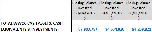
Monthly and Annual Performance
Interest/growth/capital gains for the month totaled $195,228 which compares unfavourably with the budget for the period of $253,554 – under performing budget for the June month by $58,326. This is attributable to the negative growth experienced for Council’s NSW T-Corp managed funds of $23,124 as well as some discounting of Council’s Floating Rate Note portfolio. June’s result, combined with the previous 11 months performance has resulted in a positive result for Council’s portfolio, outperforming budget for the full 2015/16 financial year by $54,048.
It should be noted that the capital market value of Council’s Floating Rate Note investments will fluctuate from month to month and that Council continues to receive the coupon payments and the face value of the investment security when sold or at maturity.
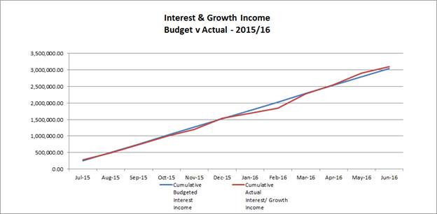
Certificate: I hereby certify that all of the above investments have been made in accordance with the provision of Section 625 of the Local Government Act 1993 and the regulations there under, and in accordance with the WWCC Investments Policy adopted by Council on 26 August 2013.
C Rodney
Responsible Accounting Officer
Budget
The forecast full year budget result to 30 June 2016 is a balanced budget.
Policy
Investments are reported in accordance with POL 075 Investment Policy.
Budget Variations are reported in accordance with POL 052 Budget Policy.
Impact on Public Utilities
N/A
Link to Strategic Plan
1. We are an engaged and involved community
1.1 We are a community that is informed and involved in decisions impacting us
QBL Analysis
|
|
Positive |
Negative |
|
Social |
N/A |
N/A |
|
Environmental |
N/A |
N/A |
|
Economic |
N/A |
N/A |
|
Governance |
The preparation of the monthly financial report provides for the timely reporting on investments. Approval of the carryover requests will allow the completion of the projects as adopted in the 2015/16 budget. |
N/A |
Risk Management and Work Health and Safety Issues for Council
No specific issues identified.
Internal / External Consultation
All relevant areas within Council have consulted with the Finance Division in regards to the carry over projects listed in this report.
The Finance Division has consulted with relevant external parties to confirm Council’s investment portfolio balances.
|
1⇩. |
Carryover list + Works in Progress Report - 2015.16 |
|
|
2⇩. |
Investment Summary as at 30 June 2016 |
|
Report submitted to the Ordinary Meeting of Council on Monday 25 July 2016. RP-7
![]()

Report submitted to the Ordinary Meeting of Council on Monday 25 July 2016. RP-7
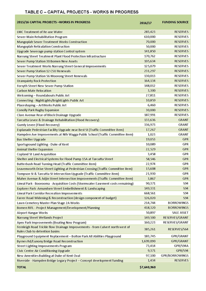
Report submitted to the Ordinary Meeting of Council on Monday 25 July 2016. RP-7
![]()

RP-8 AUSTRALIAN CLAY TARGET ASSOCIATION PROPOSED ACQUISITION OF LAND
Author: Gardiner, Mark
Director: Summerhayes, Janice
|
That Council: a receive and note the report b defer consideration of selling the parcel of land Lot 102 DP1012965 to the Australian Clay Target Association until the completion of the Wagga Wagga Revised Floodplain Risk Management Study |
Report
The Australian Clay Target Association (ACTA) has requested Council consider selling the parcel of land Lot 102 DP1012965 adjoining the National Clay Target Ground in Tasman Road for a nominal amount. ACTA currently has a licence over the land which expires on 31 July 2016.
The ACTA is planning for the future development of the sport and in particular the World Down The Line (DTL) Championships in 2018. The acquisition of this land would enable ACTA to further develop the land including construction of a National building on the Tasman Road site to house the National ACTA office, clubhouse, National Hall of fame and events office to align with their strategic goals. Funding for the project would include the sale of the existing National ACTA office site in Copland Street (Lot 100 DP 1012965).
The parcel of land is approximately 2.6 hectares in size and was retained by Council for a potential eastern industrial levee in the future. The potential for providing flood protection to the industrial area in east Wagga Wagga included a concept for an eastern industrial levee surrounding the areas near Tasman Road, Hammond Ave and Kooringal Road.
The Wagga Wagga Floodplain Risk Management Study 2009, developed by WMA Water concluded:
“Due to the significant flood risk at Gumly Gumly (and in other areas) associated with the protection of east Wagga, as well as the impacts on flood evacuation for the area, any protection by a levee is considered to be unacceptable. There are no real compensatory measures that will adequately reduce the hydraulic impacts at Gumly Gumly.
Council’s current filling policy will produce a similar beneficial outcome for landholders within the eastern area while limiting impact upstream at Gumly Gumly and still allowing for broad scale economic benefits through the protection of the eastern industrial area. The construction of a levee would remove additional floodplain storage width which would not be lost under Council’s current policy, hence reducing the flood level impact at Gumly Gumly.”
Infrastructure Services have recommended any decision related to the sale of this portion of land should be deferred until the completion of the Wagga Wagga Revised Floodplain Risk Management Study and Plan. It is anticipated the draft study will be completed by the end of this year before being placed on public exhibition.
Budget
N/A
Policy
N/A
Impact on Public Utilities
N/A
Link to Strategic Plan
1. We are an engaged and involved community
1.1 We are a community that is informed and involved in decisions impacting us
QBL Analysis
|
|
Positive |
Negative |
|
Social |
Meeting community wellbeing outcomes as per Council’s strategic plans, particularly the Recreation and Open Space, Social and Cultural Plans. |
N/A |
|
Environmental |
N/A |
N/A |
|
Economic |
Meeting community outcomes as per Council’s strategic plans and fostering local economic activity. |
N/A |
|
Governance |
N/A |
N/A |
Risk Management and Work Health and Safety Issues for Council
Any risk management and work health and safety matters will be addressed as part of the day to day operations.
Internal / External Consultation
Consultation has been undertaken within Council and with Australian Clay Target Association.
|
1⇩. |
Letter Australian Clay Target Association |
|
|
2⇩. |
Location Map Lot 102 DP1012965 |
|
Report submitted to the Confidential Meeting of Council on Monday 25 July 2016. CONF-1
CONF-1 PROPOSED LEASE RENEWAL - BOTANIC GARDENS RESTAURANT SITE
Author: Wright, Dianne
Acting Director: Bolton, James
This report is CONFIDENTIAL in accordance with Section 10A(2) of the Local Government Act 1993, which permits the meeting to be closed to the public for business relating to the following: -
(c) information that would, if disclosed, confer a commercial advantage on a person with whom the Council is conducting (or proposes to conduct) business.
Report submitted to the Confidential Meeting of Council on Monday 25 July 2016. CONF-2
CONF-2 PROPOSED VARIATION - AIRPORT SUB-LEASE TO MAGUIRE
Author: Wright, Dianne
Acting Director: Bolton, James
This report is CONFIDENTIAL in accordance with Section 10A(2) of the Local Government Act 1993, which permits the meeting to be closed to the public for business relating to the following: -
(d) (ii) commercial information of a confidential nature that would, if disclosed, confer a commercial advantage on a competitor of the Council.
Report submitted to the Confidential Meeting of Council on Monday 25 July 2016. CONF-3
CONF-3 COUNCIL ORGANISATION STRUCTURE REVIEW
General Manager: Eldridge, Alan
This report is CONFIDENTIAL in accordance with Section 10A(2) of the Local Government Act 1993, which permits the meeting to be closed to the public for business relating to the following: -
(a) personnel matters concerning particular individuals.
Report submitted to the Confidential Meeting of Council on Monday 25 July 2016.
QUESTIONS/BUSINESS WITH NOTICE
Report submitted to the Confidential Meeting of Council on Monday 25 July 2016.
Minutes of the Supplementary Meeting of Council held on Monday 11 July 2016.
Present
The Mayor, Councillor Rod Kendall
Councillor Yvonne Braid
Councillor Alan Brown
Councillor Greg Conkey OAM
Councillor Paul Funnell
Councillor Garry Hiscock
Councillor Julian McLaren
Councillor Kerry Pascoe
Councillor Kevin Poynter
Councillor Dallas Tout
In Attendance
General Manager (Mr A Eldridge)
Acting Director Commercial & Economic Development (Mr J Bolton)
Director Corporate Services (Mr C Richardson)
Director Environmental & Community Services (Mrs J Summerhayes)
Manager Corporate Strategy, Communications &
Governance (Mrs C Priest)
Manager Finance (Mrs C Rodney)
Manager Engineering (Mr A Fenwick)
Project Manager – Assets (Mr N Nixon)
Communications & Engagement Officer (Mr J Lang)
Corporate Governance & Risk Coordinator (Mrs J Watkins)
The Supplementary Council meeting commenced at 9:14pm.
Prayer
Almighty God,
Help protect our Mayor, elected Councillors and staff.
Help Councillors to govern with justice, integrity, and respect for equality, to preserve rights and liberties, to be guided by wisdom when making decisions and settling priorities, and not least of all to preserve harmony.
Amen.
Acknowledgement Of Country
I would like to acknowledge the Wiradjuri people who are the Traditional Custodians of this Land. I would also like to pay respect to the Elders both past and present of the Wiradjuri Nation and extend that respect to other Community members present.
APOLOGIES
No apologies were received.
CONFIRMATION OF MINUTES
|
CM-1 ORDINARY COUNCIL MEETING - 27 JUNE 2016 |
|
|
|
16/172 RESOLVED: On the Motion of Councillors A Brown and K Poynter That the Minutes of the proceedings of the Ordinary Council Meeting held on 27 June 2016 be confirmed as a true and accurate record. CARRIED |
Declarations Of Interest
Councillor A Brown declared a Pecuniary Interest, the reason being that he provides professional training services to Council.
closed COUNCIL
|
16/173 RESOLVED: On the Motion of Councillors P Funnell and A Brown That the Council now resolve itself into a Closed Council, the time being 9:16pm. CARRIED |
AT THIS STAGE OF THE MEETING THE PRESS AND PUBLIC GALLERY RETIRED FROM THE COUNCIL MEETING.
At this stage of the meeting, Project Director, Parsons Brinckerhoff, Mr Mark Nugter, was invited into the meeting, the time being, 9:16pm.
CONF-1 RFT 2016/015 SEWER REHABILITATION KOORINGAL & ASHMONT |
|
|
|
16/174 RESOLVED: On the Motion of Councillors G Conkey OAM and A Brown That Council: a accept the tender of Keough’s Plant Hire Pty Ltd for the Rehabilitation of Gravity Sewer Mains in Kooringal and Ashmont in the lump sum amount of $1,048,725 including GST b authorise the General Manager or his delegate to enter into a contract with Keough’s Plant Hire Pty Ltd for the Rehabilitation of Gravity Sewer Mains in Kooringal and Ashmont c authorise the affixing of Council’s Common Seal to all relevant documents as required CARRIED |
|
CONF-2 BOMEN ENABLING ROADS AND RFT 2016/013 |
|
|
|
16/175 RESOLVED: On the Motion of Councillors G Conkey OAM and P Funnell That Council: a note the report from the tender evaluation panel (Attachment 1 - RFT 2016/013 Evaluation report) in relation to the tenders submitted in response to Design & Construct Bomen Link Roads and Underpass - Bomen Request for Tender Number 2016/013 (RFT) b in accordance with clause 178(1)(b) of the Local Government (General) Regulation 2005 (LG Regulation), decline to accept any of the tenders submitted in response to the RFT c in accordance with 178(3)(e) of the LG Regulation, authorise the General Manager to: i enter into direct negotiations with the tenderer identified for direct negotiations in the report from the tender evaluation panel (Attachment 1 - RFT 2016/013 Evaluation report), with a view to entering into a contract in relation to the subject matter of the RFT ii execute any contract arising from those direct negotiations, provided that the terms of the contract fall within the parameters specified in the report from the tender evaluation panel (Attachment 1 - RFT 2016/013 Evaluation report) d note that the reason for declining to invite fresh tenders or applications is that it is not expected that further market testing will provide a more satisfactory result e note that the reason for determining to enter into negotiations with the specified tenderer is: i the tender submitted by that tenderer achieved the highest score by the tender evaluation panel; and ii Council considers that through negotiations the final terms of the contract will be able to be successfully settled with that tenderer f advise the unsuccessful tenderers in writing g note and approve the budget variation/s as detailed in the budget section of the report h pursues the funding options 1,3 and 4 contained in the body of the report for recouping a portion of its contribution towards the capital cost of the Bomen enabling roads CARRIED |
Reversion to open COUNCIL
|
16/176 RESOLVED: On the Motion of Councillors A Brown and K Poynter That this meeting of the Closed Council revert to an open meeting of the Council, the time being 9:17pm. CARRIED |
report of proceedings of closed COUNCIL
|
16/177 RESOLVED: On the Motion of Councillors K Pascoe and A Brown That the recommendations contained in the report of the proceedings of the Closed Council be adopted. CARRIED |
Councillors requested that a unanimous vote be recorded for CONF-2 BOMEN ENABLING ROADS AND RFT 2016/013.
QUESTIONS/BUSINESS WITH NOTICE
No Questions/Business with Notice received.
THIS COMPLETED THE BUSINESS OF THE SUPPLEMENTARY COUNCIL MEETING WHICH ROSE AT 9:19pm.
…………………………………………………..
MAYOR