 Traffic Committee
To be held on
Thursday,
13 July 2017
AT 9.15am
Cnr Baylis and Morrow Streets,
Wagga Wagga NSW 2650
PO Box 20, Wagga Wagga
Phone: 1300 292 442
Fax: 02 6926 9199
Website: www.wagga.nsw.gov.au
Traffic Committee
To be held on
Thursday,
13 July 2017
AT 9.15am
Cnr Baylis and Morrow Streets,
Wagga Wagga NSW 2650
PO Box 20, Wagga Wagga
Phone: 1300 292 442
Fax: 02 6926 9199
Website: www.wagga.nsw.gov.au
Reports submitted to the Traffic Committee to be held on Thursday 13 July 2017.
Traffic Committee AGENDA AND BUSINESS PAPER
Thursday 13 July 2017
ORDER OF BUSINESS:
CLAUSE PRECIS PAGE
ACKNOWLEDGEMENT OF COUNTRY 2
APOLOGIES 2
Confirmation of Minutes
CM-1 Traffic Committee Meeting - 11 May 2017 2
DECLARATIONS OF INTEREST 2
Reports
RP-1 WAGGA WAGGA CLASSIC CRITERIUM - ON-STREET EVENT 3
RP-2 NEW SOUTH WALES JUNIOR ROAD RACE CYCLING CHAMPIONSHIPS - CRITERIUM - ON-STREET EVENT 3
RP-3 WAGGA WAGGA CYCLING CLUB - WEEKLY RACES - ON-STREET EVENT 3
RP-4 TOLLAND CYCLING CLUB - WEEKLY RACES - ON-STREET EVENT 3
RP-5 WAGGA WAGGA TO ALBURY WOODMAN CLASSIC CYCLE RACE - ON-STREET EVENT 3
RP-6 WAGGA WAGGA TRAIL MARATHON AND MOUNTAIN BIKE RACE - ON-STREET EVENT 3
RP-7 TOWN AND GOWN PARADE - ON-STREET EVENT 3
RP-8 RIVERINA DAY SURGERY - COMMUNITY FACILITY DIRECTION SIGNS 3
RP-9 BEST STREET - MARK PARALLEL PARKING BAYS 3
RP-10 PLUMPTON ROAD AND SPRINGVALE DRIVE - TREATMENT OPTIONS TO ASSIST TURN MOVEMENTS 3
RP-11 PLUMPTON ROAD - DOUBLE UNBROKEN SEPARATION LINES 3
RP-12 KIMBA DRIVE - STOP SIGN AT INTERSECTION WITH DALMAN PARKWAY 3
RP-13 FRANKLIN DRIVE - STOP SIGN CONTROL AT THE INTERSECTION WITH SAMPSON AVENUE 3
RP-14 AVOCET DRIVE PEDESTRIAN REFUGE - DA14-0673 3
RP-15 LEWIS DRIVE - CHANGE TO TRAFFIC FLOW AND YABTREE STREET - STOP SIGN AT INTERSECTION WITH LEWIS DRIVE 3
RP-16 DORIS ROY LANE - CHANGES TO PARKING CONTROLS 3
RP-17 MORGAN STREET - TIMED PARKING NEAR BEST STREET 3
QUESTIONS WITH NOTICE
ACKNOWLEDGEMENT OF COUNTRY
APOLOGIES
Confirmation of Minutes
CM-1 Traffic Committee Meeting - 11 May 2017
|
That the Minutes of the proceedings of the Traffic Committee Meeting held on 11 May 2017 be confirmed as a true and accurate record.
|
|
1⇩. |
Minutes - 11 May 2017 |
3 |
DECLARATIONS OF INTEREST
Report submitted to the Traffic Committee on Thursday 13 July 2017. RP-1
RP-1 WAGGA WAGGA CLASSIC CRITERIUM - ON-STREET EVENT
Author: Bill Harvey
|
Traffic Committee note that the following matter was distributed to members by email on 2 May 2017 with members responding in favour of the conduct of the event. That Traffic Committee endorse the conduct of the Wagga Classic Criterium event on Sunday 2 July 2017 which will involve road closures in the central business district, allowing the event to run on Ivan Jack Drive to Best Street, Best Street to Tompson Street, Tompson Street to Peter Street, Peter Street to Morrow Street, Morrow Street to Baylis Street, Baylis Street to Fitzmaurice Street, Fitzmaurice Street to Johnston Street and Johnston Street to Ivan Jack Drive subject to the conditions that appear below: a The arrangements regarding route, timing and other issues that are set out in the application documents are adhered to. b All provisions of Road Transport Legislation to be complied with. c Approval pursuant to section 115 of the Road Transport Act, 2013 being given by the Commissioner of Police or his delegated officer. d Any direction given by a member of the NSW Police that is pursuant to Road Transport Legislation or Occupational Health and Safety Legislation is to be promptly complied with. e Any direction that is given by an Officer of Wagga Wagga City Council is to be promptly complied with. f Failure to comply with any of these conditions will immediately void approval for the event. g Authorised Traffic Control Plans are to be implemented, monitored and removed by a person who holds the appropriate level of ‘Traffic Control at Worksites’ accreditation. All provisions of the Guide to Traffic Control at Worksites manual version 4 must be complied with. h Responsibility for sourcing signs, barriers and traffic cones, required for implementation of the traffic control plans, lays with the Wagga Wagga Cycling Club. i Wagga Wagga Cycling Club are to notify the local bus service provider and taxi service provider by the 10 June 2017 and inform those organisations of the extent of the road closures and the detour routes that will be in place. j Wagga Wagga Cycling Club are to notify NSW Fire & Rescue and the NSW Ambulance Service of the traffic control arrangements for the event and make provisions for emergency access to the closed area, if necessary. k All races being run in accordance with NSW Bicycle Federation rules. l Notification of the event provisions is to be conveyed personally not later than 25 June 2017 to every resident within the area that is affected by the criterium event on 2 July 2017 and suitable, reasonable arrangements made with each resident to meet their individual needs for access to and from their properties. m In the event of any dispute between a resident and the event organiser in respect of the provisions of point ‘l’ (above), the matter is to be referred at the earliest opportunity to the City of Wagga Wagga Traffic Section for adjudication. n An adequate number of event marshals is to be provided to each location around the criterium course where traffic control devices are implemented to maintain the devices and to encourage safe spectator behaviour. |
Report
Application has been received from the Wagga Wagga Cycling Club to conduct a cycling event in Wagga Wagga on the Sunday 2 July 2017. This is a continuation of the event that commenced in 2008. The road race portion of the event has been dealt with separately.
This event involves a series of criterium races on a closed course in the Wagga Wagga CBD. See attached map. This event will start at 8:30am and conclude by 2:00pm. Due to the quantity of traffic control initiatives that are required, setup for the event will commence from 6:30am.
Wagga Wagga Cycling Club has undertaken the responsibility to personally visit every resident that will be affected by the conduct of this event and to take action to satisfy all reasonable requests from those residents to meet needs for access to and from the residents’ properties.
Appropriate certified traffic control plans to manage this event have been supplied. The same arrangements have been employed over a number of years with no adverse issues relating to the safety of either participants or the non-event community have occurred.
Cost
Estimated cost of implementing this initiative $Nil - All costs are met by the event organiser.
Risk Management Issues for Council
The purpose of this report is to adequately manage risks that are associated with an on-street event on behalf of Council.
The risk involved in this matter without any treatment has been assessed as – Likely / Major which places it in the – High category.
Internal / External Consultation
Consultation was undertaken with the event organiser.
Report submitted to the Traffic Committee on Thursday 13 July 2017. RP-2
RP-2 NEW SOUTH WALES JUNIOR ROAD RACE CYCLING CHAMPIONSHIPS - CRITERIUM - ON-STREET EVENT
Author: Bill Harvey
|
That Traffic Committee members note that the following matter was delivered to members electronically on 4 May 2017 with members responding unanimously in favour of the conduct of the event. That Traffic Committee endorse the conduct by the Wagga Wagga Cycling Club of the New South Wales Junior Road Racing Championships on Sunday 13 August 2017 which will involve road closures in the central business district, allowing the event to run on Ivan Jack Drive to Best Street, Best Street to Tompson Street, Tompson Street to Peter Street, Peter Street to Morrow Street, Morrow Street to Baylis Street, Baylis Street to Fitzmaurice Street, Fitzmaurice Street to Johnston Street and Johnston Street to Ivan Jack Drive subject to the conditions that appear below: a The arrangements regarding route, timing and other issues that are set out in the application documents are adhered to. b All provisions of Road Transport Legislation to be complied with. c Approval pursuant to section 115 of the Road Transport Act, 2013 being given by the Commissioner of Police or his delegated officer. d Any direction given by a member of the NSW Police that is pursuant to Road Transport Legislation or Occupational Health and Safety Legislation is to be promptly complied with. e Any direction that is given by an Officer of Wagga Wagga City Council is to be promptly complied with. f Failure to comply with any of these conditions will immediately void approval for the event. g Authorised Traffic Control Plans are to be implemented, monitored and removed by a person who holds the appropriate level of ‘Traffic Control at Worksites’ accreditation. All provisions of the Guide to Traffic Control at Worksites manual version 4 must be complied with. h Responsibility for sourcing signs, barriers and traffic cones, required for implementation of the traffic control plans, lays with the Wagga Wagga Cycling Club. i Wagga Wagga Cycling Club are to notify the local bus service provider and taxi service provider by the 10 June 2017 and inform those organisations of the extent of the road closures and the detour routes that will be in place. j Wagga Wagga Cycling Club are to notify NSW Fire & Rescue and the NSW Ambulance Service of the traffic control arrangements for the event and make provisions for emergency access to the closed area, if necessary. k All races being run in accordance with NSW Bicycle Federation rules. l Notification of the event provisions is to be conveyed personally not later than 5 August 2017 to every resident within the area that is affected by the criterium event on 13 August 2017 and suitable, reasonable arrangements made with each resident to meet their individual needs for access to and from their properties. m In the event of any dispute between a resident and the event organiser in respect of the provisions of point ‘l’ (above), the matter is to be referred at the earliest opportunity to the City of Wagga Wagga Traffic Section for adjudication. n An adequate number of event marshals are to be provided to each location around the criterium course where traffic control devices are implemented to maintain the devices and to encourage safe spectator behaviour. o event on 2 July 2017 and suitable, reasonable arrangements made with each resident to meet their individual needs for access to and from their properties. p In the event of any dispute between a resident and the event organiser in respect of the provisions of point ‘l’ (above), the matter is to be referred at the earliest opportunity to the City of Wagga Wagga Traffic Section for adjudication. q An adequate number of event marshals is to be provided to each location around the criterium course where traffic control devices are implemented to maintain the devices and to encourage safe spectator behaviour. |
Report
Application has been received from the Wagga Wagga Cycling Club on behalf of NSW Cycling to conduct the NSW Cycling Junior Road Championship Criterium event in Wagga Wagga on Sunday 13 August 2017. This event will use the same course and setup as the Wagga Classic cycling event criterium.
The whole championship is held over two days being Saturday 12 and Sunday 13 August 2016. The road race is held on a course that is outside of Wagga Wagga LGA, starting and finishing in Wantabadgery.
The second day of the event, Sunday 13 August, involves a series of criterium races on a closed course in the Wagga Wagga CBD. See attached map. This event will start at 8:30am and conclude by 2pm. Due to the quantity of traffic control initiatives that are required, setup for the event will commence from first daylight. Pack up with all roads open is expected to be complete by 2pm.
Similar arrangements will be implemented for this event as have been used for other criterium events on the same course over the past several years.
Appropriate traffic control plans to manage the criterium event are attached. Traffic control plans will be implemented and monitored by a private traffic control contractor for this event.
Risk Management Issues for Council
The purpose of this report is to adequately manage risks that are associated with an on-street event on behalf of Council.
The risk involved in this matter without any treatment has been assessed as – Likely / Major which places it in the – High category.
Internal / External Consultation
Consultation was undertaken with the event organiser.
Report submitted to the Traffic Committee on Thursday 13 July 2017. RP-3
RP-3 WAGGA WAGGA CYCLING CLUB - WEEKLY RACES - ON-STREET EVENT
Author: Bill Harvey
|
That Traffic Committee note that the following matter was distributed to members by email on 28 March 2017 with members responding unanimously in favour of the event.
That Traffic Committee endorses the conduct of a weekly bicycle race club meeting on a course at Big Springs at per attached maps, subject to the following conditions: a The arrangements regarding route, timing and other issues that are set out in the application documents are adhered to, b All provisions of Road Transport Legislation are complied with, c Approval pursuant to section 115 of the Road Transport Act, 2013 being given by the Commissioner of Police or his delegated officer. d Any direction given by a member of the NSW Police that is pursuant to Road Transport Legislation or Occupational Health and Safety Legislation is to be promptly complied with, e Any reasonable direction that is given by an Officer of Wagga Wagga City Council is to be promptly complied with, f Authorised Traffic Control Plans to be implemented, monitored and removed by a person who holds the appropriate level of "Traffic Control at Worksites" certification, g Racing should not commence or should immediately cease in the event that sight distance, due to weather or other conditions, does not render an adult person wearing dark clothing clearly visible at a distance of 200 metres. h Responsibility for sourcing signs, barriers and witches hats, required for implementation of the traffic control plans, lays with Wagga Wagga Cycling Club, i Production of a copy of the renewed public liability insurance certificate of currency to Wagga Wagga City Council after the current policy expires on 30 November 2017, before any further racing is undertaken, j The race is to be run in accordance with NSW Bicycle Federation rules, k Failure to comply with any of these conditions will immediately void approval for the event. |
Report
Wagga Wagga Cycling Club have applied for permission to conduct a weekly race meeting, commencing either at 9:30am and finishing no later than 12:30pm on Sundays, commencing from 1 April 2017 and running until 31 December 2017.
The race normally involves 20 to 50 competitors each weekend. Groups of riders will be started at varying times. The club has indicated that groups will not exceed eight riders. Start times for groups will be spaced so that they do not overlap while on the course.
The nominated course on Big Springs Road and Compton Road has been used for this purpose for some time without incident involving other road users. Traffic is extremely light at this time of the week. The course is suitable for both junior and senior riders. The start/finish location and turn-around points have good visibility in all directions.
Risk Management Issues for Council
The purpose of this report is to adequately manage risks that are associated with an on-street event on behalf of Council.
The risk involved in this matter without any treatment has been assessed as – Likely / Major which places it in the – High category.
Internal / External Consultation
Consultation was undertaken with the event organiser.
Report submitted to the Traffic Committee on Thursday 13 July 2017. RP-4
RP-4 TOLLAND CYCLING CLUB - WEEKLY RACES - ON-STREET EVENT
Author: Bill Harvey
|
That Traffic Committee note that the following matter was distributed to members by email on 21 June 2017 with members responding in favour of the event. That Traffic Committee endorses the conduct of a weekly bicycle race club meeting on a course along Uranquinty Cross Road between Uranquinty and The Rock-Collingullie Road, subject to the following conditions: a The arrangements regarding route, timing and other issues that are set out in the application documents are adhered to, b All provisions of Road Transport Legislation are complied with. c Approval pursuant to section 115 of the Road Transport Act, 2013 being given by the Commissioner of Police or his delegated officer. d Any direction given by a member of the NSW Police that is pursuant to Road Transport Legislation or Work Health and Safety Legislation is to be promptly complied with. e Any reasonable direction that is given by an Officer of Wagga Wagga City Council is to be promptly complied with. f Authorised Traffic Control Plans to be implemented, monitored and removed by a person who holds the appropriate level of "Traffic Control at Worksites" certification. g Racing should not commence of should immediately cease in the event that sight distance, due to weather or other conditions, does not render an adult person wearing dark clothing clearly visible at a distance of 200 metres. h Responsibility for sourcing signs, barriers and witches hats, required for implementation of the traffic control plans, lays with Tolland Cycling Club, i Production of a copy of the renewed public liability insurance certificate of currency to Wagga Wagga City Council after the current policy expires on 30 November 2016, before any further racing is undertaken, j The race is to be run in accordance with NSW Bicycle Federation rules, k Failure to comply with any of these conditions will immediately void approval for the event. |
Report
Tolland Cycling Club has applied for permission to conduct a weekly race meeting, commencing either at 9am and finishing about 11am on Sundays, commencing from the first available date and running until the end of the 2017 – 2018 racing season (30 June 2018).
The race involves about four to six groups of competitors with five or six riders in each group on each weekend. Groups of riders will be started at varying times. Start times for groups will be spaced so that they should not overlap while on the course.
The event course that is proposed for this year has not previously been used for this purpose. Other courses are unsuitable at the present time due to the poor condition of the road seal. Uranquinty Cross Road is in good condition. The road and the environment is suitable for club level road racing events.
The event will start and finish outside of the Uranquinty urban area, about 500 metres west of Baker Street. The turnaround point will be about 600 metres east of the intersection with The Rock – Collingullie Road. Sight distance for approaching traffic at both locations is excellent.
The speed limit on this section of Uranquinty Cross Road is default rural – 100 km/h. Traffic volumes are very low, particularly on Sunday morning, estimated to be less than 5 vehicles per hour.
Risk Management Issues for Council
The purpose of this report is to adequately manage risks that are associated with an on-street event on behalf of Council.
The risk involved in this matter without any treatment has been assessed as – Likely / Major which places it in the – High category.
Internal / External Consultation
Consultation was undertaken with the event organiser.
Report submitted to the Traffic Committee on Thursday 13 July 2017. RP-5
RP-5 WAGGA WAGGA TO ALBURY WOODMAN CLASSIC CYCLE RACE - ON-STREET EVENT
Author: Bill Harvey
|
That Traffic Committee note that the following matter was distributed to members by email on 26 May 2017 with members responding in favour of the recommendation.
That Traffic Committee endorse the running of the Wagga Wagga to Albury Woodman Cycle Classic on Sunday 30 July 2017, starting in Holbrook Road, near the intersection with Deakin Avenue, subject to the following conditions:
a The arrangements regarding route, timing and other issues that are set out in the application documents are adhered to. b Approval granted by the NSW Police under Section 115 of Road Transport Act 2013 c All provisions of Road Transport Legislation are complied with. d Any reasonable direction given by a member of the New South Wales Police Force is to be promptly complied with. e Any reasonable direction that is given by an Officer of Wagga Wagga City Council is to be promptly complied with. f Authorised Traffic Control Plans to be implemented, monitored and removed by a person who holds the appropriate level of ‘Traffic Control at Worksites’ certification. g Responsibility for supplying signs and authorised traffic controllers lays with the event organiser, with no obligation on Wagga Wagga City Council to assist with any form of traffic management for this event. h The event being run in accordance with NSW Bicycle Federation rules. i Consent for this event being given by Greater Hume and Albury Councils j Failure to comply with any and all of the above conditions will immediately void this approval. |
Report
An application has been received from the Albury Wodonga Panthers Cycling Club to conduct the Wagga Wagga to Albury John Woodman Cycle Classic on Sunday 30 July 2017. The event is planned to start in Holbrook Road, Lloyd and continue south on that road to the LGA boundary with Greater Hume Shire, south of Mangoplah. Event participants will be started in four groups from 10am with a time gap between groups of approximately 10 minutes. The TCP road closures will be implemented from 9:30am. It is anticipated that the road will be open to traffic by 10:45am.
This is an annual event that has been conducted over a period of 31 years. The event has been subject to the normal range of racing ‘events’ over it’s life. At no time has there been a suggestion that the event organisation was lacking or that the organisation contributed to any adverse event in Wagga Wagga LGA.
A representative from the Club has been in contact with Wagga Wagga City Council regarding the Traffic Control plans for the start of the event. The reviewing officer at the City of Wagga Wagga is satisfied with the content of the Traffic Control Plans for locations in the Wagga Wagga Local Government Area.
The relevant papers for this application are attached and include a Traffic Management Plan and a Traffic Control Plan that demonstrates a graphical depiction as per the ‘Traffic Control at Worksites Manual’.
Risk Management Issues for Council
The purpose of this report is to adequately manage risks that are associated with an on-street event on behalf of Council.
The risk involved in this matter without any treatment has been assessed as – Likely / Major which places it in the – High category.
Internal / External Consultation
Consultation was undertaken with the event organiser.
Report submitted to the Traffic Committee on Thursday 13 July 2017. RP-6
RP-6 WAGGA WAGGA TRAIL MARATHON AND MOUNTAIN BIKE RACE - ON-STREET EVENT
Author: Bill Harvey
|
That Traffic Committee members note that the following matter was delivered to members electronically on 22 June 2017 with members responding in favour of the conduct of the event. That Traffic Committee endorse the conduct of the Wagga Wagga Trail Marathon and Mountain Bike Race on Sunday 20 August 2017 which will involve temporary road closures on Moorong Street, Holbrook Road, Kimberley Drive, Plumpton Road, Lakeside Drive, Lake Albert Road, Kooringal Road and Copland Street and lesser degrees of traffic control on Flowerdale Road, Edward Street West, McNickle Road and Kooringal Road to facilitate the conduct of the event to the conditions that appear below. a The arrangements regarding route, timing and other issues that are set out in the application documents are adhered to. b All provisions of Road Transport Legislation to be complied with. c Any reasonable direction given by a member of the NSW Police is to be promptly complied with. d Any reasonable direction that is given by an Officer of Wagga Wagga City Council is to be promptly complied with. e Failure to comply with any of these conditions will immediately void approval for the event. f Authorised Traffic Control Plans to be implemented, monitored and removed by person/s that hold the appropriate level of "Traffic Control at Worksites" certification. g The effect on the non-event community by road closures is to be minimised as far as possible by keeping the length of time that traffic is actually stopped to an absolute minimum. h All participants are to comply with the relevant provisions of Road Transport Legislation with particular emphasis to the controls and constraints that are placed upon pedestrians by the Road Rules, 2008. i Responsibility for sourcing signs, barriers and witches hats, required for implementation of the traffic control plans, lies with the Event Organising Committee. j Responsibility for the installation and removal of traffic control plans also lies with the event organiser. k The Mountain Bike race that forms part of this overall event shall not run unless permission is first granted by the Commissioner of Police, or his delegated Officer, under the provisions of Section 115 of the Road Transport Act 2013. l The Mountain Bike race that forms part of this overall event shall be conducted under the racing rules that are made and administrated by Mountain Bike Australia, as the governing body for that sport. m The organiser must produce a copy of a certificate of currency for a public liability insurance policy, to the minimum value of $20 million, endorsing Wagga Wagga City Council and the NSW Roads and Maritime Services as interested parties in this event, to Wagga Wagga City Council not later than close of business on 11 August 201t. n The Event Organising Committee will notify NSW Fire Brigade and Ambulance Service of the traffic control arrangements for the event and make provisions for emergency access in the area, if necessary. o Notification of the situation and liaison with residents that are directly affected by the route and suitable, reasonable arrangements made with those residents to meet their individual needs for access to and from their properties. p An adequate number of marshals, as per the authorised traffic control plans as a minimum, to be provided to each location around the course where traffic control devices are implemented to maintain the devices and to encourage safe spectator behaviour. q All ‘Stop/Slow’ controllers to be appropriately qualified by the Roads and Traffic Authority to perform such tasks, i.e. holder of current ‘Blue’ card. r In the event that a person wearing dark coloured clothing is not clearly visible at a distance of 100 metres all activity that is associated with this event on the various road reserves is to immediately cease. |
Report
Application has been received from the Wagga Wagga Road Runners, Inc, to conduct a Trail Marathon foot race in Wagga Wagga on Sunday 20 August, 2017. This is the tenth year that the event has been proposed. The same course is to be used as for previous years. All previous events have been conducted without incident.
A substantial addition to the event has been added from the 2014 event. A mountain bike race event has been held on the course, under the Mountain Bike Australia rules for such events. That race commenced 15 minutes before the main marathon event. The commencement time for the mountain bikes is 8:15am which is 1hr 15mins after the ‘Early Starter’ event commenced. The event was run without adverse incident and it was agreed that it should be repeated in future years.
Mountain bike riders catch and pass the early starter runners on the section of the course that is near Lake Albert. That is a suitable area to allow for easy and safe passing of the runners by the mountain bike competitors.
The combined event application papers are attached.
Times
The events are timed to start from 7:00am and will be completed with traffic controls de-commissioned before 4:00pm.
Course
The Start/Finish will be at the Wagga Wagga Beach adjacent to the Bidgee Canoe Club rooms on the walking path. There is ample parking for competitors, officials and supporters at the beach area.
· From the start the course follows the walking path along the river levee bank toward the south, passing under Hammond Ave (Sturt Hwy) at Marshals Creek.
· The course continues on the shared path beside Kooringal Rd, crossing Copland St near the roundabout. That portion of Copland St is closed to traffic during the event.
· The course continues along the shared path on the western side of Kooringal Rd. The course crosses Kooringal Rd at the old railway crossing. That crossing point will be managed by traffic controllers. The course continues south along the eastern side of Kooringal Rd, crossing Vincent Rd with the aid of a race marshal to manage competitors.
· The course continues on the eastern/southern side of Kooringal Rd, turning left on the shared path at Lake Albert Rd. The course crosses Lake Albert Rd near Lakeside Dr.
· The course crosses Lakeside Dr and enters a reserve area that is free of traffic.
· The course follows shared paths to Plumpton Rd which is crossed south of Kooringal / Red Hill Rd. The course follows the western side of Plumpton Rd to Red Hill Rd where it turns left and follows a path along the southern side of Red Hill Rd.
· The course crosses Kimberley Dr, which will be closed to traffic. The course continues to and then crosses Tamar Dr near the intersection with Red Hill Rd. This arrangement has been used for the past two years with event marshals controlling runners at this crossing.
· The course follows the southern side of Red Hill Rd to the top of Willans Hill where it leaves the road and follows the Wiradjuri Walking Track south, along the ridge line to Clifton St which will be crossed near the Kaloona Dr roundabout.
· The course turns right onto the eastern side of Holbrook Rd before crossing to the western side of Holbrook Rd north of Clifton St. The course follows the western side of the road reserve which is substantially separated from the road by grade, distance and vegetation.
· The course leaves the road reserve at Ross Smith Dr, a Crown Road that is used infrequently by vehicular traffic. The course follows the Wiradjuri Walking Track, which has been rerouted along a ridge line that is well off the road network, to a crossing point on the Sturt Hwy near McNickle Rd. Provided that there is no flooding in the creek, the course will pass under the Sturt Hwy using a culvert that has been developed to accommodate pedestrian traffic. In the event of flooding in the culvert the event will cross over the Sturt Hwy at the same location which will be controlled by an authorised TCP, and operated by two traffic controllers and with a speed restriction in place.
· The course follows a path beside the access road to the Wagga City Golf Course and then entering the Pomigalana Reserve, which will be closed to vehicular traffic. The course returns to the road network at McNickle Rd where it follows the western side of that road to Edward St West. It follows the northern side of that road before again following the Wiradjuri Walking Track to Flowerdale Rd.
· The course follows the northern side of Flowerdale Rd to Moorong St Service Rd where it turns left and follows the western side of that road. Moorong St is closed to all north bound traffic.
· The course leaves Moorong St Service Rd onto the Wiradjuri Walking Track and passes under the Gobba Bridge. The course continues on the walking track, close to the Murrumbidgee River and returns to the START location at Wagga Beach without re-entering the road network.
Residents / Affected Persons
Wagga Wagga Road Runners Incorporated have undertaken the responsibility for contacting residents that will be directly affected by the conduct of this event due to the location of their residence, and to take action to satisfy all reasonable requests from those residents.
Traffic Control Plans
Certified Traffic Control Plans have been prepared for this event. The event organisers have employed a private contractor and Forest Hill Rural Fire Service for the purpose of monitoring traffic controls and providing authorised traffic controllers to satisfy the requirements of the various TCP’s. All traffic control is oversighted by Wagga Wagga City Council Officers. Speed zone authorisations for the local road have been issued. Speed zone authorisations for classified roads have been applied for through Roads and Maritime Services and are expected to be issued shortly.
Insurance
A copy of a certificate of currency of a public liability insurance policy, endorsing WWCC and the RMS as interested parties, will be supplied by the organisers prior to the event. See item ‘m’ in the Recommendation.
Risk Assessment
Appropriate risk assessment documentation has been prepared and attached.
Risk Management Issues for Council
The purpose of this report is to adequately manage risks that are associated with an on-street event on behalf of Council.
The risk involved in this matter without any treatment has been assessed as – Likely / Major which places it in the – High category.
Internal / External Consultation
Consultation was undertaken with the event organiser.
Report submitted to the Traffic Committee on Thursday 13 July 2017. RP-7
RP-7 TOWN AND GOWN PARADE - ON-STREET EVENT
Author: Bill Harvey
|
That Traffic Committee note that the following matter was distributed to members by email on 17 May 2017, with members responding in favour of the recommendation. That Traffic Committee endorse the conduct of the ‘Town and Gown Parade’ On-Street Event, organised by Wagga Wagga City Council and Charles Sturt University, scheduled for 25 October 2017, subject to the following conditions: a The event is conducted as per the times, location, conditions and circumstances that are indicated in the application documents. b A certified Traffic Control Plan for the event is to be prepared and implemented, monitored and decommissioned by an accredited person. c No vehicular movements to be permitted in the closed area of Baylis Street during the event. d Organisers and event participants immediately obey all directions from Police. e Organisers and event participants obey all directions that may be given by Wagga Wagga City Council Officers. f The organiser must produce a copy of a certificate of currency for a public liability insurance policy, to the minimum value of $20 million, that endorses Wagga Wagga City Council and NSW Roads and Maritime Services as interested parties in this event, to Wagga Wagga City Council not later than close of business on 20 October 2017. g Failure to comply with any and all of the above conditions will immediately void this approval. |
Report
Application has been received by the City of Wagga Wagga to conduct the Town and Gown Parade on Wednesday 25 october 2017, commencing at 4:30pm. The purpose of the event is to acknowledge Wagga Wagga’s position as a centre for learning within Australia and to celebrate the relationship between Charles Sturt University (CSU) and the City of Wagga Wagga. The event involves a procession of staff, students and ex-students from CSU, representatives from local high schools, Riverina Institute of TAFE, the Pilot Training Academy and elected representatives and staff from the City of Wagga Wagga.
The procession involves closing Baylis Street between the southern side of Morgan Street to the northern side of the Wollundry Lagoon bridge, including intersecting streets between those locations.
The duration of the event is not greater than 30 minutes.
One of the difficulties that is experienced with the organisation of the event is the time that it takes to have high school students attend the parade after school. For that reason, CSU have asked that the event be allowed to start at 4:30pm with the intention that the route will be open to normal traffic by 5:00pm. That situation proved to be acceptable for the 2014 and 2015 events. The event was not conducted in 2016.
Road closures for this event are provided by the City of Wagga Wagga, using a TCP that is prepared and certified by an accredited officer. Suitable detours are provided as part of that plan to reduce impact on the non-event community.
Risk Management Issues for Council
The purpose of this report is to adequately manage risks that are associated with an on-street event on behalf of Council.
The risk involved in this matter without any treatment has been assessed as – Likely / Major which places it in the – High category.
Internal / External Consultation
Consultation was undertaken with the event organiser.
Report submitted to the Traffic Committee on Thursday 13 July 2017. RP-8
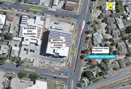
RP-8 RIVERINA DAY SURGERY - COMMUNITY FACILITY DIRECTION SIGNS
Author: Bill Harvey
|
That Traffic Committee endorse the installation of two Community Facility Direction signs, with the words ‘RIVERINA DAY SURGERY’, to be installed at the applicant’s expense, at the intersection of Docker Street and: a Meurant Avenue, indicating west along Meurant Avenue b Chaston Street, indicating west along Chaston Street
|
Report
An application has been received from the Riverina Day Surgery for the installation of two community facility direction signs, displaying the words ‘RIVERINA DAY SURGERY’. It is requested that the signs be located at the intersection of Docker Street and Meurant Avenue, indicating west along Meurant Avenue and Docker Street and Chaston Street, indicating west along Chaston Street.
The front of the Riverina Day Surgery is in Meurant Avenue. There is a short term drop-off and pickup facility with a semi-circular driveway at that location. The main car park for the Riverina Day Surgery is located at the back of the building and accessed from Chaston Street.
It is reasonable to have a community facility direction sign at both locations, given the nature of the facility and the regional significance of the service that it provides. City of Wagga Wagga Policy POL 015 applies to this application. The recommendation is in accordance with the content of that policy.
Risk Management Issues for Council
There are no risks that are associated with this matter.
Internal / External Consultation
Consultation was undertaken with the CEO of the Riverina Day Surgery.
Report submitted to the Traffic Committee on Thursday 13 July 2017. RP-9
RP-9 BEST STREET - MARK PARALLEL PARKING BAYS
Author: Bill Harvey
|
That Traffic Committee endorse the marking of parallel parking bays on the western side of Best Street between number 8 Best Street and 26 Best Street, a length of about 100 metres, in accordance with the provisions of Australian Standard 1742 Part 11 Section 7.1, with the aim of maximising the utilisation of space that is available for on-street vehicle parking in that area.
|
Report
A request has been received for Council to consider marking the parallel parking bays on the western side of Best Street in the vicinity of the Blessed Bean Coffee Shop with the aim of maximising the number of vehicles that are able to use the parallel parking spaces in that area at any one time.
The Blessed Bean Coffee Shop is a popular destination for drivers. Parking on both sides of Best Street is parallel with two travelling lanes of traffic in both directions. There is no off-street parking available for this establishment. Competition for parking in this part of Best Street is shared with drivers who park all-day, normally working in the Baylis Street area. Best Street is the nearest street on the western side of Baylis Street that has no time limitations on parking.
The use of ‘T & L’ type parking bay marks has been used successfully in other parts of the City to maximise the number of vehicles that can be parked within a given area. The manner in which drivers park their vehicles often causes long, unnecessary gaps between vehicles, reducing the number of spaces that are available for use. The recommended solution to this problem is to mark the road seal with an appropriate painted layout, as per the directions in Australian Standard 1742 (Manual of uniform traffic control devices), Part 11 (Parking controls). Section 7.1 deals with ‘Delineation of parking spaces’. The standard indicates that a solid line, encompassing the whole space, need not be used.
Figure 1 - Solid line markings

It is sufficient to mark spaces using L and T markings, as in figure 2.
Figure 2 - Abbreviated markings

Using markings in this way reduces the cost of installing and maintaining the infrastructure.
Risk Management Issues for Council
There are no risks that are associated with this matter.
Internal / External Consultation
Consultation was undertaken with one of Wagga Wagga’s elected Councillors.
Report submitted to the Traffic Committee on Thursday 13 July 2017. RP-10
RP-10 PLUMPTON ROAD AND SPRINGVALE DRIVE - TREATMENT OPTIONS TO ASSIST TURN MOVEMENTS
Author: Bill Harvey
|
That Traffic Committee endorse the following options at the intersection of Plumpton Road with Springvale Drive: a Install a duplicated R1-1 ‘B’ size STOP sign on both sides of Springvale Drive, facing east bound traffic at the intersection with Plumpton Road. b Install a corresponding TF STOP line in conjunction with the sign that is mentioned at point ‘a’, across the face of the intersection of Springvale Drive with Plumpton Road, that complies with the provisions of the Delineation Guide, Section 6.2. c Install a 20 metre length of BB (double unbroken) separation line in the centre of Springvale Drive, commencing at the line mentioned at point ‘b’ and continuing towards the west. d Design and construct an auxiliary right turn facility on the eastern side of Plumpton Road, focused opposite the intersection with Springvale Drive, so as to allow right turning vehicles from Plumpton Road into Springvale Drive to be overtaken on their left side without the overtaking vehicle having to leave the sealed section of the road. |
Report
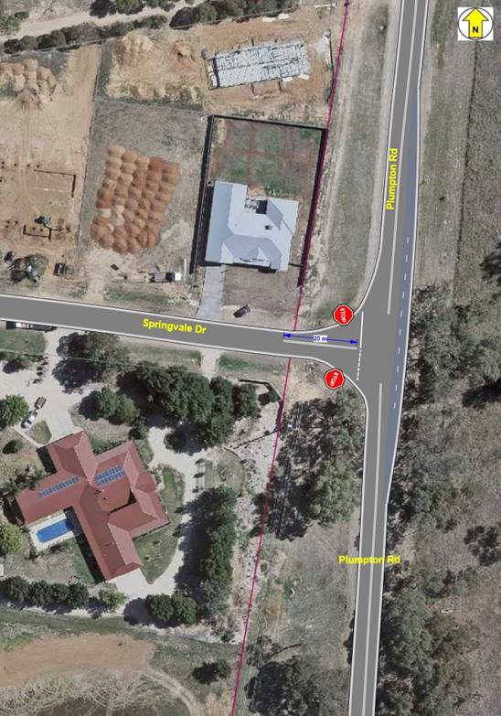
Springvale Drive forms a T junction with Plumpton Road. Springvale Drive is the terminating street, forming the leg of the T. Plumpton Road is the through route, forming the arms of the T. The prevailing speed limit on Plumpton Road is 80 km/h. The speed limit on Springvale Drive is 50 km/h. Springvale Drive is predominantly a residential area with private houses constructed on larger blocks or land. Springvale Drive collects traffic from several other residential streets in that area, providing connection to the broader road network through the intersection with Plumpton Road.
The intersection does not have an adverse crash history.
Traffic volume on Plumpton Road has not been measured at this point however a reasonable estimate of about 5,000 vehicles per day can be made based on counts at a more northerly location. It would be reasonable to estimate that Springvale Drive carries about 1,500 vehicles per day.
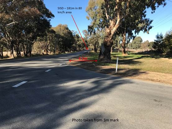
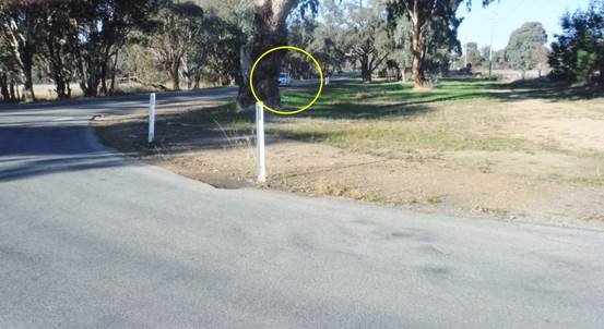
There is a large tree that is located 4.5 metres west of the western edge of the Plumpton Road Seal and 5 metres south of the southern edge of seal of Springvale Drive. While this tree is within the clear zone of 5.5 metres that is indicated in table 4.1 of Part 6 of the Austroads Guide to Road Design, it does not obstruct sight distance from Springvale Drive towards the south when that sight distance is measured as indicated by the Austroads Guide to Road Design, Part 4A, Table 3.1. The Austroads Guide suggests that sight distance should be measured at a point that is 3 metres from the outer edge of the nearest travelling lane of the cross street. The indicated safe intersection sight distance under these circumstances is 181 metres. The actual sight distance, measured in this way, is far greater than the minimum requirement. See the following photograph which was taken from Springvale Drive, toward the south along Plumpton Road.
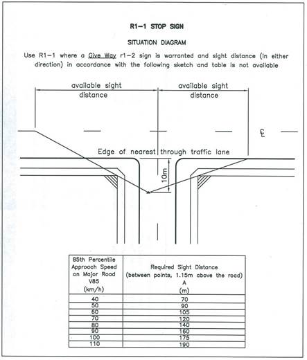
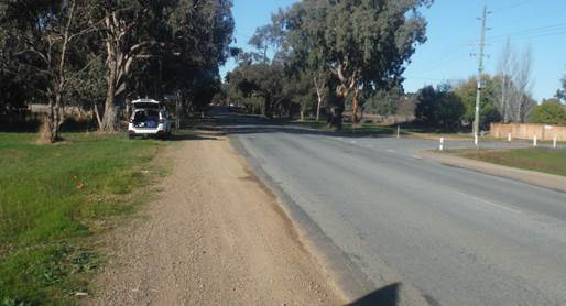
An anomaly occurs when the intersection sight distance is assessed as indicated by Roads and Maritime Services supplementary instructions for the measurement of sight distance when assessing an intersection for the appropriateness of the installation of a STOP sign. Under those circumstances, the sight distance is measured from a point that is 10 metres from the outside edge of the nearest travelling lane. The required sight distance for an intersection when assessed under those criteria is 140 metres.
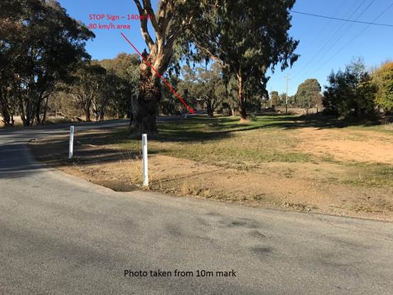
In this instance the sight distance is achieved however the tree does obscure clear sight lines to Plumpton road over a distance that is likely to cause some difficulty for drivers. As indicated by the following photograph, it is possible to lose sight of a vehicle that is well within the required 140 metre limit.
Under these circumstances and to enhance safety at the intersection, it is recommended that a STOP sign control be employed with the TF stop line marked in a position that will allow drivers to stop at the line and have a clear line of sight to the south that is unimpeded by the tree.
There are a significant number of right turn movements from Plumpton Road into Springvale Drive. At the same time, there is a large volume of traffic that continues south in Plumpton Road, towards Gregadoo Road and Lloyd Road. It is very normal to see south bound traffic overtaking right turning vehicles by leaving the sealed bitumen surface and travelling along the eastern shoulder of Plumpton Road. Undue wear to the graded shoulder is evidence of this practice.
Plumpton Rd - view toward south at intersection
Given that development to the south of the city has seen an increase in traffic volume on Plumpton Road it is appropriate to consider a treatment that is likely to enhance the safety of road users at the intersection.
The most likely treatments to address this issue are those which provide an alternate path for drivers who are travelling straight through the intersection from those who are turning right from Plumpton Road into Springvale Road. The two most likely treatments are the construction of either an auxiliary right turn facility or the construction of a channelised right turn lane.
The main difference between the two options that are mentioned above is that an auxiliary right turn facility does not remove the turning vehicle from the path of a driver who is continuing straight through the intersection. The driver who is travelling straight through the intersection, in this case continuing south in Plumpton Road towards Gregadoo or Lloyd Roads, must change direction by veering to the left to overtake the turning vehicle on its near side. In the case of a channelised right turn lane the turning vehicle moves into a lane that has been constructed in the centre of the road to accommodate turning vehicles. A driver who is travelling straight through does not have to change direction to pass the turning vehicle.
Examples of both types of facilities in the local area can be found on Red Hill Road. The intersection of Red Hill Road with Berembee Road is an example of an auxiliary right turn (AUR) facility. The intersection of Red Hill Road with Kimberley Drive is an example of a channelised right turn (CHR) facility.
The Austroads Guide to Road Design Part 4A Unsignalised and Signalised Intersections, discusses the difference between AUR treatments and CHR treatments at sections 4.6 and 4.7. In the case of Plumpton Road and Springvale Drive, where through traffic volume and turning traffic volume do not meet the warrants for a CHR that are detailed at section 4.8 of the Guide, it is suggested that an AUR treatment is appropriate.
The warrant for a CHR on a road with a speed limit under 100 km/h and where traffic volume is 300 vehicles per hour, is 20 right turn movements per hour. Traffic volume on Plumpton Road would only reach 300 vehicles per hour between 8:00am and 9:00am, Monday to Friday. It does not exceed 300 vehicles. The number of right turning vehicles that are required in each hour would not reach 20 except perhaps on rare days. Under normal day time circumstances, when traffic flow on Plumpton Road is not greater than 180 vehicles per hour, the warrant requires 80 right turn movements per hour. That number is certainly never reached.
The following diagram is an indication of the proposed layout for a STOP sign, separation lines and an auxiliary right turn lane. A formal design of road layout and pavement construction is required before the project could proceed to construction.
Risk Management Issues for Council
The intended purpose of this report is to safely manage a risk issue that has been identified and that is detailed in the report.
The risk involved in this matter without any treatment has been assessed as – Major / Unlikely which places it in the – Medium category.
Internal / External Consultation
This matter has been raised by several residents of the Springvale area of the past two years.
Report submitted to the Traffic Committee on Thursday 13 July 2017. RP-11
RP-11 PLUMPTON ROAD - DOUBLE UNBROKEN SEPARATION LINES
Author: Bill Harvey
|
That Traffic Committee endorse the installation of continuous BB (double unbroken) separation lines on Plumpton Road from the intersection with Brindabella Drive to the intersection with Lloyd Road, a length of 1,830 metres.
|
Report
Plumpton Road between the intersection with Brindabella Drive and Lloyd Road has a speed limit of 80 km/h. The road has an average annual daily traffic (AADT) volume of not more than 5,000 vehicles. The road seal is about eight metres in width, divided into one lane in each direction. Shoulders are unsealed and vary from 1.5 to 3.0 metres. The length of road is characterised by a series of T junction type intersections, being Nelson Drive, Springvale Drive, Gregadoo Road and Aspen Road. There is also a horizontal curve that restricts vision between Brindabella Drive and Nelson Drive and a vertical curve that restricts vision between Springvale Drive and Gregadoo Road.
At present there is a centre line that is marked with both a BB (double unbroken) and S1 (broken) separation lines along the length.
Sight distance that is restricted by the horizontal and vertical curves and the regular incidence of intersections suggests that the whole length of 1,830 metres should be marked with a BB separation line to eliminate any incidence of vehicle overtaking.
The set out for longitudinal barrier lines is contained in Australian Standard 1742.2, Section 4.3.3.3 and in table 5.1. The minimum required sight distance on this road is 240 metres with an additional 170 metres required to form BS (single unbroken and broken) barrier line ‘tails’ from each length of BB line. The intervals between curves and intersections on this length of road are such that a consistent BB line is the most appropriate treatment.
Risk Management Issues for Council
The intended purpose of this report is to safely manage a risk issue that has been identified and that is detailed in the report.
The risk involved in this matter without any treatment has been assessed as – Catastrophic / Unlikely which places it in the – High category.
Internal / External Consultation
This matter has arisen as a result of observations that have been made on Plumpton Road by Council Officers.
Report submitted to the Traffic Committee on Thursday 13 July 2017. RP-12
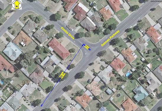
RP-12 KIMBA DRIVE - STOP SIGN AT INTERSECTION WITH DALMAN PARKWAY
Author: Bill Harvey
|
That Traffic Committee endorse the installation of duplicated R1-1 ‘A’ size STOP signs on Kimba Drive facing east bound traffic at the T junction with Dalman Parkway and also a TF painted (STOP) line to be associated with the STOP sign. |
Report
Council Officers were recently asked to investigate the restriction to sight distance at the intersection of Kimba Drive and Dalman Parkway that was caused by a private vehicle that was parked across the nature strip in such a way as to restrict sight distance from Kimba Drive toward the south on Dalman Parkway.
The vehicle was removed by the owner but observations revealed that sight distance when assessed, was impeded by plantings and other assets.
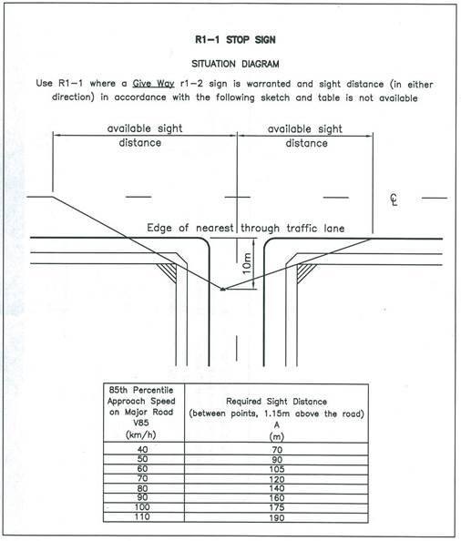
The distance was assessed as per the indication that is contained in the diagram above and found to be less than 90 metres.
It is recommended that a duplicated STOP sign be installed at the intersection to encourage drivers that are turning from Kimba Drive to look carefully for traffic that might be approaching from their right.
Cost
Estimated cost of implementation of this recommendation is $400
Funding for implementation of the recommendation is expected to be sourced from Lines and Signs budget
Risk Management Issues for Council
The intended purpose of this report is to safely manage a risk issue that has been identified and that is detailed in the report.
The risk involved in this matter without any treatment has been assessed as – Major / Possible which places it in the - High category.
Internal / External Consultation
Consultation was undertaken with a resident of Glenfield who uses this intersection on a daily basis.
Report submitted to the Traffic Committee on Thursday 13 July 2017. RP-13
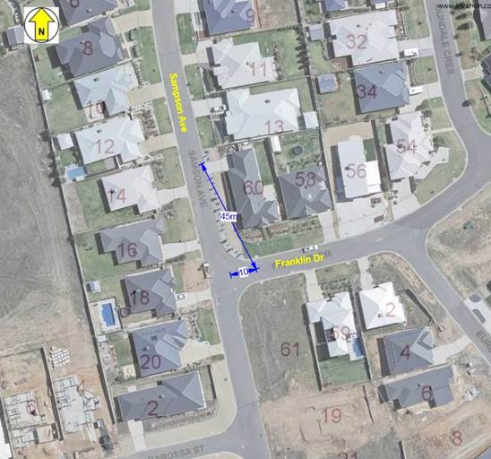
RP-13 FRANKLIN DRIVE - STOP SIGN CONTROL AT THE INTERSECTION WITH SAMPSON AVENUE
Author: Bill Harvey
|
That Traffic Committee endorse the installation of duplicated R1-1 ‘A’ size STOP signs on Franklin Drive facing west bound traffic at the T junction with Sampson Avenue and also a TF painted (STOP) line to be associated with the STOP sign.
|
Report
Council Officers were recently asked to investigate the restriction to sight distance at the intersection of Franklin Drive and Sampson Avenue that is caused by an embankment that restricts sight distance from Franklin Drive toward the north on Sampson Avenue.
An inspection revealed that there is an embankment retaining wall that has been built to facilitate a level building block for the property that is located on the north-east corner of the intersection. There is also a vertical curve in Sampson Avenue, north of the intersection, that restricts sight distance from the intersection in that direction.
The Austroads Guide to Road Design – Part 4A Table 3.2 suggests appropriate safe intersection sight distances on roads with various speed limits. The speed limit on both roads is default urban (50 km/h). Austroads suggests that the required sight distance is 97 metres. The following photograph indicates the view from the intersection at a point that is three metres east of the eastern kerb alignment of Sampson Avenue and at a height of 1.15 metres.

The following photograph is taken in Sampson Avenue from a distance of 97 metres north of the intersection, facing towards Franklin Drive.
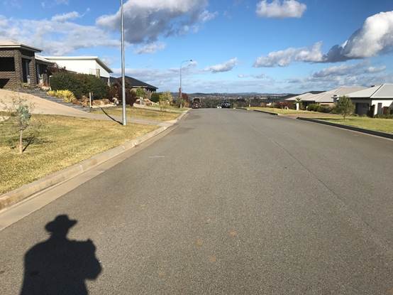
It is clear that the vertical curve causes the sight distance from the intersection to be seriously restricted.
The intersection was then assessed for the use of a STOP sign control, using the criteria that is set by Roads and Maritime Services documentation. See the following diagram.
The required sight distance under these circumstances is 90 metres. The following photograph indicates the actual sight distance that is available is far less than the required distance.
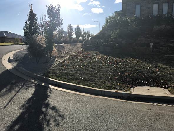
In the absence of the the tree plantings, the maximum sight distance that can be achieved, as a result of the position of the embankment, is 45 metres. Under those circumstances a STOP sign control and associated TF STOP line are warranted at this location.
Risk Management Issues for Council
The intended purpose of this report is to safely manage a risk issue that has been identified and that is detailed in the report.
The risk involved in this matter without any treatment has been assessed as – Major / Possible which places it in the - High category.
Internal / External Consultation
Consultation was undertaken with Council Officers who were responding to a complaint about the tree plantings on the eastern side of Sampson Avenue near the intersection.
Report submitted to the Traffic Committee on Thursday 13 July 2017. RP-14
RP-14 AVOCET DRIVE PEDESTRIAN REFUGE - DA14-0673
Author: Bill Harvey
|
That Traffic Committee members note that the following matter was distributed to members by way of email on 22 May 2017 with members responding in favour of the recommendation. That Traffic Committee endorse the construction of a pedestrian refuge and kerb bulb on Avocet Drive, between intersections with Rainbow Drive and Gunn Drive, subject to the following: a The design that has been proposed complies with the provisions of Roads and Maritime Services Technical Direction 2011/01a. b The pedestrian refuge is constructed as per the design that is contained in the Civil Drawings at page 9 of 22 titled ‘Pedestrian Refuge Layout Plan’. c The applicant must consult with residents and property owners who will be affected by the loss of at-kerb parking on the northern side of Avocet Drive as a result of the construction of the refuge and the installation of the associated restrictive parking signs. d The length of NO STOPPING ZONE on the southern side of Avocet Drive, west of the intersection with Rainbow Drive, should be indicated by using R5-400LR (intermediate NO STOPPING) signs at intervals not greater than 25 metres. |
Report
A development application has been processed in respect of the construction of a shopping centre on the southern side of Avocet Drive and west of Rainbow Drive. A condition of construction was previously set in respect of this development requiring the construction of a pedestrian refuge that crosses Avocet Drive between Rainbow Drive and Gunn Drive.
The applicant has provided a covering letter (attached). See condition numbers 10 and 15 which relate to this matter. A civil construction plan and a site analysis plan have also been attached for consideration. The plan includes the construction of a kerb bulb on the northern side of Avocet Drive so as to reduce the width of the lane that is to be crossed by pedestrians.
Risk Management Issues for Council
The purpose of this report is to safely manage a risk issue that relates to the construction of a shopping centre and the ability of pedestrians to safely cross a road.
The risk involved in this matter without any treatment has been assessed as – Major / Possible which places it in the – High category.
Internal / External Consultation
Consultation has been undertaken with internal Council staff.
Report submitted to the Traffic Committee on Thursday 13 July 2017. RP-15
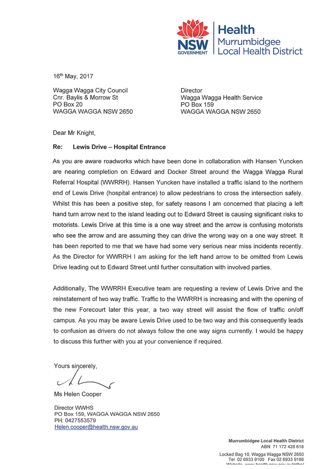
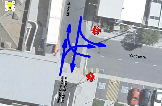
RP-15 LEWIS DRIVE - CHANGE TO TRAFFIC FLOW AND YABTREE STREET - STOP SIGN AT INTERSECTION WITH LEWIS DRIVE
Author: Bill Harvey
|
That Traffic Committee endorse: a Changing the travel direction in Lewis Drive from a one-way street (north to south) to a two-way street between Edward Street and Yabtree Street. b Installation of a STOP sign control for west bound traffic in Yabtree Street at the intersection with Lewis Drive, using duplicated ‘A’ size R1-1 signs facing west bound traffic in Yabtree Street, c Installation of a corresponding TF STOP line in Yabtree Street at the intersection with Lewis Drive, complying with the provisions of the Delineation Guide, Section 6.2. d Removal of all existing signage in Lewis Drive, between Edward Street and Yabtree Street, that suggests that the street is subject to a one-way traffic control. e Installation of an ‘A’ size T2-24 ONE LANE EACH WAY sign facing south bound traffic in Lewis Drive immediately south of the intersection with Edward Street. f Installation of an ‘A’ size R2-6 NO RIGHT TURN sign facing north bound traffic in Lewis Drive on the splitter island at the intersection with Edward Street. |
Report
A request has been received from the Director of Wagga Wagga Rural Referral Hospital seeking consideration of a change to traffic flow arrangements in Lewis Drive between Edward Street and Yabtree Street. The Hospital Executive team are seeking a change that, after completion of the current project that is underway at the front of the Hospital, Lewis Drive be changed to two-way traffic flow, thereby enhancing the free flow of traffic in the area.
Lewis Drive provides access from Edward Street to the Wagga Wagga Rural Referral Hospital. At present and as far as can be remembered, Lewis Drive has been subject to a one-way traffic control arrangement, from north to south. Traffic leaves the area using Doris Roy Lane or Yabtree Street.
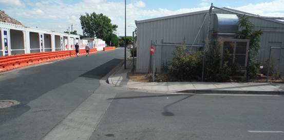
Lewis Drive is 7.5 to 8.0 metres wide in this section with kerb and gutter on both sides. There is access to four car parking areas from Lewis Drive. That is likely to be increased with a further car parking area being established on the site of the old tower block that was recently demolished.
The light green and blue arrows in the following diagram indicate the permitted traffic flow direction in Lewis Drive, Yabtree Street, Doris Roy Lane and Peck Street. The green arrows in Lewis Drive are the only controls that are proposed to be changed as part of this item.

Once the current project that is underway on land adjacent to Lewis Drive has been completed all temporary traffic controls will be removed from the street.
The following diagram indicates the proposed traffic flow directions in this area.
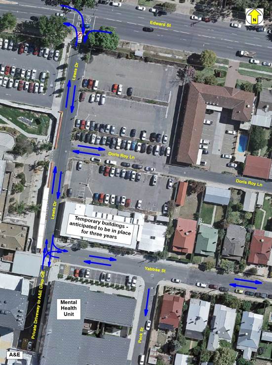
There is currently a group of demountable office buildings on the north-east corner of the intersection of Yabtree Street and Lewis Drive. These buildings cause a significant restriction to sight distance from Yabtree Street towards the north in Lewis Drive. The buildings, although temporary in construction, will be remaining in place for an extended period, estimated to be a further three years. The installation of a STOP sign control facing west bound traffic in Yabtree Street at the intersection with Lewis Drive will facilitate a safe intersection arrangement.
Changing Lewis Drive from one-way to two-way traffic is likely to reduce the volume of traffic that uses the intersection of Lewis Drive and Yabtree Street. Drivers who are leaving the car parks off Lewis Drive will be able to travel north towards Edward Street if they wish.
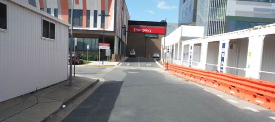
The extension of Lewis Drive, south of the intersection with Yabtree Street, whilst having the appearance of a normal street, is actually a privately owned driveway that provides cul de sac access to the front door of the Accident and Emergency Department for the general public. All traffic must enter and leave through the driveway. The driveway fits the definition of a ‘Road’ as per Road Rules 2014, Rule 12(1) in that it is an area that is open to or used by the public and is developed for, or has as one of its main uses, the driving or riding of motor vehicles. The driveway appears to be a ‘road’ within the meaning of the Regulation and it is reasonable to expect that the rules that apply to the movement of traffic would apply in that area.
It is appropriate to install a T2-24 symbolic ONE LANE EACH WAY sign in Lewis Drive, facing south bound traffic and located near the intersection with Edward Street so as to warn drivers that Lewis Drive is a two-way road.
A splitter island has been constructed at the northern end of Lewis Drive, at the intersection with Edward Street. The design of that island is calculated to encourage any north bound traffic in Lewis Drive to turn left at Edward Street. The splitter island design should be supported by the installation of a NO RIGHT TURN sign facing north bound traffic. Roads and Maritime Services Land Use Coordinator has been engaged in respect of this matter. That Officer advises that Roads and Maritime Services has no objection to vehicular traffic entering Edward Street from Lewis Drive provided that entry is limited to left turn only with right turns discouraged by the shaped splitter island.
Risk Management Issues for Council
The intended purpose of this report is to safely manage a risk issue that has been identified and that is detailed in the report.
The risk involved in this matter without any treatment has been assessed as – Moderate / Likely which places it in the – High category.
Internal / External Consultation
Consultation was undertaken with the Executive Team of Wagga Wagga Rural Referral Hospital and with the Roads and Maritime Services Land Use Coordinator.
|
1⇩. |
Letter from MLHD re Lewis Drive |
|
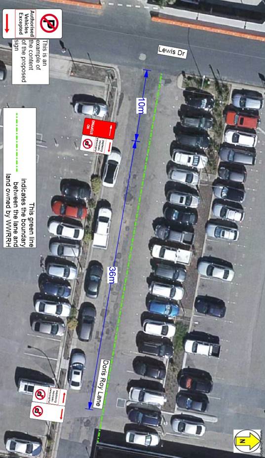
RP-16 DORIS ROY LANE - CHANGES TO PARKING CONTROLS
Author: Bill Harvey
|
That Traffic Committee endorse the installation of a 36 metre length of conditional NO PARKING zone, using standard R5-40 series signs, on the southern side of Doris Roy Lane immediately east of the statutory 10 metre length of NO STOPPING zone that is immediately east of the intersection with Lewis Drive, with the additional words ‘AUTHORISED VEHICLES EXCEPTED’ included on the signs, as indicated in the diagram that is contained in the report. |
Report
The length of kerb that is the subject of this recommendation has previously been available for unrestricted parallel parking. It has temporarily been converted to a NO PARKING zone while work has been undertaken on the western side of Lewis Drive to demolish the old tower block of the Base Hospital.
When the project that is being undertaken on the western side of Lewis Drive is complete an additional car parking area will be available for use by the public but with about 20 spaces reserved for use by vehicles that are owned by the Murrumbidgee Local Health District (MLHD) and NSW Health. Once that car park is opened, the reserved parking that was made available for authorised vehicles on the eastern side of Peck Street will become unrestricted parallel parking. The Peck Street area has been used by MLHD to accommodate vehicles that are driven by visiting medical officers (VMO’s). VMO’s have been given printed authorities to be displayed in their vehicles, enabling them to lawfully park in Peck Street by arrangement with Council.
The Director of Wagga Wagga Rural Referral Hospital has asked if the above mentioned length of Doris Roy Lane might be made available for parking VMO’s vehicles when Peck Street is no longer available. The alternative that is available to MLHD is to reserve six of the 90° angle spaces on the northern side of Doris Roy Lane for exclusive use by VMO’s. The property boundary between the road reserve and land that is controlled by MLHD and used as a car park is indicated on the following diagram by a broken green line. All land to the north of the line is owned by the Hospital. If there is an agreement to allow authorised vehicles to park on the southern side of Doris Roy Lane, then the 90° angle parking will remain as unrestricted parking.
Risk Management Issues for Council
There are no risks that are associated with this matter.
The risk involved in this matter without any treatment has been assessed as – Rare / Insignificant which places it in the – LOW category.
Internal / External Consultation
Consultation was undertaken with the Director of the Wagga Wagga Rural Referral Hospital.
Report submitted to the Traffic Committee on Thursday 13 July 2017. RP-17
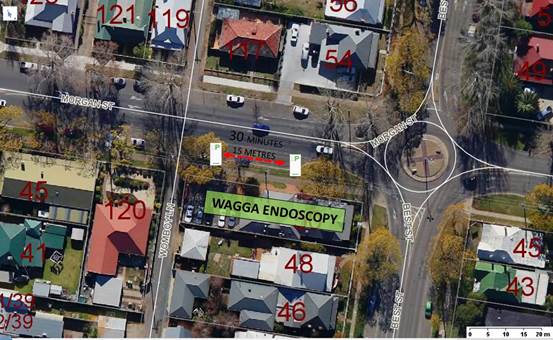
RP-17 MORGAN STREET - TIMED PARKING NEAR BEST STREET
Author: Bill Harvey
|
That Traffic Committee endorse the installation of a 15 metre length of timed parking zone using standard R5-1-1 series signs with the following words displayed: ½P 8:30am – 6pm Mon to Fri On the southern side of Morgan Street between Best Street and Womboy Lane, beside number 50 Best Street. |
Report
A request has been received from a member of the public for consideration of the implementation of a length of short of timed parking in Morgan Street adjacent to 50 Best Street which is the Wagga Wagga Endoscopy Centre. That particular practice operates as a short term health facility has a large number of older patients who visit the centre. Patients are dropped at the centre in the morning and picked up in the afternoon after undergoing a medical procedure. In almost all cases the patient has been anaesthetised to some degree and has some difficulty in walking safely, particularly elderly patients.
The Endoscopy Centre has off-street parking that is suitable for drop off and pickup however elderly patients prefer to be picked up from as close as possible to the front door in Morgan Street. The short length of kerb between the western side of the intersection with Best Street and Womboy Lane is very suitable for this purpose. The length, being 15 metres, would normally only accommodate two vehicles parked at kerb.
At the present time that length of untimed parking space is most often used by drivers who are parking all day while they work in and around Baylis Street. The additional distance that an able bodied person will be forced to walk as a result of losing this length is negligible.
Conversion of this length to ½ hour timed parking, Monday to Friday, when the Endoscopy Centre operates, is an appropriate use of the parking resource.
Risk Management Issues for Council
There are no risks that are associated with this matter.
Internal / External Consultation
Consultation was undertaken with a member of the public and also with the Endoscopy Centre management who are in favour of the change.