Agenda
and
Business Paper
To be held on
Monday 22
March 2021
at 6.00pm
Civic Centre cnr
Baylis and Morrow Streets,
Wagga Wagga NSW 2650 (PO Box 20)
P 1300 292 442
P council@wagga.nsw.gov.au
wagga.nsw.gov.au
Agenda
and
Business Paper
To be held on
Monday 22
March 2021
at 6.00pm
Civic Centre cnr
Baylis and Morrow Streets,
Wagga Wagga NSW 2650 (PO Box 20)
P 1300 292 442
P council@wagga.nsw.gov.au
wagga.nsw.gov.au
NOTICE OF MEETING
In pursuance of the provisions of the Local Government Act, 1993 and the Regulations there under, notice is hereby given that an Ordinary Meeting of the Council of the City of Wagga Wagga will be held in the Council Chamber, Civic Centre, Corner Baylis and Morrow Streets, Wagga Wagga, on Monday 22 March 2021 at 6.00pm.
Council live streams video and audio of Council meetings. Members of the public are advised that their voice and/or image may form part of the webcast.

Mr Peter Thompson
General Manager
WAGGA WAGGA CITY COUNCILLORS
|
Mayor Councillor Greg Conkey OAM |
Deputy Mayor Councillor Dallas Tout |
Councillor Yvonne Braid |
Councillor Paul Funnell |
|
Councillor Dan Hayes |
Councillor Vanessa Keenan |
Councillor Rod Kendall |
Councillor Tim Koschel |
|
Councillor Kerry Pascoe |
|
|
|
QUORUM
The quorum for a meeting of the Council is a majority of the Councillors of the Council who hold office for the time being who are eligible to vote at the meeting.
COUNCIL MEETING ROOM
Reports submitted to the Ordinary Meeting of Council to be held on Monday 22 March 2021.
Ordinary Meeting of Council AGENDA AND BUSINESS PAPER
Monday 22 March 2021
PRAYER 3
ACKNOWLEDGEMENT OF COUNTRY 3
APOLOGIES 3
Confirmation of Minutes
CM-1 Ordinary Council Meeting - 8 March 2021 3
DECLARATIONS OF INTEREST 3
Reports from Staff
RP-1 DA20/0774 - Change of Use to Centre Based childcare facility (60 places) including associated alterations and additions, signage, landscaping and boundary fencing AT 133 PETER STREET, WAGGA WAGGA 4
RP-2 Planning Proposal - LEP20/0006 - Currawang Drive - Amendment to land zoning and minimum lot size of the Wagga Wagga Local Environmental Plan 2010 9
RP-3 Planning Proposal - LEP19/0010 to amend Wagga Wagga Local Environmental Plan 2010 minimum lot size provisions for land bound by Silverwood, Birch, Mitchell and Brunskill Roads, Lake Albert 19
RP-4 Planning Proposal - LEP20/0010 - Amend Wagga Wagga Local Environmental Plan Height of Building Control at 63-65 Johnston Street, Wagga Wagga 32
RP-5 Friday night shopping and footpath activation trial 38
RP-6 DRAFT Wagga Wagga Major Overland Flow Floodplain Study (MOFFS) & The Tarcutta, Ladysmith and Uranquinty Floodplain Study (VOFFS) 42
RP-7 FINANCIAL PERFORMANCE REPORT AS AT 28 FEBRUARY 2021 50
RP-8 Section 356 Requests for Financial Assistance 88
RP-9 COVID-19 Fast Track Event Sponsorship 92
RP-10 COUNCILLOR CONFERENCE - MURRAY DARLING ASSOCIATION NATIONAL CONFERENCE AND ANNUAL GENERAL MEETING 96
RP-11 RESOLUTIONS AND NOTICES OF MOTIONS REGISTERS 98
Committee Minutes
M-1 FLOODPLAIN RISK MANAGEMENT ADVISORY COMMITTEE - MINUTES - EXTRAORDINARY MEETING 23 FEBRUARY 2021 100
QUESTIONS/BUSINESS WITH NOTICE 108
Confidential Reports
CONF-1 PROPERTY RATES MATTER 109
CONF-2 Lake Albert Blue Green Algae Remediation (Update on Extended trial of Ultrasound Units) 110
CONF-3 RFT2018-16 PROVISION OF TRADE SERVICES (REFRESH) 111
CONF-4 RFT2021-16 SUPPLY OF MEMORIAL PLAQUES, VASES AND OTHER SUPPLIES 112
CONF-5 Proposed Assignment of Airport Sub-Lease - Light Aircraft Precinct Hangar Site 18 113
PRAYER
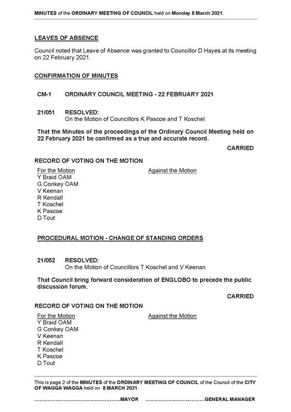
CM-1 Ordinary Council Meeting - 8 March 2021
|
That the Minutes of the proceedings of the Ordinary Council Meeting held on 8 March 2021 be confirmed as a true and accurate record.
|
|
1⇩. |
Minutes - 8 March 2021 |
114 |
|
Report submitted to the Ordinary Meeting of Council on Monday 22 March 2021 |
RP-1 |
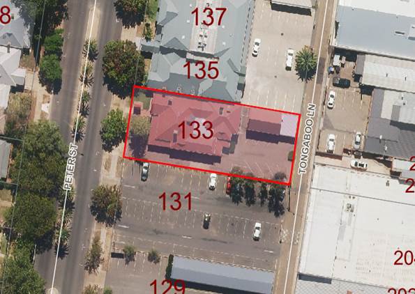
RP-1 DA20/0774 - Change of Use to Centre Based childcare facility (60 places) including associated alterations and additions, signage, landscaping and boundary fencing AT 133 PETER STREET, WAGGA WAGGA
Author: Paul O'Brien
General Manager: Peter Thompson
|
Summary: |
The report is for a development application and is presented to Council for determination. The application has been referred to Council under Section 1.11 of the Wagga Wagga Development Control Plan 2010 (DCP) as the application includes a variation to a control and to which a submission has been received.
It is proposed to vary the off-street parking control requirement under Clause 2.2. This control requires 15 off-street parking spaces whereas the development proposes 5.
The details of the submission and justification for the required variation are contained within the attached Section 4.15 Assessment Report.
|
|
That Council approve DA20/0774 for Change of Use to Centre Based childcare facility (60 places) including associated alterations and additions, signage, landscaping and boundary fencing at 133 Peter Street, Wagga Wagga NSW 2650 subject to the conditions outlined in the Section 4.15 Assessment Report.
|
Development Application Details
|
Applicant |
Exceeding Pty Ltd |
|
Owner |
Robert Leslie Davies, Thomas John Davies, (Directors) Arockette Pty Ltd & Kenzala Pty Ltd |
|
Development Cost |
$275,000 |
|
Development Description |
Change of Use to Centre Based childcare facility |
Report
Key Issues
Variation to DCP Control Clause 2.2 - Off street parking - the control requires 15 off street parking spaces and five spaces are proposed.
Site Location
The site is located on the eastern side of Peter Street, it is uniform in shape extending to 1012sq.m. There is an existing commercial premises on site with rear lane access and parking to Tongaboo Lane.
Assessment
The application is for a change of use from an existing commercial premises within the commercial core to a child care facility accommodating a maximum of 60 children. The use is one that is permitted with consent in the B3 (commercial core) zone.
The development requires minor alterations and additions to the premises and includes significant landscaping throughout the site. The proposed works are to ensure that the centre complies with the applicable national regulations and guidelines for child care centres and includes items such as minimum indoor and outdoor play spaces.
As a result of the proposed works two existing car parking spaces to the side of the building will be removed. Five car parking spaces are to be laid out at the rear of the site and these will be accessed from Tongaboo Lane.
There is a shortfall of parking on site, a variation has been requested and justified by the applicant and is summarised below:
· The alterations and additions proposed as part of this application limits the availability of on-site parking given the building envelope is to be retained in addition to the provision of indoor and outdoor play areas required by the Education Regulations
· The reliance of on-street parking for visitors and alternative transport arrangements for staff is considered to be a superior outcome as opposed to dominating the subject site with hard paved areas (as is existing).
· The provision of high quality landscaping throughout the site and reduced parking will ensure the character of the built form and surrounding locality will be retained.
· The proposal will remove the existing driveway from Peter Street and will therefore afford the public domain an additional on-street parking space.
· The subject site is located within the Commercial Core which will also encourage dual purpose trips either to nearby work places or to the various retail, commercial, community and recreational facilities within close proximity to the site.
· The site is readily accessible by foot to the surrounding residential neighbourhoods and purposely includes a pram storage area for those choosing to walk to the centre.
In addition to the above points both the LEP and DCP include controls that support the primacy of the commercial core and encourage developments that are accessible by different modes of transport. The subject site is very accessible and within a central location that is accessible to a number of alternative parking options. The proposed child care centre in the B3 Commercial Core zone helps to ensure the ongoing primacy and vibrancy of the Wagga Wagga Central Business District. A vibrant CBD is in the public interest as it provides a desirable place for people to interact and socialise in an accessible location.
Meeting car parking requirements in the CBD is not a problem exclusive to this development. Strict application of parking controls would effectively preclude any reasonable development on sites such as this close to the commercial core. The zoning of the land B3 - Commercial Core in itself implies that development of the land, from its historic residential use, to commercial uses is desired and anticipated. Therefore, to support the use of the land for its intended purposes under the WWLEP 2010, irrespective of the proposed development, some variation to parking requirements is likely to be required. The variation to parking is therefore supported.
The centre will open between the hours of 6am and 6pm Mondays to Saturdays with any use of the outdoor areas restricted prior to 7am. These hours are comparable to many other approved centres and entirely suitable within the central area. Proposed boundary fencing and landscaping will complement the existing property and add character to the streetscape.
One submission has been received to the development and this has been detailed and addressed within the attached s4.15 assessment report.
The child care centre is not anticipated to result in any detrimental impacts to the surrounding locality or streetscape and is recommended for approval subject to conditions that are outlined in the attached report.
Reasons for Approval
1. The proposed development is consistent with the provisions of the State Environmental Planning Policy (Educational Establishments and Child Care Facilities) 2017;
2. The proposed development is consistent with the provisions of the Wagga Wagga Local Environmental Plan 2010;
3. The applicable objectives of Sections 2 and 12 of the DCP are satisfied by the proposed development;
4. The proposed variation to the off-street parking pursuant to Clause 2.2 of the DCP has been justified;
5. For the abovementioned reasons it is considered to be in the public interest to approve this development application.
Financial Implications
N/A
Policy
Wagga Wagga Local Environmental Plan 2010
Wagga Wagga Development Control Plan 2010
Link to Strategic Plan
The Environment
Objective: We plan for the growth of the city
Outcome: We have sustainable urban development
Risk Management Issues for Council
Refusal of the application may result in an appeal process in the Land and Environment Court which will have to be defended by Council. The reasons for refusal will have to be justified and withstand scrutiny and cross examination in Court.
Approval of the application is not considered to raise risk management issues for Council as the proposed development is generally consistent with LEP and DCP controls and the proposed variation has been fully assessed and justified.
Internal / External Consultation
Full details of the consultation that was carried out as part of the development application assessment is contained in the attached s4.15 Report.
|
|
|
Media |
Community Engagement |
Digital |
|||||||||||||
|
Rates notices insert |
Direct mail |
Letterbox drop |
Council news story |
Council News advert |
Media releases |
TV/radio advertising |
One-on-one meetings |
Your Say website |
Community meetings |
Stakeholder workshops |
Drop-in sessions |
Surveys and feedback forms |
Social media |
Email newsletters |
Website |
Digital advertising |
|
|
TIER |
|||||||||||||||||
|
Consult |
|
x |
|
x |
|
|
|
|
|
|
|
x |
|
||||
|
Involve |
|
|
|
|
|
|
|
|
|||||||||
|
Collaborate |
|
|
|
|
|
|
|
|
|
|
|
|
|
|
|
|
|
|
1. |
DA20/0774 - Section 4.15 Report - Provided under separate cover |
|
|
2. |
DA20/0774 - Plans - Provided under separate cover |
|
|
3. |
DA20/0774 - Statement of Environmental Effects - Provided under separate cover |
|
|
4. |
DA20/0774 - Traffic and Parking Assessment - Provided under separate cover |
|
|
5. |
DA20/0774 - Noise Impact Assessment - Provided under separate cover |
|
|
6. |
DA20/0774 - Plan of Management - Provided under separate cover |
|
|
7. |
DA20/0774 - Redacted submission - Provided under separate cover |
|
|
Report submitted to the Ordinary Meeting of Council on Monday 22 March 2021 |
RP-2 |
RP-2 Planning Proposal - LEP20/0006 - Currawang Drive - Amendment to land zoning and minimum lot size of the Wagga Wagga Local Environmental Plan 2010
Author: Crystal Atkinson
Director: Michael Keys
|
Summary: |
Council is in receipt of a planning proposal to rezone land from RU1 Primary Production to R5 Large Lot Residential and reduce the minimum lot size from 200 hectares to 2 hectares for 39 Currawang Drive, Springvale.
The recommendation is to support the planning proposal and expand the reduction of minimum lot size to a broader precinct to acknowledge the existing lot size pattern. If endorsed, the planning proposal, with Council’s addendum will be submitted to the NSW Department of Planning and Environment for Gateway Determination. |
|
That Council: b prepare an addendum to the application to expand the change in minimum lot size as identified in the report to c submit the planning proposal with Council’s addendum to the NSW Department of Planning, Industry and Environment for Gateway Determination e receive a further report after the exhibition period addressing any submission made in respect of the planning proposal |
|
Submitted planning proposal |
Council is in receipt of a planning proposal (LEP20/0006) to rezone land at 39 Currawang Drive, Springvale from RU1 Primary Production to R5 Large Lot Residential and reduce the minimum lot size provisions from 200 hectares to 2 hectares. |
|
Applicant |
Aaron De Jong |
|
Land Owners |
Refer to confidential attachment |
Proposal
Council is in receipt of a planning proposal to amend the Wagga Wagga Local Environmental Plan 2010 (WWLEP) to:
1. Rezone land from RU1 Primary Production to R5 Large Lot Residential
2. Reduce the minimum lot size from 200 hectares to 2 hectares
The purpose of the planning proposal is to provide subdivision opportunities for land adjoining an existing large lot residential area. The land is located directly west of the Springvale large lot residential area and is currently zoned RU1 Primary Production and used for agricultural purposes.
The proposal area is approximately 40 hectares and will create an opportunity for approximately 16 large lot residential lots.
The changes proposed in the application will be achieved by amending the land zoning and minimum lot size maps to reflect the outcomes shown in figures 1 and 2 below.
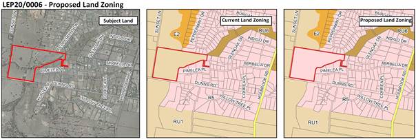
Figure 1: Proposed Land Zoning Changes
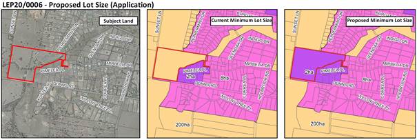
Figure 2: Proposed Minimum Lot Size Changes
Recommended amendments
An assessment of the large lot residential precinct north of Dunns Road where an 8-hectare minimum lot size provision is applied shows the lot sizes to be predominantly 2 hectares. The lot size breakup of the precinct is shown in figure 4 and consists of the following:
§ 59 lots less than 2 hectares – no subdivision potential
§ 17 lots less than 3 hectares – no subdivision potential
§ 2 lots less than 4 hectares – no subdivision potential
§ 1 lot greater than 4 hectares – potential for 1 additional lot
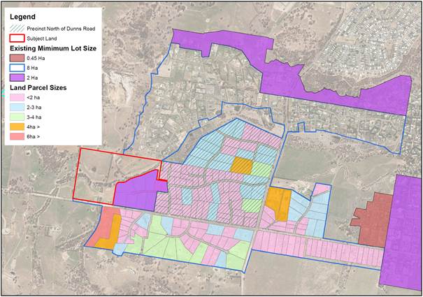
Figure 4: Lot size assessment
Based on the existing lot pattern, available services, and character of the area, it is proposed to expand the proposed reduction in minimum lot size to the precinct north of Dunns Road as shown in figure 5. Expanding the 2-hectare minimum lot size to this location will acknowledge the existing lot size pattern of the area.
Progressing with a minimum lot size of 2-hectares will not result in significant changes to the existing lot pattern and can allow for consideration of smaller lot size in the future if appropriate.
The precinct south of Dunns Road has slightly different lot size pattern and could be considered as part of a separate proposal.
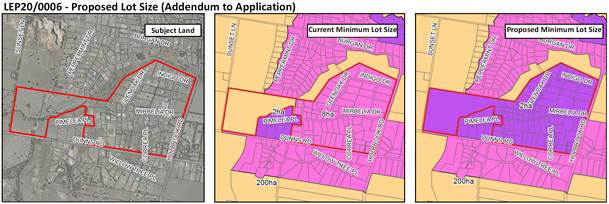
Figure 5: Proposed expansion of minimum lot size amendments
Site and Locality
The site is located north of Dunns Road and is a direct extension of the Springvale large lot residential area. The site will form part of the southern fringe large lot residential area.
Key Considerations
The planning proposal has been assessed against Council’s strategies, policies and guidelines, the NSW Department of Planning, Industry and Environment’s Guideline for preparing planning proposals and the Ministerial Directions. The key considerations are identified below and the full assessment report is provided as attachment 2.
1. Council’s Vision or Strategic Intent
There is general support for the planning proposal in both local and regional policies.
· Riverina Murray Regional Plan 2036
The Riverina Murray Regional Plan 2036 (RMRP) outlines goals to both protect the region’s diverse and productive agricultural land and promote the growth of regional cities and local centres.
Whilst the planning proposal intends to rezone land currently zoned RU1 Primary Production, the opportunities to pursue viable agricultural uses are limited due to the character and size of the lot and its proximity to an existing large lot residential precinct.
The proposal will promote the growth of regional cities and local centres by increasing the supply of housing within the city.
· Wagga Wagga Spatial Plan 2013-2043
While the Wagga Wagga Spatial Plan2013-2043 (Spatial Plan) has been replaced with the Wagga Wagga Local Strategic Planning Statement – Wagga Wagga 2040 (LSPS), it is considered as the application was lodged prior to the LSPS being adopted on 8 February 2021.
The land was not identified for ‘potential intensification’ in the Spatial Plan, however, is located adjacent to an area identified for ‘potential intensification’ and partially located within an area identified as ‘potential urban land’.
The plan seeks to identify sites suitable for redevelopment and investigate the potential to concentrate development to infill sites to accommodate future growth and that development is to occur in liaison with infrastructure providers to ensure efficient and cost effective provision of services. The proposal is consistent with this.
The addition of dwellings to the housing stock is a major driver of population growth in the city, providing opportunities for households to relocate from other areas or new households to form locally. At a growth rate of 1.2%, the population of Wagga Wagga will exceed 80,000 people in 2040, however the city must plan to grow beyond 100,00 people. To accommodate this growth, the city will need to accommodate an additional 14,000 homes.
The supply of residential land was considered in the plan that identified there was approximately 426 hectares of urban release area. At a density pattern of 8 dwellings per hectare, the plan identified that this land could accommodate an additional 3,500 dwellings and the greenfield areas would be able to accommodate 10 years of supply of housing at the projected growth rate. This planning proposal will contribute to increasing our supply of housing.
· Wagga Wagga Local Strategic Planning Statement – Wagga Wagga 2040
At the time the application was lodged, the LSPS was being developed, but had not yet been on public exhibition. Since the application was lodged, public exhibition of the LSPS occurred and the plan was adopted on 8 February 2021.
The planning proposal did not need to address the LSPS, but an assessment of consistency with key themes and priorities is provided in this assessment.
Consideration of areas not identified for growth:
The LSPS provides opportunities for consideration of areas not identified for growth in the plan and any proposal is to address the principles of the LSPS including service provision, accessibility, and connectivity.
For the purposes of this proposal, this assessment addresses this.
Connected and accessible city:
Connectivity across the city supports an attractive lifestyle through reduced travel time and congestion. In the LSPS the objective is to direct greenfield development to identified growth areas integrated into transport networks and enabling infill development near key locations of the city.
Whilst development in this location is not an identified greenfield development area or infill within proximity to key service, it is a direct extension of an existing large lot residential area and within a 15-minute drive of the CBD.
Growth is supported by sustainable infrastructure:
Development in this location will make use of existing infrastructure services.
Protect and enhance natural areas and corridors:
The planning proposal is accompanied by an initial biodiversity assessment where it concludes that ‘one endangered ecological community occurs within the proposal area and a number of threatened species may potentially occur in the proposal area and based on preliminary design concept, a significant impact to threatened species or ecological communities, or their habitats is considered unlikely’.
The planning proposal indicates that the Biodiversity Conservation Act 2016 thresholds will be exceeded, and a Biodiversity Development Assessment Report (BDAR) will be required as part of any future development application. The biodiversity assessment provided concludes that exceedance of thresholds could be avoided removing the need for a BDAR assessment.
Manage growth sustainably:
The initial biodiversity assessment provided with the planning proposal concludes that significant impacts to threatened species or ecological communities, or their habitats is considered unlikely and that development can avoid triggering the requirement for a BDAR by avoiding wooded vegetation including paddock trees.
Provide for a diversity of housing that meets our needs:
While large lot residential development is to be restricted on the fringe to support future investigation of expansion reliant on infrastructure capacity, the proposal has indicated adequate infrastructure capacity is available to support the proposal. The southern fringe of the city has expansive areas of large lot residential development and while desirable for many residents, this style of development complicates service delivery, transport planning and future development patterns. Development of additional large lot residential lots in this location is a direct extension of an existing large lot residential precinct and will increase supply of this type of housing in a location that is not restricting future growth potential.
Increase resilience to natural hazards and land constraints:
The site has an overland flow path running from the north-eastern corner to the southern boundary of the site. This risk can be managed through subdivision design.
2. Infrastructure
· Stormwater
A hydrology report accompanies the planning proposal assessing the drainage system of the subject area. The report provides comparison of the existing and developed land conditions in terms of peak flow rate and time of concentration. These comparisons show peak flow rate to be higher for the developed case, whereas the time of concentration is lower for most of the cases due to the impervious ratio increasing as a result of development leading to higher runoff coefficient and consequently higher flow rate. The report indicates that the higher flow rate means higher velocity of flow and less time of concentration needed for overland rainfall to flow through the path distance and when flow path distances increase after construction, a longer time of concentration is likely to occur.
A stormwater management strategy will need to accompany any development application addressing the final subdivision layout.
· Water
The application has indicated that reticulated water supply will be provided to the development with potential for restrictions to apply to some lots based on elevation.
During public exhibition, it is proposed to consult with Riverina Water County Council on the provision of water and potential restrictions identified.
· Sewer
The planning proposal indicates that the existing sewer network has capacity to accommodate the proposed development and augmentation of sewer infrastructure will be funded by the developer.
· Utilities
Electricity, gas, and telecommunications services are available to the subject site.
· Traffic
Access to the site is limited due to existing lot layouts on Currawang Drive and Pimelea Place. The preferred option is to extend the Pimelea Place cul-de-sac to the subject site, however, it is acknowledged that land acquisition may be challenging to achieve this.
The next option is to have direct access to Dunns Road, noting the proposed upgrades scheduled and funded for Dunns Road. The access location will need to be located away from crests on Dunns Road to ensure adequate site distances for all traffic. The preferred access location is to be located at the eastern end of the site’s frontage to Dunns Road if this option is pursued.
Access will be specified as objectives and controls in a precinct section of the DCP for this site.
3. LEP Provisions
· Exiting provisions
The site is currently zoned RU1 Primary Production with a minimum lot size of 200 hectares. Whilst the site is below the current minimum lot size, there is a dwelling located on the lot.
The current use of the land is rural.
· Proposed provisions
The proposed changes to the LEP will enable the subdivision of the site into approximately 16 lots.
4. Development Control Plan
· Existing controls
Development of the subject site is currently undertaken in accordance with the rural provisions of the Wagga Wagga Development Control Plan 2010.
The proposed R5 Large Lot Residential area will trigger application of section 5.3 of the DCP which specifies native vegetation requirements. This section applies to land where the lot size is greater than 0.2 hectares. The minimum lot size proposal of 2 hectares will allow adequate site area to address native vegetation planting requirements.
· Master plan / site specific controls?
Given the access requirements, it is proposed to prepare site specific provisions for the DCP to be exhibited alongside the planning proposal.
Financial Implications
It is anticipated that the LEP amendments will result in new development on the subject land in the future. This has financial implications for Wagga Wagga City Council.
Section 7.11 of the Environmental Planning Assessment Act 1979 and Council’s contributions plans enables Council to levy contributions, where anticipated development will or is likely to increase the demand for public facilities.
Section 64 of the Local Government Act 1993, Section 306 of the Water Management Act 2000 as well as Council’s development servicing plans enable Council to levy developer charges based on the increased demands that new development will have on sewer and/or stormwater.
The contribution and development servicing plans will apply to any future development of the land.
Policy and Legislation
Environmental Planning and Assessment Act 1979
Wagga Wagga Local Strategic Planning Statement – Wagga Wagga 2040
Wagga Wagga Local Environmental Plan 2010
Link to Strategic Plan
The Environment
Objective: We plan for the growth of the city
Outcome: We have sustainable urban development
Risk Management Issues for Council
The planning proposal has been assessed and it is recommended it be submitted to NSW Department of Planning, Industry and Environment for Gateway Determination. If issued, the determination will require public and agency consultation. Consultation may highlight issues not evident during the assessment.
Internal / External Consultation
Formal public consultation with agencies, adjoining landowners and the general public will occur if Gateway Determination is received.
An engagement plan for the planning proposal is attached to this report (Attachment 3).
Proposed consultation methods are indicated in the table below:
|
|
|
Media |
Community Engagement |
Digital |
|||||||||||||
|
Rates notices insert |
Direct mail |
Letterbox drop |
Council news story |
Council News advert |
Media releases |
TV/radio advertising |
One-on-one meetings |
Your Say website |
Community meetings |
Stakeholder workshops |
Drop-in sessions |
Surveys and feedback forms |
Social media |
Email newsletters |
Website |
Digital advertising |
|
|
TIER |
|||||||||||||||||
|
Consult |
|
x |
|
x |
|
|
x |
|
|
|
x |
x |
|
||||
|
1. |
LEP20/0006 - Application to amend Wagga Wagga Local Environmental Plan 2010 - Provided under separate cover |
|
|
2. |
LEP20/0006 - Assessment Report - Provided under separate cover |
|
|
3. |
Engagement Plan - Provided under separate cover |
|
|
4. |
Land Owner Details This matter is considered to be confidential under Section 10A(2) of the Local Government Act 1993, as it deals with: personnel matters concerning particular individuals. - Provided under separate cover |
|
|
Report submitted to the Ordinary Meeting of Council on Monday 22 March 2021 |
RP-3 |
RP-3 Planning Proposal - LEP19/0010 to amend Wagga Wagga Local Environmental Plan 2010 minimum lot size provisions for land bound by Silverwood, Birch, Mitchell and Brunskill Roads, Lake Albert
Author: Crystal Atkinson
Director: Michael Keys
|
Summary: |
At the Ordinary Meeting of Council on 10 August 2020, Council resolved to support a planning proposal and seek Gateway Determination from NSW Department of Planning, Industry and Environment. The planning proposal sought to amend the minimum lot size provisions of the Wagga Wagga Local Environmental Plan 2010 applicable to land bound by Silverwood, Birch, Mitchell and Brunskill Roads, Lake Albert.
Council received a Gateway Determination from the NSW Department of Planning, Industry and Environment on 16 September 2020 to proceed with the above-mentioned planning proposal subject to public exhibition.
The planning proposal and associated Wagga Wagga Development Control Plan 2010 amendment was on public exhibition from 9 January to 20 February 2021 (inclusive).
The purpose of this report is to provide feedback on the public consultation and submissions received. The report also requests adoption and gazettal of the amendment to the Wagga Wagga Local Environmental Plan 2010 and adoption of the amendment to the Wagga Wagga Development Control Plan 2010. |
|
That Council: a note the results of the public exhibition for planning proposal LEP19/0010 b adopt planning proposal LEP19/0010 to amend the Wagga Wagga Local Environmental Plan 2010 c gazette the plan and notify landowners and NSW Department of Planning, Industry and Environment of the decision d adopt the amendments to the Wagga Wagga Development Control Plan 2010 and provide notification of the adoption in the local paper |
|
Submitted proposal: |
Amendment to Wagga Wagga Local Environmental Plan 2010 (LEP19/0010) to change the minimum lot size for land bound by Silverwood Rd, Brunskill Rd, Birch Rd and Mitchell Rd, Lake Albert (illustrated figure 1). |
|
Applicant: |
Salvestro Planning |
|
Land Owners: |
Refer to confidential cover |
Council is in receipt of an application to amend the Wagga Wagga Local Environmental Plan 2010 (LEP) to reduce the minimum lot size provisions for lots bounded by Brunskill, Mitchell, Silverwood and Birch Roads from 2ha to a combination of lots sizes including 0.15ha, 0.2ha, 0.3ha and 0.4ha.
The area is an existing large lot residential area on south-eastern fringe of the city.
The planning proposal proposes to amend the minimum lot size map to reflect the range shown below:
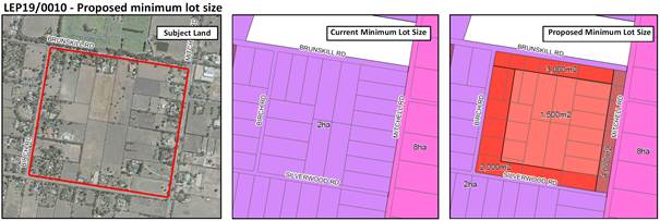
Figure 1: Minimum Lot Size Changes
The aim of the proposal is to increase residential density in an existing large lot residential area whilst respecting the existing character and adjoining land uses. The proposed amendment to the WWLEP2010 will result in an additional 150 residential allotments.
Site and Locality
The site is a large lot residential site bound by Silverwood, Mitchell, Brunskill and Birch Roads in Lake Albert, which is approximately 47ha. It is approximately 2km east of Lake Albert, 7km south east of the CBD and 6km west of the airport (illustrated in Figure 2).
The existing character is defined by rural residential allotments that are 5 -20 hectares. To the north of the site is the lawn cemetery. The block is slightly undulating, predominately cleared and is suitable for a more intensive residential built environment.
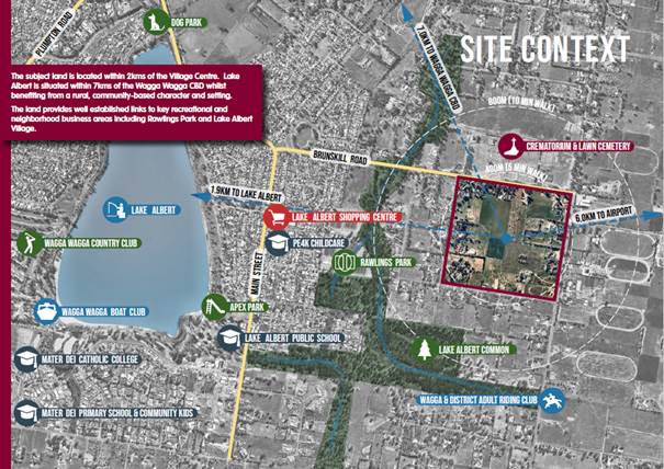
Figure 2 Site Context
The NSW Department of Planning, Industry and Environment issued a Gateway Determination for the planning proposal subject to public exhibition. A copy of the Gateway Determination is provided as attachment 3.
Public Exhibition
The planning proposal (attachment 1), Development Control Plan amendment (attachment 2) and accompanying exhibition material were placed on public exhibition from 9 January to 20 February 2021 (inclusive).
During the exhibition period, nine submissions were received. A summary of the key issues raised in the submissions and a response is provided under Internal / External Consultation section below.
Financial Implications
The application was lodged during the 2019/20 financial year and attracted an application fee of $40,000 in accordance with Council’s Fees and Charges Policy.
Council’s contributions plans will apply to any future development application on the land.
It is anticipated that the LEP and DCP amendments will result in new development on the subject land in the future. This has financial implications for Wagga Wagga City Council.
Section 7.11 of the Environmental Planning and Assessment Act 1979 and Council’s contributions plans enables Council to levy contributions, where anticipated development will or is likely to increase the demand for public facilities.
Section 64 of the Local Government Act 1993 Section 306 of the Water Management Act 2000 as well as Council’s development servicing plans enable Council to levy developer charges based on the increased demands that new development will have on sewer and/or stormwater.
The contribution and development servicing plans will apply to any future development on the land.
Policy and Legislation
Environmental Planning and Assessment Act 1979
Wagga Wagga Local Environmental Plan 2010
Link to Strategic Plan
The Environment
Objective: We plan for the growth of the city
Outcome: We have sustainable urban development
Risk Management Issues for Council
Council’s engineering team has reviewed the investigations and reports on infrastructure and in particular stormwater management for the proposal. Further detail will be required, if Council supports the recommendation, in regard to stormwater management to ensure the development does not amplify or create additional impacts.
Internal / External Consultation
|
|
|
Media |
Community Engagement |
Digital |
|||||||||||||
|
Rates notices insert |
Direct mail |
Letterbox drop |
Council news story |
Council News advert |
Media releases |
TV/radio advertising |
One-on-one meetings |
Your Say website |
Community meetings |
Stakeholder workshops |
Drop-in sessions |
Surveys and feedback forms |
Social media |
Email newsletters |
Website |
Digital advertising |
|
|
TIER |
|||||||||||||||||
|
Consult |
|
x |
|
x |
|
|
x |
|
|
|
x |
x |
|
||||
The planning proposal and accompanying exhibition material were made available for viewing by the public on Council’s website and at Council’s Customer Service Counter in the Civic Centre between 9 January and 20 February 2021. Notices were provided to affected and adjoining landowners.
During the public exhibition period, nine submissions were received. The submissions are provided as Attachment 4.
A summary of the submissions and Council Officer response is provided below:
|
Submission |
Officer Response |
|
|
No. 1 |
i. The Civil Aviation Safety Authority (CASA) does not raise any objections to the proposal as the site is located approximately 5km from the Wagga Wagga airport.
|
Noted. |
|
No. 2 |
i. Do not support the proposal.
ii. Little or no research has gone into the effects and impact of the increases in stormwater from the proposed subdivision on the Crooked Creek corridor during flooding events and therefore increased storm water flood flows into Sycamore Drain and beyond.
iii. The proposal does not take into account the neglected state of drainage infrastructure downstream.
iv. From experience we are very concerned that any additional stormwater will completely overwhelm this already overloaded and under maintained drainage system during flood events.
v. Until Sycamore Drain and its associated arms are completely cleared of trees, rubbish, illegal crossings and is de-silted and upgraded for the additional flows now and for future subdivisions we cannot support the proposed change under any circumstances.
|
Noted.
An infrastructure servicing report was prepared by Lance Ryan Consulting Engineers Pty Ltd and included as Appendix A3 of the Planning Proposal.
The purpose of that report was to investigate existing infrastructure and determine its adequacy to service further residential subdivision of land bound by Brunskill, Mitchell, Silverwood and Birch Roads.
The infrastructure report recommends that stormwater runoff be maintained to pre-development flows via table drains (vegetated and bioretention swales) and a stormwater retention basin.
In addition, it was recommended that stormwater is captured and collected on-site and for those few properties that don’t fall naturally toward the road include rear of lot underground pipes that discharge into the stormwater system.
The infrastructure report outlined in item (ii.) above investigated existing infrastructure and local conditions. Council’s engineers have further reviewed this report and provided their conditional approval to the planning proposal.
The infrastructure report outlined in item (ii.) above investigated existing infrastructure and local conditions. As outlined above, any future subdivision of this land will be required to achieve pre-development flows.
Concerns are noted. The Sycamore Drain is an earth channel on private property constructed as part of the subdivision of land north of Brunkills Road in 1980 to re-align Crooked Creek. Whilst Council is a beneficiary to a 20m wide easement over the channel to be able to drain water, Council has no liability to maintain the drain as part of the conveyancing S88B Instrument.
|
|
No. 3 |
i. Do not support the proposal.
ii. Little or no research has gone into the effects and impact of the increases in stormwater from the proposed subdivision on the Crooked Creek corridor during flooding events and therefore increased storm water flood flows into Sycamore Drain and beyond.
iii. The proposal does not take into account the neglected state of drainage infrastructure downstream.
iv. From experience we are very concerned that any additional stormwater will completely overwhelm this already overloaded and under maintained drainage system during flood events.
v. Until Sycamore Drain and its associated arms are completely cleared of trees, rubbish, illegal crossings and is de-silted and upgraded for the additional flows now and for future subdivisions we cannot support the proposed change under any circumstances.
|
Noted.
See response to item (ii.) of Submission No. 2 above.
See response to item (iii.) of Submission No. 2 above.
See response to item (iv.) of Submission No. 2 above.
See response to item (v.) of Submission No. 2 above.
|
|
No. 4 |
i. Do not support the proposal.
ii. Little or no research has gone into the effects and impact of the increases in stormwater from the proposed subdivision on the Crooked Creek corridor during flooding events and therefore increased storm water flood flows into Sycamore Drain and beyond.
iii. The proposal does not take into account the neglected state of drainage infrastructure downstream.
iv. From experience we are very concerned that any additional stormwater will completely overwhelm this already overloaded and under maintained drainage system during flood events.
v. Until Sycamore Drain and its associated arms are completely cleared of trees, rubbish, illegal crossings and is de-silted and upgraded for the additional flows now and for future subdivisions we cannot support the proposed change under any circumstances.
|
Noted.
See response to item (ii.) of Submission No. 2 above.
See response to item (iii.) of Submission No. 2 above.
See response to item (iv.) of Submission No. 2 above.
See response to item (v.) of Submission No. 2 above.
|
|
No. 5 |
i. Do not support the proposal.
ii. Concerned with localised flooding having experienced flooding on property in 2010 and 2012. This flood event resulted in floodwaters inside residential dwellings.
iii. Little or no research has gone into the effects and impact of the increases in stormwater from the proposed subdivision on the Crooked Creek corridor during flooding events and therefore increased storm water flood flows into Sycamore Drain and beyond.
iv. The proposal does not take into account the neglected state of drainage infrastructure downstream.
v. From experience we are very concerned that any additional stormwater will completely overwhelm this already overloaded and under maintained drainage system during flood events.
vi. Until Sycamore Drain and its associated arms are completely cleared of trees, rubbish, illegal crossings and is de-silted and upgraded for the additional flows now and for future subdivisions we cannot support the proposed change under any circumstances.
vii. We bought in the area for the open space around us. The number/size of lots proposed is too many and will take away the feel of open space, not to mention the extra stormwater.
|
Noted.
Noted. This area is part of the Crooked Creek flow path following significant storms. Flood modelling indicates that storm water up to 1m deep for a 1% AEP event may be experienced downstream of Brunkills Road outside of the Sycamore Drain.
See response to item (ii.) of Submission No. 2 above.
See response to item (iii.) of Submission No. 2 above.
See response to item (iv.) of Submission No. 2 above.
See response to item (v.) of Submission No. 2 above.
The range in lot sizes and proposed development controls will not significantly impact the existing character of the area.
|
|
No. 6 |
i. Opposed to this proposal as there is a history of council not maintaining the stormwater drains around our area, hence with additional housing located up stream will greatly impact the function of this, and ultimately cause infrastructure damage to properties.
ii. Concerned with localised flooding having experienced flooding on property in 2010, 2012 and 2016. This flood event resulted in floodwaters inside residential dwellings.
iii. The adjoining canals have been renamed as Marshalls Creek. This has affected us financially as a result from the floods in 2010 and the renaming of this drainage system, has resulted in my home insurance more than doubling.
iv. The council has not maintained, enhanced or made provisions for the existing infrastructure of this drainage system established prior to 1982.
v. I am strongly opposed to this proposal as I believe that not only will my house be flooded once again and I am financially impacted as a result.
|
Matters regarding Council maintenance are noted.
Whilst it is acknowledged that the development seeks to achieve more intensive development opportunities for this area, any further subdivision of this land will need to maintain pre-development flows, thereby minimising any impacts on the wider catchment.
See response to item (ii.) of Submission No. 5 above.
Noted. Matters regarding home insurance whilst acknowledged are not a relevant matter for consideration when making a planning decision.
See response to item (iii.) of Submission No. 2 above.
See response to item (ii.) of Submission No. 5 above.
|
|
No. 7 |
i. Object to the proposal.
ii. This proposal will introduce a lot more stormwater runoff into the already overloaded and poorly maintained Sycamore Drain. Houses in Sycamore Road have already been flooded on at least 3 occasions that we know of due to Council's unwillingness or lack of ability to properly maintain the Sycamore drain and the drainage system/retention basin in Rawlings Park which feeds into the Sycamore drain.
iii. The majority of the drainage channels in Rawlings Park are overgrown with vegetation and littered with fallen timber. We have lived in Sycamore Road for more than 30 years and in this time Council have only done work in the Sycamore Drain on one occasion.
iv. Request that Council carry out its maintenance before approving this proposal which will only exacerbate the overland flooding problem that is being experienced.
|
Noted.
Whilst it is acknowledged that the development seeks to achieve more intensive development opportunities for this area, any further subdivision of this land will need to maintain pre-development flows, thereby minimising any impacts on the wider catchment. An infrastructure report has been prepared and submitted as part of the planning proposal confirming that matters regarding stormwater management can be appropriately addressed.
Noted. This is a separate matter that is outside of the scope of the planning proposal.
Noted. See response to item (iii.) of Submission No. 2 above.
Any further subdivision of this land will need to maintain pre-development flows, thereby minimising any impacts on the wider catchment.
|
|
No. 8 |
i. Concerned about the amount of new residential blocks being created as we were not aware of the 150 to 180 new lots which potentially could see an increase of 600 to 700 people in what we thought was a large lot residential area which would conflict with the semi rural lifestyle we have.
ii. This raises other concerns with increased pedestrian access across Angle Street bridge an area which of late we as adjoining landowners have been maintaining. The reason of concern is loitering at the bridge which is very dark area at night also with an increase of rubbish etc in this corridor.
iii. Concerned about stormwater runoff from the new subdivision where and how will this enter Crooked Creek as rain water off hard surfaces and watered grounds (Lawns and gardens) may cause a surge or sudden increase to this area.
iv. Telecommunications has been an ongoing problem in the past for us as we are told because of our distance from the exchange, with the added dwellings will this impact.
|
Concerns regarding the number of residential lots sought by the planning proposal (150-180) are noted, however any landowner has the ability to request Council to consider a change in zoning and minimum lot size controls as they apply to their land.
In response, the planning proposal and concept subdivision layout/framework plan has been designed to minimise conflicts with adjoining land uses.
Specifically, an Urban Design Report was prepared in support of the planning proposal, which identified the semi-rural character of the area.
As a means of retaining this character and minimising conflicts with adjoining uses, the majority of infill development will be located internally within the site and will be largely screened from view via the existing dwellings.
Similarly, the number of new road access points will be restricted and the development will make provision for its own open space areas and walking tracks.
Matters regarding increased pedestrian activity, particularly those utilising the Angle Street bridge, will be further considered as development occurs to ensure pedestrian connectivity is adequate.
Ongoing maintenance of infrastructure, including pedestrian paths forms part of Council’s ongoing management planning.
See response to item (iv.) of Submission No. 2 above.
An infrastructure servicing report was prepared by Lance Ryan Consulting Engineers Pty Ltd and included as Appendix A3 of the Planning Proposal.
The purpose of this report was to investigate existing infrastructure (including telecommunications) and determine its adequacy to service further residential subdivision of the land.
NBN have confirmed that the development site is located within its fixed line footprint and that the development site can be appropriately serviced from a telecommunications perspective.
|
|
No. 8 |
i. Our foremost concern is infrastructure capacity to deal with stormwater runoff from this proposal.
ii. The infrastructure report provided as part of the proposal makes several statements and assertions about the likely effect of the development on stormwater flows and discharges. Most of this commentary revolves around controlling and retaining stormwater flows to pre-development flow levels and rates.
There is no data provided by the infrastructure report as to current or future likely stormwater flows that support the assertions made in the report.
iii. A stormwater or hydrology study to determine the impact of the development on stormwater flows in the creek has not been carried out.
iv. In the absence of expert evidence or assessment I am of the opinion that Council is making a decision on this proposal without sufficient probity and due diligence as to the likely effects of the inflows from the development on the overland flood flow and resultant afflux from the development’s stormwater discharge. This lack of valid assessment of stormwater impacts may result in increased flooding levels experienced by residents upstream of the discharge point for the development.
|
Noted.
The infrastructure servicing report has been prepared in consultation with Council’s development engineers.
Council engineers have advised that a stormwater study would need to be carried out to determine the size and depth of the proposed retention basin to minimise overland flooding impacts into the nearby creek.
This further information will be submitted as part of any subsequent development application for the subdivision of this land once the final subdivision design and layout has been determined.
Council has reviewed the infrastructure servicing report submitted as part of the planning proposal and concurred with the conclusions of this report.
Whilst it is acknowledged that a detailed hydrological study has not been completed as part of the planning proposal, Council have notified the proponent that if supported and endorsed, this information must be submitted as part of any subsequent development application for the subdivision of this land.
See response to item (ii.) of Submission No. 2 above.
Council has reviewed the information available in conjunction with recent overland flow studies and concluded the proposal is suitable and appropriate.
Further detail will be required on precise design, staging and construction of management systems. This will ensure adequate capacity and design is provided to meet forecast outcomes. In the absence of this detail the development will not proceed.
|
|
1. |
LEP19/0010 - Addendum and Planning Proposal - Provided under separate cover |
|
|
2. |
LEP19/0010 - Accompanying DCP Amendment - Provided under separate cover |
|
|
3. |
LEP19/0010 - Gateway Determination - Provided under separate cover |
|
|
4. |
LEP19/0010 - Submissions - Provided under separate cover |
|
|
5. |
LEP19/0010 - Landowner Details This matter is considered to be confidential under Section 10A(2) of the Local Government Act 1993, as it deals with: personnel matters concerning particular individuals. - Provided under separate cover |
|
|
Report submitted to the Ordinary Meeting of Council on Monday 22 March 2021 |
RP-4 |
RP-4 Planning Proposal - LEP20/0010 - Amend Wagga Wagga Local Environmental Plan Height of Building Control at 63-65 Johnston Street, Wagga Wagga
Author: Adam Wood
Director: Michael Keys
|
Summary: |
Council is in receipt of Planning Proposal LEP20/0010 to amend the Wagga Wagga Local Environmental Plan. The Planning Proposal means to increase the Height of Buildings Map as it applies to Lot 1 DP 1028542 at 63-65 Johnston Street. This would allow new or refitted buildings up to 25 metres tall, as opposed to the current 16 metres limit. The planning proposal has been assessed and has been found consistent with the planning provided for the city by Council and regional and state planning policies and strategies. Planning Proposal LEP20/0010 is recommended for endorsement to proceed to Gateway Determination by the Department of Planning, Industry and Environment. |
|
That Council: a note and support Planning Proposal LEP20/0010 to amend the Wagga Wagga Local Environmental Plan as it applies to Lot 1 DP 1028542. b submit Planning Proposal LEP20/0010 to the NSW Department of Planning, Industry and Environment and request a Gateway Determination. c receive a further report after the public exhibition period addressing any submissions made in respect of the planning proposal. |
|
Applicant: |
This is an externally-initiated planning proposal developed by the land owner. |
|
Land Owner: |
Wollundry Investments Pty Ltd. Director: Rodney Kendall Director: Robert Davies |
Council staff have conducted assessment of a planning proposal submitted by Wollundry Investments Pty Ltd. The planning proposal intends to increase the LEP Height of Buildings Map HOB_003C as it affects Lot 1 DP 1028542. The increase proposed is from the present 16 metre height limit to a new 25 metre height limit. The change to Wagga Wagga LEP Map HOB_003C is illustrated as follows.
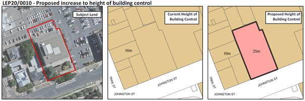
The subject land is located within the northern portion of the Wagga Wagga CBD, overlooking the Wollundry Lagoon from the northern, opposing side of Johnston Street. This location is approximately 120 metres from Fitzmaurice Street, the northern part of the main street of Wagga Wagga. Occupying a centrally located position within the city, the subject land is nearby to various keys locations and amenities and already embedded within the established infrastructural networks of the city.
The objective of the planning proposal is limited in its extent. The planning proposal proposes only the step increase to allowable building height as detailed above. No change to other provisions including zoning and floor space ratio are proposed. As a result, the interaction of the proposed height limit with these other continuing provisions has formed a key consideration in the assessment of the planning proposal.
Key considerations
1. Strategic significance of the Wagga Wagga CBD
Council has recently endorsed the Wagga Wagga Local Strategic Planning Statement. This document provides a pathway to guide the continued growth and development of the city and local government area through to 2040. The Wagga Wagga CBD is one of six key sites to provide the foundation for the future economic activity and growth of the city and region.
Principle 9 of the LSPS details aspirations for the future success of the Wagga Wagga CBD area. This section includes discussion and guidance concerning key aspects to accomplishing this success. In this instance, urban design and activation are both central to the merit of the planning proposal
The planning proposal adheres to the LSPS’ direction for the Wagga Wagga CBD, by enabling the development of additional floorspace. This facilitates the placement of additional activities within the confines of the CBD, in close proximity to the variety of other activities occurring in the central city. This aggregation of activities of various kinds, occurring at various times of the day, boosts the overall level of activity occurring within the city. The LSPS specifically calls for the use of higher buildings as a component of the urban design response to accomplish this. Planning Proposal LEP20/0010 specifically responds to this direction, by elevating development potential within the B3 Commercial Core zone and will increase the contribution of the subject land to overall activity levels within the city.
2. Future development potential within precinct and planning contexts
The increase of an additional 9 metres in permissible building height implies future development of two additional storeys to the existing four storeys. The provisions applying to the site would also continue to permit the complete redevelopment of the site. This would likely result in a new structure of up to 6 storeys, designed in accordance with contemporary DCP requirements and the State Environmental Planning Policy No 65 – Design Quality of Residential Apartment Development.
As outlined in the earlier part of this report, the planning proposal seeks to amend only the Height of Building Map applying to Lot 1 DP 1028542. A key part of the suitability of the planning proposal is the compatibility of the new building height control with the continuing provisions applying to the site and with pre-existing development within the local precinct. Key amongst these provisions is the floor space ratio, which is presently 2:1 across the subject land. Investigation of the subject land and existing and future development in relation to is detailed in the attached assessment report.
The assessment report finds that development up to the new height limit, within the existing building footprint only, would approximate the maximum floor space allowable under the current floor space ratio. Therefore, the new height limit appears well calibrated on this measure, as it allows the existing floor space ratio, to be properly exploited. If the site were redeveloped with a larger footprint, the upper floors of that structure would need to be slimmer than present to remain within the confines of the floor space ratio requirement.
Assessment of the planning proposal has also explored the impact of additional building height on the adjoining area and view scapes. Shadow casting from the existing development principally affects commercial sites located at 67 and 69 Johnston Street (southwest of the existing Wollundry Chambers building) during the morning hours. If this building is extended vertically, this shadow casting would extend further across these buildings.
While the increase to building height will be visible from the surrounds, the affect is incremental to development already existing in situ. To the east and south, commercial buildings and tree canopy associated with Wollundry Lagoon largely obscure the subject site until the viewer is nearby to the site. From the west, additional height will be more readily visible. Despite this, the subject site is setback into the subject city block from Trail Street to the west, which reduces the imposition of taller development upon streetscapes to the west.
The B3 Commercial Core zone currently permits shop-top housing where residences may be located above ground floor commercial floorspace. Further, Council intends to develop a CBD Master Plan. It is conceivable that this will further open opportunities for additional residential development in high density, inner city contexts. Further, the serviced apartment development foreshadowed by the planning proposal is not entirely dissimilar to development for other, more permanent lodgings. The assessment report provides commentary against the SEPP 65 Principles for higher density residential design. It finds that the new height limit provides the opportunity for future development to perform well against the design principles and deliver high-quality development outcomes to the site.
3. Heritage considerations
The site is within the Wagga Wagga Heritage Conservation Area, but the significance of urban features in the immediate area varies. The subject site itself does not greatly contribute to heritage values in the city. It is however visible from some parts of two significant locations for the city’s heritage, those being Fitzmaurice Street and the Wollundry Lagoon, an Aboriginal Place.
The subject land and surrounds to the north of Wollundry Lagoon have already been extensively developed. To date this has not diminished the significance of the Wollundry Lagoon, which will remain a key location both as an Aboriginal Place and as a public space within Central Wagga Wagga. Future redevelopment will not alter this significance. This will be further ensured through consideration of this point as a part of any development approval process that arises in future.
Fitzmaurice Street is the heritage main street of the city. A direct view line to the subject land can be achieved from the junction of Fitzmaurice Street and Johnston Street. This sightline to the existing development on site is mostly blocked by the office building to the east of the subject land. A future complete redevelopment of the site placing structures nearer to the frontage of Johnston Street would be more apparent from the Fitzmaurice-Johnston intersection, but this would be the case irrespective of any change to the LEP. In the event that this occurs, Council has sufficient ability through the guidance of the Wagga Wagga DCP, SEPP 65 and merit assessment to ensure that a suitable design outcome is obtained.
The site is obscured from Fitzmaurice Street by varied two and three storey development along the main street. Viewed from the Fitzmaurice Street bridge spanning the Wollundry Lagoon, the site and existing development are also heavily, though not entirely, obscured by canopy foliage associated with the Wollundry Lagoon parklands.
Financial Implications
The planning proposal has originated externally to the organisation. The planning proposal was identified as a medium complexity amendment to the Wagga Wagga Local Environmental Plan 2010 using the FY2020/21 grading schema in effect at the time of submission. Council has levied planning proposal fees totalling $16,000, as per Council’s fees and charges.
The planning proposal provides for the intensification of development on the subject land with additional building storeys and floor space. This may be achieved through additional development on the site, improvement to the existing development or complete redevelopment of the site. This has financial implications for Council into the future.
Section 7.11 of the Environmental Planning and Assessment Act 1979 and the City of Wagga Wagga’s Section 94 Contributions Plan 2006-2019 enables Council to levy contributions, where anticipated development will or is likely to increase the demand for public facilities. Section 64 of the Local Government Act 1993, Section 306 of the Water Management Act 2000 as well as the City of Wagga Wagga’s Development Servicing Plan for Stormwater 2007 and/or City of Wagga Wagga Development Servicing Plan for Sewerage 2013 enable Council to levy developer charges based on the increased demands that new development will have on sewer and/or stormwater infrastructure. The Section 7.11 and Section 64 contribution applies to any future development consent on the land. This will be applicable to future Development Applications applying to the subject land.
Policy and Legislation
Environmental Planning and Assessment Act 1979
Wagga Wagga Local Environmental Plan 2010
Link to Strategic Plan
The Environment
Objective: We plan for the growth of the city
Outcome: We have sustainable urban development
Risk Management Issues for Council
An approval of the proposal may be subject to public scrutiny during the formal public consultation process. This may result in additional pressure on Council to amend the Wagga Wagga LEP is it applies to other lands.
The planning proposal has been assessed to be consistent with the intent of the Wagga Wagga Local Strategic Planning Statement as it applies to the Wagga Wagga CBD. A refusal of the planning proposal would likely meet with pre-Gateway review by the NSW Department of Planning, Industry and Environment and may lead to questioning of Council’s commitment to implementing previously endorsed strategic directions and overall community confidence in Council’s endorsed strategic documents.
Internal / External Consultation
The planning proposal has been the subject of internal consultation in regard to its effect and implications. The planning proposal is supported in principle.
A Councillor workshop was held on March 15, 2021.
Formal public consultation with the general public and referral agencies will occur after the Gateway Determination. This will consist of a six week public exhibition and submission period. An engagement plan is attached detailing the intended engagement method.
Proposed consultation methods are indicated in the table below.
|
|
|
Media |
Community Engagement |
Digital |
|||||||||||||
|
Rates notices insert |
Direct mail |
Letterbox drop |
Council news story |
Council News advert |
Media releases |
TV/radio advertising |
One-on-one meetings |
Your Say website |
Community meetings |
Stakeholder workshops |
Drop-in sessions |
Surveys and feedback forms |
Social media |
Email newsletters |
Website |
Digital advertising |
|
|
TIER |
|||||||||||||||||
|
Consult |
|
ü |
|
ü |
|
|
ü |
|
|
|
|
ü |
|
||||
|
Involve |
|
|
|
|
|
|
|
|
|||||||||
|
Collaborate |
|
|
|
|
|
|
|
|
|
|
|
|
|
|
|
|
|
|
1. |
Planning Proposal LEP20-0010 - Provided under separate cover |
|
|
2. |
LEP20-0010 - Assessment Report - Provided under separate cover |
|
|
3. |
LEP20-0010 - Engagement Plan - Provided under separate cover |
|
|
Report submitted to the Ordinary Meeting of Council on Monday 22 March 2021 |
RP-5 |
RP-5 Friday night shopping and footpath activation trial
Author: Dominic Kennedy
Director: Michael Keys
|
Summary: |
Council resolved to support a program partnering with local businesses to promote Friday night shopping in December 2020. This report presents the outcomes and summary of key findings from the trial for Council’s information. The trial, projects undertaken, and surveys collected have delivered valuable insights into how the community are utilising the CBD and will guide future projects. |
|
That council receive and note the findings of this report |
Report
Background
A trial of Friday night shopping and increased footpath utilisation was endorsed at the 23 November 2020 Ordinary Council meeting. The suggestion was presented to Council staff during a November Business Roundtable meeting. The trial was held across three Friday nights in December (4th, 11th and 18th) and extended the full length of the main street.
The two main goals for the trial were to determine whether:
· Friday will attract more people than Thursday for late night shopping
· Footpath utilisation can be more broadly adopted to create vibrancy along the main street
It was anticipated that if these two goals were achieved, foot traffic on the main street and subsequently economic activity in the CBD would increase.
Trial results
Awareness was an issue on the first Friday – 4th of December. With less than two weeks to prepare, businesses struggled to plan and get organised. It was also the hottest of the three afternoons/evenings. However, during the subsequent two Fridays, attendance and interest was up. The trial was probably not long enough and was most likely impacted by other activities like Christmas parties or other private social events.
New visitation to the main street appears to have been driven by Santa on the fire truck, as opposed to the footpath utilisation and Friday night shopping element. There were noticeably more young families present and the extra week to prepare was used to generate awareness.
In general, businesses were supportive but many of them were exhausted from a tough year and felt staying open later on an additional night was difficult to manage. There were people around on the second week who wanted to shop but there really wasn’t that many places open. Not many new businesses (i.e. those who weren’t doing it before) took advantage of the footpath utilisation exemption.
Financial impacts
Council has access to transaction data to any Commonwealth Bank EFTPOS terminals and customers using CBA cards (data available to Council due to CBA being Council’s main trading bank). A report was generated that compared average daily sales in December 2019 and Nov-Dec 2020. It is important to note that this data reflects the entire LGA and not just the CBD.
While average daily sales (+2.57%) and the volume of daily transactions (+14.6%) increased, transaction size decreased (-10.5%). It is believed that the primary reason for the drop in transaction size is due to many people going cashless for all transactions, even those under $10. This will lead to a larger number of smaller transactions being processed.
Another observation from the report is that although there was a significant drop nationally (-2.76%), the local drop in average daily sales per customer was minor for the Wagga Wagga LGA (-0.18%).
Other observations around sales and transactions per age group show interesting COVID-related shifts such as transaction volumes for 15-34 year old people dropped, but increased for those aged over 35.
Business feedback
The Wagga Wagga Business Chamber (WWBC) received a variety of anecdotal feedback over the course of the three weeks with many of the responses stating that it was quiet. The second week of the trial was the biggest by far. There were young children all down the street with their families. This was probably because of how much extra advertising was done on social media. The WWBC also had a radio spot with a jingle their members created and promoted which started in the second week. They shared posts with a number of Facebook groups as well targeting young families at preschools and day cares. There needed to be something of interest to draw people down and Santa on a fire truck seemed to work. An interesting observation from a busker who started playing on Baylis Street at noon was that after 3:00 pm the foot traffic dropped significantly.
This trial was held at the same time that Council was implementing a Places to Love NSW grant project. Two main street events were initially planned as part of this grant, however this was changed due to COVID and instead included activations along the main street. These activations began in November and are still underway. They include: murals, alleyway upgrades, movable pump track, and the shipping container product displays which were installed in early December and removed by January.
A requirement of the grant has been for Council staff to engage businesses along the CBD in surveys to understand the effectiveness of the activations. The mural at Tompson Street depicting a yellow rosella has received the most attention and praise by business and the community, while the pump track has also been well utilised.
Surveys provided some of the following insights:
· What makes the space special or unique?
o River, levee, variety, mural
· What improvements could be made?
o Shade, lighting (decorative), footpaths, parking, seating, events
· Getting to the location and playing/participating was rated as easy
· Responses to questions related to features of the CBD that encouraged people to stay for longer periods of time indicated there were a lot of improvements that could be made.
· Responses to questions related to if the CBD was an area that fosters connections with other people and places also indicated there were a lot of improvements that could be made.
Conclusions
· Due to COVID-19, the trial may not be a true reflection of Friday night shopping and its demand in Wagga Wagga.
· Friday night shopping alone doesn’t appear to be enough to attract people to the main street – it is unclear if Friday night shopping were to be a permanent fixture, whether or not it would become more popular over time.
· The main street is very long (almost 2 km) with two distinct precincts, therefore initiatives should be customised for each precinct and not a one-size-fits-all approach (note: separate committees are being established for Baylis and Fitzmaurice Streets to develop and implement initiatives unique to their area).
· Although this idea came from the business community, there’s a need for a more coordinated response by Council, business and community groups on the implementation of similar initiatives in the future.
· Good clear data is needed in order to fully understand the impacts of these projects – data collection technology in key locations should be a consideration of a future smart city strategy.
Financial Implications
N/A
Policy and Legislation
Wagga Wagga City Council - Activities on Footpath policy (POL 041)
NSW and Commonwealth Government COVID Safe polices
Link to Strategic Plan
Growing Economy
Objective: We are a hub for activity
Outcome: We have vibrant precincts
Risk Management Issues for Council
N/A
Internal / External Consultation
This project was conducted in collaboration with the Business Roundtable group. Extensive support and resources were supplied by the Wagga Wagga Business Chamber and the Central Activity District committee business members.
Internal consultation was also conducted with Council’s Regulatory Services, along with delivery and support provided by Council’s Visitor Economy team for the mural and Places to Love activations.
|
|
|
Media |
Community Engagement |
Digital |
|||||||||||||
|
Rates notices insert |
Direct mail |
Letterbox drop |
Council news story |
Council News advert |
Media releases |
TV/radio advertising |
One-on-one meetings |
Your Say website |
Community meetings |
Stakeholder workshops |
Drop-in sessions |
Surveys and feedback forms |
Social media |
Email newsletters |
Website |
Digital advertising |
|
|
TIER |
|||||||||||||||||
|
Consult |
|
|
|
|
|
x |
|
|
|
|
x |
|
|||||
|
Involve |
|
|
|
x |
|
|
|
|
|
x |
x |
||||||
|
Collaborate |
|
|
|
|
|
|
|
|
|
|
|
|
|
|
|
|
|
|
Report submitted to the Ordinary Meeting of Council on Monday 22 March 2021 |
RP-6 |
RP-6 DRAFT Wagga Wagga Major Overland Flow Floodplain Study (MOFFS) & The Tarcutta, Ladysmith and Uranquinty Floodplain Study (VOFFS)
Author: Darren Raeck
|
Summary: |
This report recommends that Council receive the draft Wagga Wagga Major Overland Flow Floodplain Risk Management Study and Plan (MOFFS) completed by WMAWater and the draft Village Floodplain Risk Management Studies and Plans (VOFFS) completed by GRC Hydro and place on public exhibition. |
|
That Council: a receive the draft Wagga Wagga Major Overland Flow Floodplain Risk Management (MOFFS) Study and Plan report and place on public exhibition for a period of 40 days from 26 March 2021 and 5 May 2021 and invite public submissions until this date b receive the draft Village Overland Flow Floodplain Risk Management (VOFFS) Studies and Plans report and place on public exhibition for a period of 40 days from 26 March 2021 and 5 May 2021 and invite public submissions until this date a receive a further report following the public exhibition and submission period: i addressing any submission made in respect of the proposed reports ii proposing adoption of the reports unless there are any recommended amendments deemed to be substantial and required a further public exhibition period |
Report
Wagga Wagga City Council (Council) has, with the financial support of the NSW Government via the Floodplain Risk Management Program, commissioned WMA Water to complete the draft Wagga Wagga Major Overland Flow Floodplain Risk management Study (MOFFS) and Plan, and GRC Hydro to undertake Village Overland Flow Floodplain Risk Management Study (VOFFS) and Plans for the townships of Tarcutta, Ladysmith and Uranquinty.
These studies comprise stages 3 to 4 in a five-stage process outlined in the NSW Government’s Floodplain Development Manual (FDM, 2005) (DIPNR, 2007).
The works completed to date are steps 1 to 4 outlined below:
1. Data collection – collection of all applicable data to be used for the ensuing stages of the studies;
2. Flood Study – a comprehensive technical investigation of flood behaviour that provides the main technical foundation for the development of a robust floodplain risk management plan;
3. Floodplain Risk Management Study (FRMS) – assess the impacts of floods on the existing and future community and allows the identification of management measures to treat flood risk;
4. Floodplain Risk Management Plan (FRMP) – outlines a range of measures, for future implementation, to manage existing, future and residual flood risk effectively and efficiently.
The final step in the process following Public Exhibition and adoption of the Final report by Council is:
5. Plan Implementation – once the management plan is adopted, an implementation strategy (devised in Stage 4) is followed to stage components dependent on funding availability.
1. The draft Wagga Wagga Major Overland Flow Floodplain Study (MOFFS)
The draft MOFFS was prepared by WMAwater on behalf of Wagga Wagga City Council (Council). The Study builds on flood modelling initially developed in the draft Wagga Wagga Major Overland Flow Flood Study (MOFFS) (August 2011), which has been part of this study based on recommendations of the draft Wagga Wagga Major Overland Flow Floodplain Risk Management Study - Scoping Study and outcomes of the Major Overland Flow Model Update Work undertaken in these studies has been expanded upon in this Floodplain Risk Management Study and Plan (FRMS&P) to further understand and determine the nature and extent of the overland flow flood risk at Wagga Wagga.
The Study comprised of two phases:
1. The draft Wagga Wagga Major Overland Flow Floodplain Risk Management Study; and
2. The Wagga Wagga Major Overland Flow Floodplain Risk Management Draft Plan.
The main objective of this FRMS&P was to develop flood risk mitigation strategies that addressed existing, future and continuing flood problems due to local catchment (not riverine) flooding in Wagga Wagga. The study was undertaken in accordance with the NSW Government's Flood Policy, as detailed in the “Floodplain Development Manual: the management of flood liable land”, New South Wales Government, April 2005.
Note that riverine flooding from the Murrumbidgee River is not assessed in this Study. For information on riverine flooding and mitigation measures please refer to the Wagga Wagga Revised Murrumbidgee River Floodplain Risk Management Study and Plan, (Reference 7), adopted by Council in March 2018.
The objective of the Floodplain Risk Management Study was to investigate a range of flood mitigation works and measures to address the existing, future and continuing flood problems, in accordance with the NSW Government's Flood Policy.
This includes:
· Update topography and the built environment to reflect current conditions; Assess the sensitivity of the existing flood model to Australian Rainfall and Runoff 2016 methodologies and update the flood model accordingly; Review Council’s existing environmental planning policies and instruments including Council’s long-term planning strategies for the study area; Identify works, measures and restrictions aimed at reducing the social, environmental and economic impacts of flooding and the losses caused by flooding on development and the community, both existing and future, over the full range of potential flood events and taking into account the potential impacts of climate change;
· To assess the effectiveness of these works and measures for reducing the effects of flooding on the community and development, both existing and future;
· To consider whether the proposed works and measures might produce adverse effects (environmental, social, economic, or flooding) in the floodplain and whether they can be minimised; Council has adopted / followed the recommendation outlined in the Department of Planning Circular PS 07-003 and “Guideline on Development Controls on Low Flood Risk Areas – Floodplain Development Manual, i.e.;
o Review the local flood plan, identify deficiencies in information and address the issues identified in the DECCW Guideline “SES Requirements from the FRM Process.”;
o Examination of the present flood warning system, community flood awareness and emergency response measures in the context of the NSW State Emergency Service's development and disaster planning requirements;
o Investigate options for Lake Albert;
o Identification of modifications required to current policies in the light of investigations.
Major Overland Flow Floodplain Risk Management Plan Objectives
The Major Overland Flow Floodplain Risk Management Plan makes a range of recommendations relating to flood mitigation works and measures that address the existing, future and continuing flood problems, in accordance with the NSW Government's Flood Prone Land Policy. The recommended works and measures presented in the Plan aim to:
· Reduce the flood hazard and risk to people and property in the existing community and to ensure future development is controlled in a manner consistent with the flood hazard and risk (taking into account the potential impacts of climate change).
· Reduce private and public losses due to flooding.
· Protect and where possible enhance the creek and floodplain environment.
· Be consistent with the objectives of relevant State policies, in particular, the Government’s Flood Prone Land and State Rivers and Estuaries Policies and satisfy the objectives and requirements of the Environmental Planning and Assessment Act, 1979.
· Ensure that the draft floodplain risk management plan is fully integrated with Council’s existing corporate, business and strategic plans, existing and proposed planning proposals, meets Council’s obligations under the Local Government Act, 1993 and has the support of the local community.
· Ensure actions arising out of the draft plan are sustainable in social, environmental, ecological and economic terms.
· Ensure that the draft floodplain risk management plan is fully integrated with the local emergency management plan (flood plan) and other relevant catchment management plans.
· Establish a program for implementation and suggest a mechanism for the funding of the plan and include priorities, staging, funding, responsibilities, constraints, and monitoring.
The area considered in the draft Wagga Wagga Major Overland Flow Floodplain Risk Management Study incorporates catchments with an area of 233 km2 and a hydraulic modelling extent of 167 km2 both south and north of the Murrumbidgee River. Within the overall extent are distinct areas with localised and independent flooding issues, and for this reason (and to manage model run times) the Study Area was been broken up into four domains, summarised in the table below:
Table 1 Study Areas
|
Domain |
Area |
Key Features |
|
City |
42 |
· Glenfield Drain, Wagga Wagga CBD and outer areas lying on the southern Murrumbidgee River floodplain. |
|
Lake Albert |
69 |
· Includes the upstream catchment of Lake Albert as well as the inflows to and outflows from Lake Albert; · Flow from Stringybark Creek (running from the south to the west of the lake) is directed into Lake Albert for all events less than approximately the 10% AEP event; and · Crooked Creek runs from the south and to the east of Lake Albert, and is also diverted into Lake Albert in frequent events. |
|
East |
26 |
· Marshall’s Creek and Gregadoo Creek · Eastern Industrial area |
|
Wagga North |
35 |
· Duke’s Creek from its headwaters to its confluence with the Murrumbidgee River (Gobbagombalin Lagoon). Includes inflows from Estella, Boorooma, and vacant land south of the Olympic Highway; · Note the suburb of North Wagga is located to the east of the Dukes Creek floodplain and is therefore not included in this modelling. |
Recommendations
This project commenced in 2018, but its completion was delayed by 12 months due to COVID-19. The main recommendations with a high priority from MOFFS are:
RM01 Amend Flood Plans to include Overland Flow Flood information
RM04 Community Flood Awareness
P01 Adoption of Overland Flow Flood Planning Area
P02 Adoption of Overland Flow Flood Planning Level
P05 Appropriate land Use Zoning in Future Development Areas
P07 Appropriate Management of areas subject to both Riverine and overland flood risk
P08 Confirm suitability of riverine flood related development controls within the overland flow PMF extent
P09 Inclusion of Overland Flow flood information on Section 10.7 Planning Certificates
GD02 Adjin Street & Maher Street Intersection Civil Works (further investigation)
GD03 Anderson Oval Basin and Swale Augmentation (further investigation)
GD05 Flowerdale Lagoon Drainage Improvements (Funding request commenced, closes 18 March 2021)
SW01 Incarnie Crescent Stormwater Line
LA01 Raising Lake Albert Road (Funding request commenced)
LA02 Augmentation of Crooked Creek Diversion into Lake Albert (Funding request commenced)
LA03 Augmentation of Stringybark Creek Diversion into Lake Albert (Funding request commenced)
2. The Village Floodplain Risk Management Overview
The draft VOFFS Report describes the data collection, model update, flood risk assessment and mitigation measures assessment of the Tarcutta, Ladysmith & Uranquinty Floodplain Risk Management Studies and Plans (FRMS&P). The study, which has been undertaken by GRC Hydro on behalf of Wagga Wagga City Council, follows on from the Tarcutta, Ladysmith and Uranquinty Flood Studies, completed in late 2014, which themselves were in response to the significant flood events of 2010 and 2012.
The FRMS&P investigates flood risk in the three towns, and will inform the Council flood planning processes, and recommend a number of flood risk mitigation measures in the Floodplain Risk Management Plan. The Plan is presented as a table in this executive summary. The report contains the following sections:
· Background – description of the three study areas, overview of relevant policies and legislation and available data.
· Overview of Flood Behaviour – methodology and results of Australian Rainfall and Runoff 2019 (ARR2019) model updates.
· Flood Risk Assessment – Separate section for each town including flood hazard, hydraulic categories, levee function, flooding hotspots, flood warning and emergency response
· Flood Risk Mitigation Measures – description of the approach to flood mitigation and assessment of options in each town.
· Community consultation undertaken during the project
Model Update Results
The current study has updated the modelling approach used in the flood study to be consistent with ARR2019, which has significantly affected design flood levels. The approach, which involves updates to the design rainfall, losses, temporal patterns and other model parameters, was confirmed with Council and DPIE after preliminary results that showed issues with the prescribed losses values. Losses were then updated in accordance with DPIE guidelines updated in early 2019.
The draft VOFFS report presents the updated flood behaviour for each town for the range of design events, which incorporates mainstream and overland flooding. The results show that areas of mainstream flooding are around 0.1 to 0.3 m higher than previously adopted, while overland flooding is largely unchanged. This corresponds to an increase in flood hazard and other post-processed model outputs.
Flood Risk Assessment
An assessment of each town’s flood behaviour has been carried out to determine specific areas of flood risk across a range of metrics, including flood hazard, hydraulic categories, the existing levees, the economic impact of flooding and the flood warning available. The risk assessment for each town is presented in Section 4 (Tarcutta), Section 5 (Ladysmith) and Section 6 (Uranquinty), with sections for each of the metrics.
In summary the risk assessment found that:
· Tarcutta has severe flood affectation in parts of the town, due to Tarcutta Creek flooding for floods of 5 % AEP and greater, when inundation occurs on Sydney Street and Centenary Avenue. Several properties are flooded above floor in such flood events and the main road (Sydney Street) is cut-off in the 20% AEP event. The existing levee is overtopped in approximately the 2% AEP event which causes high velocity flow into Centenary Avenue properties. The levee can also cause flooding when it’s cross-drainage structures either block overland flow draining to the creek, or allow creek flow into the town area. The majority of the town is not flooded by mainstream flooding and there is evacuation access for most flooded properties. There are two main overland flowpaths in the town that cause flooding of yards and roads. Refer to Figure A 5 for the location of these features.
· Ladysmith has minimal flood affectation due to flooding of Kyeamba Creek for events up to and including the 0.5% AEP, with the floodplain generally separate to the urban area. Above floor flooding due to mainstream flooding only occurs for the 0.2% and PMF event. There is no levee in the town. There are 3 overland flowpaths that cause flooding of yards and roads in frequent flood events (20% AEP and greater). Refer to Figure B 5 for the location of these features.
· Uranquinty is severely affected by Sandy Creek flooding for floods of 5% AEP and greater, when inundation occurs via overtopping of Deane Street via a breakout of Sandy Creek. To the north, an overland flowpath overtops the Connorton Street levee and floods many properties, with mostly below floor flooding. When local catchment flooding coincides with flooding of Sandy Creek (as it did in recent floods), the two flowpaths generally coincide to cause severe flooding of the southern portion of town and the western portion near Ryan and King Streets. The main levee section, which runs from the south end of Deane Street to Uranquinty Cross Road, is overtopped on several locations in the 0.2% AEP. The levee has a lower section close to Baker Street, where it already overtops in a 10% AEP event. There is generally evacuation access during flood events. Refer to Figure C 5 for the location of these features.
Flood Risk Mitigation Measures
A range of flood risk mitigation measures have been assessed for each town based on assessment of the flood risk, and consultation with Council and the community. The types of measures have been categorised as flood modification, property modification or response modification, in accordance with the NSW Floodplain Development Manual (DIPNR, 2007). Flood modification measures have focussed on upgrading the existing levee systems and their drainage, and various other measures. Where appropriate measures have been modelled using one or multiple design flood events. Property modification options include a Flood Planning Area for each town, and adapting measures recently proposed in the LGA by other FRMS&Ps. Response modification measures include improving the warning system for Tarcutta and Uranquinty, and increased flood awareness. A full list of assessed measures is set out in Section 8 of the draft VOFFS Report and the recommended measures are summarised below.
Recommendations
The main recommendations that are in the VOFFS report are:
RM01/ 4/ 6 Update the Wagga Wagga local Flood Plan section for each town
RM02/ 5/ 8 Update Flood Intelligence Cards for each town
UL01 Uranquinty Levee System Upgrade (Funding request commenced)
RM10 Community Flood Education
Financial Implications
The total project budgets, expenditure and commitments as at 17 March 2021 are as follows:
|
Total Project Budget |
Expended + Committed as at 17 March 2021 |
Budget Remaining/ (overspend) |
|
|
Wagga Wagga Major Overland Flow Flood (MOFF) Risk Management Study and Plan FM-0099 - (17826) |
$228,940 |
$232,994 |
($4,054) |
|
Wagga Wagga Villages Floodplain Risk Management Study and Plan FM-115 - (18640) |
$198,000 |
$141,872 |
$56,127 |
Policy and Legislation
N/A
Link to Strategic Plan
Community Leadership and Collaboration
Objective: We have strong leadership
Outcome: We plan long term
Risk Management Issues for Council
· Delay in placing the Plans on Public Exhibition may result in delays in commencement of the works.
· Environmental impacts due to extent of works required
· Increased risk of flooding.
· Reputational risk.
Internal / External Consultation
The draft documents have been the subject of internal consultation and have been endorsed by the Floodplain Risk Management Committee at it meeting on 23 February 2021 as outlined in M-1.
A Councillor workshop was held on March 15, 2021.
Whilst the required Public Exhibition period is 28 Days, it is recommended that the plans remain available for comment for a period of 40 days due to the size and complexity of the documents.
Proposed consultation methods are indicated in the table below.
|
|
|
Media |
Community Engagement |
Digital |
|||||||||||||
|
Rates notices insert |
Direct mail |
Letterbox drop |
Council news story |
Council News advert |
Media releases |
TV/radio advertising |
One-on-one meetings |
Your Say website |
Community meetings |
Stakeholder workshops |
Drop-in sessions |
Surveys and feedback forms |
Social media |
Email newsletters |
Website |
Digital advertising |
|
|
TIER |
|||||||||||||||||
|
Consult |
|
|
|
|
x |
|
x |
x |
x |
|
|
|
x |
x |
|||
|
Involve |
|
|
|
x |
|
|
x |
|
|
|
|||||||
|
Collaborate |
|
|
x |
x |
|
|
|
|
|
|
|
|
|
|
|
|
|
|
1. |
MOFFS - Wagga Wagga Major Overland Flow Floodplain Risk Management Study and Plan - Provided under separate cover |
|
|
|
2. |
MOFFS - Figures - Provided under separate cover |
|
|
|
3. |
MOFFS - Appendix - Provided under separate cover |
|
|
|
4. |
VOFFS - Main Report - Provided under separate cover |
|
|
|
5. |
VOFFS - Appendix - Provided under separate cover |
|
|
|
6. |
VOFFS – Appendix B - Provided under separate cover |
|
|
|
7. |
VOFFS – Appendix C - Provided under separate cover |
|
|
|
Report submitted to the Ordinary Meeting of Council on Monday 22 March 2021 |
RP-7 |
RP-7 FINANCIAL PERFORMANCE REPORT AS AT 28 FEBRUARY 2021
Author: Carolyn Rodney
Director: Natalie Te Pohe
|
Summary: |
This report is for Council to consider information presented on the 2020/21 budget and Long-Term Financial Plan, and details Council’s external investments and performance as at 28 February 2021. |
|
That Council: a approve the proposed 2020/21 budget variations for the month ended 28 February 2021 and note the continued forecast deficit budget position as a result of the COVID‑19 pandemic b approve the proposed budget variations to future financial years of the Long-Term Financial Plan c authorise the acceptance, preparation and execution of all documents under Council Seal as required to facilitate the undertaking of the approved projects by the respective user groups of the following 2020/21 Crown Reserves Improvement Fund Grants (all GST exclusive figures): i) Flowerdale Footbridge Silverlite $157K ii) Wagga Bidgee & District Pony Club Works $ 18K iii) Cabarita Park Facility Upgrade $ 27K iv) Collingullie Oval & Cross Roads Oval Works $ 16K d note the Responsible Accounting Officer’s reports, in accordance with the Local Government (General) Regulation 2005 (Part 9 Division 3: Clause 203) that the financial position of Council is satisfactory having regard to the original estimates of income and expenditure and the recommendations made above e note the details of the external investments as at 28 February 2021 in accordance with section 625 of the Local Government Act 1993 |
Report
Wagga Wagga City Council (Council) continues to forecast deficit budget positions as a result of the estimated financial impact the COVID-19 pandemic is having on many businesses, with local councils not immune to the pandemic.
At this stage, Council forecasts a $834K deficit budget position for the 2020/21 budget year (as at 28 February 2021). This will continue to be reviewed as the year progresses, with updates provided to Council as part of the monthly financial performance report.
Council has experienced a negative monthly investment performance for the month of February when compared to budget ($99,988 down on the monthly budget). This is mainly due to a decrease in the principal value of Council’s Floating Rate Note portfolio as at 28 February 2021.
Key Performance Indicators
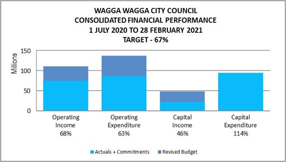
OPERATING INCOME
Total operating income is 68% of approved budget so is trending slightly over budget for the month of February 2021. An adjustment has been made to reflect the levy of rates that occurred at the start of the financial year. Excluding this adjustment, operating income received is 90% when compared to budget.
OPERATING EXPENSES
Total operating expenditure is 63% of approved budget and is tracking slightly under budget at this stage of the financial year.
CAPITAL INCOME
Total capital income is 46% of approved budget. It is important to note that the actual income from capital is influenced by the timing of the receipt of capital grants and contributions relating to projects. This income also includes the sale of property, plant and equipment.
CAPITAL EXPENDITURE
Total capital expenditure including commitments is 114% of approved budget which is as a result of the full contract amounts being raised for multi-year projects.
|
WAGGA WAGGA
CITY COUNCIL |
|||||||
|
CONSOLIDATED STATEMENT |
|||||||
|
|
ORIGINAL |
BUDGET ADJ |
APPROVED BUDGET |
YTD ACTUAL EXCL COMMT'S 2020/21 |
COMMT'S 2020/21 |
YTD ACTUAL + COMMT'S |
YTD % OF BUD |
|
Revenue |
|||||||
|
Rates & Annual Charges |
(72,529,470) |
0 |
(72,529,470) |
(48,340,732) |
0 |
(48,340,732) |
67% |
|
User Charges & Fees |
(22,261,420) |
0 |
(22,261,420) |
(15,097,782) |
0 |
(15,097,782) |
68% |
|
Interest & Investment Revenue |
(2,306,255) |
0 |
(2,306,255) |
(2,043,912) |
0 |
(2,043,912) |
89% |
|
Other Revenues |
(2,931,718) |
(1,450,879) |
(4,382,597) |
(2,992,651) |
0 |
(2,992,651) |
68% |
|
Operating Grants & Contributions |
(13,415,374) |
4,535,785 |
(8,879,589) |
(6,440,894) |
0 |
(6,440,894) |
73% |
|
Capital Grants & Contributions |
(89,541,725) |
44,511,962 |
(45,029,763) |
(19,985,266) |
0 |
(19,985,266) |
44% |
|
Total Revenue |
(202,985,962) |
47,596,868 |
(155,389,094) |
(94,901,236) |
0 |
(94,901,236) |
61% |
|
|
|||||||
|
Expenses
|
|||||||
|
Employee Benefits & On-Costs |
48,595,768 |
(494,102) |
48,101,666 |
29,216,377 |
0 |
29,216,377 |
61% |
|
Borrowing Costs |
3,452,579 |
(207,776) |
3,244,803 |
1,548,277 |
0 |
1,548,277 |
48% |
|
Materials & Contracts |
30,860,378 |
6,972,854 |
37,833,232 |
20,982,283 |
5,179,999 |
26,162,282 |
69% |
|
Depreciation & Amortisation |
35,177,865 |
0 |
35,177,865 |
23,451,910 |
0 |
23,451,910 |
67% |
|
Other Expenses |
9,985,219 |
2,385,791 |
12,371,010 |
5,758,171 |
105,391 |
5,863,562 |
47% |
|
Total Expenses |
128,071,808 |
8,656,767 |
136,728,576 |
80,957,018 |
5,285,391 |
86,242,409 |
63% |
|
|
|||||||
|
Net Operating (Profit)/Loss |
(74,914,154) |
56,253,635 |
(18,660,518) |
(13,944,218) |
5,285,391 |
(8,658,827) |
|
|
|
|||||||
|
Net Operating (Profit)/Loss before Capital Grants & Contributions |
14,627,571 |
11,741,673 |
26,369,244 |
6,041,048 |
5,285,391 |
11,326,439 |
|
|
|
|||||||
|
Capital / Reserve Movements |
|||||||
|
Capital Expenditure - One Off Confirmed |
31,423,131 |
25,586,437 |
57,009,568 |
21,040,150 |
60,305,762 |
81,345,913 |
143% |
|
22,666,954 |
(1,411,353) |
21,255,601 |
6,455,007 |
3,430,839 |
9,885,846 |
47% |
|
|
102,263,183 |
(102,263,184) |
0 |
32,901 |
0 |
32,901 |
0% |
|
|
Loan Repayments |
4,718,119 |
(307,774) |
4,410,344 |
2,940,230 |
0 |
2,940,230 |
67% |
|
New Loan Borrowings |
(22,723,947) |
11,842,113 |
(10,881,833) |
0 |
0 |
0 |
0% |
|
Sale of Assets |
(2,173,514) |
(1,018,634) |
(3,192,148) |
(2,105,635) |
0 |
(2,105,635) |
66% |
|
Net Movements Reserves |
(21,740,087) |
10,661,250 |
(11,078,837) |
0 |
0 |
0 |
0% |
|
Total Cap/Res Movements |
114,433,839 |
(56,911,145) |
57,522,695 |
28,362,652 |
63,736,602 |
92,099,254 |
|
|
|
|||||||
|
|
ORIGINAL |
BUDGET ADJ |
APPROVED
BUDGET |
YTD ACTUAL EXCL COMMT'S 2020/21 |
COMMT'S 2020/21 |
YTD ACTUAL +
COMMT'S |
YTD % OF BUD |
|
Net Result after Depreciation |
39,519,685 |
(657,509) |
38,862,177 |
14,418,435 |
69,021,992 |
83,440,427 |
|
|
|
|||||||
|
Add back Depreciation Expense |
35,177,865 |
0 |
35,177,865 |
23,451,910 |
0 |
23,451,910 |
67% |
|
|
|||||||
|
Cash Budget (Surplus) / Deficit |
4,341,820 |
(657,509) |
3,684,310 |
(9,033,475) |
69,021,992 |
59,988,517 |
|
|
Description |
Budget 2020/21 |
Budget 2021/22 |
Budget 2022/23 |
Budget 2023/24 |
Budget 2024/25 |
Budget 2025/26 |
Budget 2026/27 |
Budget 2027/28 |
Budget 2028/29 |
Budget 2029/30 |
|
Adopted Bottom Line (Surplus) / Deficit |
4,341,819 |
2,909,316 |
2,682,933 |
1,763,495 |
2,131,200 |
3,137,673 |
2,748,594 |
1,622,670 |
1,359,793 |
740,739 |
|
Prior Adopted Bottom Line Adjustments |
(657,509) |
(569,550) |
(759,410) |
(948,879) |
(1,158,789) |
(1,219,422) |
(1,464,291) |
(1,703,226) |
(1,958,832) |
(2,222,476) |
|
Revised Bottom Line (Surplus) / Deficit** |
3,684,310 |
2,339,766 |
1,923,523 |
814,616 |
972,411 |
1,918,251 |
1,284,303 |
(80,556) |
(599,039) |
(1,481,737) |
** Note that the Revised Bottom Line (Surplus) / Deficit shown does not include the proposed budget variations for February 2021 or any adjustments in the draft Long Term Financial Plan.
Categories for budget adjustments in this month’s finance report:
This month’s Budget adjustments are categorised as follows:
1. Budget Variations which affect the current 2020/21 financial year
2. Proposed adjustment to the Plant Sales and Purchases for the term of the LTFP
3. Proposed adjustments to future year budgets
1. The proposed Budget Variations for 28 February 2021 which affect the current 2020/21 financial year are listed below:
|
Budget Variation |
Amount |
Funding Source |
Net Impact (Fav)/ Unfav |
|||||||||||||||||||||||||||||||||||||||||||||||||||||||||||||||||||||||||||||||||||||||||||||||||
|
1 – Community Leadership and Collaboration |
||||||||||||||||||||||||||||||||||||||||||||||||||||||||||||||||||||||||||||||||||||||||||||||||||||
|
Lost Lanes |
$35K |
New Year’s Eve ($28K) Artstate 2020 ($7K) |
Nil |
|||||||||||||||||||||||||||||||||||||||||||||||||||||||||||||||||||||||||||||||||||||||||||||||||
|
Lost Lanes 2021 is scheduled for Saturday 26 June 2021 and will be reformatted to meet the public health orders around mass gatherings. The format for 2021 will include a larger footprint including locations in Baylis and Fitzmaurice Street laneways to ensure the event is being delivered in a COVID-19 safe way. It is proposed to fund the expenses from savings from the New Year’s Eve and Artstate 2020 Events. These funds will be used to cover the costs associated with cleaning and sanitisation, crowd management, fencing, COVID-19 marshalling and contact tracing. Estimated Completion: 30 June 2021 Job Consolidation: 19524 |
|
|||||||||||||||||||||||||||||||||||||||||||||||||||||||||||||||||||||||||||||||||||||||||||||||||||
|
Investment Income Airport Income Development Income Parks & Sportsgrounds Fees & Charges |
($450K) ($1,125K) ($1,071K) ($110K)
|
|
($2,755K) |
|||||||||||||||||||||||||||||||||||||||||||||||||||||||||||||||||||||||||||||||||||||||||||||||||
|
Council officers have undertaken a review of the previously estimated impact the COVID-19 pandemic has had on Council’s budgets and note the following:
- Investment income - $450K favourable investment income budget variation due to an improved result on revised budget along with a larger than anticipated investment portfolio balance
- Airport income - $3,027K reduced income estimated due to COVID-19, however the Airport has been functioning on a reduced scale, with some income being received year to date. Net of expenses, the Airport COVID‑19 estimated deficit is now $1,902K.
- Development income - $1,071K reduced income estimated due to COVID‑19, however the current building market has not seen a reduction in activity.
- Parks and Sportsgrounds fees and charges - $110K reduced income estimated due to COVID-19. Whilst it is still anticipated Council will receive reduced income for parks and sportsgrounds fees and charges, the parks area has savings in other expenditure budgets to date.
Job Numbers: 11600,47010,14300 & 25100 |
|
|||||||||||||||||||||||||||||||||||||||||||||||||||||||||||||||||||||||||||||||||||||||||||||||||||
|
ANZAC Day Celebrations |
$13K |
Major Events ($13K) |
Nil |
|||||||||||||||||||||||||||||||||||||||||||||||||||||||||||||||||||||||||||||||||||||||||||||||||
|
Funds are required to cover the costs relating to the delivery of a COVID‑19 safe ANZAC Day 2021 Ceremony event including fencing, COVID-19 marshalling, signage and sanitisation processes. It is proposed to fund this from available funds in the existing Major Events budget. Estimated Completion: 30 June 2021 Job Consolidation: 12107 |
|
|||||||||||||||||||||||||||||||||||||||||||||||||||||||||||||||||||||||||||||||||||||||||||||||||||
|
2 – Safe and Healthy Community |
||||||||||||||||||||||||||||||||||||||||||||||||||||||||||||||||||||||||||||||||||||||||||||||||||||
|
Flowerdale Footbridge |
$79K |
NSW State Government Grant ($79K) |
Nil |
|||||||||||||||||||||||||||||||||||||||||||||||||||||||||||||||||||||||||||||||||||||||||||||||||
|
Council has been successful in securing State Government grant funds under the Crown Reserves Improvement Fund for the renewal of the Flowerdale Footbridge which is located on the Wiradjuri Trail. The works consist of a footbridge upgrade and the upgrade of the Red Hill Road underpass located in the Silverlite Reserve with associated new fencing. The total project budget is $157,297 with works scheduled 50% in 2020/21 and 50% in 2021/22. Council staff will be project managing these works. Estimated Completion: 30 June 2022 Job Consolidation: 21285 |
|
|||||||||||||||||||||||||||||||||||||||||||||||||||||||||||||||||||||||||||||||||||||||||||||||||||
|
Wagga Bidgee & District Pony Club Works |
$18K |
NSW State Government Grant ($18K) |
Nil |
|||||||||||||||||||||||||||||||||||||||||||||||||||||||||||||||||||||||||||||||||||||||||||||||||
|
Council has been successful in securing State Government grant funds under the Crown Reserves Improvement Fund for the replacement and upgrade of the existing boundary fencing and removal of rubbish on a reserve utilised by the Wagga Bidgee and District Pony Club (Club). Council will transfer the $18K funds received from the NSW State Government to the Club for them to undertake the works, with an acquittal process at the completion of works. Estimated Completion: 30 June 2021 Job Consolidation: 21319 |
|
|||||||||||||||||||||||||||||||||||||||||||||||||||||||||||||||||||||||||||||||||||||||||||||||||||
|
Cabarita Park Facility Upgrade |
$27K |
NSW State Government Grant ($27K) |
Nil |
|||||||||||||||||||||||||||||||||||||||||||||||||||||||||||||||||||||||||||||||||||||||||||||||||
|
Council has been successful in securing State Government grant funds under the Crown Reserves Improvement Fund for the upgrade of the facility at Cabarita Park. The upgrade is to include the walls, roof, kitchen, bathroom and the erection of an awning. Council will transfer the $27K funds received from the NSW State Government to Wagga Swimming Club for them to undertake the works, with an acquittal process at the completion of works. Estimated Completion: 30 June 2021 Job Consolidation: 21317 |
|
|||||||||||||||||||||||||||||||||||||||||||||||||||||||||||||||||||||||||||||||||||||||||||||||||||
|
Collingullie Oval & Cross Roads Oval Works |
$16K |
NSW State Government Grant ($16K) |
Nil |
|||||||||||||||||||||||||||||||||||||||||||||||||||||||||||||||||||||||||||||||||||||||||||||||||
|
Council has been successful in securing State Government grant funds under the Crown Reserves Improvement Fund for the installation of a rainwater tank and pump system and improvements to access roads and car parks at the Collingullie Oval and Cross Roads Oval. Council will transfer the $16K funds received from the NSW State Government to Collingullie Glenfield Park Football and Netball Club Inc. for them to undertake the works, with an acquittal process at the completion of works. Estimated Completion: 30 June 2021 Job Consolidation: 21318 |
|
|||||||||||||||||||||||||||||||||||||||||||||||||||||||||||||||||||||||||||||||||||||||||||||||||||
|
3 – Growing Economy |
||||
|
CBD Masterplan |
$150K |
Rezoning/Planning Proposal Application Income ($68K) Economic Development Operational Budgets ($82K) |
Nil |
|
|
Estimated Completion: 30 June 2021 Job Consolidation: 20844 |
|
|||
|
Livestock Marketing Centre Income |
$500K |
LMC Salary Savings ($100K) LMC Reserve ($400K) |
Nil |
|
|
The Livestock Marketing Centre (LMC) has experienced an annual reduction in income of $500K for two years. This can be attributed to the drought years affecting the overall breeding numbers of cattle and will impact on the current financial year and 2021/22. It is proposed to fund the reduction in income for 2020/21 from salary savings and the LMC Reserve. The reduction in 2021/22 will be funded from the LMC Reserve. It is anticipated that the cattle numbers will return to the original budgeted amounts from 2022/23. |
|
|||
|
4 – Community Place and Identity |
||||
|
Living Communities Project |
($10K) |
Public Art Reserve $10K |
Nil |
|
|
The Public Art Advisory Panel has recommended that $10K of the funding be transferred from the Living Communities Project to the River Life Project in 2021/22. The River Life Project involves the commissioning of a significant public art initiative within the Riverside Precinct that will highlight our community’s Wiradjuri living culture and heritage. Estimated Completion: 30 June 2022 Job Consolidation: 18792 |
|
|||
|
NSW DPIE Summer Fund Program |
$10K |
NSW State Government Grant ($10K) |
Nil |
|
|
Council has been successful in securing State Government grant funds under the NSW Department of Planning, Industry and Environment (DPIE) Summer Fund Program for the Festival of Place – Summer Fund. This will allow Council to deliver 4 x Live Music Performances during April 2021 at the Wollundry Lagoon Amphitheatre. This will form part of the Fresh month-long Intergenerational Festival. Estimated Completion: 30 June 2021 Job Consolidation: 21287 |
|
|||
|
Botanic Gardens Museum Site Redevelopment |
$1,538K |
Grant Funding ($1,538K) |
Nil |
|
|
A revised project cashflow has now been completed for the Botanic Gardens Museum Site Redevelopment project, which includes contract progress payments and estimates the project expenditure budgets required over the next two financial years. During tender negotiations, a Federal grant application was successful which resulted in Council ceasing negotiations, accepting the funding and re-tendering per the 29 June 2020 Council meeting. Whilst this did result in a longer than forecast procurement process, it was ultimately successful with a resolution to engage the Principal Contractor, Cumnock Constructions Sustainability, at the 24 November 2020 Council meeting. Project timing adjustment to budgets were reported to the 22 February 2021 Council meeting. A revised project timeline and cashflow has now been received with the main construction activity planned to be completed by October 2021. Since contract execution on 20 December 2020 work has already commenced and progresses per the schedule. Proposed budgets to now be $1,788K for 2020/21 and $3,106K in 2021/22, with $381K expended in prior financial years, bringing the total project budget to $5,275K. Estimated Completion: 30 June 2022 Job Consolidation: 18847 |
|
|||
|
5 – The Environment |
||||
|
$82K |
Solid Waste Reserve ($82K) |
Nil |
||
|
There is currently not a sufficient number of Tool of Trade vehicles at GWMC due to the number of remote work activity areas at the 257ha site. It is proposed to purchase two new vehicles (a 4wd dual cab tray back utility and a Polaris type 4-seater AWD all-weather cabin vehicle). This will allow staff to perform maintenance tasks around the site and the seven rural transfer stations and attend offsite training and meetings. It is proposed to fund the initial purchase from the Solid Waste Reserve. Estimated Completion: 30 June 2021 Job Consolidation: 70163 |
|
|||
|
($55K) |
|
($55K) |
||
|
Additional Rezoning/Planning Proposal Application Income has been received over what was originally budgeted for in this financial year. The applications are adhoc and are difficult to budget for. It is proposed to utilise the additional income to partially offset the reported deficit from the estimated financial impact from COVID-19. Job Consolidation: 14201 |
|
|||
|
General Rates Income |
($40K) |
|
($40K) |
|
There has been additional general rates income received for 2020/21 due to an adjustment for increased population. This income is proposed to be used to partially offset the reported deficit from the estimated financial impact from COVID-19. Job Consolidation: 11220 |
|
||
|
|
Gregadoo Road Project |
Nil |
|
|
Due to the deferral of the Gregadoo Road Project from 2020/21 to 2021/22, the Roads to Recovery funds of $871K that were originally allocated to the project are proposed to be transferred to the Gravel Resheets Program and the GPR funds from the Gravel Resheets Program transferred to the Civil Projects Reserve in 2020/21 to be used on the Gregadoo Road Project in 2021/22. These adjustments will not change the total amount of the budgets. Job Consolidations: 24218 & 19606 |
|
||
|
|
($2,850K) |
||
2. A review has been undertaken of the Plant Sales and Purchases for the term of the LTFP. It is proposed to adopt the revised Plant Replacement Program budgets as per below.
|
Original Sales Budget |
Revised Sales Budget |
Original Purchases Budget |
Revised Purchases Budget |
Original Closing Plant Reserve Balance |
Revised Closing Plant Reserve Balance |
|
|
2020/21 |
(2,173,514) |
(1,700,000) |
6,378,445 |
6,344,925 |
(1,469,900) |
(1,029,906) |
|
2021/22 |
(1,225,350) |
(804,819) |
5,086,500 |
3,672,210 |
(705,109) |
(1,258,874) |
|
2022/23 |
(604,250) |
(880,181) |
2,722,000 |
3,183,500 |
(1,819,811) |
(2,188,007) |
|
2023/24 |
(1,043,500) |
(1,490,575) |
4,433,000 |
4,886,000 |
(1,754,381) |
(2,116,652) |
|
2024/25 |
(1,558,175) |
(604,250) |
5,309,700 |
3,787,200 |
(1,421,148) |
(2,351,994) |
|
2025/26 |
(1,101,500) |
(1,043,500) |
3,938,500 |
5,066,500 |
(2,101,439) |
(1,846,285) |
|
2026/27 |
(914,050) |
(1,558,175) |
3,679,100 |
3,297,600 |
(2,955,494) |
(3,725,965) |
|
2027/28 |
(1,285,375) |
(1,101,500) |
5,967,000 |
5,961,500 |
(1,997,678) |
(2,589,774) |
|
2028/29 |
(910,000) |
(914,050) |
3,985,000 |
4,132,400 |
(2,754,163) |
(3,202,909) |
|
2029/30 |
(1,171,375) |
(1,285,375) |
4,500,000 |
3,851,500 |
(3,367,752) |
(4,578,998) |
|
2030/31 |
(1,171,375) |
(910,000) |
4,500,000 |
4,514,500 |
(3,824,664) |
(4,760,035) |
3. Proposed future year budget adjustments for the Long Term Financial Plan
|
2021/22 + 2022/23 Budget Variation |
Amount |
Funding Source |
Net Impact (Fav)/ Unfav |
|
|
Sustainability Incubator Action 2.25 Cultural Plan 2020-2030 - S356 Annual Grants Program |
$30K – $15K 2021/22 + $15K 2022/23
|
Cultural Plan/Programs ($30K - $15K 2021/22 + $15K 2022/23) |
Nil |
|
|
As adopted in Council’s Cultural Plan 2020 – 2030, Action 2.25 Restructure the Annual Grants Program to encourage growth and sustainability requires $15K for 2021/22 and 2022/23 financial years. It is proposed to fund this action from the existing Cultural Programs program line. After two years this will be evaluated on the take up and demonstrated success of this initiative. This action will be added in as a separable portion to the Arts, Cultural and Creative Industries category of Council’s Annual Grants Program. The focus of this action is to introduce a ‘Sustainability Incubator’ and supports projects receiving funding in their second and third years, by assisting those organisations in preparing the necessary strategic and reporting requirements for State and Federal government grants or create a business/sponsorship plan to ensure the sustainability of their project. The goal of this ‘Sustainability Incubator” would be to ensure the long-term success and duration of valuable projects. It would also help emerging artists and creative producers to bring in new income streams, grow their projects, and generate ongoing cultural activity to benefit the community. |
|
|||
2020/21 Capital Works Summary
|
Approved Budget |
Proposed Movement |
Proposed Budget |
|
|
One-off |
$57,009,568 |
$1,698,040 |
$58,707,608 |
|
Recurrent |
$21,255,601 |
$0 |
$21,255,601 |
|
Pending |
$0 |
$0 |
$0 |
|
Total Capital Works |
$78,265,169 |
$1,698,040 |
$79,963,209 |
Current Restrictions
|
RESERVES SUMMARY |
|||||
|
28 FEBRUARY 2021 |
|||||
|
|
CLOSING BALANCE 2019/20 |
ADOPTED RESERVE TRANSFERS 2020/21 |
BUDGET VARIATIONS APPROVED UP TO COUNCIL MEETING 22.2.2021 |
PROPOSED CHANGES for Council Resolution |
BALANCE AS AT 28 FEBRUARY 2021 |
|
|
|
|
|
|
|
|
Externally Restricted |
|
|
|
|
|
|
Developer Contributions - Section 7.11 |
(25,878,470) |
464,256 |
(2,232,778) |
|
(27,646,992) |
|
Developer Contributions - Section 7.12 |
402,380 |
(50,464) |
32,236 |
|
384,152 |
|
Developer Contributions – S/Water DSP S64 |
(6,693,550) |
1,973,123 |
(1,287,240) |
|
(6,007,667) |
|
Sewer Fund |
(25,992,570) |
582,604 |
(4,622,328) |
|
(30,032,293) |
|
Solid Waste |
(22,421,037) |
9,163,583 |
(5,963,593) |
82,000 |
(19,139,046) |
|
Specific Purpose Grants |
(3,645,164) |
0 |
3,645,164 |
|
0 |
|
SRV Levee |
(4,953,842) |
(1,652,925) |
436,607 |
|
(6,170,160) |
|
Stormwater Levy |
(4,143,634) |
(200,921) |
244,298 |
|
(4,100,257) |
|
Total Externally Restricted |
(93,325,885) |
10,279,256 |
(9,747,633) |
82,000 |
(92,712,263) |
|
|
|
|
|||
|
Internally Restricted |
|
|
|||
|
Airport |
(324,921) |
(511,083) |
(124,441) |
|
(960,445) |
|
Art Gallery |
(55,091) |
38,500 |
16,555 |
|
(36) |
|
Ashmont Community Facility |
(3,665) |
(1,500) |
0 |
|
(5,165) |
|
Bridge Replacement |
(568,093) |
236,972 |
31,121 |
|
(300,000) |
|
CBD Carparking Facilities |
(774,666) |
105,302 |
(105,302) |
|
(774,666) |
|
CCTV |
(91,109) |
18,000 |
0 |
|
(73,109) |
|
Cemetery Perpetual |
(241,401) |
(138,203) |
0 |
|
(379,603) |
|
Cemetery |
(597,311) |
89,768 |
(69,226) |
|
(576,769) |
|
Civic Theatre Operating |
(96,321) |
87,904 |
0 |
|
(8,417) |
|
Civic Theatre Technical Infrastructure |
(7,706) |
7,706 |
0 |
|
(0) |
|
Civil Projects |
(142,016) |
0 |
(581,769) |
(871,000) |
(1,594,785) |
|
Community Amenities |
(282,200) |
243,050 |
(173,728) |
|
(212,878) |
|
Community Works |
(176,588) |
81,215 |
0 |
|
(95,373) |
|
Council Election |
(444,166) |
(93,256) |
0 |
|
(537,422) |
|
Economic Development |
(490,000) |
490,000 |
0 |
|
0 |
|
Emergency Events |
(214,548) |
22,709 |
(8,901) |
|
(200,740) |
|
Employee Leave Entitlements |
(3,780,744) |
|
0 |
|
(3,780,744) |
|
Environmental Conservation |
(116,578) |
|
0 |
|
(116,578) |
|
Estella Community Centre |
(230,992) |
|
0 |
|
(230,992) |
|
Family Day Care |
(200,152) |
0 |
200,152 |
|
0 |
|
Fit for the Future |
(5,418,415) |
684,035 |
195,805 |
|
(4,538,574) |
|
Generic Projects Saving |
(325,101) |
325,101 |
0 |
|
0 |
|
Glenfield Community Centre |
(23,704) |
(2,000) |
0 |
|
(25,704) |
|
Grants Commission |
(5,488,910) |
|
5,488,910 |
|
0 |
|
Grassroots Cricket |
(70,992) |
|
0 |
|
(70,992) |
|
Gravel Pit Restoration |
(807,503) |
13,333 |
27,000 |
|
(767,170) |
|
|
CLOSING BALANCE 2019/20 |
ADOPTED RESERVE TRANSFERS 2020/21 |
BUDGET VARIATIONS APPROVED UP TO COUNCIL MEETING 22.2.2021 |
PROPOSED CHANGES for Council Resolution |
BALANCE AS AT 28 FEBRUARY 2021 |
|
Gurwood Street Property |
(50,454) |
|
0 |
|
(50,454) |
|
Information Services |
(1,089,975) |
446,840 |
8,492 |
|
(634,643) |
|
Infrastructure Replacement |
(350,988) |
219,491 |
(113) |
|
(131,610) |
|
Insurance Variations |
(100,246) |
|
0 |
|
(100,246) |
|
Internal Loans |
(1,672,256) |
(828,298) |
(1,333,431) |
|
(3,833,985) |
|
Lake Albert Improvements |
(208,718) |
141,163 |
(95,000) |
|
(162,555) |
|
LEP Preparation |
(2,667) |
2,667 |
0 |
|
0 |
|
Livestock Marketing Centre |
(5,651,791) |
3,374,777 |
(741,108) |
400,000 |
(2,618,122) |
|
Museum Acquisitions |
(39,378) |
|
0 |
|
(39,378) |
|
Oasis Building Renewal |
(259,463) |
30,000 |
74,329 |
|
(155,135) |
|
Oasis Plant |
(1,071,266) |
464,228 |
(388,090) |
|
(995,128) |
|
Office Equipment/Building Projects |
(73,752) |
71,251 |
0 |
|
(2,501) |
|
Parks & Recreation Projects |
(227,174) |
(180,000) |
163,174 |
|
(244,000) |
|
Planning Legals |
(40,000) |
(40,000) |
0 |
|
(80,000) |
|
Plant Replacement |
(3,542,217) |
2,046,451 |
25,866 |
439,994 |
(1,029,906) |
|
Playground Equipment Replacement |
(260,821) |
(116,356) |
85,000 |
|
(292,176) |
|
Project Carryovers |
(2,777,650) |
574,876 |
2,126,774 |
|
(76,000) |
|
Public Art |
(158,877) |
52,572 |
(32,240) |
(10,000) |
(148,545) |
|
Robertson Oval Redevelopment |
(92,151) |
|
0 |
|
(92,151) |
|
Senior Citizens Centre |
(19,627) |
(2,000) |
0 |
|
(21,627) |
|
Sister Cities |
(55,776) |
30,000 |
0 |
|
(25,776) |
|
Sporting Event Attraction |
(198,449) |
59,000 |
139,027 |
|
(421) |
|
Sporting Event Operational |
(100,000) |
(30,180) |
0 |
|
(130,180) |
|
Stormwater Drainage |
(258,242) |
80,000 |
80,000 |
|
(98,242) |
|
Street Lighting Replacement |
(12,553) |
|
0 |
|
(12,553) |
|
Subdivision Tree Planting |
(536,435) |
80,000 |
10,602 |
|
(445,833) |
|
Sustainable Energy |
(340,563) |
89,945 |
(124,937) |
|
(375,555) |
|
Unexpended External Loans |
(1,284,452) |
483,400 |
580,477 |
|
(220,574) |
|
Workers Compensation |
(160,649) |
|
(30,000) |
|
(190,649) |
|
Total Internally Restricted |
(41,609,483) |
8,747,383 |
5,444,997 |
(41,006) |
(27,458,110) |
|
|
|
|
|
|
|
|
Total Restricted |
(134,935,368) |
19,026,638 |
(4,302,637) |
40,994 |
(120,170,372) |
|
|
|
|
|
|
|
|
Total Unrestricted |
(12,262,000) |
0 |
0 |
0 |
(12,262,000) |
|
|
|
|
|
|
|
|
Total Cash, Cash Equivalents and Investments |
(147,197,368) |
19,026,638 |
(4,302,637) |
40,994 |
(132,432,372) |
Investment Summary as at 28 February 2021
In accordance with Regulation 212 of the Local Government (General) Regulation 2005, details of Wagga Wagga City Council’s external investments are outlined below:
|
Institution |
Rating |
Closing Balance |
Closing Balance |
February |
February |
Investment |
Maturity |
Term |
|
Short Term Deposits |
|
|
|
|
|
|
|
|
|
NAB |
AA- |
1,000,000 |
1,000,000 |
0.75% |
0.65% |
14/09/2020 |
14/09/2021 |
12 |
|
Total Short Term Deposits |
|
1,000,000 |
1,000,000 |
0.75% |
0.65% |
|
|
|
|
At Call Accounts |
|
|
|
|
|
|
|
|
|
NAB |
AA- |
135,851 |
188,399 |
0.10% |
0.12% |
N/A |
N/A |
N/A |
|
CBA |
AA- |
3,257,058 |
4,253,765 |
0.10% |
2.75% |
N/A |
N/A |
N/A |
|
CBA |
AA- |
10,107,896 |
10,609,857 |
0.20% |
6.87% |
N/A |
N/A |
N/A |
|
Macquarie Bank |
A+ |
9,004,806 |
9,008,186 |
0.50% |
5.83% |
N/A |
N/A |
N/A |
|
Total At Call Accounts |
|
22,505,611 |
24,060,206 |
0.29% |
15.58% |
|
|
|
|
Medium Term Deposits |
|
|
|
|
|
|
|
|
|
RaboBank |
A+ |
1,000,000 |
1,000,000 |
3.16% |
0.65% |
5/06/2017 |
6/06/2022 |
60 |
|
AMP |
BBB |
2,000,000 |
2,000,000 |
0.95% |
1.29% |
30/11/2020 |
30/05/2022 |
18 |
|
Rabobank |
A+ |
1,000,000 |
1,000,000 |
3.20% |
0.65% |
25/08/2016 |
25/08/2021 |
60 |
|
Westpac |
AA- |
3,000,000 |
3,000,000 |
1.12% |
1.94% |
10/03/2017 |
10/03/2022 |
60 |
|
Auswide |
BBB |
2,000,000 |
2,000,000 |
0.85% |
1.29% |
6/10/2020 |
6/10/2022 |
24 |
|
BOQ |
BBB+ |
2,000,000 |
2,000,000 |
3.35% |
1.29% |
3/01/2018 |
4/01/2022 |
48 |
|
BOQ |
BBB+ |
1,000,000 |
1,000,000 |
3.50% |
0.65% |
1/06/2018 |
1/06/2022 |
48 |
|
Westpac |
AA- |
2,000,000 |
2,000,000 |
3.02% |
1.29% |
28/06/2018 |
28/06/2021 |
36 |
|
BOQ |
BBB+ |
3,000,000 |
3,000,000 |
3.25% |
1.94% |
28/08/2018 |
29/08/2022 |
48 |
|
P&N Bank |
BBB |
1,000,000 |
1,000,000 |
3.10% |
0.65% |
16/10/2018 |
18/10/2021 |
36 |
|
Westpac |
AA- |
2,000,000 |
2,000,000 |
3.05% |
1.29% |
13/11/2018 |
15/11/2021 |
36 |
|
P&N Bank |
BBB |
1,000,000 |
1,000,000 |
3.30% |
0.65% |
20/11/2018 |
21/11/2022 |
48 |
|
NAB |
AA- |
2,000,000 |
2,000,000 |
3.01% |
1.29% |
30/11/2018 |
30/11/2021 |
36 |
|
Bendigo-Adelaide |
BBB+ |
1,000,000 |
1,000,000 |
3.25% |
0.65% |
30/11/2018 |
30/11/2022 |
48 |
|
Newcastle Permanent |
BBB |
2,000,000 |
2,000,000 |
3.05% |
1.29% |
8/02/2019 |
8/02/2022 |
36 |
|
ING Bank |
A |
1,000,000 |
0 |
0.00% |
0.00% |
22/02/2019 |
22/02/2021 |
24 |
|
Newcastle Permanent |
BBB |
2,000,000 |
2,000,000 |
2.70% |
1.29% |
23/04/2019 |
26/04/2022 |
36 |
|
BoQ |
BBB+ |
1,000,000 |
1,000,000 |
2.40% |
0.65% |
22/05/2019 |
23/05/2022 |
36 |
|
BoQ |
BBB+ |
1,000,000 |
1,000,000 |
2.15% |
0.65% |
8/07/2019 |
10/07/2023 |
48 |
|
Judo Bank |
NR |
1,000,000 |
1,000,000 |
2.30% |
0.65% |
16/07/2019 |
16/07/2021 |
24 |
|
Auswide |
BBB |
1,000,000 |
1,000,000 |
1.95% |
0.65% |
12/08/2019 |
12/08/2022 |
36 |
|
Judo Bank |
NR |
1,000,000 |
1,000,000 |
2.15% |
0.65% |
20/08/2019 |
19/08/2021 |
24 |
|
Australian Military Bank |
BBB+ |
1,000,000 |
1,000,000 |
1.76% |
0.65% |
20/08/2019 |
20/08/2021 |
24 |
|
Judo Bank |
NR |
1,000,000 |
1,000,000 |
1.90% |
0.65% |
10/09/2019 |
9/09/2022 |
36 |
|
Auswide |
BBB |
1,000,000 |
1,000,000 |
1.72% |
0.65% |
3/10/2019 |
4/10/2022 |
36 |
|
ICBC |
A |
2,000,000 |
2,000,000 |
2.03% |
1.29% |
6/11/2019 |
6/11/2024 |
60 |
|
ICBC |
A |
2,000,000 |
2,000,000 |
1.83% |
1.29% |
28/11/2019 |
28/11/2024 |
60 |
|
Judo Bank |
NR |
1,000,000 |
1,000,000 |
2.20% |
0.65% |
5/12/2019 |
3/12/2021 |
24 |
|
ICBC |
A |
1,000,000 |
1,000,000 |
1.75% |
0.65% |
6/01/2020 |
8/01/2024 |
48 |
|
BOQ |
BBB+ |
1,000,000 |
1,000,000 |
2.00% |
0.65% |
28/02/2020 |
28/02/2025 |
60 |
|
ING Bank |
A |
2,000,000 |
2,000,000 |
1.50% |
1.29% |
2/03/2020 |
2/03/2022 |
24 |
|
Macquarie Bank |
A+ |
2,000,000 |
2,000,000 |
1.40% |
1.29% |
9/03/2020 |
9/03/2022 |
24 |
|
Police Credit Union |
NR |
1,000,000 |
1,000,000 |
2.20% |
0.65% |
1/04/2020 |
1/04/2025 |
60 |
|
ICBC |
A |
1,000,000 |
1,000,000 |
1.85% |
0.65% |
29/05/2020 |
29/05/2025 |
60 |
|
Institution |
Rating |
Closing Balance |
Closing Balance |
February |
February |
Investment |
Maturity |
Term |
|
ICBC |
A |
1,000,000 |
1,000,000 |
1.86% |
0.65% |
1/06/2020 |
2/06/2025 |
60 |
|
ICBC |
A |
2,000,000 |
2,000,000 |
1.75% |
1.29% |
25/06/2020 |
25/06/2025 |
60 |
|
ICBC |
A |
2,000,000 |
2,000,000 |
1.75% |
1.29% |
25/06/2020 |
25/06/2025 |
60 |
|
ICBC |
A |
2,000,000 |
2,000,000 |
1.60% |
1.29% |
29/06/2020 |
28/06/2024 |
48 |
|
ICBC |
A |
3,000,000 |
3,000,000 |
1.25% |
1.94% |
30/06/2020 |
30/06/2022 |
24 |
|
ICBC |
A |
2,000,000 |
2,000,000 |
1.42% |
1.29% |
7/07/2020 |
8/07/2024 |
48 |
|
ICBC |
A |
2,000,000 |
2,000,000 |
1.50% |
1.29% |
17/08/2020 |
18/08/2025 |
60 |
|
BoQ |
BBB+ |
1,000,000 |
1,000,000 |
1.25% |
0.65% |
7/09/2020 |
8/09/2025 |
60 |
|
BoQ |
BBB+ |
2,000,000 |
2,000,000 |
1.25% |
1.29% |
14/09/2020 |
15/09/2025 |
60 |
|
AMP |
BBB |
1,000,000 |
1,000,000 |
0.95% |
0.65% |
26/11/2020 |
25/05/2022 |
18 |
|
AMP |
BBB |
2,000,000 |
2,000,000 |
0.95% |
1.29% |
7/12/2020 |
6/06/2022 |
18 |
|
ICBC |
A |
1,000,000 |
1,000,000 |
1.20% |
0.65% |
7/12/2020 |
8/12/2025 |
60 |
|
Warwick CU |
NR |
1,000,000 |
1,000,000 |
0.75% |
0.65% |
29/01/2021 |
30/01/2023 |
24 |
|
NAB |
AA- |
2,000,000 |
2,000,000 |
0.95% |
1.29% |
29/01/2021 |
29/01/2026 |
60 |
|
NAB |
AA- |
0 |
1,000,000 |
1.08% |
0.65% |
22/02/2021 |
20/02/2026 |
60 |
|
Total Medium Term Deposits |
|
74,000,000 |
74,000,000 |
1.97% |
47.90% |
|
|
|
|
Floating Rate Notes - Senior Debt |
|
|
|
|
|
|
|
|
|
Suncorp-Metway |
A+ |
1,013,598 |
1,011,225 |
BBSW + 97 |
0.65% |
16/08/2017 |
16/08/2022 |
60 |
|
Bendigo-Adelaide |
BBB+ |
507,398 |
507,507 |
BBSW + 105 |
0.33% |
25/01/2018 |
25/01/2023 |
60 |
|
Newcastle Permanent |
BBB |
1,529,707 |
1,524,663 |
BBSW + 140 |
0.99% |
6/02/2018 |
6/02/2023 |
60 |
|
UBS |
A+ |
2,026,995 |
2,027,475 |
BBSW + 90 |
1.31% |
8/03/2018 |
8/03/2023 |
60 |
|
Heritage Bank |
BBB+ |
1,403,768 |
1,404,055 |
BBSW + 123 |
0.91% |
29/03/2018 |
29/03/2021 |
36 |
|
ME Bank |
BBB |
1,603,982 |
1,604,470 |
BBSW + 127 |
1.04% |
17/04/2018 |
16/04/2021 |
36 |
|
Bank Australia |
BBB |
755,346 |
753,410 |
BBSW + 130 |
0.49% |
30/08/2018 |
30/08/2021 |
36 |
|
CUA |
BBB |
604,803 |
605,030 |
BBSW + 125 |
0.39% |
6/09/2018 |
6/09/2021 |
36 |
|
AMP |
BBB |
1,504,752 |
1,505,798 |
BBSW + 108 |
0.97% |
10/09/2018 |
10/09/2021 |
36 |
|
NAB |
AA- |
2,041,316 |
2,038,491 |
BBSW + 93 |
1.32% |
26/09/2018 |
26/09/2023 |
60 |
|
Bendigo-Adelaide |
BBB+ |
1,008,114 |
1,008,442 |
BBSW + 101 |
0.65% |
19/10/2018 |
19/01/2022 |
39 |
|
CBA |
AA- |
3,084,604 |
3,078,962 |
BBSW + 113 |
1.99% |
11/01/2019 |
11/01/2024 |
60 |
|
Westpac |
AA- |
3,089,360 |
3,084,093 |
BBSW + 114 |
2.00% |
24/01/2019 |
24/04/2024 |
63 |
|
ANZ |
AA- |
2,574,082 |
2,562,164 |
BBSW + 110 |
1.66% |
8/02/2019 |
8/02/2024 |
60 |
|
NAB |
AA- |
2,055,220 |
2,045,838 |
BBSW + 104 |
1.32% |
26/02/2019 |
26/02/2024 |
60 |
|
Bank of China Australia |
A |
1,512,820 |
1,513,878 |
BBSW + 100 |
0.98% |
17/04/2019 |
17/10/2022 |
42 |
|
Westpac |
AA- |
2,561,974 |
2,548,755 |
BBSW + 88 |
1.65% |
16/05/2019 |
16/08/2024 |
63 |
|
Suncorp-Metway |
A+ |
1,266,970 |
1,266,887 |
BBSW + 78 |
0.82% |
30/07/2019 |
30/07/2024 |
60 |
|
ANZ |
AA- |
2,041,063 |
2,031,374 |
BBSW + 77 |
1.31% |
29/08/2019 |
29/08/2024 |
60 |
|
HSBC |
AA- |
2,526,459 |
2,530,145 |
BBSW + 83 |
1.64% |
27/09/2019 |
27/09/2024 |
60 |
|
Bank Australia |
BBB |
1,504,779 |
1,506,631 |
BBSW + 90 |
0.98% |
2/12/2019 |
2/12/2022 |
36 |
|
ANZ |
AA- |
1,530,502 |
1,524,956 |
BBSW + 76 |
0.99% |
16/01/2020 |
16/01/2025 |
60 |
|
NAB |
AA- |
2,041,462 |
2,034,031 |
BBSW + 77 |
1.32% |
21/01/2020 |
21/01/2025 |
60 |
|
Newcastle Permanent |
BBB |
1,124,371 |
1,122,100 |
BBSW + 112 |
0.73% |
4/02/2020 |
4/02/2025 |
60 |
|
Macquarie Bank |
A+ |
2,035,721 |
2,029,604 |
BBSW + 84 |
1.31% |
12/02/2020 |
12/02/2025 |
60 |
|
BOQ Covered |
AAA |
565,014 |
563,219 |
BBSW + 107 |
0.36% |
14/05/2020 |
14/05/2025 |
60 |
|
UBS |
A+ |
955,289 |
953,043 |
BBSW + 105 |
0.62% |
21/05/2020 |
21/11/2022 |
30 |
|
Credit Suisse |
A+ |
1,326,768 |
1,322,643 |
BBSW + 115 |
0.86% |
26/05/2020 |
26/05/2023 |
36 |
|
UBS |
A+ |
1,526,756 |
1,523,947 |
BBSW + 87 |
0.99% |
30/07/2020 |
30/07/2025 |
60 |
|
Bank of China Australia |
A |
1,505,858 |
1,506,551 |
BBSW + 78 |
0.98% |
27/10/2020 |
27/10/2023 |
36 |
|
Total Floating Rate Notes - Senior Debt |
|
48,828,850 |
48,739,386 |
|
31.55% |
|
|
|
|
Institution |
Rating |
Closing Balance |
Closing Balance |
February |
February |
Investment |
Maturity |
Term |
|
Fixed Rate Bonds |
|
|
|
|
|
|
|
|
|
Northern Territory Treasury |
AA- |
2,000,000 |
2,000,000 |
1.00% |
1.29% |
30/11/2020 |
15/12/2025 |
60 |
|
Northern Territory Treasury |
AA- |
1,000,000 |
1,000,000 |
1.00% |
0.65% |
20/11/2020 |
15/12/2025 |
61 |
|
Northern Territory Treasury |
AA- |
2,000,000 |
2,000,000 |
1.00% |
1.29% |
21/10/2020 |
15/12/2025 |
62 |
|
Total Fixed Rate Bonds |
|
5,000,000 |
5,000,000 |
1.00% |
3.24% |
|
|
|
|
Managed Funds |
|
|
|
|
|
|
|
|
|
NSW Tcorp |
NR |
1,677,193 |
1,680,006 |
0.17% |
1.09% |
17/03/2014 |
1/02/2026 |
142 |
|
Total Managed Funds |
|
1,677,193 |
1,680,006 |
0.17% |
1.09% |
|
|
|
|
TOTAL
CASH ASSETS, CASH |
|
153,011,654 |
154,479,597 |
|
100.00% |
|
|
|
|
LESS: RIVERINA REGIONAL LIBRARY (RRL) CASH AT BANK |
|
4,347,793 |
4,122,373 |
|
|
|
|
|
|
TOTAL
WWCC CASH ASSETS, CASH |
|
148,663,861 |
150,357,225 |
|
|
|
|
|
Council’s investment portfolio is dominated by Term Deposits, equating to approximately 49% of the portfolio across a broad range of counterparties. Cash equates to 15.5%, with Floating Rate Notes (FRNs) around 31.5%, fixed rate bonds around 3% and growth funds around 1% of the portfolio.
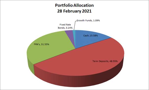
Council’s investment portfolio is well diversified in complying assets across the entire credit spectrum. It is also well diversified from a rating perspective. Credit quality is diversified and is predominately invested amongst the investment grade Authorised Deposit-Taking Institutions (ADIs) (being BBB- or higher), with a smaller allocation to unrated ADIs.
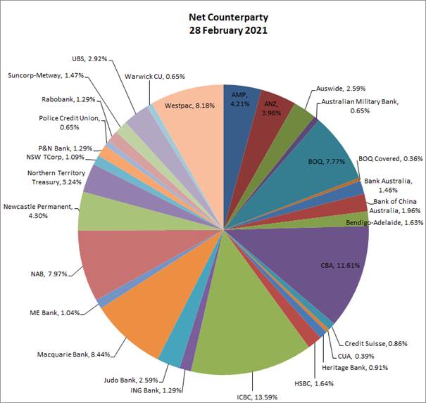
All investments are within the defined Policy limits, as outlined in the Rating Allocation chart below:
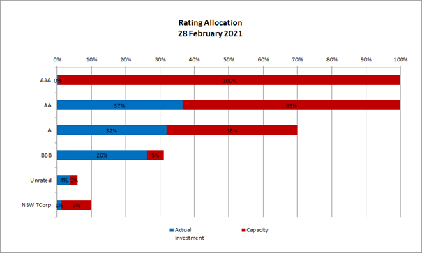
Investment Portfolio Balance
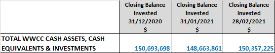
Monthly Investment Movements
Redemptions – Council redeemed the following investment securities during February 2021:
|
Institution and Type |
Amount |
Investment Term |
Interest Rate |
Comments |
|
ING Bank (A) Term Deposit |
$1M |
2 years |
2.82% |
This term deposit was redeemed on maturity and funds were reinvested in a new 5-year NAB Bank term deposit (see below). |
New Investments – Council purchased the following investment securities during February 2021:
|
Institution and Type |
Amount |
Investment Term |
Interest Rate |
Comments |
|
NAB (AA-) Term Deposit |
$1M |
5 years |
1.08% |
The NAB rate of 1.08% compared favourably to the rest of the market for this investment term – with the next best rate being 0.99%. |
Monthly Investment Performance
Interest/growth/capital gains/(losses) for the month totalled $83,494, which compares unfavourably with the budget for the period of $183,482 - underperforming budget for the month by $99,988.
Council’s underperformance to budget for February was mainly a result of the Floating Rate Note (FRN) portfolio experiencing a negative return for the month, with Council seeing a decrease in the principal value of the portfolio of (0.16%) (or $79,130).
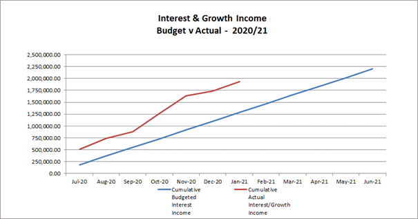
Over the past year, Councils investment portfolio has returned 1.75%, outperforming the AusBond Bank Bill index by 1.54%. This is expected to continue to reduce over the coming months and years with the expected continuation of the current low interest rate environment.
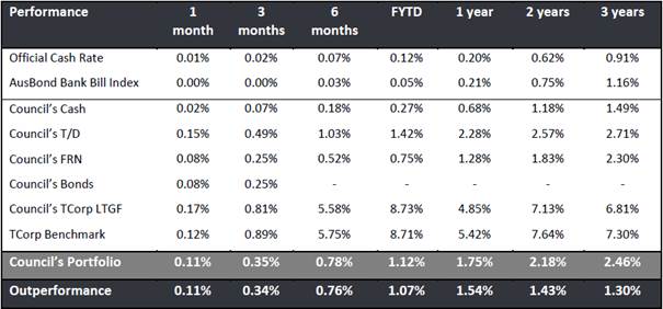
* The AusBond Bank Bill Index is the leading benchmark for the Australian fixed income market. It is interpolated from the RBA Cash rate, 1 month and 3-month Bank Bill Swap rates.
Report by Responsible Accounting Officer
I hereby certify that all of the above investments have been made in accordance with the provision of Section 625 of the Local Government Act 1993 and the regulations there under, and in accordance with the Investments Policy adopted by Council on 15 June 2020.
Carolyn Rodney
Responsible Accounting Officer
Policy and Legislation
Budget variations are reported in accordance with Council’s POL 052 Budget Policy.
Investments are reported in accordance with Council’s POL 075 Investment Policy.
Local Government Act 1993
Section 625 - How may councils invest?
Local Government (General) Regulation 2005
Section 212 - Reports on council investments
Link to Strategic Plan
Community Leadership and Collaboration
Objective: We have strong leadership
Outcome: We are accountable and transparent
Risk Management Issues for Council
This report is a control mechanism that assists in addressing the following potential risks to Council:
· Loss of investment income or capital resulting from ongoing management of investments, especially during difficult economic times
· Failure to demonstrate to the community that its funds are being expended in an efficient and effective manner
Internal / External Consultation
All relevant areas within the Council have consulted with the Finance Division in relation to the budget variations listed in this report.
The Finance Division has consulted with relevant external parties to confirm Council’s investment portfolio balances.
|
1⇩. |
Capital Works Program 2020.21 to 2030.31 |
|
|
Report submitted to the Ordinary Meeting of Council on Monday 22 March 2021 |
RP-8 |
RP-8 Section 356 Requests for Financial Assistance
Author: Craig Katsoolis
Director: Natalie Te Pohe
|
Summary: |
Council has received a number of fee waiver requests which are detailed for Council’s consideration. |
|
That Council: a in accordance with Section 356 of the Local Government Act 1993, provide financial assistance to Country Hope of $700 b note the proposed budget available for financial assistance requests for the remainder of the 2020/21 financial year |
Report
One (1) Section 356 financial assistance item is proposed for consideration at the 22 March 2021 Ordinary Council meeting, which is shown below:
Country Hope $700
Mick Small, Fundraising/Events Coordinator writes in his attached email:
“We have been using the Cross St Car park for the Country Hope Wheels Of Wagga, vehicle display. We do these events to raise much needed funds for local charity Country Hope. Providing emotional and financial support to the families of local children diagnosed with Cancer and other life threatening illnesses. It has been brought to my attention that we need to request a waiver of booking fees for our previous events and our up coming events, I thought this had already been done so please accept my apologies for not doing it in advance. We are at the carpark for approximately 3 hours and leave the carpark exactly how we found it each time. If council could please waive our fees, it would be great for our local charity. Thanks very much, Dates are as follows
|
Previous Dates |
Upcoming Dates |
|
16/01/2021 |
13/02/2021 |
|
08/11/2020 |
11/04/2021 |
|
11/10/2020 |
13/06/2021 |
|
|
18/08/2021” |
The proposed financial assistance of $700 (which will cover the above dates) is proposed to be funded from unallocated funds within the General Section 356 budget.
Fee Number 0719 – Sportsgrounds and Parks Not for profit – casual hire – per bookable space (includes schools outside LGA) Less than 1000 People of $100 per hire would be charged if this request was not considered favourably.
The above request aligns with Councils Strategic Plan “Community Place and Identity - Objective: Groups Programs and activities bring us together”.
Financial Implications
|
Section 356 Budget Summary |
|
|
Previously advised unallocated balance of 2020/21 Section 356 fee waiver financial assistance budget |
$6,464.46 |
|
1) Country Hope - $700 |
($700.00) |
|
Subtotal Fee Waivers included in this report – proposed to be funded from the Section 356 Budget |
($700.00) |
|
Balance of Section 356 fee waiver financial assistance budget for the remainder of the 2020/21 Financial Year |
$5,764.46 |
Policy and Legislation
POL 078 – Financial Assistance Policy
Link to Strategic Plan
Community Leadership and Collaboration
Objective: We have strong leadership
Outcome: We are accountable and transparent
Risk Management Issues for Council
N/A
Internal / External Consultation
Cross Directorate consultation has been undertaken as required.
|
1⇩. |
S356 Financial Assistance - Country Hope Wagga |
|
|
Report submitted to the Ordinary Meeting of Council on Monday 22 March 2021 |
RP-8 |
We have been using the Cross St Car park for the Country Hope Wheels Of Wagga, vehicle display. We do these events to raise much needed funds for local charity Country Hope. Providing emotional and financial support to the families of local children diagnosed with Cancer and other life threatening illnesses. It has been brought to my attention that we need to request a waiver of booking fees for our previous events and our up coming events, I thought this had already been done so please accept my apologies for not doing it in advance. We are at the carpark for approximately 3 hours and leave the carpark exactly how we found it each time. If council could please waive our fees, it would be great for our local charity. Thanks very much, Dates are as follows
Previous Dates
16/01/2021
08/11/2020
11/10/2020
Upcoming Dates
13/02/2021
11/04/2021
13/06/2021
18/08/2021
Thanks again
Regards
Mick
Mick Small
Fundraising/Events Coordinator

Country Hope
PO Box 134
WAGGA WAGGA NSW 2650
Mob: 0439 505 334
Phone: 1800 007 880
Fx: 02 6971 8966
Email: mick@countryhope.com.au
|
Report submitted to the Ordinary Meeting of Council on Monday 22 March 2021 |
RP-9 |
RP-9 COVID-19 Fast Track Event Sponsorship
Author: Fiona Hamilton
Director: Janice Summerhayes
|
Summary: |
Council is in receipt of one application from MerinoLink for the COVID-19 Fast Track Event Sponsorship Program for events held from 1 February to 30 June 2021. Council supported this approach in November 2020 as a response to COVID-19 impacts. The COVID-19 Fast Track Event Sponsorship Program currently closes on 31 March 2021 for events held up until 30 June 2021. Staff are currently working with a number of event organisers on new events that require more time to develop and submit a competitive ‘Fast Track’ application.
Staff are recommending an extension of this program for events to be held up until 31 July 2021 with applications closing 30 April 2021 or until funds are exhausted.
|
|
That Council: a authorise the General Manager or their delegate to enter into an agreement to sponsor MerinoLink for their MerinoLink Conference to the amount of $10,000 from the 2020/21 Events Sponsorship budget b approve the extension of the COVID-19 Fast Track Event Sponsorship Program for one month from 31 March 2021 to 30 April 2021 for events held until 31 July 2021. |
Report
Council has approved four Covid-19 Fast Track Events Sponsorship applications for events held from 1 February to 30 June 2021, as detailed in the Finance Section of this report. Council is in receipt of a further application for the COVID-19 Fast Track Event Sponsorship Program.
In line with the Major Events, Festivals and Films Sponsorship Policy (POL087) this application has been assessed by the Major Events Advisory Panel (the Panel) with the following funding amount recommended:
|
|
Organisation Name |
Event Name |
Amount Requested |
Funding Recommended |
|
1 |
MerinoLink |
MerinoLink 2021 |
$10,000 |
$10,000 |
Event Details:
1. MerinoLink 2021
The organiser is seeking $10,000 funding for their annual MerinoLink conference to be held 16 -18 June 2021 in Wagga Wagga at The Range Function Centre.
Event details:
· Date: 16 – 18 June 2021
· Expected attendance: 150-250 plus associates
· Visitors (from outside of LGA): 70
· Program:
o Lead in sessions
o Dinner at The Thirsty Crow Brewery
o Field trip at Graham Centre, NSW Department of Primary Industries and Charles Sturt University
· Duration: three days
· Venue: The Range
· Total event cost: $49,615
· Total amount requested: $10,000
The funding requested will be used for expanding the event platform to enable remote attendance, COVID safety and event promotion.
If successful in securing the requested funding the applicant will acknowledge Council’s funding through the provision of a trade display, signage, advertising in the conference materials and logo placement in social media.
The Panel has assessed this application against the COVID-19 Fast Track Events, Festival and Films Sponsorship Guidelines and recommends this business conference is funded $10,000 for the following reasons:
· The Riverina Murray Destination Management Plan 2018 identifies conferencing is identified as an important niche market for the Riverina
· The conference aligns to Council’s Community Strategic Plan Objective We are a centre for education and training’’ as part of the Growing Economy strategic objective
· Council’s Events Strategy and Action Plan 2020-2024 highlights the importance of promoting the city as a niche business conference location that align to the City’s priorities including agriculture
· The event provides benefit to local business, particularly following the cancellation of many of the city’s larger events
The COVID-19 Fast Track Event Sponsorship Program currently closes on 31 March 2021 for events held up until 30 June 2021. Staff are currently working with four event organisers on new events that are in their concept phases and require more time to develop and submit a competitive ‘Fast Track’ application. It is for this reason staff are recommending an extension of this program for events to be held up until 31 July 2021 with applications closing 30 April 2021 or until funds are exhausted.
Financial Implications
|
2020/21 COVID-19 Fast Track Events Sponsorship budget |
$100,000 |
|
Less previously approved Council sponsorship: |
|
|
· Murrumbidgee Turf Club (Southern District Racing Association’s Country Championships) |
(11,000) |
|
· Kylie Biltris, Art Starts Here (Murray Arts - Art Starts Here – Wagga Village Creative Event of Workshops) |
($7,818) |
|
· Ladysmith Tourist Railway Inc. (Ladysmith Railway Centenary Celebration) |
($4,000) |
|
· Catherine van der Rijt (Auspiced through Eastbourne Road Pty Ltd – The Drive 12 minute short film) |
($10,000) |
|
Subtotal Previously approved Council sponsorship |
($32,818) |
|
2020/21 COVID-19 Fast Track Events Sponsorship current budget available |
$67,182 |
|
Proposed budget allocations:
|
|
|
· MerinoLink (MerinoLink 2021 event), as per this report’s proposed recommendation |
($10,000) |
|
· Anzac Day 2021 Ceremony – COVID-19 safe event |
($13,000) |
|
Proposed 2020/21 COVID-19 Fast Track Events Sponsorship budget available for remainder of this financial year |
$44,182 |
Job consolidation number: 15308
Policy and Legislation
POL087 – Major Events, Festivals and Films Sponsorship
Link to Strategic Plan
Growing Economy
Objective: We are a hub for activity
Outcome: We have vibrant precincts
Risk Management Issues for Council
Financial risk if events not successful, mitigated through controls in sponsorship contracts with staged payment based on KPI targets.
Internal / External Consultation
|
|
|
Media |
Community Engagement |
Digital |
|||||||||||||
|
Rates notices insert |
Direct mail |
Letterbox drop |
Council news story |
Council News advert |
Media releases |
TV/radio advertising |
One-on-one meetings |
Your Say website |
Community meetings |
Stakeholder workshops |
Drop-in sessions |
Surveys and feedback forms |
Social media |
Email newsletters |
Website |
Digital advertising |
|
|
TIER |
|||||||||||||||||
|
Consult |
|
|
|
|
|
|
|
|
|
|
|
|
|||||
|
Involve |
|
|
|
x |
|
x |
|
|
|
x |
x |
x |
|||||
|
Collaborate |
|
|
|
|
|
|
|
x |
|
|
|
|
|
x |
|
|
|
|
1. |
MerinoLink Conference Application This matter is considered to be confidential under Section 10A(2) of the Local Government Act 1993, as it deals with: commercial information of a confidential nature that would, if disclosed, reveal a trade secret. - Provided under separate cover |
|
|
2. |
MerinoLink Conference Budget This matter is considered to be confidential under Section 10A(2) of the Local Government Act 1993, as it deals with: commercial information of a confidential nature that would, if disclosed, reveal a trade secret. - Provided under separate cover |
|
|
3. |
MerinoLink Conference Program This matter is considered to be confidential under Section 10A(2) of the Local Government Act 1993, as it deals with: commercial information of a confidential nature that would, if disclosed, reveal a trade secret. - Provided under separate cover |
|
|
4. |
MerinoLink Conference Sponsorship Packages This matter is considered to be confidential under Section 10A(2) of the Local Government Act 1993, as it deals with: commercial information of a confidential nature that would, if disclosed, reveal a trade secret. - Provided under separate cover |
|
|
Report submitted to the Ordinary Meeting of Council on Monday 22 March 2021 |
RP-10 |
RP-10 COUNCILLOR CONFERENCE - MURRAY DARLING ASSOCIATION NATIONAL CONFERENCE AND ANNUAL GENERAL MEETING
Author: Scott Gray
General Manager: Peter Thompson
|
Summary: |
The purpose of the MDA is to provide effective representation of local government and communities at state and federal level in the management of Basin resources by exchanging information; facilitating debate; and seeking to influence government policy. |
|
That Council endorse the Mayor to attend The Murray Darling Association National Conference and Annual General Meeting to be held in Wentworth on the 16 to 19 May 2021. |
|
|
Report
The Murray Darling Association National Conference and Annual General Meeting will be held in Wentworth on the 16 to 19 May 2021. The Mayor has expressed interest to attend the event as Council’s representative
Following the adversity of droughts, fires and Covid-19 we know that the towns, regions and countries to emerge quickest and strongest are those with innovative, connected local leadership.
It’s no surprise then that local government and the communities of the Murray Darling Basin are well placed to adapt and forge ahead in 2021 - and beyond. Basin councils have, after all, spent years building connections across catchments and communities.
With our rivers, our borders and even our attitudes increasingly fragmented, clever councils recognise the importance of innovation to restore and build connectivity.
Connectivity of communities is essential to our people. In the same way, a healthy river system must have connectivity of flows. There is no future on a dry system.
The MDA’s 77th National Conference & AGM is our opportunity to be part of the solution – to join the conversation, to inform future policy, and to engage with the innovators, scientists, educators and leaders of our time.
In a world forced to confront successive crises in 2020, the towns, regions and countries emerging quickest and strongest are those with innovative, connected local leadership.
This year's program reflects that now, more than ever, we must be connected to succeed:
· Connecting catchments and river systems is at the heart of a healthy Basin.
· Connecting leaders - local, state, federal and First Nations - is essential to our shared success.
· Connecting the many great plans for our nation will build confidence and prosperity.
· And, most importantly, after the challenges of 2020, connecting with each other.
Financial Implications
The registration cost per delegate at the early bird rate is $699.00. Transport, Accommodation and incidentals estimated at approximately $650.00 per delegate additional to the registration costs, bringing the total estimated cost for this conference to $1350.00.
$19,625 – Councillors’ Conference remaining budget available
($ 1,350) – Total estimated cost for conference
$18,275 – estimated remaining budget after endorsement
Policy and Legislation
POL 025 - Payment of Expenses and Provision of Facilities to Councillors.
Link to Strategic Plan
Community Leadership and Collaboration
Objective: We have strong leadership
Outcome: We have leaders that represent us
Risk Management Issues for Council
N/A
Internal / External Consultation
N/A
|
Report submitted to the Ordinary Meeting of Council on Monday 22 March 2021 |
RP-11 |
RP-11 RESOLUTIONS AND NOTICES OF MOTIONS REGISTERS
Author: Ingrid Hensley
General Manager: Peter Thompson
|
Summary: |
This report provides Councillors with an update on the status of all resolutions of Council including Notices of Motion. |
|
That Council receive and note the following registers: a Active Resolutions as at 16 March 2021 b Active Notice of Motions as at 16 March 2021 c Resolutions including Notice of Motions completed from 16 February 2021 to 16 March 2021 |
Report
The attached registers, outline details of each resolution with the following analysis provided as a snapshot as at 16 March 2021:
· 74 Active resolutions
· 19 Active Notices of Motions
· Nine (9) resolutions including Notice of Motions have been completed from 16 February 2021 to 16 March 2021
Financial Implications
N/A
Policy and Legislation
Council’s Code of Meeting Practice
Link to Strategic Plan
Community Leadership and Collaboration
Objective: We are informed and involved in decision making
Outcome: Everyone in our community feels they have been heard and understood
Risk Management Issues for Council
N/A
Internal / External Consultation
As notified during debate at the Ordinary Council Meeting held on 8 February 2021. Councillors were requested via the Councillor Bulletin on 26 February 2021 to provide feedback to Council on resolutions they believe to be missing from the register, in particular resolutions prior to this current term of Council.
At the date of publishing no advice from Councillors has been received.
|
1. |
Active Resolutions as at 16 March 2021 - Provided under separate cover |
|
|
2. |
Active Notice of Motions as at 16 March 2021 - Provided under separate cover |
|
|
3. |
Completed Resolutions from 16 February 2021 to 16 March 2021 - Provided under separate cover |
|
|
Report submitted to the Ordinary Meeting of Council on Monday 22 March 2021 |
M-1 |
M-1 FLOODPLAIN RISK MANAGEMENT ADVISORY COMMITTEE - MINUTES - EXTRAORDINARY MEETING 23 FEBRUARY 2021
Author: Shannon Coghlan
Director: Darren Raeck
|
Summary: |
The Floodplain Risk Management Advisory Committee met on 23 February 2021 to review and discuss the Wagga Wagga Major Overland Flow Floodplain Risk Management Study and Plan (MOFFS) and Tarcutta, Ladysmith and Uranquinty Floodplain Risk Management Studies and Plans (VOFFS) reports. |
|
That Council receive and note the minutes of the Floodplain Risk Management Advisory Committee extraordinary meeting held on 23 February 2021. |
Report
The Floodplain Risk Management Advisory Committee met on 23 February 2021 to review and discuss the Tarcutta, Ladysmith and Uranquinty Floodplain Risk Management Studies and Plans (VOFFS) and the Wagga Wagga Major Overland Flow Floodplain Risk Management Study and Plan (MOFFS). The minutes from this meeting are attached for Councillors’ reference.
Financial Implications
N/A
Policy and Legislation
N/A
Link to Strategic Plan
Community Leadership and Collaboration
Objective: We are informed and involved in decision making
Outcome: Everyone in our community feels they have been heard and understood
Risk Management Issues for Council
N/A
Internal / External Consultation
|
|
|
Media |
Community Engagement |
Digital |
|||||||||||||
|
Rates notices insert |
Direct mail |
Letterbox drop |
Council news story |
Council News advert |
Media releases |
TV/radio advertising |
One-on-one meetings |
Your Say website |
Community meetings |
Stakeholder workshops |
Drop-in sessions |
Surveys and feedback forms |
Social media |
Email newsletters |
Website |
Digital advertising |
|
|
TIER |
|||||||||||||||||
|
Consult |
|
|
|
|
x |
|
x |
x |
x |
|
|
|
x |
x |
|||
|
Involve |
|
|
|
|
|
|
|
|
|||||||||
|
Collaborate |
|
|
|
|
|
|
|
|
|
|
|
|
|
|
|
|
|
|
1⇩. |
FRMAC Minutes - Extraordinary Meeting - 23 February 2021 |
|
Reports submitted to the Ordinary Meeting of Council to be held on Monday 22 March 2021.
|
Report submitted to the Confidential Meeting of Council on Monday 22 March 2021 |
CONF-1 |
CONF-1 PROPERTY RATES MATTER
Author: Carolyn Rodney
Director: Natalie Te Pohe
This report is CONFIDENTIAL in accordance with Section 10A(2) of the Local Government Act 1993, which permits the meeting to be closed to the public for business relating to the following: -
(b) discussion in relation to the personal hardship of a resident or ratepayer.
|
Report submitted to the Confidential Meeting of Council on Monday 22 March 2021 |
CONF-2 |
CONF-2 Lake Albert Blue Green Algae Remediation (Update on Extended trial of Ultrasound Units)
Author: Rupesh Shah
Director: Darren Raeck
This report is CONFIDENTIAL in accordance with Section 10A(2) of the Local Government Act 1993, which permits the meeting to be closed to the public for business relating to the following: -
(d) (i) commercial information of a confidential nature that would, if disclosed, prejudice the commercial position of the person who supplied it.
Report submitted to the Confidential Meeting of Council on Monday 22 March 2021. CONF-3
CONF-3 RFT2018-16 PROVISION OF TRADE SERVICES (REFRESH)
Author: Sylvester Otieno
Director: Warren Faulkner
This report is CONFIDENTIAL in accordance with Section 10A(2) of the Local Government Act 1993, which permits the meeting to be closed to the public for business relating to the following: -
(d) (ii) commercial information of a confidential nature that would, if disclosed, confer a commercial advantage on a competitor of the Council.
|
Report submitted to the Confidential Meeting of Council on Monday 22 March 2021 |
CONF-4 |
CONF-4 RFT2021-16 SUPPLY OF MEMORIAL PLAQUES, VASES AND OTHER SUPPLIES
Author: Henry Pavitt
Director: Warren Faulkner
This report is CONFIDENTIAL in accordance with Section 10A(2) of the Local Government Act 1993, which permits the meeting to be closed to the public for business relating to the following: -
(d) (i) commercial information of a confidential nature that would, if disclosed, prejudice the commercial position of the person who supplied it.
|
Report submitted to the Confidential Meeting of Council on Monday 22 March 2021 |
CONF-5 |
CONF-5 Proposed Assignment of Airport Sub-Lease - Light Aircraft Precinct Hangar Site 18
Author: David Bolton
Director: Michael Keys
This report is CONFIDENTIAL in accordance with Section 10A(2) of the Local Government Act 1993, which permits the meeting to be closed to the public for business relating to the following: -
(d) (iii) commercial information of a confidential nature that would, if disclosed, reveal a trade secret.