Reports submitted to the Floodplain Risk Management Advisory Committee to be held on Thursday 10 August 2023.
Floodplain Risk Management
Advisory Committee AGENDA AND
BUSINESS PAPER
Thursday 10 August 2023
ORDER OF BUSINESS:
CLAUSE PRECIS
PAGE
ACKNOWLEDGEMENT
OF COUNTRY 2
APOLOGIES
2
Confirmation of Minutes
CM-1 Floodplain
Risk Management Advisory Committee Minutes - 8 June 2023 2
DECLARATIONS
OF INTEREST 2
Reports from Staff
RP-1 2021-22-FM-0032
- Uranquinty Levee Upgrade - Investigation and Design 3
RP-2 2018-19-FM-0071
- North Wagga Flood Mitigation Options 5
RP-3 2021-22-FM-0024
- Glenfield Drain and Flowerdale Storage Flood Mitigation Works 7
RP-4 2021-22-FM-0039
- Lake Albert Flood Mitigation Options –Feasibility Study 9
RP-5 2022-FMP-0103
Humula and Mangoplah Flood Studies 10
RP-6 Local
& Regional Risk Reduction Stream - Levee Pump Augmentation 11
RP-7 SW01
- Incarnie Crescent, Stormwater Augmentation - Preparing Australian Communities
- Local Grant Scheme 12
RP-8 DPE
Floodplain Manual Revision 13
QUESTIONS WITH NOTICE 83
ACKNOWLEDGEMENT OF
COUNTRY
APOLOGIES
Confirmation
of Minutes
CM-1 Floodplain Risk Management Advisory
Committee Minutes - 8 June 2023
|
Recommendation
That the
Minutes of the proceedings of the Floodplain Risk Management Advisory
Committee Meeting held on 8 June 2023 be confirmed as a true and accurate
record.
|
|
1⇩.
|
Minutes - FRMAC - 8 June 2023
|
84
|
DECLARATIONS OF INTEREST
|
Report submitted to the Floodplain Risk Management Advisory Committee on Thursday 10 August 2023
|
RP-1
|
Reports
from Staff
RP-1 2021-22-FM-0032 - Uranquinty Levee
Upgrade - Investigation and Design
Author: Andrew
Mason
Executive: Phil McMurray
|
Summary:
|
The project
is progressing as per the required program. Preliminary fieldwork and
analysis has been completed
|
|
That the
Floodplain Risk Management Advisory Committee receive and note the update
provided in relation to the Uranquinty Levee project.
|
Royal
HaskoningDHV (RHDHV) have now completed the majority of the background
investigations, this includes:
· Site inspection of
the proposed levee alignment.
· Geotechnical
investigations and boreholes along the alignment.
· Survey
investigation of the levees.
· Services investigation
of the levees.
· Review of
hydraulic modelling files including results.
This
information is being processed and they have commenced some concept design
optioneering of the proposed works.
N/A
N/A
Safe and
Healthy Community
Objective: Our community
feel safe
Be responsive to
emergencies
Risk Management Issues for
Council
N/A
Internal / External
Consultation
N/AN/A
|
Report submitted to the Floodplain Risk Management Advisory Committee on Thursday 10 August 2023
|
RP-2
|
RP-2 2018-19-FM-0071 - North Wagga Flood
Mitigation Options
Author: Andrew
Mason
Executive: Phil McMurray
|
Summary:
|
The project
is progressing well and reaching some critical milestones in the next few
weeks including the major community consultation workshop and forum.
|
|
That the
Floodplain Risk Management Advisory Committee receive and note the update
provided in relation to the North Wagga Flood Mitigation Options Project.
|
Key events that
have occurred in the last couple of weeks include:
· organisation of
Councillor Workshop and public forum
· recruitment for
public forum and targeted interviews
o there has been an enthusiastic
response by residents in North Wagga willing to participate in the forum.
· development of
workshop and forum information packages
· further detailed
environmental analysis by NGH to provide an approximate economic cost for
option L4B. This extra work will cost $27,775 incl GST.
This environmental analysis will allow
for the development of an approximate economic cost of the environmental work
required for option L4B.
If Option L4B is the preferred option
from the feasibility study, then the Biodiversity Assessment work completed for
this study will then determine if a significant impact is considered likely. If
so, a Species Impact Statement or a Biodiversity Development Assessment Review
(BDAR) or a referral to the Commonwealth Environment Department may be
required. If no significant impact is anticipated a Review of Environmental
Factors can be prepared.
A BDAR will have a cost of approximately
$100,000 and a timeframe for completion of 12-14 months.
A Biodiversity Development Assessment Report (BDAR) is a
report document prepared by an Accredited Biodiversity Assessor consultant that
identifies how a proponent of a Development Application (DA) or State
Significant Development (SSD) in New South Wales, Australia will avoid,
minimise and offset impacts from their proposed development upon native
vegetation or threatened species listed under the New South Wales Biodiversity
Conservation Act 2016 and the NSW Biodiversity
Conservation Regulation 2017. The BDAR addresses the requirements of
the NSW Biodiversity Offset Scheme.
N/A
N/A
Safe and
Healthy Community
Objective: Our community
feel safe
Be responsive to
emergencies
Risk Management Issues for
Council
N/A
Internal / External
Consultation
N/A
|
Report submitted to the Floodplain Risk Management Advisory Committee on Thursday 10 August 2023
|
RP-3
|
RP-3 2021-22-FM-0024 - Glenfield Drain
and Flowerdale Storage Flood Mitigation Works
Author: Andrew
Mason
Executive: Phil McMurray
|
Summary:
|
Lyall and
Associates have provided an update on the project. It indicates there may be
a need for cost and budget variations.
|
|
That the
Floodplain Risk Management Advisory Committee receive and note the update
provided in relation to the Glenfield Drain and Flowerdale Storage Area Flood
Mitigation Works Project.
|
From Lyall and
Associates:
We have
reviewed the Wagga MOFFS TUFLOW Model and advise that the following updates are
required so that it is fit for undertaking the Glenfield Road Drain feasibility
study:
· Reduce the cell size to 2.5 m
(from 5 m) to more accurately define the capacity of the overland flow paths.
· Incorporate additional
stormwater pits and pipes, particularly in the headwaters of the study area to
ensure that the rate and volume of runoff that discharges to each detention
basin is accurately represented.
· Update the location where the
discharge hydrographs are injected into the TUFLOW model.
In addition to
the above, while we have not completed the assessment, we also anticipate that
it will be necessary to update the way buildings are represented in the model
and the invert levels of the already modelled piped drainage system.
Note that we
have already made the following updates to the Wagga MOFFS TUFLOW Model as part
of the work that we are currently undertaking for Council in regards the
proposed redevelopment of No. 190-205 Morgan Street:
· Incorporate the latest (2020)
LiDAR survey data as the base model to define the topography in the study area
(note that the Wagga MOFFSS model relied on LiDAR survey data that were
captured in 2008).
· Update details of the pipes
through the levee at the Flowerdale Storage Area in order to assess flood
behaviour in the lower reaches of the Glenfield Road Drain catchment when the
river levels are not elevated.
· Incorporate details of the
existing pump in the Flowerdale Storage Area in order to assess flood behaviour
in the lower reaches of the Glenfield Road Drain catchment when the
Murrumbidgee River is in flood.
· We have removed Areal
Reduction Factors (as they are not suitable in the study area) from the
hydrologic model that was used to derive inflow hydrographs to the Wagga MOFFS
TUFLOW Model. The hydrologic model has been rerun and discharge
hydrographs has been exported for input to the TUFLOW model.
Other potential
updates to the hydrologic model that are recommended, but which may need to
form part of a future scope of work given programme related time constraints
imposed by DPE include:
· Refine the sub-catchment
boundaries across the urbanised parts of the study area based on the details of
the piped drainage system and localised topographic features that influence
overland flow (such as the crown of the road).
· Update the hydrologic model so
that the urbanised sub-catchments are modelling using a hydrologic model that
has been developed to derive runoff from developed sub-catchments (such as the
IL-CL model in DRAINS).
We have been
liaising with Councils Principal Engineer Design Services, Bede Lane, as to
whether there are any additional survey requirements, our surveyor has advised
that he will be in the field commencing Monday 21 August 2023 to undertake the
basin survey. Our surveyors will advise Council of stormwater structures
that are inaccessible by hand, with mechanical assistance to be provided that
will enable access to structures that the surveyors are unable to lift.
Locations where additional survey may be required are also being identified,
that these areas may be captured during this time. As this work will
attract additional costs, we will advise you of the outcomes of our discussions
with Bede once our investigations are completed.
N/A
N/A
Safe and
Healthy Community
Objective: Our community
feel safe
Be responsive to
emergencies
Risk Management Issues for
Council
N/A
Internal / External
Consultation
N/A
|
Report submitted to the Floodplain Risk Management Advisory Committee on Thursday 10 August 2023
|
RP-4
|
RP-4 2021-22-FM-0039 - Lake Albert Flood
Mitigation Options –Feasibility Study
Author: Andrew
Mason
Executive: Phil McMurray
|
Summary:
|
There is a
slight delay in this project while the procurement and contract process are
finalised.
|
|
That the
Floodplain Risk Management Advisory Committee receive and note the update
provided in relation to the Lake Albert Flood Mitigation Project.
|
A workplan and cost variation has been
submitted to DPE for approval. Once this is finalised the consultant will be
able to commit resources to this project as per their workplan and program.
N/A
N/A
Safe and
Healthy Community
Objective: Our community
feel safe
Be responsive to
emergencies
Risk Management Issues for
Council
N/A
Internal / External
Consultation
N/A
|
Report submitted to the Floodplain Risk Management Advisory Committee on Thursday 10 August 2023
|
RP-5
|
RP-5 2022-FMP-0103 Humula and Mangoplah
Flood Studies
Author: Andrew
Mason
Executive: Phil McMurray
|
Summary:
|
The
procurement process has been completed and a preferred consultant has been
determined.
|
|
That the
Floodplain Risk Management Advisory Committee receive and note the update
provided in relation to the Humula and Mangoplah Flood Studies Project.
|
The procurement
process for this project has been finalised and a Workplan will be provided to
DPE for approval before the consultant is fully appointed to this project. At
this point in time the grant for this project is $80,000 and we have expended
$26,000 on the procurement of LiDar data. The consultant budget for this
project is in excess of $100,000 and so a minor variation will need to be
submitted to DPE as a part of the approval process.
N/A
N/A
Safe and
Healthy Community
Objective: Our community
feel safe
Be responsive to
emergencies
Risk Management Issues for
Council
N/A
Internal / External
Consultation
N/A
|
Report submitted to the Floodplain Risk Management Advisory Committee on Thursday 10 August 2023
|
RP-6
|
RP-6 Local & Regional Risk Reduction
Stream - Levee Pump Augmentation
Author: Andrew
Mason
Executive: Phil McMurray
|
Summary:
|
A consultant
has been appointed for this project.
|
|
That the
Floodplain Risk Management Advisory Committee receive and note the update
provided in relation to the Levee Pump Augmentation Project.
|
Stantec are the
preferred consultant of this project and Council is awaiting a workplan and
program from the consultant for this project to begin.
N/A
N/A
Community
leadership and collaboration
Objective: Wagga Wagga has
strong community leadership and a shared vision for the future
Plan long term for the
future of Wagga Wagga
Risk Management Issues for
Council
N/A
Internal / External
Consultation
N/A
|
Report submitted to the Floodplain Risk Management Advisory Committee on Thursday 10 August 2023
|
RP-7
|
RP-7 SW01 - Incarnie Crescent,
Stormwater Augmentation - Preparing Australian Communities - Local Grant Scheme
Author: Andrew
Mason
Executive: Phil McMurray
|
Summary:
|
This project
has been handed over to the Sewer and Stormwater team for implementation
|
|
That the
Floodplain Risk Management Advisory Committee receive and note the update
provided in relation to the Incarnie Crescent Stormwater Augmentation
project.
|
The design has been
completed and this project is currently with the Council Sewer and Stormwater
team for implementation.
N/A
N/A
Community
leadership and collaboration
Objective: Wagga Wagga has
strong community leadership and a shared vision for the future
Plan long term for the
future of Wagga Wagga
Risk Management Issues for
Council
N/A
Internal / External
Consultation
N/A
|
Report submitted to the Floodplain Risk Management Advisory Committee on Thursday 10 August 2023
|
RP-8
|
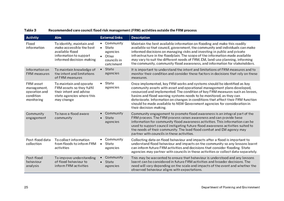
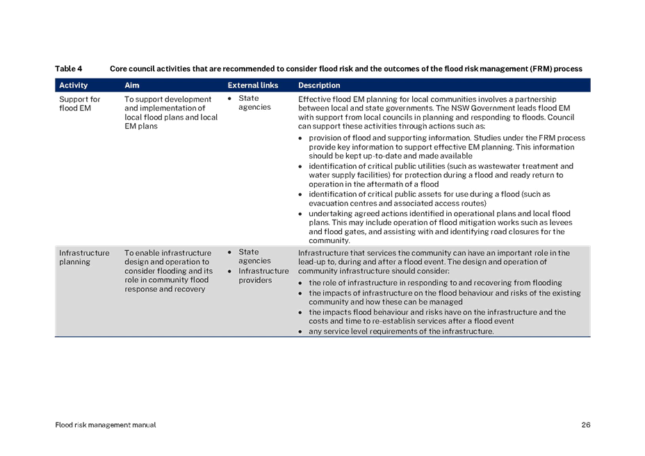
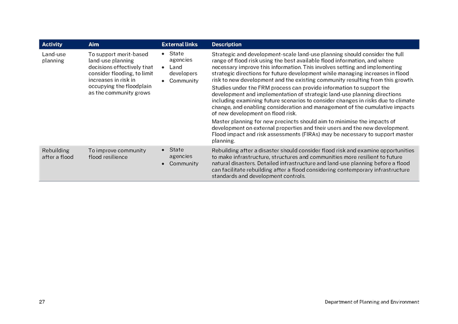
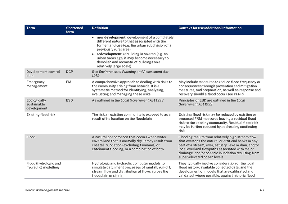
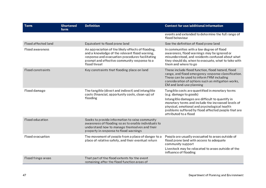
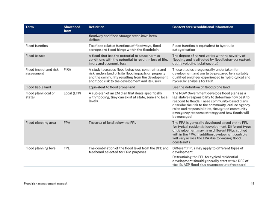
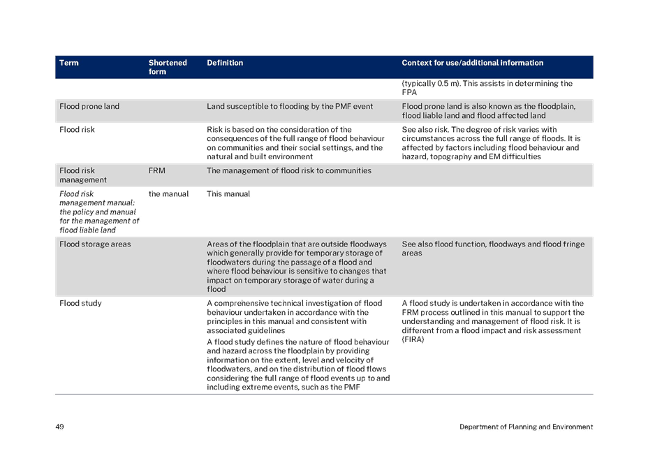
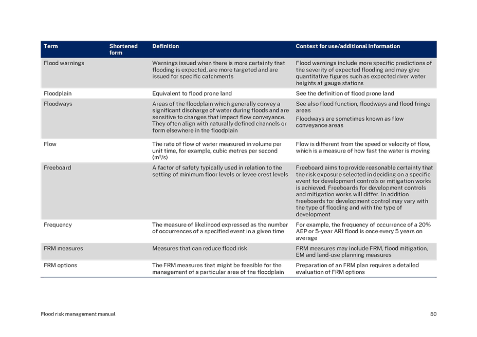
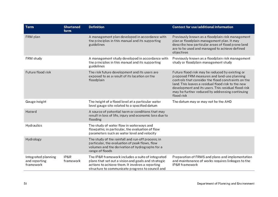
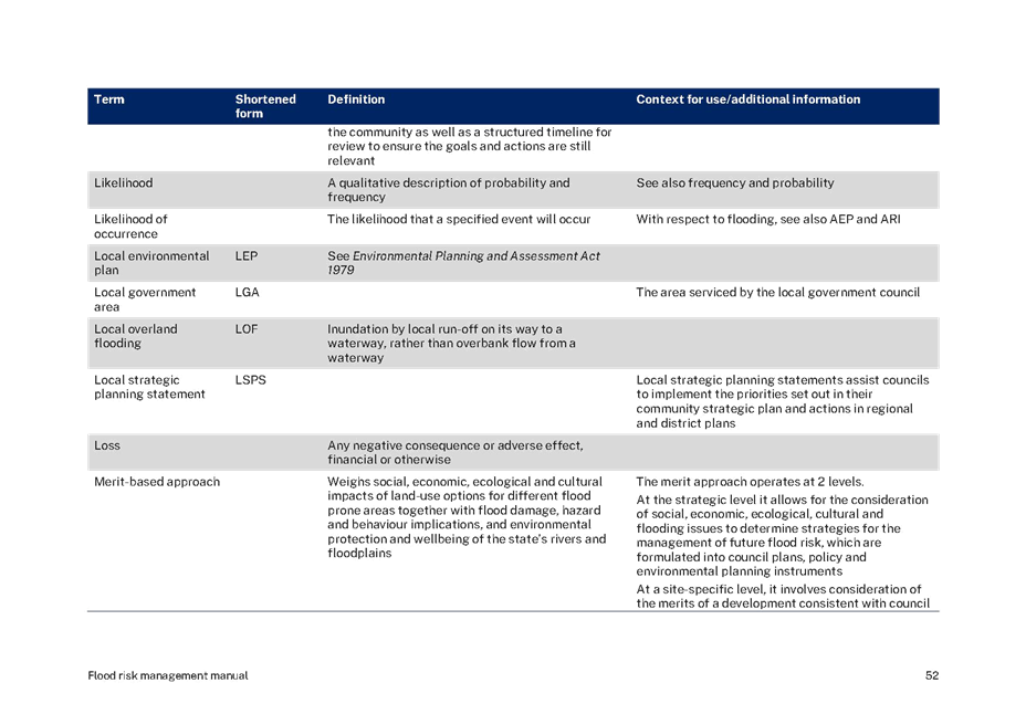
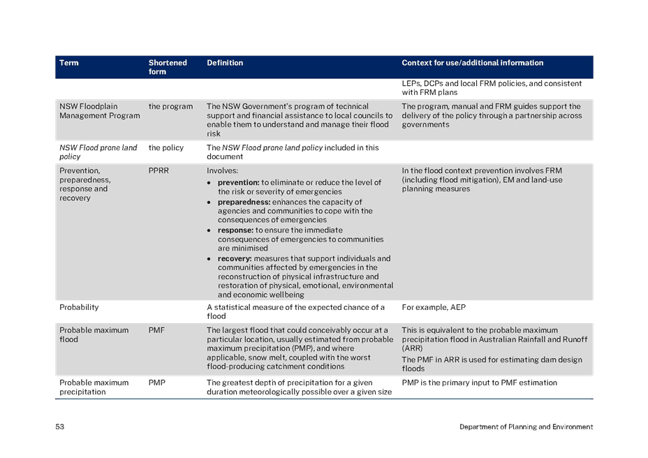
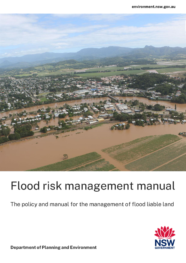
RP-8 DPE Floodplain Manual Revision
Author: Andrew
Mason
Executive: Phil McMurray
|
Summary:
|
DPE have
issued a new Flood risk management manual.
|
|
That the
Floodplain Risk Management Advisory Committee receive and note the update
provided in relation to the update of the Flood Risk Management Manual by the
NSW Department of Planning and Environment.
|
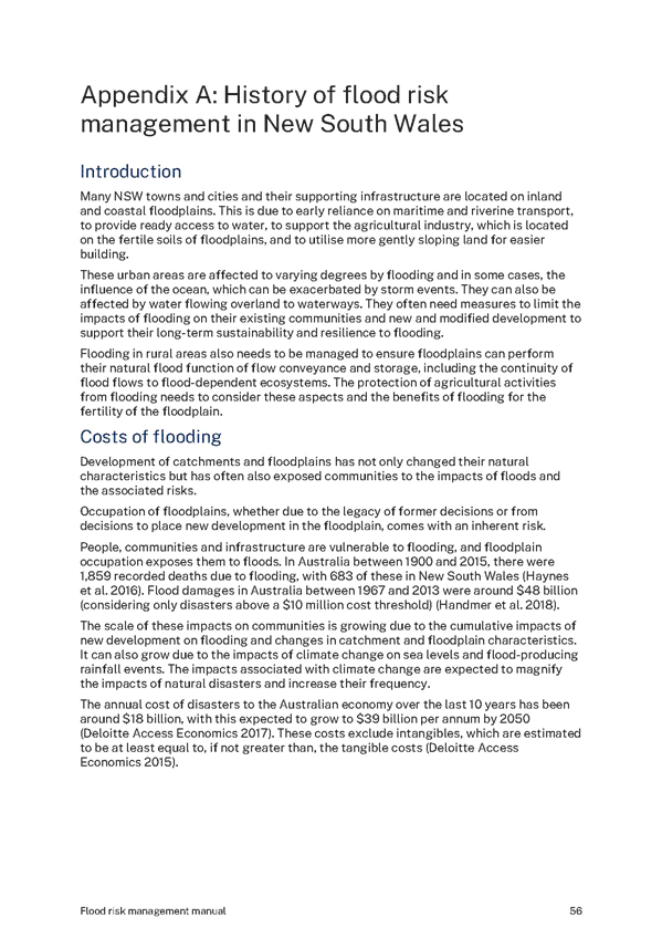
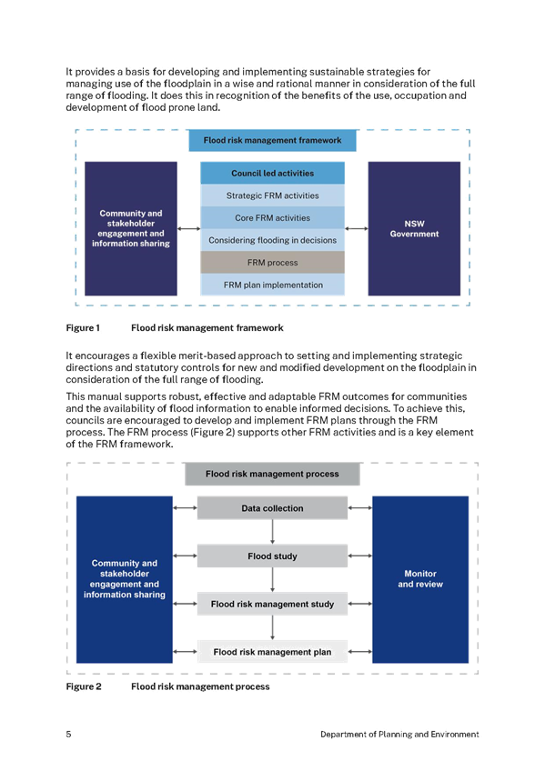
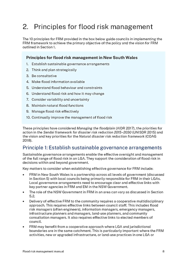
Flooding results in significant risk to many
communities across New South Wales. This risk stems from human interaction with
flooding through the occupation and use of floodplains.
Since 1984 the NSW Flood Prone Land Policy (the
policy) has set the direction for Flood Risk Management (FRM) in New South
Wales. In 1986 the NSW Government released the first Floodplain Development
Manual to support policy implementation. The policy and manual have since
evolved in response to significant flood events, reviews and improvements in
national and international flood risk management practice.
The policy as outlined in this document sets
the direction for FRM in New South Wales. The Flood Risk Management Manual:
the Policy and Manual for The Management of Flood Liable Land (this manual)
and its toolkit support the implementation of the Policy through the combined
efforts of all levels of government.
This manual (including the policy) replaces the Floodplain
Development Manual (DIPNR 2005) as the NSW Government’s manual
relating to the management of flood liable land in accordance with section 733
of the Local Government Act 1993 (LG Act). This provides councils,
statutory authorities, and state agencies and their staff, with indemnity for
decisions they make and information they provide in accordance with the manual.
Financial Implications
N/A
N/A
Safe and
Healthy Community
Objective: Our community
feel safe
Be responsive to
emergencies
Risk Management Issues for
Council
N/A
Internal / External
Consultation
N/A
|
1⇩.
|
DPE Flood Risk Management Manual 2023
|
|
|
Report submitted to the Floodplain Risk Management Advisory Committee on Thursday 10 August 2023
|
RP-8
|


Reports submitted to the Floodplain Risk Management Advisory Committee to be held on Thursday 10 August 2023.
QUESTIONS WITH NOTICE
Reports submitted to the Floodplain Risk Management Advisory Committee to be held on Thursday 10 August 2023.