Agenda
and
Business Paper
To be held on
Thursday
16 November 2023
at 9.30am
Civic Centre cnr Baylis and Morrow Streets,
Wagga Wagga NSW 2650 (PO Box 20)
P 1300 292 442
P council@wagga.nsw.gov.au
wagga.nsw.gov.au
Agenda
and
Business Paper
To be held on
Thursday
16 November 2023
at 9.30am
Civic Centre cnr Baylis and Morrow Streets,
Wagga Wagga NSW 2650 (PO Box 20)
P 1300 292 442
P council@wagga.nsw.gov.au
wagga.nsw.gov.au
Reports submitted to the Traffic Committee to be held on Thursday 16 November 2023.
Traffic Committee AGENDA AND BUSINESS PAPER
Thursday 16 November 2023
ORDER OF BUSINESS:
CLAUSE PRECIS PAGE
ACKNOWLEDGEMENT OF COUNTRY 2
APOLOGIES 2
Confirmation of Minutes
CM-1 CONFIRMATION OF MINUTES - 14 SEPTEMBER 2023 LOCAL TRAFFIC COMMITTEE MEETING 2
DECLARATIONS OF INTEREST 2
Reports
RP-1 Response to Notice of Motion - Special Events and Victory Memorial Gardens 3
RP-2 Fernleigh Road - NO STOPPING and associated traffic controls 13
RP-3 Tasman Road / Edison Road Intersection Upgrade 62
RP-4 Proposed No Parking Signs - 24 Bolton Street Wagga Wagga 67
RP-5 Installation of Giveway Sign and Line Marking at the intersection of Birch Road and Brunskill Road 74
RP-6 Crampton Street Carpark - Installation of Disabled Parking Signs 77
RP-7 Keajura Road - Linemarking 80
RP-8 Proposed Linemarking for various existing roundabouts 84
RP-9 2024 MEETING SCHEDULE 88
QUESTIONS WITH NOTICE 91
Wagga Wagga City Council acknowledges the traditional custodians of the land, the Wiradjuri people, and pays respect to Elders past, present and future and extends our respect to all First Nations Peoples in Wagga Wagga.
We recognise and respect their cultural heritage, beliefs and continuing connection with the land and rivers. We also recognise the resilience, strength and pride of the Wiradjuri and First Nations communities
CM-1 CONFIRMATION OF MINUTES - 14 SEPTEMBER 2023 LOCAL TRAFFIC COMMITTEE MEETING
|
That the Minutes of the proceedings of the Local Traffic Committee Meeting held on the 14 September 2023 be confirmed as a true and accurate record.
|
|
1⇩. |
Minutes - Traffic Committee - 14 September 2023 |
92 |
|
Report submitted to the Traffic Committee on Thursday 16 November 2023 |
RP-1 |
RP-1 Response to Notice of Motion - Special Events and Victory Memorial Gardens
Author: Warren Faulkner
|
That the Local Traffic Committee receive and note the report and provide any further advice considered necessary. |
Report
At the Ordinary Meeting of Council on the 10 January 2022, Councillor Tim Koschel presented a Notice of Motion concerning special events at the Victory Memorial Gardens (VMG) and requested that Council:
a receive a Report in relation to:
i Options for Special Event Drop off Zones for special events
ii Usage of the Victory Memorial Gardens for special events, and including (but not limited to):
· A list of all major events and non-major events, including school formals etc., that have been reported to Council
· The opportunity to have an event registry log for non-major events, so organisers can register an event with Council
· The current parking situation during these events and the opportunity of changing bus zones to include drop-off zones to allow for community to safely attend during these events
b Provide a copy of the Report to the Local Traffic Committee
The content in this report will provide the basis of the report back to Council on the 11 December 2023 and is being used to satisfy (b) of the request above.
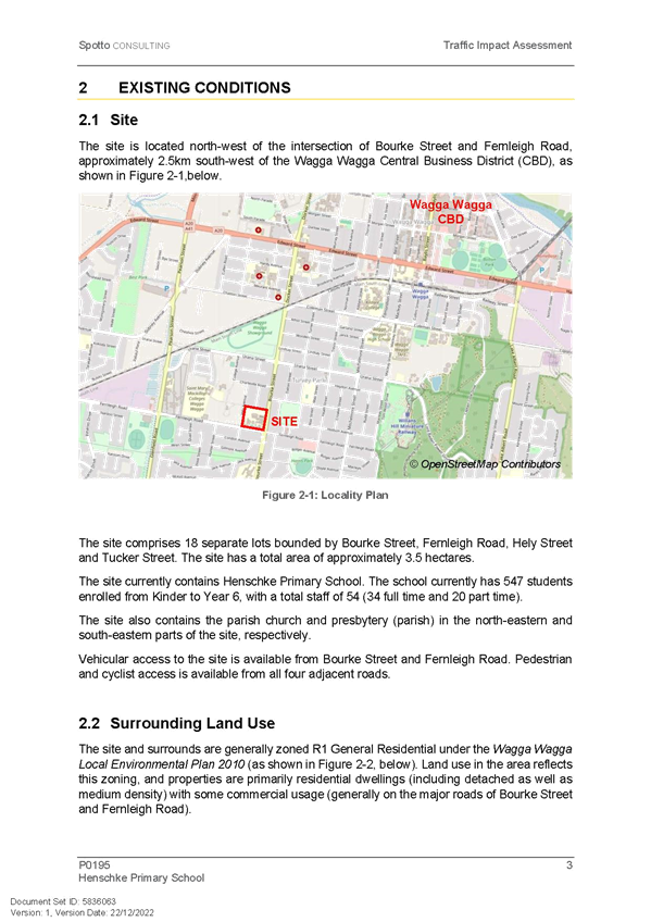
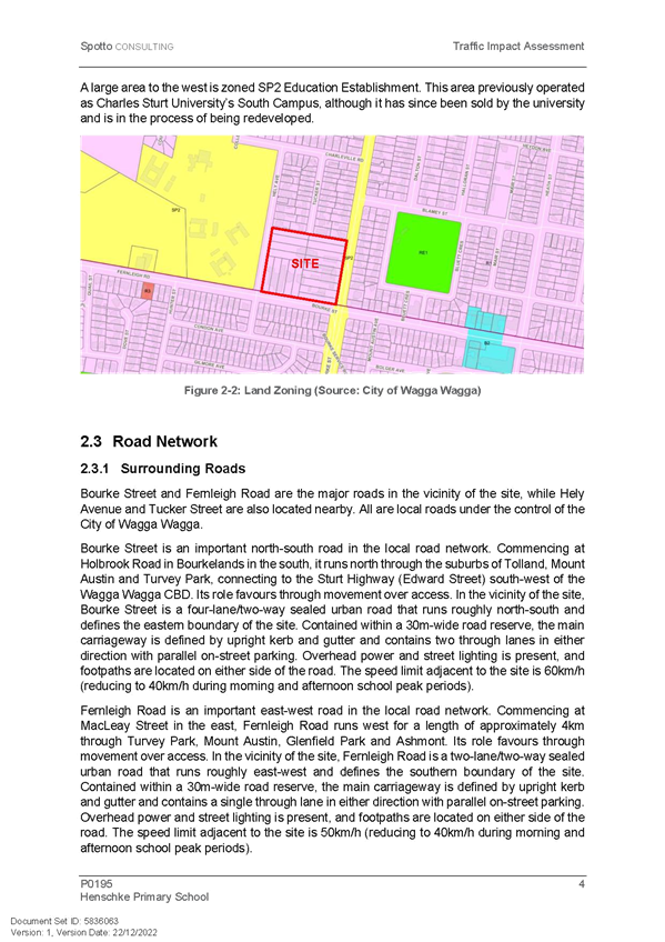
Victory Memorial Gardens is bounded by the Wollundry Lagoon to the north, Baylis Street to the east, Morrow Street to the south and Ivan Jack Drive to the west.
There is no public off-street car park in the Gardens.
On-Street Car Parking immediately adjoining the gardens is only available on Morrow Street (13 x 2P parallel parking bays 8:30am-6pm Mon-Fri, 8:30am-12pm Sat) and Baylis Street (3 x 1P parallel parking bays 8:30am-6pm Mon-Fri, 8:30am-12:30pm Sat). There is no On-Street Parking available on Ivan Jack Drive.
On-Street Parking is available on the opposite side of Morrow Street (12 x 1P parallel parking bays 8:30am-6pm Mon-Fri, 8:30am-12:30pm Sat plus 4 unrestricted parallel parking bays) and Baylis Street (6 x 1P parallel parking bays 8:30am-6pm Mon-Fri, 8:30am-12:30pm Sat) next to the Gardens.
An Off-Street public car park is also available on the opposite side of Morrow Street near its intersection with Ivan Jack Drive that has 6 x 1P 900 parking bays 8:30am-6pm Mon-Fri, 8:30am-12:30pm Sat and 9 unrestricted 900 parking bays.
There is 2 x parallel disabled parking only bays and a 15m Bus Zone (7am-7pm Sun-Wed, 7am-10pm Thur-Fri) on Baylis Street, 2 x 5.5m No Parking Zones and a 32m No Parking Zone – Tourist Bus Exempt Zone on Morrow Street immediately adjoining the gardens. A 7m No Parking Zone exists on the opposite side of Baylis Street next to the Gardens.
NSW Road Rule 168 for No Parking Zones is:
168 No parking signs
(1) The driver of a vehicle must not stop on a length of road or in an area to which a no parking sign applies, unless the driver:
(a) is dropping off, or picking up, passengers or goods, and
(b) does not leave the vehicle unattended, and
(c) completes the dropping off, or picking up, of the passengers or goods, and drives on, as soon as possible and, in any case, within the required time after stopping.
Maximum penalty: 20 penalty units.
(2) For this rule, a driver leaves a vehicle unattended if the driver leaves the vehicle so the driver is over 3 metres from the closest point of the vehicle.
(3) In this rule:
required time means:
(a) if information on or with the sign indicates a time—the indicated time, or
(b) if there is no indicated time—2 minutes, or
(c) if there is no indicated time, or the indicated time is less than 5 minutes, and rule 206 applies to the driver—5 minutes.
Note 1. With is defined in the Dictionary.
Note 2. Rule 206 applies to a driver if the driver’s vehicle displays a current parking permit for people with disabilities and the driver complies with the conditions of use of the permit.
As outlined above, there are 4 No Parking Zones on Morrow Street and Baylis Street next to the gardens, hence these are the Drop off Zones for events in the gardens. Conservatively, these zones can cater for up to seven vehicles to drop-off passengers at any one time.
NSW Road Rule 179 allows Loading Zones to be used to drop off or pick up passengers. There are 2 Loading Zones within 100m of the Victory Memorial Gardens, one is located on Baylis Street on the southeast corner of its intersection with Morrow Street and the other is located next to the Civic Centre on Morrow Street.
In summary, there is 6 drop off zones within 100m of the Victory Memorial Gardens, 53 car parking bays on Morrow Street and Baylis Street next to the Gardens, 4 Disabled Parking Bays and a Bus Stop.
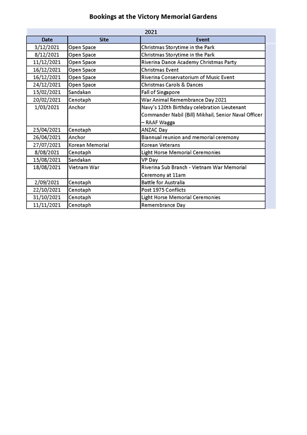
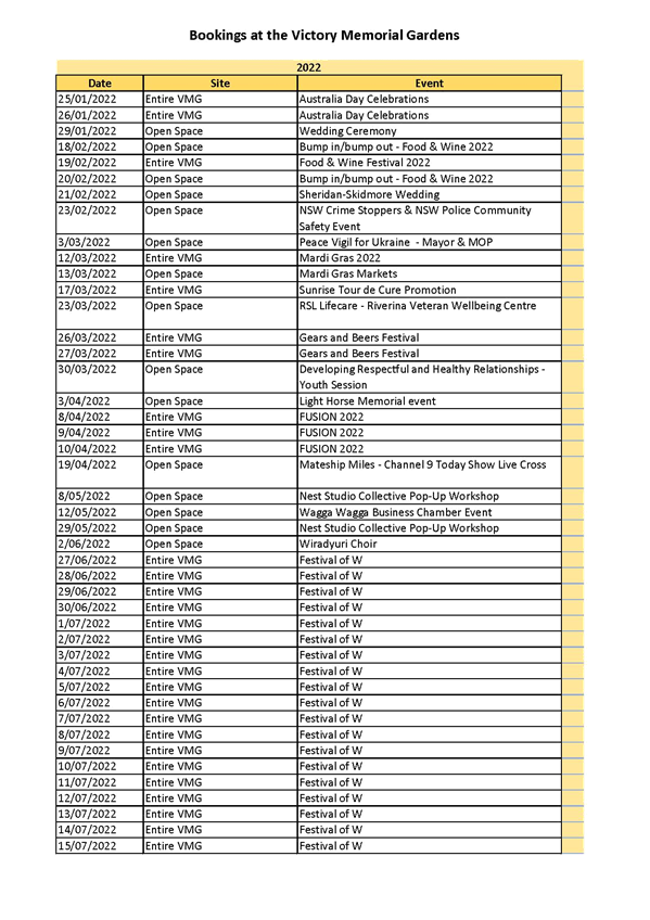
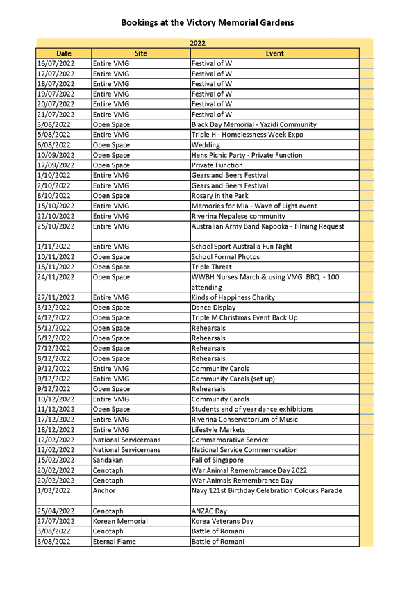
A copy of the list of all major events and non-major events, including school formals, etc that have been reported to Council over the last three years is attached for the information of the Committee.
Given the list of events that have occurred over the last 3 years at the Victory Memorial Gardens and that Council does not regularly receive complaints from customers about the lack of drop off zones, officers consider that the current arrangements are adequate to service the Victory Memorial Gardens and the events that it caters for and that no further action is required.
Risk Management Issues for Council
There are no risk management issues associated with this report for Council
Internal / External Consultation
Councils
|
1⇩. |
Bookings at the Victory Memorial Gardens |
|
|
Report submitted to the Traffic Committee on Thursday 16 November 2023 |
RP-2 |
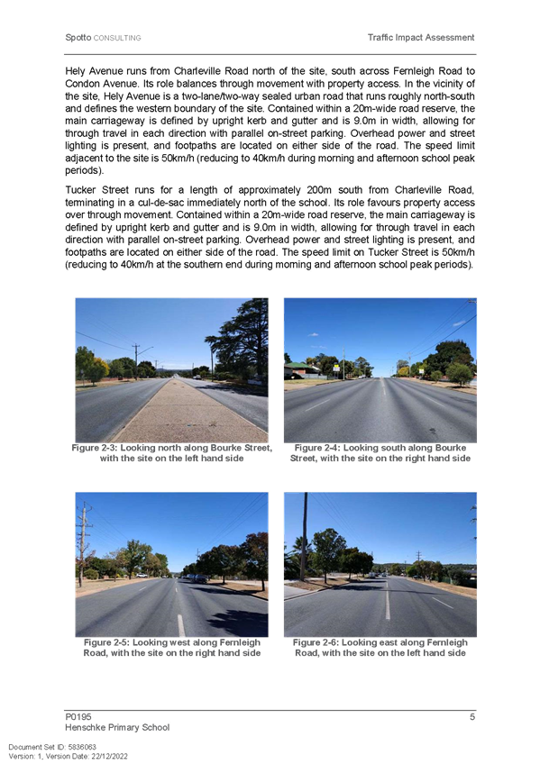
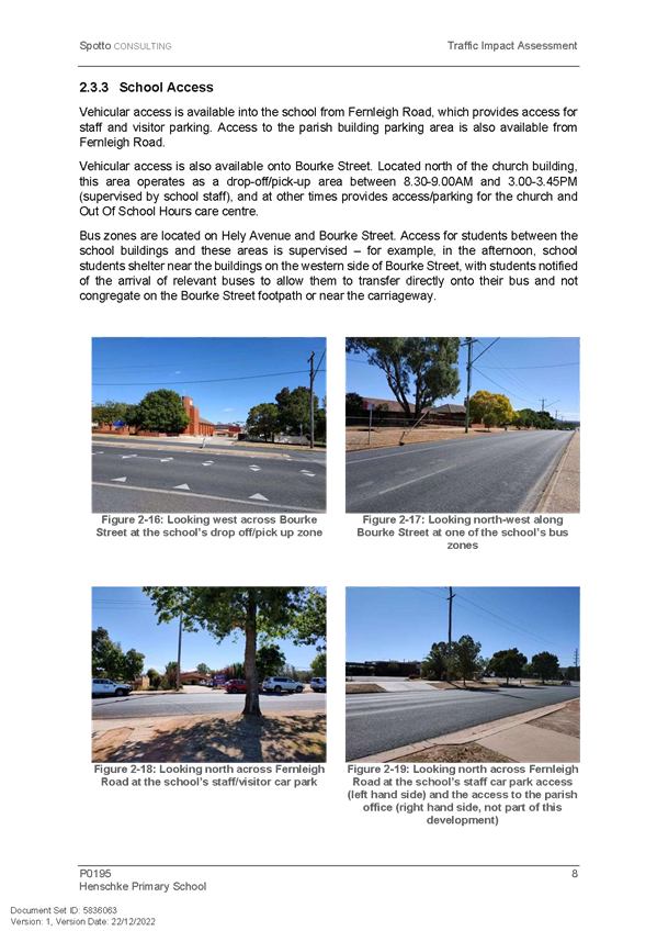
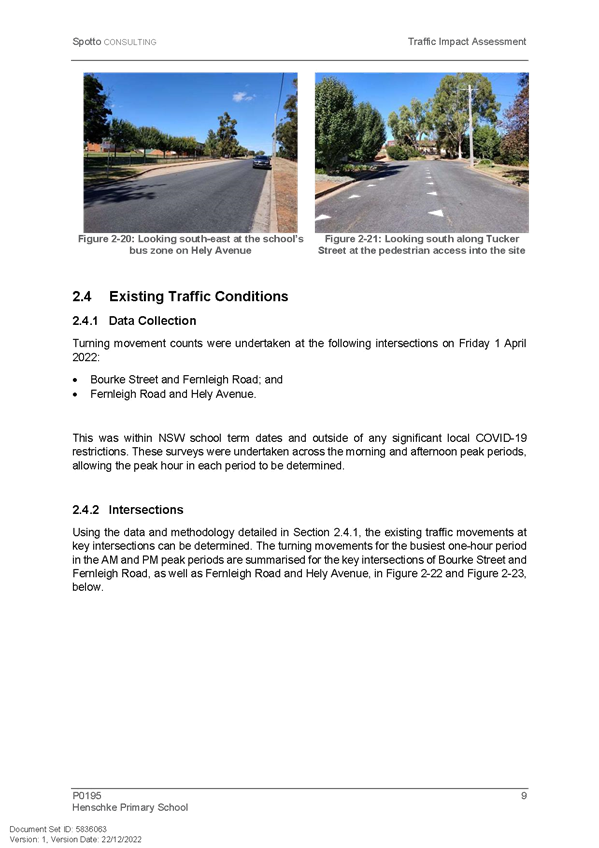
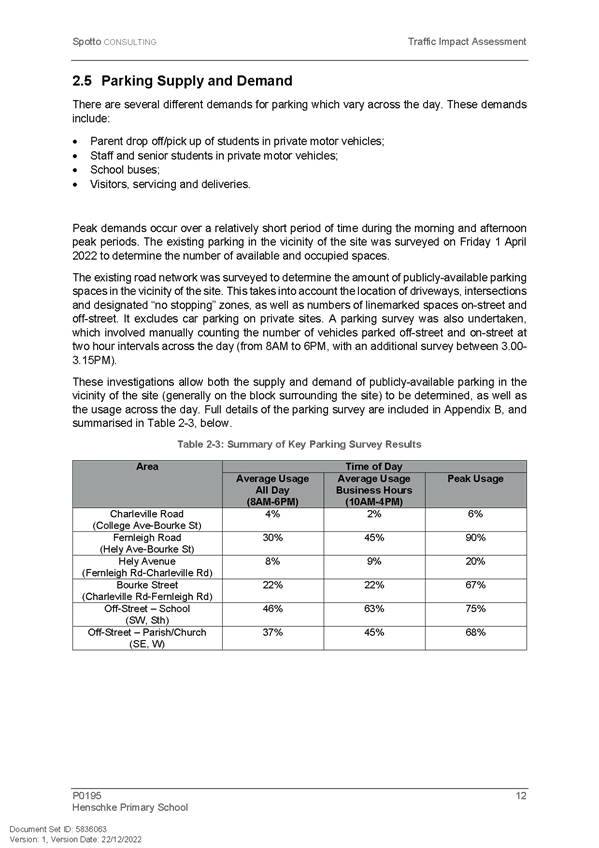
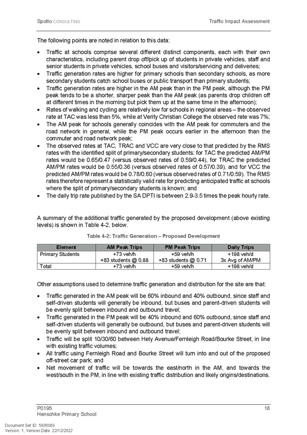
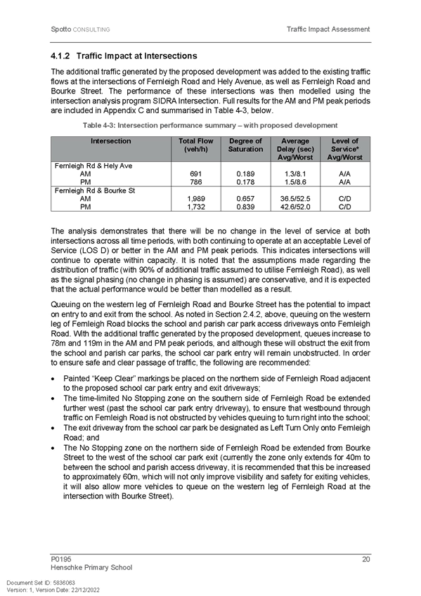
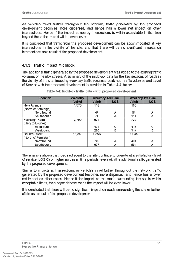
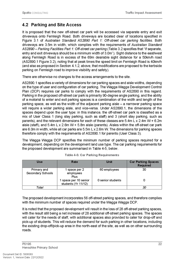
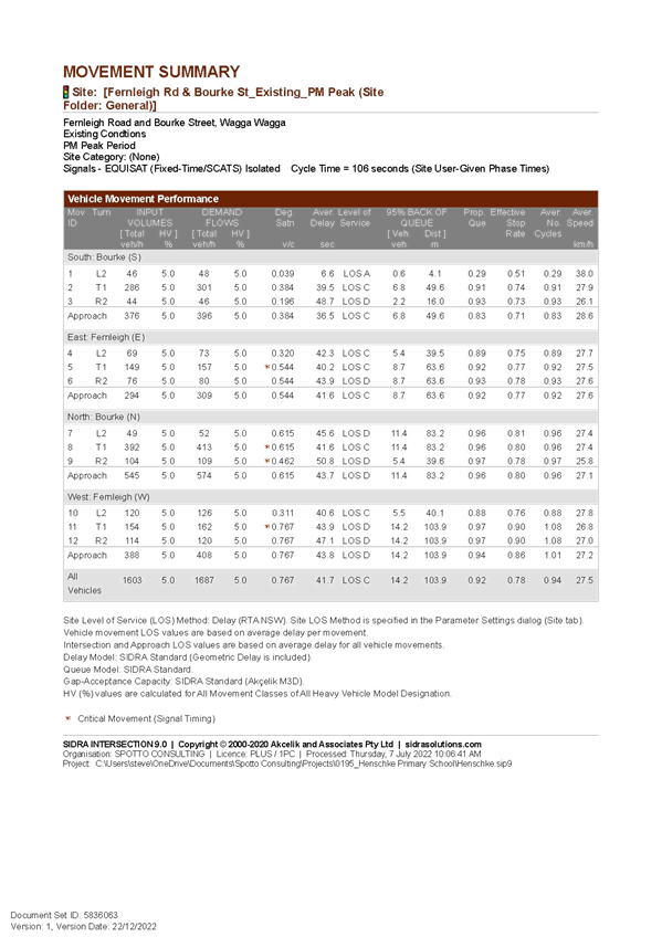
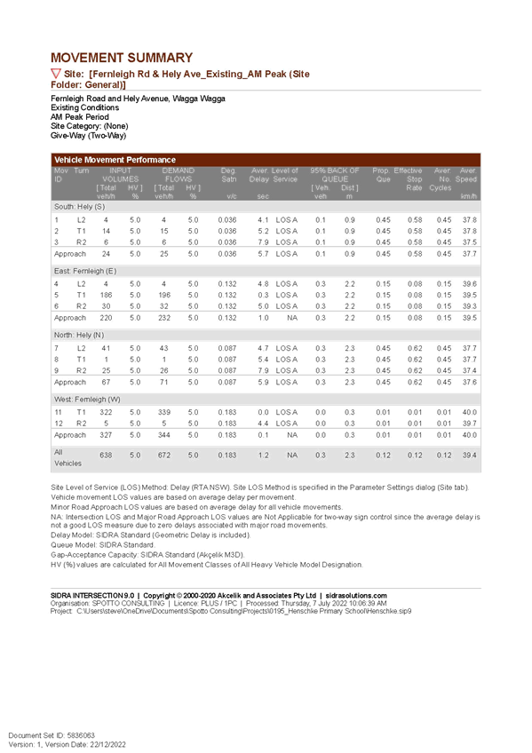
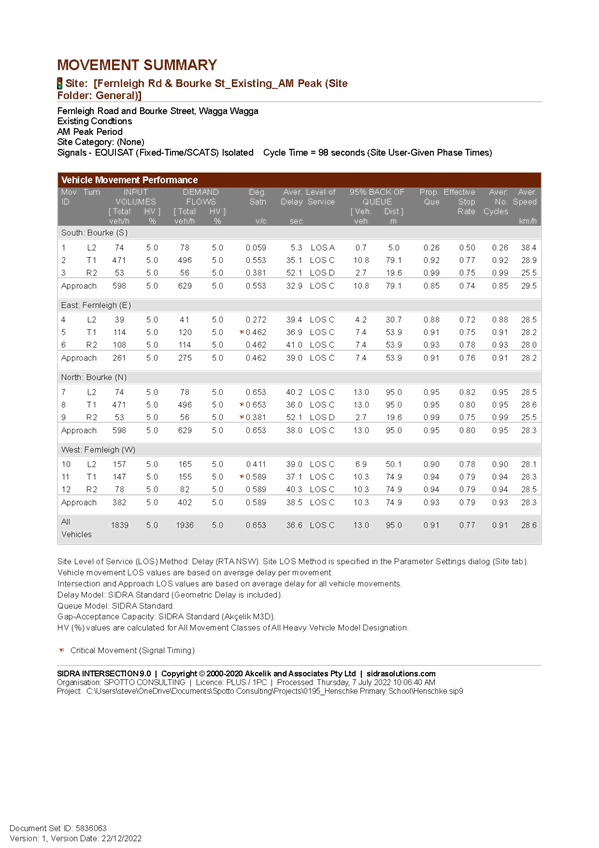
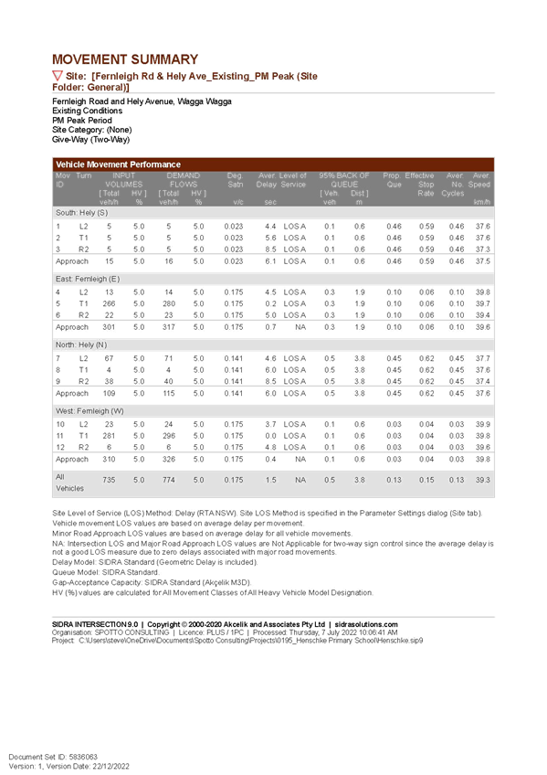
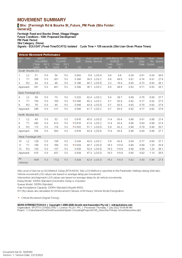
RP-2 Fernleigh Road - NO STOPPING and associated traffic controls
Author: Warren Faulkner
|
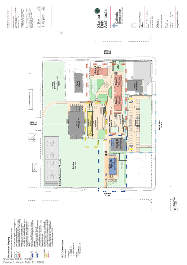
That the Local Traffic Committee approve the installation of the following traffic controls on Fernleigh Road in accordance with a notice of development consent for DA22/0787 and as per Spotto Consulting Drawing Number 0195-01 Revision B: a. a length of NO STOPPING zone on the northern side of Fernleigh Road from the intersection with Bourke Street to a point 45 metres west of the proposed exit driveway
b. a length of NO STOPPING zone on the northern side of Fernleigh Road, spanning 6 metres either side of the western most driveway entry to the new carpark
c. a length of NO STOPPING zone on the southern side of Fernleigh Road, Bourke Street to western side of the driveway at 124 Fernleigh Road
d. all signs to depict the following:
NO STOPPING 8AM – 9.30AM 2.30PM – 4PM SCHOOL DAYS
e. the words KEEP CLEAR be painted on the east bound lane of Fernleigh Road immediately outside the western driveway entry to the new carpark
f. a left turn only arrow sign be installed on the northern side of Fernleigh Road at the exit driveway from the new carpark
|
Background
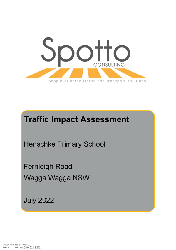
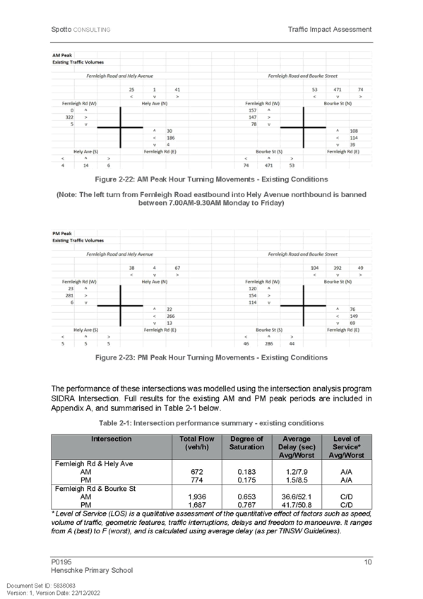
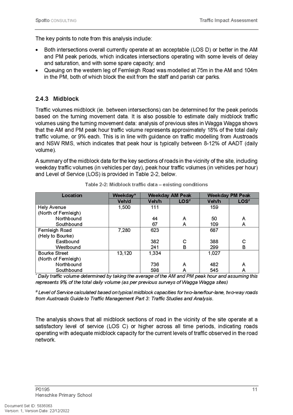
This report was deferred by the Local Traffic Committee at its 14 September 2023 meeting pending further information. The Signage and pavement marking parking that reflects the conditions of consent for the development are now attached. The Traffic Impact Assessment for the development has also been attached for the information of the Committee.
Report
A modified notice of development consent (DA22/0787.01) has been issued for the construction of a new car-park (54 spaces) with amended access arrangements to Fernleigh Road, demolition of structures, tree removal and landscaping associated with the Henschke Primary School.
Condition C.22A of the consent is:
C.22A Prior to the use/occupation of the car park, a plan shall be submitted to and approved by the General Manager or delegate, that identifies the following:
i) On the northern side of Fernleigh Road - A "No Stopping" zone shall be established during school hours from the intersection with Bourke Street to 45m west of the proposed exit driveway.
ii) On the northern side of Fernleigh Road - A "No Stopping" zone shall be established 6m either side of the (western) entry driveway to the carpark.
iii) On the southern side of Fernleigh Road. A "No Stopping" zone shall be established during school hours from the intersection with Bourke Street to western side of the driveway at 124 Fernleigh Road.
This plan is required to be referred to and approved by the Local Traffic Committee as these works incorporate a prescribed traffic control device.
The attached plan diagram depicts the proposed layout of the proposed traffic controls.
The purpose of the KEEP CLEAR is to maintain accessibility for vehicles turning right from the westbound lane and keeping that travel lane free in heavy traffic conditions.
Similarly, the LEFT TURN ONLY at the exit will facilitate free movement of traffic in one direction only to prevent vehicles turning right, which would impact on eastbound traffic flow at peak times.
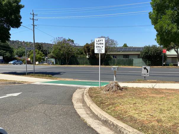
It should be noted that a LEFT TURN ONLY sign already exists at the eastern most “Existing Driveway” denoted on the Spotto Signage plan, a photo of this arrangement is as follows:
The Local Traffic Committee may want to consider the addition of “No Entry” signs from Fernleigh Road to the two Exit Driveways at the eastern end of the site to provide improved instruction for motorists intending to use the off-street car park and facilitate the free movement vehicles travelling west to the designated entry to the car park.
Risk Management Issues for Council
No risks identified for this proposal.
Internal / External Consultation
Consultation as per the development application process.
|
1⇩. |
Henschke Primary School Signage |
|
|
2⇩. |
DA22/0787 Traffic Impact Assessment |
|
|
Report submitted to the Traffic Committee on Thursday 16 November 2023 |
RP-3 |
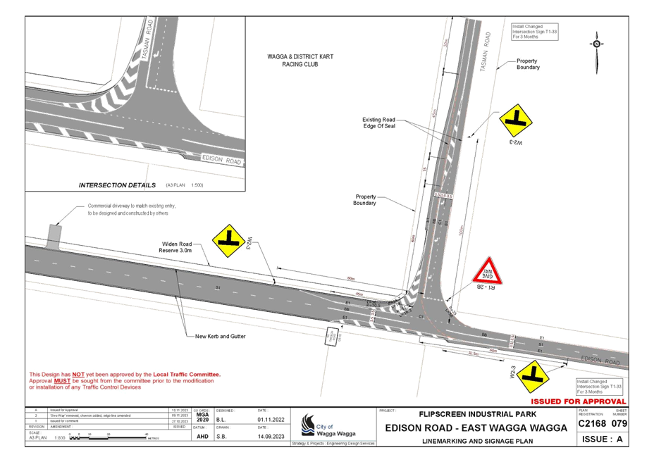
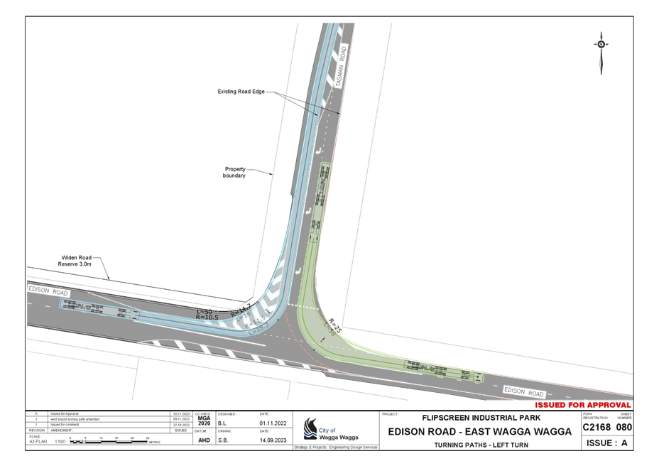
RP-3 Tasman Road / Edison Road Intersection Upgrade
Author: Bede Lane
|
That the Local Traffic Committee endorse the installation of the regulatory signs and line marking at the Intersection of Tasman Road and Edison Road, East Wagga Wagga as shown on Council Plan Registration C2168 Sheet 079 Revision A dated 10 November 2023. |
Flipscreen Australia is developing 7 industrial buildings on an existing vacant block (Lot 9 DP 846835) that fronts the unformed section of Edison Road to the west of the Tasman Road as shown on the following plan.

Condition C.50 of the development approval (DA22/0534) requires Flip-Screen to construct the unformed section of Edison Road to the west of Tasman Road including the Tasman Road intersection upgrade.
Tasman Road from Copland Street to Edison Road, and Edison Road from Tasman Road to Bakers Lane are sign posted at 80km/hr. Tasman Road and Edison Road are approved 25/26m B-Double routes.
The existing ‘intersection’ of Tasman and Edison Roads consists of a substandard curve with an operating speed of less than 40km/hr calculated in accordance with Austroads Guide to Road Design Part 3. Access to Flipscreen Industrial Park for 26m B-Double vehicles will be from the Tasman and Edison Roads intersection.
The design aspects of the intersection upgrade are:
· Road widening to provide 3.0m wide CHR(s) in Tasman Road Southbound to allow B-Double access to Flipscreen Industrial Park
· Change the priority of the existing Tasman and Edison Roads intersection to a conventional intersection with Edison Road having the priority.
· Marking of centrelines and edge lines to establish 3.5m travel lanes.
· Road widening and provision of 1.5m wide shoulder in Edison Road Westbound.
· Relocation of the existing Wagga and District Kart Racing Club access from adjacent to the Tasman Road and Edison Road intersection to Edison Road as shown on Plan ISSUE B - C2168 06.
· Installation of new intersection warning signs.
The provision of improved traffic delineation and signage at the intersection will assist in reducing vehicle operating speeds to cater for the expected increase in B-Double vehicles.
Refer to the attached Plan Registration C2168 Sheet 079 for details of the proposed line marking and signage for the revised Tasman and Edison Roads intersection treatment.
Refer to the attached Plan Registration C2168 Sheets 080 and 081 for 26m B-Double swept paths with 0.5m vehicle body allowance in accordance with Austroads (2013).
Risk Management Issues for Council
There are no risk management issues associated with this report for Council
Internal / External Consultation
External consultation has occurred with Flip-Screen Australia and the Wagga and District Kart Racing Club.
|
1⇩. |
Plan Registration C2168 - Edison/Tasman Intersection Upgrade Sign, Line Marking & Swept Path Plans |
|
|
Report submitted to the Traffic Committee on Thursday 16 November 2023 |
RP-4 |
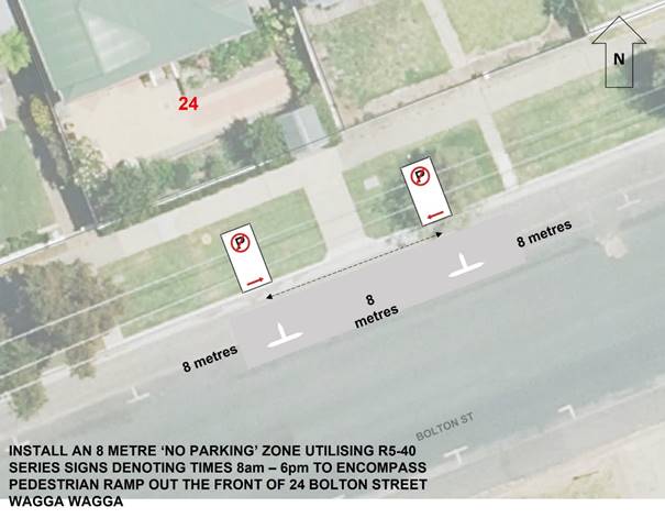
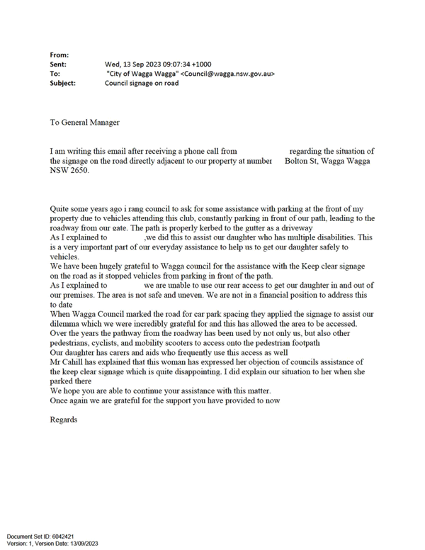
RP-4 Proposed No Parking Signs - 24 Bolton Street Wagga Wagga
Author: Warren Faulkner
|
That the Local Traffic Committee approve the installation of an 8 metre long No Parking zone centred evenly either side of the pedestrian ramp in front of 24 Bolton Street. |
Report
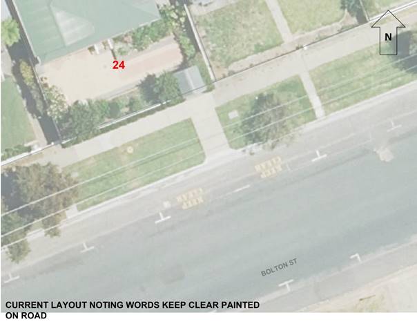
Council has previously installed informal KEEP CLEAR markings in a parallel car parking space in front of 24 Bolton Street, Wagga Wagga as shown following.
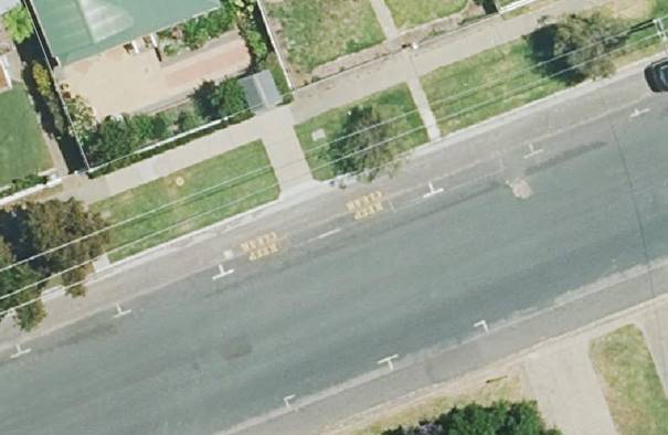
The intent of providing the KEEP CLEAR road markings in the parking bay was to provide a clear area in front of the path from 24 Bolton Street to the street, as the owners of 24 Bolton Street have a child who has multiple disabilities, thus the child could be picked-up or dropped off by vehicles at any time or also ensuring parking was available for medical support, etc.
However, as the KEEP CLEAR has never been formalised and is not able to be enforced, motorists have been parking in the bay marked KEEP CLEAR which does prevent unrestricted mobility access to and from the roadway for the disabled daughter.
The attached correspondence from the owners of 24 Bolton Street confirms their concerns.
After speaking with the property owners and noting the limitations associated with the painted ‘KEEP CLEAR’ road markings, Council officers propose to formalise a short 8 metre overall length of time restricted NO PARKING zone to encompass the pedestrian ramp out the front of 24 Bolton Street to improve access and sight distance in both directions for people using the ramp as shown following.

Additionally, the No Parking zone will allow uninhibited ability to pick up and drop off persons, including carers and Ambulances, by keeping the zone clear.
The restriction is governed by regulation 168 ‘No Parking” signs of the ROAD RULES 2014 which states that a the driver of a vehicle must not stop on a length of road or in an area to which a no parking sign applies, unless the driver dropping off, or picking up, passengers or goods, and does not leave the vehicle unattended, completes the dropping off, or picking up, of the passengers or goods, and drives on, as soon as possible and, in any case, within the required time after stopping. That time being 2 minutes or 5 minutes under rule 206 if the driver's vehicle displays a current parking permit for people with disabilities.
Given the circumstances surrounding this location, it is reasonable to consider the implementation of a length of NO PARKING zone as indicated above.
Risk Management Issues for Council
There are no significant risk issues for Council in endorsing the officers recommendation.
Internal / External Consultation
External consultation has occurred with the owners of 24 Bolton Street who are sportive of the officer’s recommendation.
|
1⇩. |
24 Bolton Street - Current Keep Clear painted markings |
|
|
2⇩. |
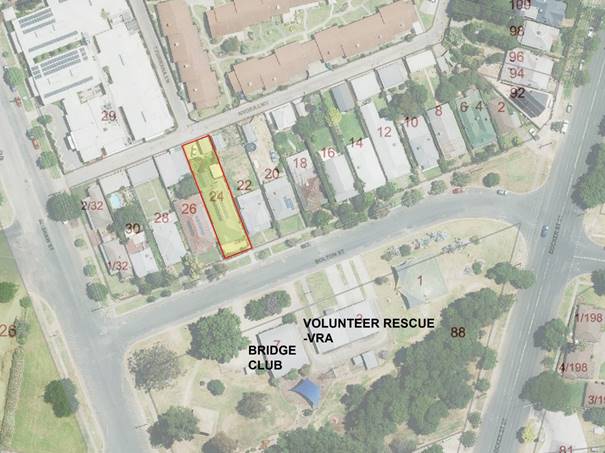
24 Bolton Street - Site Map |
|
|
3⇩. |
24 Bolton Street - Proposed No Parking Signage |
|
|
4⇩. |
Redacted Email from customer re 24 Bolton Street |
|
|
Report submitted to the Traffic Committee on Thursday 16 November 2023 |
RP-5 |
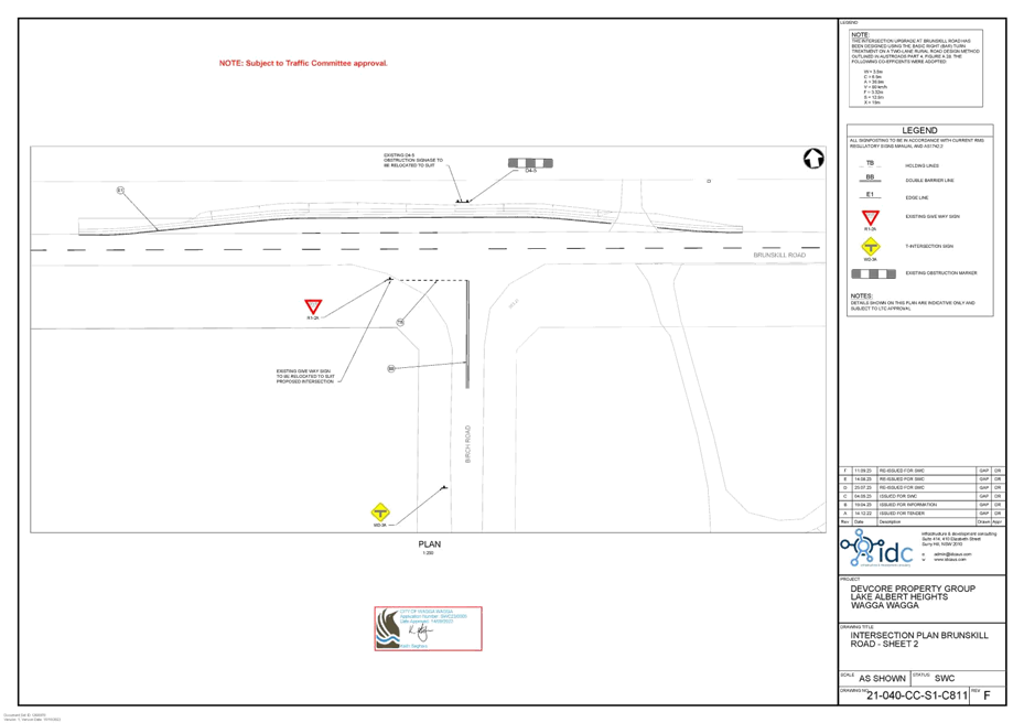
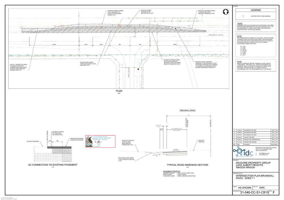
RP-5 Installation of Giveway Sign and Line Marking at the intersection of Birch Road and Brunskill Road
Author: Warren Faulkner
|
That the Local Traffic Committee endorse the installation of regulatory signs and line marking at the Brunskill Road and Birch Road intersection upgrade as per Infrastructure & Development Consulting (IDC) Drawing Number 21-040-CC-S1-C811 Revision F dated 11 September 2023. |
Report
Council has approved a Subdivision Works Certificate (SWC23/0005) that includes a plans to upgrade the Brunskill Road & Birch Road intersection in Lake Albert to include a BAR treatment in accordance with AUSTROADS standards as required by condition C.8 of the consent for DA22/0210.01
Infrastructure & Development Consulting (IDC) Drawing Number 21-040-CC-S1-C811 Revision F dated 11 September 2023 that has been stamped with the Construction Certificate has a note on it that it is “Subject to Traffic Committee approval” because it contains a regulatory R1-2A GIVE WAY sign as well as line marking.
The IDC line sign and line marking plan as well as the geometric plan detailing providing dimensions of the BAR arrangement are attached.
Construction of the BAR arrangement and installation of the signs and line marking is required prior to the release of the Subdivision Certificate for Stage 1 of the subdivision development which is known as Lake Albert Manors in behind existing dwellings on Brunskills Road and Birch Road.
Lake Albert Manors is a 131 Lot infill residential subdivision bounded by Brunskill, Birch, Silverwood and Mitchell Roads.
Risk Management Issues for Council
Not Applicable
Internal / External Consultation
The intersection design was referred to Council’s Design and Subdivision divisions for review during assessment of the Construction Certificate.
|
1⇩. |
Brunskill Road & Birch Road Intersection Upgrade Signage and Line Marking Plan |
|
|
2⇩. |
Brunskill Road & Birch Road Intersection Upgrade Geometric Plan |
|
|
Report submitted to the Traffic Committee on Thursday 16 November 2023 |
RP-6 |
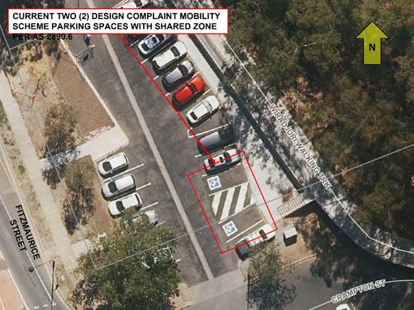
RP-6 Crampton Street Carpark - Installation of Disabled Parking Signs
Author: Warren Faulkner
|
That the Local Traffic Committee endorse the delineation of the Mobility Parking Scheme zone in the Council managed car park located on the northern side of Crampton Street immediately east of the intersection with Fitzmaurice Street, using standard R5-1-3 series “Parking – Disabled Only” signs in accordance with AS2890.6-2022 “Parking facilities – Off Street Parking for people with disabilities”. |
Report
At the 9 October Ordinary Meeting of Council, Councillor McKinnon requested Council investigate options to provide a safe pathway preventing cars from parking on the pathway in the marked exit space to the levee bank located in the Council carpark at the far end of Fitzmaurice Street, Wagga Wagga.
Upon inspection, officers have identified that the marked exit space is the ‘Shared Area’ of two current 90° front-to-kerb Mobility Parking Scheme (MPS) marked parking spaces as shown in the following photo.
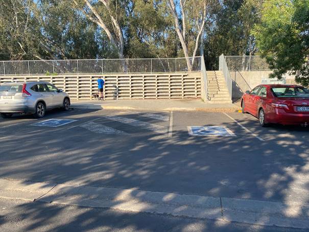
As can be seen in the photo, the MPS has not had the associated Disabled Parking signs sign posted.
The two spaces and the associated PRAM ramp and shared area are compliant in design and installation following completion of the car park in 2019 and the more recent levee bank upgrade with Australian Standard AS2890.6 relating.
It is proposed to install 2 new R5-1-3 signs and a frangible bollard as shown in the following diagram.
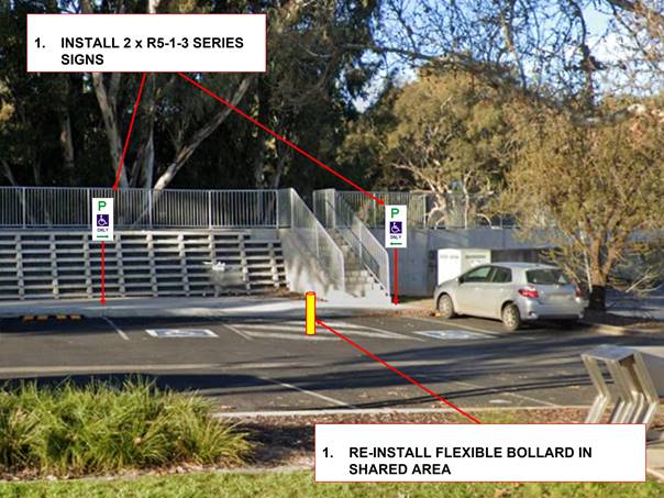
The car park being situated in proximity to the various nearby businesses, the Wiradjuri Walking Track, and the river precinct, attracts the community to the parking which includes 19 ordinary parking spaces not being limited by time.
The Mobility Parking Scheme (Disabled Parking) spaces are used regularly daily and require sign posting to legally support their intended use.
Risk Management Issues for Council
N/A
Internal / External Consultation
N/A
|
1⇩. |
Crampton Street Carpark - MPS Overview Diagram |
|
|
Report submitted to the Traffic Committee on Thursday 16 November 2023 |
RP-7 |
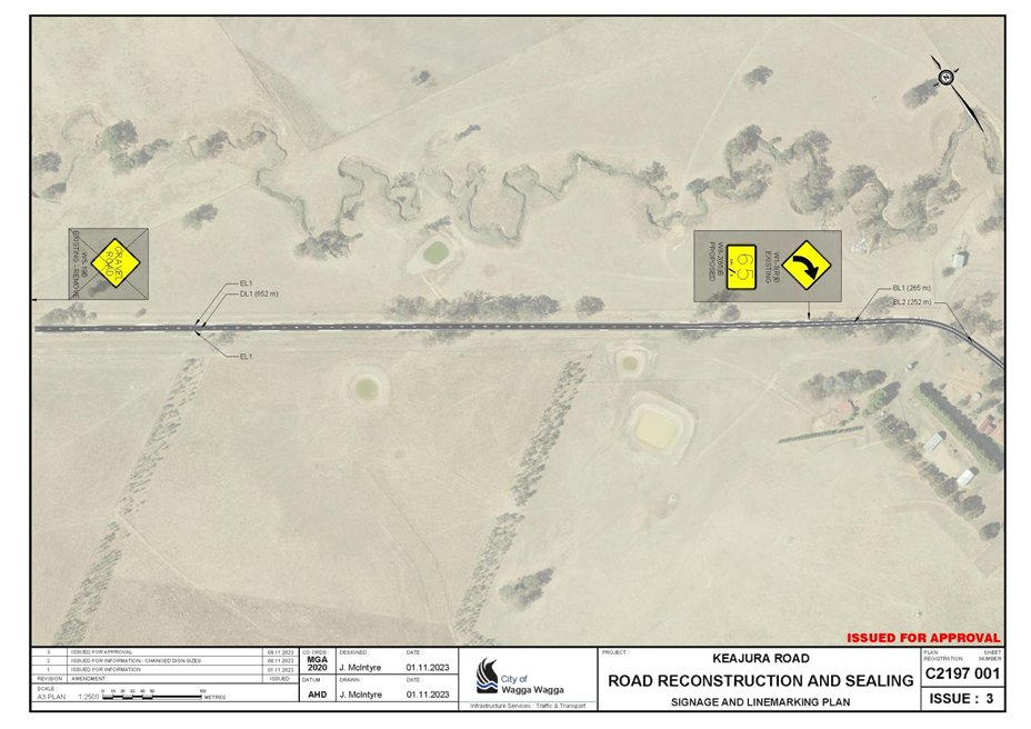
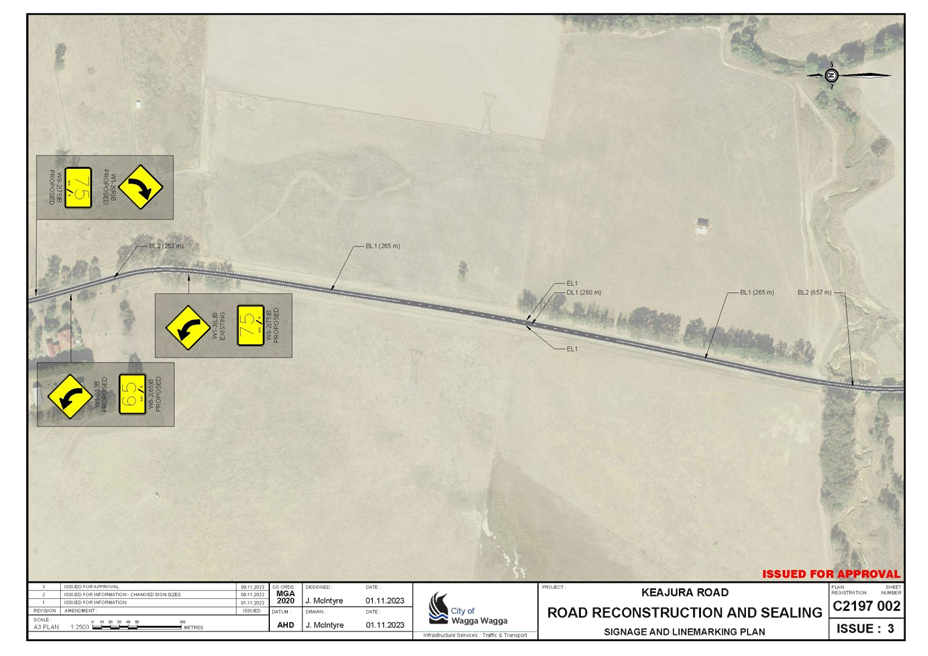
RP-7 Keajura Road - Linemarking
Author: Jack McIntyre
|
That the Local Traffic Committee endorse the installation of regulatory line making and signage on the first 2.6km of Keajura Road off the Hume Motorway as per Council Plan Registration C2197 Sheets 001 to 003 Revision 1 dated 9 November 2023. |
Report
Council is currently undertaking upgrade works on Keajura Road to seal the remaining 2600m unsealed portion of Keajura Road, leading into the Hume Highway south of Tarcutta.
Council is proposing to install signage and line marking to manage risks associated with the likely increase in vehicle speeds and volumes; from the improved road environment. The core aspects of the proposal involve:
· Marking of edge lines to establish 3.3 m travel lanes,
· Making of centre dividing lines,
· Installation of advisory speeds on existing curve warning signs,
· Installation of new curve warning signs with advisory speeds,
· Installation of chevron alignment markers at one particularly substandard curve,
· Installation of give-way warning sign on the approach to the Hume Highway intersection,
· Removal of gravel road signage at each end of the project.
The proposed traffic controls will work together with other hazard reduction measured being completed as part of the project, including removal of hazardous trees and installation of guardrail where hazards cannot be removed.
Risk Management Issues for Council
Manage road safety through appropriate and complaint traffic controls
Internal / External Consultation
N/A
|
1⇩. |
Plan Registration C2197 Sheets 001 to 003 Keajura Road Signage and Linemarking Plans |
|
|
Report submitted to the Traffic Committee on Thursday 16 November 2023 |
RP-8 |
RP-8 Proposed Linemarking for various existing roundabouts
Author: Warren Faulkner
|
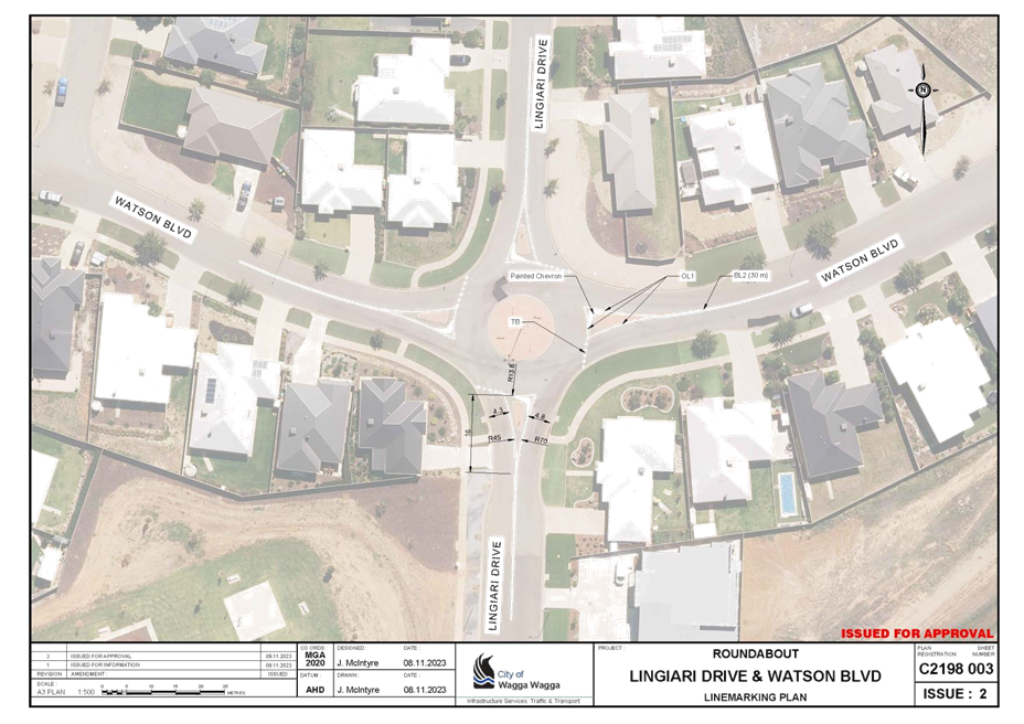
That the Local Traffic Committee endorse the installation of: a regulatory signage and line marking at the Muttama Parade/Ross Parkway roundabout, Gobbagombalin as per Council Plan Registration C2198 Sheet 001 Revision 2 dated 9 November 2023. b line marking at the Messenger Avenue/Bradman Drive roundabout, Boorooma as per Council Plan Registration C2198 Sheet 002 Revision 2 dated 9 November 2023. c line marking at the Watson Boulevard/Lingiari Drive roundabout, Lloyd as per Council Plan Registration C2198 Sheet 003 Revision 2 dated 9 November 2023.
|
Report
The roundabouts at the Muttama Parade and Ross Parkway intersection in Gobbagombalin, Messenger Avenue and Bradman Drive intersection in Boorooma and the Watson Boulevarde and Lingiari Drive intersection in Lloyd do not have any line marking present.
There are no R1-3 ROUNDABOUT GIVEWAY signs on any of the four corners as well as R2-3 KEEP LEFT signs on all four splitter islands at the Muttama Parade/Ross Parkway roundabout. These sigs are present at the Messenger Avenue/Bradman Drive and Watson Boulevarde/Lingiari Drive roundabouts.
The attached plans propose full line marking of these roundabouts in line with Austroads guidelines. It is also proposed to install R1-3 (roundabout give-way) signs and R2-3 (keep left) signs at Muttama Parade/Parkway roundabout.
Risk Management Issues for Council
Improve safety of road facility through improved delineation.
Internal / External Consultation
N/A
|
1⇩. |
Plan Registration C2198 Sheets 001 to 003 Roundabout Signage & Line Marking Plans |
|
Author: Warren Faulkner
|
That the Local Traffic Committee endorse the schedule of meeting dates for the next 12 months as outlined in the report. |
Report
A forward meeting plan, including bi-monthly meeting dates, is agreed by the Committee each year. At least five meetings dates are proposed each calendar year.
The Committee are advised the 2024 Local Government (General) Election will be held on 14 September 2024, resulting in the Councillor membership ceasing at midnight on 13 September 2024.
The new Council will consider its committee structure within the first few months of the Council term, with Council to consider its representation on the Local Traffic Committee, including membership by either a Councillor or Council Officer. It is anticipated that Council will adopt its position including Council member appointment prior to the proposed 14 November 2024 meeting, to ensure continuity of the Committee.
The following schedule of meeting dates is proposed for the next twelve months for the Committee’s consideration and endorsement:
|
LTC Meeting Date |
Targeted Council Meeting |
|
(Time & Place) |
(Date for Consideration) |
|
Thursday 8 February 2024 |
26 February 2024 |
|
9:00am, Civic Centre Wedge Room |
|
|
Thursday 11 April 2024 |
29 April 2024 |
|
9:00am, Civic Centre Wedge Room |
|
|
Thursday 13 June 2024 |
22 July 2024 |
|
9:00am, Civic Centre Wedge Room |
|
|
Thursday 26 August 2024 |
26 August 2024 |
|
9:00am, Civic Centre Wedge Room |
|
|
Thursday 14 November 2024 |
16 December 2024 |
|
9:00am, Civic Centre Wedge Room |
|
For the information of the Committee, Extraordinary meetings may be held from time to time to action urgent or specific items. These meetings may be undertaken as E-meetings if required.
Risk Management Issues for Council
Not Applicable
Internal / External Consultation
Internal Consultation with Councils Governance Division.