|
Report
submitted to the Floodplain
Risk Management Advisory Committee
on Wednesday 15 May 2024
|
RP-1
|
Reports from Staff
RP-1 2018-19-FM-0071 - North Wagga Flood Mitigation
Options
Author: Andrew
Mason
Director: Phil
McMurray
|
Summary:
|
The project
has reached finalisation and the consultant is presenting the final report
and recommendations for adoption.
|
|
That the
Floodplain Risk Management Advisory Committee receive and note the final report
and recommends to the Council that it receive and adopt the report and the
recommendations in full.
|
As per the
scope and brief of this study the consultant CIE, Woolcott, WMAwater and NGH
have completed the four key areas of analysis:
· Economic
· Environmental
· Social
· Cultural
In discussion
with this committee, the final report has been developed to reflect the
findings of this analysis and has the following conclusion for Flood Mitigation
for North Wagga:
Of the different options that could be
adopted:
– The combined L4A with a
targeted VHR/VHP to high risk residents outside North Wagga delivers the best
outcome for the community. However, there may be challenges for some households
due to accessibility issues which could result in additional costs above the
assumed $120,000/property raising.
– L4B by itself or in
combination with any other strategies is too expensive to be cost effective,
regardless of the size of potential benefits.
– VHR and VHP delivers positive
outcomes for the community where it is applied to high risk properties where
the risk reduction is greater than the cost of the actions. This suggests a
strategic approach to the application of these policies based on estimated risk
reduction. Further, the VHP policy could be more efficient where the purchase
applies only after flooding. A pre-emptive policy would immediately
“destroy” the value of the property with certainty, compared to the
comparatively low probability of this. An alternative would be to purchase a
property pre-emptively but maintain it as part of the housing stock until it is
damaged by a flood event which could be in, say, 10 years’ time.
In implementing the proposed levee it
is important to recognise that water is diverted to other parts of the
floodplain, potentially negatively impacting on some properties. However, where
negative impacts occur these are typically only result in minor increases flood
depths. The risk reduction benefits of the levee substantially outweighs the
potential negative impacts on some properties.
Based on the draft report the FRMC had
developed the following likely recommendation for Council:
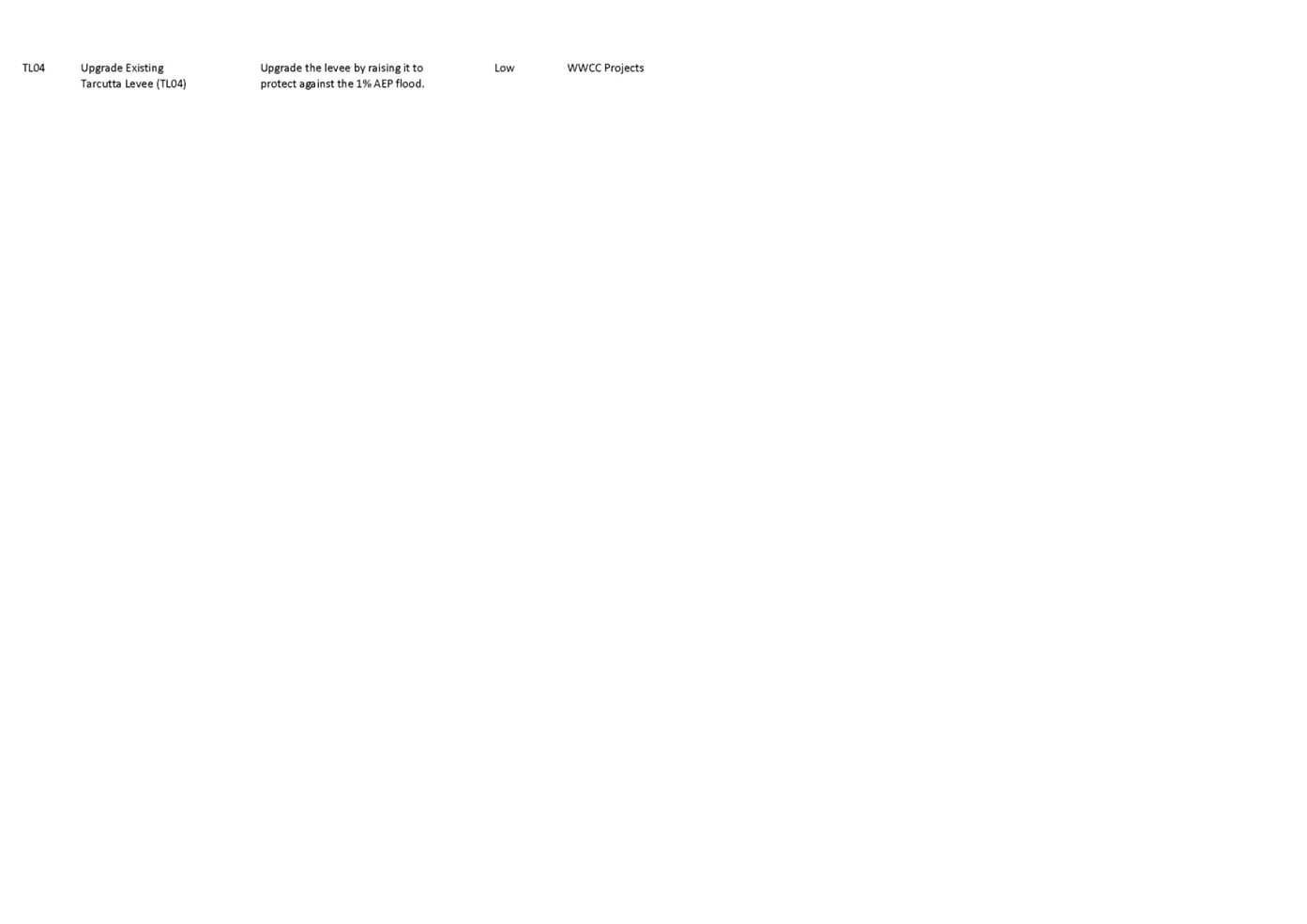
a. Upgrading
the existing North Wagga Levee system (Stage 1 of L4B - 5% AEP (1 in 20)) and
offering Voluntary House Raising and Purchase subject to risk reduction and
cost effectiveness
b. Increasing the road heights and
bridges along Hampden Ave to provide a safe evacuation route (Stage 2 of Option
L4B) subject to funding.
Public
Exhibition
Public exhibition
of the Flood Mitigations Options for North Wagga was required by the Local
Government Act (1993, Section 38). This section stipulates that Council must
exhibit the draft plan for public comment for a period of at least 28 days, and
that submissions must be considered by the council before the plan is endorsed
or amended.
The Draft
Report was endorsed for public exhibition at the Council meeting on the 11
March 2024. The Public Exhibition period commenced on the 15 March 2024 and was
closed on the 26 April 2024, after a period of 42 days.
Digital copies
of the report were available on the Council website through the “Have
Your Say” page and one on one sessions with Council Officers were
available to be booked through this page.
The Reports, as attached, were presented
for public exhibition, and included:
· Flood
Mitigation Options for Wagga Wagga, Evaluation of options (CIE, Feb 2024)
· Flood Mitigation
Options for Wagga Wagga, Evaluation of options (CIE, Oct 2023)
· North Wagga Flood
Mitigation Community Engagement Report Phase 2 (Woolcott Research, 2024)
· North Wagga Flood
Risk Mitigation Community and stakeholder Engagement Study (Woolcott Research,
2023)
· Assessment
of Environmental Constraints North Wagga Flood Mitigation Options (NGH, 2023)
· Biodiversity
Assessment Report North Wagga Flood Levee (NGH, 2023)
· Flood Impacts of
Flood Mitigation Options for North Wagga (WMA Water, 2024)
There were six
submissions received from the public and one from Biodiversity Conservation and
Science during the PE period and an outline of these is included as an
attachment to the final report.
The three
submissions and the three one on one meetings did not highlight any significant
problems or concerns with the proposed mitigation options.
The
submission from Biodiversity Conservation and Science stated:
BCS has reviewed the Biodiversity
Assessment Report North Wagga Flood Levee (NGH 2023). We agree the proposed
works are likely to cause significant impact on threatened species. While that
impact is likely to vary depending on the option(s) that are eventually built,
we consider it important to determine the precise nature of that impact per
option, and to use that information iteratively to avoid and minimise harm to
biodiversity.
Given significant impact is likely,
section 7.12(3) of the Biodiversity Conservation Act 2016 establishes Council
is not to give consent without either the concurrence of the Environment Agency
Head or a Biodiversity Assessment Development Report (BDAR). The review of
environmental factors (REF) established by Part 8 of the Environmental Planning
and Assessment Regulation 2021 is a good opportunity for Council to decide
which of those two pathways best suit the activity. Given the proposed activity
involves various options, we strongly recommend a BDAR is the best approach.
The BDAR relies on a method that will
determine which option best avoids and minimises harm, mitigation measures that
can be applied locally to maintain habitats and populations in situ, and price
offsets per option to inform Council’s decision. The BDAR will also rely
on the Biodiversity Offset Scheme to mitigate harm. That approach means Council
does not have the ongoing burden of managing offset work.
The initial
information Council has is that a BDAR will take 15-18 months to complete and
has a cost of approximately $100,000.
Implementation timeline for
adopted recommendation
|
Stage
|
Duration
|
Commencement
|
|
Topographic Survey
|
6 months
|
August 2024
|
|
Voluntary House Raising (VHR) and Voluntary House
Purchase (VHP) project development and implementation
|
3-5 years
|
January 2025
|
|
Environmental Assessment
|
18 months
|
September 2024
|
|
Civil Design
|
12-15 months
|
July 2025
|
|
Levee contractor procurement
|
4 months
|
November 2026
|
|
Levee construction
|
24 months
|
March 2027
|
There are some
significant issues that the committee need to be aware of regarding the
recommendations from this report.
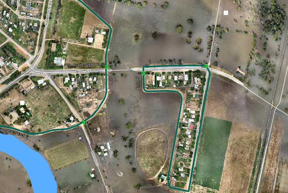
Evacuation
Level for North Wagga
With the
existing levee in place, the current evacuation trigger for North Wagga is a
river height of 9.3m. The existing road network around North Wagga is inundated
at a river height of approximately 9.4m. The “banks” along Hampden
Ave between the Wiradjuri Bridge and Parken Pregan Bridge adjacent to Wilks
Park are not keyed into the underlying ground and cannot be assumed to offer a
safe evacuation route beyond the existing 9.3m. The Mill St causeway between
East St and the Marah St is inundated at 9.4m and the East St section of North
Wagga becomes isolated beyond this river height.
If a 10.1m
levee plus freeboard is constructed around North Wagga and the existing road
network or the “banks” are not modified then the evacuation trigger
for North Wagga will probably remain at 9.3m.
The NSW State
Emergency Service have been consulted regarding this issue and have provided
the following response:
The NSW SES
further recommend:
· Continuing to
progress flood mitigation and management options in accordance with the NSW
Flood Prone Land policy as set out in the Flood Risk Management Manual 2023
(the Manual) and supporting guidelines. This would include a detailed
assessment during the next phase of the mitigation process to understand flood
behaviour and constraints.
· Investigating ways
to improve emergency access and egress during a flood.
· Carefully
considering any locations of proposed increase in density of development and
its associated increased risk to life and property. This flood mitigation
option will address some residual risk to life and property.
· Considering
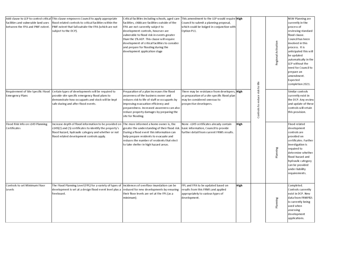
Development Control Plan 2010 (DCP) which strengthen the land use planning
process to identify areas where risk to life from flooding is intolerable.
The second
point in the above extract may allow Council to investigate the formalisation
of the Wilks Park banks to enable the construction of similarly sized banks to
a suitable standard to allow them to be licenced as levees and potentially for
the SES and Council to raise the evacuation trigger for North Wagga to a level
closer to the design height of the new levee.

The secondary
issue with evacuation and egress is that the residents along East St will
possibly still have to evacuate at 9.3m. Mill St between East St and the ring
levee becomes inundated at around 9.3m - 9.4m.
There is no
simple infrastructure solution to this and it may require the new levee design
to incorporate a helicopter rescue pad into the East St levee for emergency
evacuations.

If the banks
along Wilks Park are formalised, the section of North Wagga protected by the
ring levee will still be able to evacuate at 9.7m while the section of North
Wagga along East St will need to evacuate at approximately around 9.3m.
Newly
Inundated Houses
If a 5% AEP
levee is constructed around North Wagga without the excavation to offset the
displacement of water, there will be adverse effects to over 1100 other houses.
In a larger flood event (1 in 200, 1 in 500) when the main city levee is
overtopped there will be increased water in a significant number of houses.
These houses already have over floor flooding but will have an increased amount
of water of up to 200mm flowing through them.
There are a few
properties that will now be flood affected that weren’t previously
inundated around East Wagga in a 5% AEP. Those 25 properties will be part of
the targeted VHR/VHP program.
Funding
· Council has $6.3M
in funding raised through the levee Special Rate Variation (SRV)
· Council has $1M
available through the CDG0789 grant, this must be expended by December 2025
· Council has
applied for the next round of BCS DCCEEW Floodplain grants for $5M to
allow for the environmental analysis, detailed design and construction of the
North Wagga levee system
· Council has
applied for the next round of BCS DCCEEW Floodplain grants for a VHP and VHR
feasibility Scoping Study for the 25 houses that will be adversely affected by
the construction of Stage 1 of the Flood mitigation options for North Wagga.
This final
report is being presented to the committee for acceptance and the committee is
required to recommend to Council that it receive the report and accept the
recommendations in full. A detailed report will then be presented for
consideration at the Council meeting on 27 May 2024.
N/A
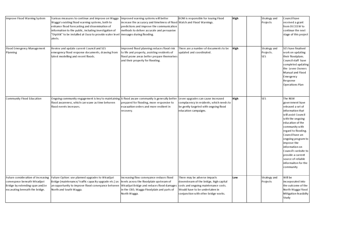
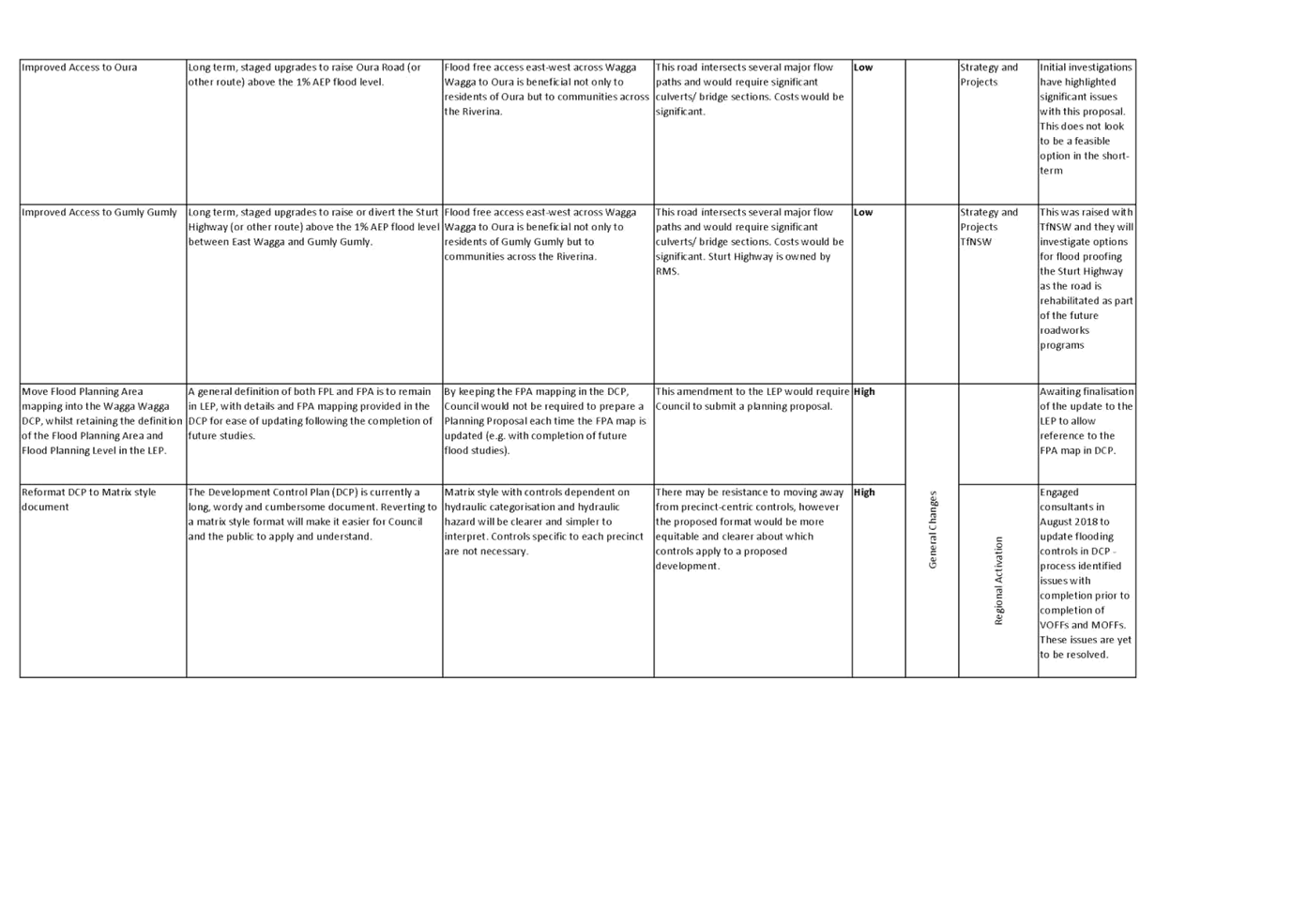
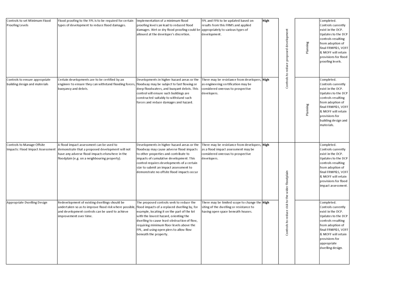
Local Government Act
Development Control Plan 2010
Flood Risk Management Manual
Safe and Healthy Community
Objective: Our community feel safe
Be responsive to emergencies
Risk Management Issues for
Council
N/A
Internal / External
Consultation
The Committee
are advised that the consultants will attending this meeting remotely and
presenting via zoom.
|
1.
|
CIE Report_Wagga Wagga CC_Flood Mitigation Options -
Provided under separate cover
|
|