Agenda
and
Business Paper
To be held on
Monday 11
October 2021
at 6.00pm
Civic Centre cnr Baylis and Morrow Streets,
Wagga Wagga NSW 2650 (PO Box 20)
P 1300 292 442
P council@wagga.nsw.gov.au
wagga.nsw.gov.au
Agenda
and
Business Paper
To be held on
Monday 11
October 2021
at 6.00pm
Civic Centre cnr Baylis and Morrow Streets,
Wagga Wagga NSW 2650 (PO Box 20)
P 1300 292 442
P council@wagga.nsw.gov.au
wagga.nsw.gov.au
NOTICE OF MEETING
In pursuance of the provisions of the Local Government Act, 1993 and the Regulations there under, notice is hereby given that an Ordinary Meeting of the Council of the City of Wagga Wagga will be held in the Council Chamber, Civic Centre, Corner Baylis and Morrow Streets, Wagga Wagga, on Monday 11 October 2021 at 6.00pm.
Council live streams video and audio of Council meetings. Members of the public are advised that their voice and/or image may form part of the webcast.

Mr Peter Thompson
General Manager
WAGGA WAGGA CITY COUNCILLORS
|
Mayor Councillor Greg Conkey OAM |
Deputy Mayor Councillor Dallas Tout |
Councillor Yvonne Braid |
|
|
|
|
|
|
QUORUM
The quorum for a meeting of the Council is a majority of the Councillors of the Council who hold office for the time being who are eligible to vote at the meeting.
COUNCIL MEETING ROOM
Reports submitted to the Ordinary Meeting of Council to be held on Monday 11 October 2021.
Ordinary Meeting of Council AGENDA AND BUSINESS PAPER
Monday 11 October 2021
CLAUSE PRECIS PAGE
PRAYER 2
ACKNOWLEDGEMENT OF COUNTRY 2
APOLOGIES 2
Confirmation of Minutes
CM-1 Ordinary Council Meeting - 27 September 2021 2
DECLARATIONS OF INTEREST 2
Reports from Staff
RP-1 PLANNING PROPOSAL (LEP20/0006) TO AMEND WAGGA WAGGA LOCAL ENVIRONMENTAL PLAN 2010 LAND ZONING AND MINIMUM LOT SIZE FOR LAND LOCATED IN SPRINGVALE 4
RP-2 Planning Proposal (LEP21/0001) 456 and 474 Plumpton Road, Rowan - Amendment to land zoning, minimum lot size and urban release area provisions of the Wagga Wagga Local Environmental Plan 2010 15
RP-3 Northern Growth Area Infrastructure and Contributions 29
RP-4 Transgrid Humelink - Community Consultative Group Representative Nomination 54
RP-5 Community@Work Program - Request for Additional Funding 56
RP-6 Child Safe Policy 67
RP-7 DISCLOSURE OF PECUNIARY INTEREST RETURNS - COUNCILLORS AND DESIGNATED STAFF 2021 81
RP-8 RESPONSE TO QUESTIONS/BUSINESS WITH NOTICE 84
QUESTIONS/BUSINESS WITH NOTICE 86
Confidential Reports
CONF-1 RFT2021-25 THE GAP AND UMBANGO RURAL FIRE SHEDS 87
CONF-2 COVID-19 RENTAL RELIEF - COMMERCIAL & AIRPORT LEASES 88
CONF-3 COMMUNITY TENANT ABATEMENTS 89
PRAYER
Almighty God,
Help protect our Mayor, elected Councillors and staff.
Help Councillors to govern with justice, integrity, and respect for equality, to preserve rights and liberties, to be guided by wisdom when making decisions and settling priorities, and not least of all to preserve harmony.
Amen.
Wagga Wagga City Council acknowledges the traditional custodians of the land, the Wiradjuri people, and pays respect to Elders past, present and future and extends our respect to all First Nations Peoples in Wagga Wagga.
We recognise and respect their cultural heritage, beliefs and continuing connection with the land and rivers. We also recognise the resilience, strength and pride of the Wiradjuri and First Nations communities
CM-1 Ordinary Council Meeting - 27 September 2021
|
That the Minutes of the proceedings of the Ordinary Council Meeting held on 27 September 2021 be confirmed as a true and accurate record.
|
|
1⇩. |
Minutes - 27 September 2021 |
90 |
|
Report submitted to the Ordinary Meeting of Council on Monday 11 October 2021 |
RP-1 |
RP-1 PLANNING PROPOSAL (LEP20/0006) TO AMEND WAGGA WAGGA LOCAL ENVIRONMENTAL PLAN 2010 LAND ZONING AND MINIMUM LOT SIZE FOR LAND LOCATED IN SPRINGVALE
Author: Crystal Atkinson
Director: Michael Keys
|
At the Ordinary Meeting of Council on 22 March 2021, Council resolved to support a planning proposal and seek Gateway Determination from NSW Department of Planning, Industry and Environment.
The planning proposal sought to amend land zoning and minimum lot size provisions for land located in Springvale.
Council received a Gateway Determination from the NSW Department of Planning, Industry and Environment on 24 May 2021 to proceed with the above-mentioned planning proposal subject to extending the minimum lot size area, public exhibition, and agency consultation.
The planning proposal was placed on public exhibition from 9 August to 19 September 2021 (inclusive).
The purpose of this report is to provide feedback on the public consultation and submissions received. The report also requests adoption and gazettal of the amendment to the Wagga Wagga Local Environmental Plan 2010. |
|
Recommendation That Council: a note the results of the exhibition period for planning proposal LEP20/0006 b adopt planning proposal LEP20/0006 (as exhibited) to amend the Wagga Wagga Local Environmental Plan 2010 c request the NSW Department of Planning, Industry and Environment to prepare the amending instrument d gazette the plan and notify NSW Department of Planning, Industry and Environment of the decision |
Planning Proposal Details
|
Submitted Proposal: |
Council is in receipt of a planning proposal (LEP20/0006) to rezone land at 39 Currawang Drive, Springvale from RU1 Primary Production to R5 Large Lot Residential and reduce the minimum lot size provisions from 200 hectares to 2 hectares. |
|
Council Revisions |
An assessment of the large lot residential precinct north of Dunns Road where an 8 hectare minimum lot size provision applies showed the lot size to be predominantly 2 hectares and the formal change to 2 hectare lot size was applied to this precinct. |
|
Gateway Revisions |
The Gateway Determination was issued on 24 May 2021 and conditioned the extension of the changes to minimum lot size provisions to apply to land south of Dunns Road and east of Holbrook Road. |
|
Applicant: |
Aaron De Jong |
|
Landowner: |
Refer to confidential attachment. |
Proposal
Council is in receipt of an application to amend the Wagga Wagga Local Environmental Plan 2010 (LEP) to:
1. Rezone land from RU1 Primary Production to R5 Large Lot Residential
2. Reduce the minimum lot size from 200 hectares to 2 hectares
The purpose of the planning proposal is to provide subdivision opportunities for land adjoining an existing large lot residential area. The land is located directly west of the Springvale large lot residential area and is currently zoned RU1 Primary Production and used for agricultural purposes.
Based on the existing lot pattern, available services and character of the area, the application of the 2 hectare minimum lot size was expanded and will acknowledge the existing lot size pattern and not result in significant changes to the existing lot pattern.
The proposed amendments, as exhibited, are shown in Figures 1 and 2.
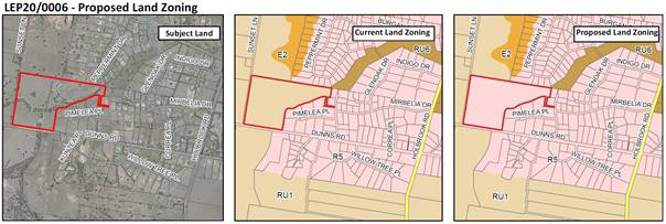
Figure 1: Proposed amendment to Land Zoning map
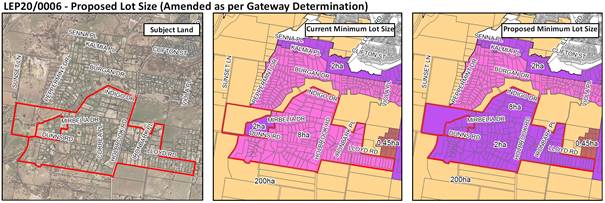
Figure 2: Proposed amendments to the Minimum Lot Size map
Site and Locality
The site is located on the southern fringe of the City around Dunns, Lloyd, and Holbrook Roads.
Gateway Determination
The NSW Department of Planning, Industry and Environment issued a Gateway Determination on 24 May 2021 for the planning proposal subject to extending the minimum lot size area, public exhibition, and agency consultation. A copy of the Gateway Determination is provided as Attachment 3.
Public Exhibition and Agency Consultation
The planning proposal and accompanying exhibition material were placed on public exhibition from 9 August to 19 September 2021 (inclusive) and agency referrals were provided to NSW department of Primary Industries, Department of Planning, Industry and Environment – Environment, Energy and Science division and NSW Rural Fire Services as per Gateway Condition No. 4. See full details below under Internal / External Consultation.
During the exhibition period, eight submissions were received, including three from agencies. A summary of the key issues raised in submissions and a response is provided under Internal / External Consultation section below.
Financial Implications
The application was submitted in the 2019/20 financial year and attracted an application fee of $40,000.00 in accordance the then Council’s Fees and Charges.
Policy and Legislation
Environmental Planning and Assessment Act 1979
Wagga Wagga Local Environmental Plan 2010
Link to Strategic Plan
The Environment
Objective: We plan for the growth of the city
Outcome: We have sustainable urban development
Risk Management Issues for Council
Changes to planning provisions present risk issues for Council, including impacts of development on the environment, community, and infrastructure. The potential impacts from this development across these issues is minor due to existing development patterns, local services, and current infrastructure capacity.
The planning proposal process requires consultation and engagement with affected property owners and wider community. This has been undertaken in accordance with Council’s local provisions, regulations, and directions from DPiE in the Gateway Determination.
Internal / External Consultation
The planning proposal was placed on public exhibition between 9 August and 19 September 2021 (inclusive) with engagement as per the table below:
|
|
|
Media |
Community Engagement |
Digital |
|||||||||||||
|
Rates notices insert |
Direct mail |
Letterbox drop |
Council news story |
Council News advert |
Media releases |
TV/radio advertising |
One-on-one meetings |
Your Say website |
Community meetings |
Stakeholder workshops |
Drop-in sessions |
Surveys and feedback forms |
Social media |
Email newsletters |
Website |
Digital advertising |
|
|
TIER |
|||||||||||||||||
|
Consult |
|
x |
|
|
x |
|
|
x |
|
|
|
x |
x |
|
|||
The planning proposal and accompanying exhibition material were made available for viewing by the public on Council’s website and at Council’s Customer Service Counter in the Civic Centre.
During the public exhibition period, eight submissions were received. The submissions are provided as Attachment 4.
A summary of the submissions and Council Officer response is provided below:
|
No. |
Submission |
Officer Response |
|
1
|
NSW Department of Planning, Industry and Environment – Biodiversity and Conservation Division § The Initial Biodiversity Assessment (NGH 2020) does not demonstrate whether the proposal exceeds the Biodiversity Offset Scheme entry thresholds, however, it does provide an important basis for more detailed assessment including a Biodiversity Development Assessment Report (BDAR).
§ Two proposed designs have been assessed by NGH Consulting. Clearing that is ancillary to developments on building envelopes, access (including upgrades to Dunns Road), services and asset protection zones is anticipated. All anticipated ancillary clearing should be included in the assessment.
§ Advise Council to seek evidence about how retained vegetation will be managed and maintained. The indirect impacts of the proposed clearing and future management of these retained areas must be assessed to ensure the long-term viability.
§ Encourage Council to consider any potential adverse impacts of the proposed development on terrestrial, aquatic, and riparian habitats and ecosystems in accordance with Clause 7.3 and 7.5 of the Wagga Wagga LEP prior to granting development consent.
§ Any potential impacts should be designed to protect or improve biodiversity values identified within the subject land.
§ Council may not consent to the proposal without being satisfied that no harm to threatened species will occur.
§ The applicant should provide a BDAR at the planning proposal stage to assess the impact. Alternatively, Council has a duty to assess the clearing ancillary to each of the anticipated development applications (DA). Every subsequent DA for the subdivision must be accompanied by a BMAT report and Test of Significance, and potentially a BDAR.
§ Encourage Council and the applicant to investigate strategic measures that mitigate the anticipated harm to threatened species. The land has the potential to improve habitat function to an extent that may mitigate the anticipated impacts. A Biodiversity Certification Assessment Report (BCAR) will demonstrate that potential.
§ Council may achieve a similar benefit by establishing planning controls and permits to protect vegetation. Examples include establishing environmental zones, positive covenants and specific controls in the Wagga Wagga DCP to limit clearing. Recommend Council condition the 16 new titles to maintain and enhance biodiversity values, including protection of the retained vegetation, cat curfews and requiring local native species to be used in all landscaping and street plantings.
§ The design of the subdivision needs to be compatible with the flood risks and not exacerbate flooding downstream. Measures include the retention of riparian corridors, buffer zones around known flow paths, and land use zoning that limits development in flow paths and riparian corridors.
§ Consider the elements of the proposal that are inconsistent with Ministerial Direction 4.3 (Flood Prone Land) to be of minor significance.
§ Council is encouraged to extend the area covered by flood studies when future development proposals are outside existing studies. |
Noted. For the purposes of large lot residential development, where lot will be 2 hectares in size, it is considered more appropriate for a BDAR to form part of a development application as the lot size will provide opportunities to avoid impacts. At the planning proposal stage, the assessment of impacts would be estimates only and still require further assessment at DA stage.
Agreed. This process can be undertaken as part of a future DA and inform subdivision layout to respond to biodiversity impacts.
The details of vegetation to be retained and managed can be further considered through assessment of the biodiversity report accompanying a DA. The measures can form part of subdivision covenants and conditions of consent.
All development that triggers Clause 7.3 and 7.5 of the LEP will be assessed at DA stage to determine impacts.
Agreed. The DA for subdivision will need to ensure it responds to and addresses biodiversity impacts.
Noted.
Noted. Where proposals will create opportunities for large lot residential development, it is considered that there will be adequate mechanisms for the subdivision design and layout to respond to biodiversity requirements and therefore BDAR is more appropriate at DA stage.
As per above, this is considered to be an appropriate step to occur at DA stage where subdivision design and layout can respond to biodiversity requirements.
Land zoning is not considered an appropriate mechanism for managing environmental values on private land. The Wagga Wagga DCP already contains provisions to limit clearing on lots of this nature.
Council has provisions in place to assess flood impacts and ensure development is not exacerbating flooding on adjoining properties. It is not considered appropriate to use land use zoning as a measure of protecting flow paths and riparian corridors. Relevant provisions are in place that limit the ability for development to occur in flow paths and riparian corridors.
Noted.
Noted. Future flood risk management plans will include newly developed areas.
|
|
2
2 |
NSW Department of Primary Industries § The land is located outside identified urban growth areas in the Wagga Wagga Spatial Plan and Local Strategic Planning Statement and there are no land use strategies providing guidance on non-agricultural land use developments on rural land.
§ Support strategic led planning for agricultural areas and prepared to contribute to the development of the relevant strategies. Where non-agricultural developments are proposed in the rural landscape, potential land use conflicts tend to undermine industry confidence and investment. |
The Wagga Wagga Local Strategic Planning Statement 2020 (LSPS) provides guidance for developments that are a direct extension of the city. The proposal is consistent with the principles of the LSPS.
Noted. Council intends to undertake further land use planning strategies and will involve NSW Department of Primary Industries. |
|
3
|
NSW Rural Fire Service § Generally, raises no objections to the planning proposal subject to the requirement that future subdivision of the land complies with Chapter 5 Planning for Bushfire Protection 2019 (PBP).
§ At the strategic planning stage, Council should be satisfied that future development of the land can comply with the acceptable solutions.
§ The concept subdivision does not comply with the perimeter roads or through road requirements of the PBP.
§ Consideration should be given to the regeneration of vegetation within the riparian areas.
§ Building envelopes are to be adequately separated from the riparian zone to provide an asset protection zone in accordance with eh PBP.
§ Where land has potential for subdivision following the reduction to the minimum lot size and the land is considered bushfire prone, compliance with the PBP is required with future development proposals.
|
Noted.
Noted. Council is satisfied there are solutions available.
The proposal will not provide approval for the subdivision layout and design. DAs will need to address compliance with PBP.
Noted. Regeneration can be further considered as part of the biodiversity assessment and management measures discussed as part of Submission no. 1.
Noted.
Noted. |
|
4 |
We live opposite the proposed rezoning / subdivision and acutely aware of the topography and waterways that are encompassed. Larger lot sizes than 2 ha would be more environmentally and sustainably suitable for this proposed area. |
The lot size proposed will provide opportunities for subdivision design and layout to respond to the topography and natural features of the site. This will be further established as part of a DA.
|
|
5 |
§ Proposal will change our land from RU1 Primary Production to R5 Large Lot Residential and change in land zone will mean I pay more rates for no benefit.
§ Purchased the land to have space and not be built out.
§ Would be unable to subdivide as the location of the house would not allow the property to be split into a second block of the proposed size.
§ There is no need to change anything to do with my land. This is the same general consensus of my neighbours.
|
Zoning changes are not proposed for the subject property and any rate changes will result from increasing property values and not land zoning.
The proposed changes will not significantly increase the density of development that currently exist within the area. The changes will allow for a small increase in lots of similar size.
Noted. The proposed changes for existing lots will recognise the existing lot sizes rather than provide subdivision opportunities.
The changes formally recognise the exiting size of lots in this location. Whilst not required, it ensures planning rules correspond to the existing development.
|
|
6
|
§ Oppose the reduction in lot size. The roads are not built to a standard to carry higher density traffic in this area.
§ Run off is already an issue during heavy rainfall with water causing erosion, increasing construction, and reducing vegetation will only add to this.
§ Understand the need for development and housing, but there would be more suitable alternatives in nearby areas.
|
The number of lots likely to be developed due to the change to lot size is minimal. Dunns Road is identified for upgrades and will be able to cater for the traffic generated.
The minimum lot size of 2 hectares will enable stormwater management measures to be put in place to minimise impacts during rain events.
Various areas across the city are being considered for growth and development.
|
|
7
7 |
§ Have petitioned Council to close off access to Dunns Road to excessive traffic and unnecessary heavy vehicle traffic which has been ignored.
§ Council are intending to create a substantial vehicle increase on Dunns Road and as a result, my family are at risk.
§ Council and civil contractors disregard the 4.5t weight limit on the road. This proposal will increase traffic causing direct risk to my home and family.
§ Near misses are constant with heavy vehicles taking multiple trips and nearly colliding with small vehicles regularly.
§ Vehicles speed and the speed limit and size of road is not supportive of the increased traffic flow. Council refuses to reduce the speed limit to 40km/h and the money intended to be spent on an upgrade will not compensate for the increased traffic and excessive speeds Dunns Road promotes.
§ Until safety measures are put in place, the speed limit is reduced, and NSW Police monitor this area, all development requests will be opposed, and legal representation sought should safety concerns be disregarded.
§ If my family or other Springvale residents get injured, then legal advice will be sought. Community safety cannot be disregarded for your own bank budget.
§ If this safety risk was occurring in the suburbs, it would be in the media with police enforcement. Because money is exchanging hands, the concerns for direct risk are being ignored.
§ Purchased house under advice by Council that Dunns Road was being closed. Moved here for serenity, not to watch vehicles travel over the speed limit.
§ Police refuse to police the area, RMS refuse to enforce heavy vehicles and submissions have been made to TfNSW to conduct mobile speed camera patrols in the area.
§ Council is directly responsible for Dunns Road and lowering the risk. No attempts have been made to implement safety measures. If you won’t attend to the safety risk and lower the speed limit, then lower my rates substantially.
§ Purchased the land for rural lifestyle and promised by the developer and Council that it won’t be a sub-arterial highway. Formally oppose the development due to safety of the community.
§ Until the closure of Dunns Road or lowering of speed limit to 40km/h occurs all submissions will be opposing development. |
Traffic generation for the rezoning proposal that can create an additional 16 lots is expected to be in the order of 140-150 vehicles/day (RMS Guide to Traffic Generating Developments recommends 9 vehicle trips per dwelling per day).
An additional 14-15 peak hour trips could be expected on Dunns Road (Peak hour traffic is generally 10% of daily traffic).
Council has committed to upgrading and sealing Dunns Road. The RMS have indicated that they support 60km/h speed limit along the developed area of Dunns Road and retain the 80km/h along the undeveloped length.
The current load limit on Dunns Road will be retained following the sealing.
The increase in additional traffic as a result of this rezoning proposal will not have a significant impact on the Levels of Service along Dunns Road.
It is proposed that direct access of lots to Dunns Road will be restricted via covenants on title during the subdivision stage of development. |
|
8 |
§ Concerns about the emergency access and the need for it to exist. Confused with it being kept as an emergency access when it looks as though it will stop at lot 12 and lots 2 and 3 don’t have emergency access. If the emergency access remains, can it be confirmed it will be strictly for emergency access only with residents unable to use it?
§ Concerned the emergency access would be used by the owner of lot 12 as their driveway.
§ The land rezoning is not an issue; however, the access is concerning as it currently has a lot of traffic and we don’t want to see this increase further. |
All developments will need to comply with Planning for Bushfire Protection 2019 (PBP) and where an emergency access is provided, access will be limited to emergency vehicles only, with locked gates ensuring general vehicle access is not permitted. The access can be made available for pedestrian access.
Noted. |
|
1. |
LEP20/0006 - Addendum and Planning Proposal - Provided under separate cover |
|
|
2. |
LEP20/0006 - Minutes and Report - 22 March 2021 - Provided under separate cover |
|
|
3. |
LEP20/0006 - Gateway Determination - Provided under separate cover |
|
|
4. |
LEP20/0006 - Submissions - Provided under separate cover |
|
|
Report submitted to the Ordinary Meeting of Council on Monday 11 October 2021 |
RP-2 |
RP-2 Planning Proposal (LEP21/0001) 456 and 474 Plumpton Road, Rowan - Amendment to land zoning, minimum lot size and urban release area provisions of the Wagga Wagga Local Environmental Plan 2010
Author: Crystal Atkinson
Director: Michael Keys
|
Summary: |
Council is in receipt of a planning proposal to amend the Wagga Wagga Local Environmental Plan 2010 to achieve the following:
1. Rezone land from RU1 Primary Production to R5 Large Lot Residential and RE1 Public Recreation 2. Reduce the minimum lot size from 200 hectares to 1,000m² 3. Introduce urban release area provisions
The purpose of the planning proposal is to provide additional residential land immediately adjoining the existing large lot residential area and is currently zoned RU1 Primary Production and used for agricultural purposes. |
|
That Council: a provide in principle support for planning proposal LEP21/0001 to amend the Wagga Wagga Local Environmental Plan 2010 land zoning, minimum lot size and urban release area provisions b prepare an addendum to the application to address statutory requirements and site-specific matters c prepare an amendment to the Wagga Wagga Development Control Plan 2010 to incorporate site-specific controls relevant to the site to be exhibited alongside the planning proposal d require infrastructure servicing plans to be prepared and supported by a defined infrastructure contributions framework that identifies infrastructure upgrades and funding to be exhibited alongside the planning proposal e receive a further report for endorsement of items (b), (c) and (d) above prior to submission to NSW Department of Planning, Industry and Environment for Gateway Determination |
|
Submitted planning proposal: |
Council is in receipt of a planning proposal (LEP21/0001) to rezone land at 456 and 474 Plumpton Road, Rowan from RU1 Primary Production to R5 Large Lot Residential and RE1 Public Recreation and reduce the minimum lot size provisions from 200 hectares to 1,000m². |
|
Applicant: |
Planned – Town Planning Solutions Owner / Senior Town Planner – Elizabeth Slapp on behalf of Sunnyside Ventures Pty Ltd Director – Daniel McMillan |
|
Land Owners: |
Refer to confidential attachment |
Proposal
Council is in receipt of a planning proposal (attached) to amend the Wagga Wagga Local Environmental Plan 2010 (WWLEP) to achieve the following:
1. Rezone land from RU1 Primary Production to R5 Large Lot Residential and RE1 Public Recreation
2. Reduce the minimum lot size from 200 hectares to 1,000m²
3. Introduce urban release area provisions
The purpose of the planning proposal is to provide additional residential land immediately adjoining the existing large lot residential area. The site is located directly south of the Springvale large lot residential area and is currently zoned RU1 Primary Production and used for agricultural purposes.
The site is identified as 456 and 474 Plumpton Road, Rowan. The site is located west of Plumpton Road and is a direct extension of the Springvale large lot residential area located on Lloyd Road, Springvale. The site is approximately 110 hectares and will extend the southern fringe large lot residential area. Figure 1 shows the site and location.
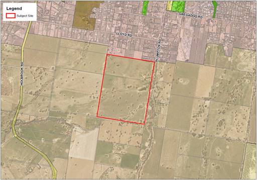
Figure 1: Site and Location
Source: Prepared by staff
The changes proposed in the application will be achieved by amending the land zoning, minimum lot size and urban release area provisions of the WWLEP.
The planning proposal is accompanied by an Urban Design Report (Attachment 3) providing vision, site analysis and master plan for the site (figure 2). The Master Plan in Figure 2 has been used as the basis and foundation for the Urban Design Report and does not include the extended and wider precinct area that has been investigated and is shown in Figure 3. The wider precinct investigation was requested following submission of the initial planning proposal. The key outcomes of the wider precinct, especially connectivity, will be incorporated in the future Draft Development Control Plan if this initial proposal is supported by Council.
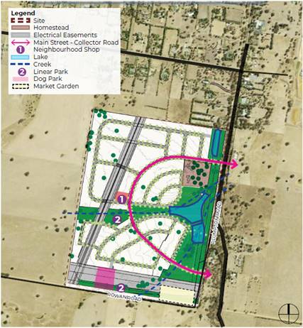
Figure 2: Master Plan
Source: Urban Design Report, SIVA Projects
In addition to planning for the subject site, the master plan considers urban extension for a broader area and gives consideration to the potential for other areas to be rezoned (figure 2).
Figure 2 provides indicative layout for future development including connecting roads. The potential connecting roads extend from Redbank Road in the East through to Holbrook Road in the West. Rowan Road on the southern boundary is not relied on or required to provide or support connections across the potential future urban areas. This connectivity will be reinforced and detailed in further development of the master plan and DCP provisions.
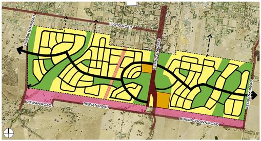
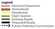
Figure 3: Urban Extension
Source: Urban Design Report, SIVA Projects
Key Considerations
A review of the planning proposal indicates that the site has strategic merit based on the following:
2. The site is a direct extension of the existing large lot urban area.
3. The site is low agricultural grade and not identified as Biophysical Strategic Agricultural Land.
Key considerations for the planning proposal are detailed below:
1. Development Control Plan and Contributions framework
Urban release areas require amendments to the Development Control Plan and the establishment of a contributions framework to ensure growth occurs in an efficient and sustainable manner.
The recommendation is to support the planning proposal and prepare a development control pan amendment and contribution framework prior to submitting to NSW Department of Planning, Industry and Environment (DPiE) for Gateway Determination. The purpose of taking this approach is to provide the applicant with certainty that the proposal has in principle council support based on strategic merit to proceed prior to further investment into detailed studies and design work that will provide site specific merit and detailed outcomes.
This approach is based on the assessment and independent review by Urbis Planning who were engaged and funded by NSW Department of Planning, Industry and Environment (DPiE) on behalf of Council. Ongoing resource shortages and high workloads of the Strategic Planning unit were recognised by DPiE and funding / consultancy assistance was offered to assist with progressing some of the planning proposals in Council’s planning proposal system.
· Wagga Wagga Development Control Plan amendment
As the site is proposed to be an urban release area, a Development Control Plan (DCP) amendment application will need to be submitted by the applicant. The Development Control Plan amendment for this site will need to cover key matters such as connectivity to potential development area to the west, development to be fronting open space and provision of open space.
The amendment will be prepared and exhibited alongside the planning proposal.
· Developer contributions framework
New urban release areas require a contributions framework to enable Council to provide quality public services and amenities to meet the needs of incoming residents of the proposed release area. The framework will enable Council to collect contributions from development towards the provision, extension or augmentation of public services and public amenities that will, or are likely to be, required as a consequence of development.
Addendums to existing citywide infrastructure plans will be prepared and exhibited alongside the planning proposal.
· Full development potential
On request, the proponent has assessed infrastructure capacity for further urban release areas west and east of the subject site (yellow area on figure 3) and intensification of the large lot residential area north of the site (blue area on figure 3).
Figure 3: Development Potential
Source: Application, precinct considerations
At this point in time a broader infrastructure strategy for the identified areas in Figure 3 has not been prepared by Council. Given the proponents desire to proceed, they have been requested to investigate and have consideration to servicing the wider precinct as part of this proposal. The information provided indicates the area can be serviced and connectivity across the precinct catered for. Council’s engineering team have reviewed the information and are satisfied that the area can be suitably serviced. Further solutions and staging will be subject to more detailed investigations and design. This work is proposed subject to Council’s support for the concept plan.
2. Council’s Vision or Strategic Intent
There is a strong commitment through local and regional policy to find a balance between growth, the natural environment, sustainability, and liveability whilst enabling Wagga Wagga to emerge as the southern capital of NSW.
· Riverina Murray Regional Plan 2036
The Riverina Murray Regional Plan 2036 outlines a vision to promote the growth of regional cities and local centres and identifies the significance of aligning infrastructure planning with land release areas. Key actions from the Regional Plan include:
Action 25.3 - Align infrastructure planning with land release areas to provide adequate infrastructure
Council is in the process of revising the infrastructure delivery servicing plan to determine the infrastructure required to service the projected population growth. The site is located outside of the catchment area for the revised servicing plan. The review is anticipated to take 12 months.
Without the revised infrastructure delivery servicing plan in place, the applicant is engaging a consultant to extend on the works Council is currently undertaking for sewer modelling. As part of this process, the applicant will involve Council in the preparation of the brief and review of works.
Action 27.1 – Enable new rural residential development only where is has been identified in a local housing strategy prepared by Council and approved by the Department.
Council has not yet prepared a local housing strategy. Notwithstanding, the LSPS provides an avenue for consideration of growth in areas not identified in the LSPS when infrastructure is available.
· Wagga Wagga Spatial Plan 2013-2043
Whilst the Planning Proposal refers to, and in part, relies upon, the Spatial Plan, this has been superseded by the LSPS. The LSPS was adopted on 8 February 2021, prior to the lodgement of the Planning Proposal.
Each of the action items identified in the Spatial Plan have been considered in the LSPS. The site was originally identified within Area 5 of the Spatial Plan. The Actions for Area 5 state that “the rezoning of this land should be done in conjunction with the planning and investigation of the identified ‘potential road connection.’…the zone and minimum lot size will be considered after the outcomes of the residential study are known.”
This Action has not been included in the final adopted LSPS. Planning and investigation of the potential road connection have not occurred, and Council are yet to prepare their local housing strategy. The LSPS provides an avenue for consideration of growth.
· Wagga Wagga Local Strategic Planning Statement – Wagga Wagga 2040
The LSPS maps the Northern Growth Area as the area that will be focused on for growth through urban release. The site is located outside of this area, however the plan provides an avenue for consideration of growth outside of the Northern Growth Area.
Principle 1: Protect and enhance natural areas and corridors
The LSPS identifies the benefits that existing vegetation, natural areas, and corridors contribute to the city’s presentation and quality of life. Protecting and preserving environmental assets should be prioritised over development.
The Planning Proposal states that the site contains biodiversity corridors and seeks to apply an RE1 zone over those parts of the land which contain waterways, environmentally sensitive land, and high concentrations of vegetation. The Planning Proposal states that there will be offset obligations and the urban design report outlines an intent to plant five trees for every native tree that is removed. A draft BDAR has been prepared to provide preliminary findings with targeted surveys to occur in October / November 2021 to finalise the BDAR. The proponent has identified that the proposal enacts several principles to avoid and minimise impacts to Box-Gum Woodland with details provided within the draft BDAR.
Principle 3: Manage growth sustainably
The LSPS requires that infrastructure provision and capacity is managed and prioritised in decision making for infill development and includes broader considerations and precinct wide planning rather than site specific Planning Proposals in isolation or ad-hoc planning that results in unsustainable outcomes.
The Planning Proposal was accompanied by a precinct wide infrastructure plan, encompassing the site, the developed land to the north and undeveloped / RU1 Primary Production land to the east and west of the site. It assumes that all land within the catchment area would be developed for residential purposes, at a density of 8 dwellings per hectare and 2.6 persons per dwelling (total projected population of 15,600 people).
The precinct wide infrastructure plan states that the site is capable of being connected into the broader infrastructure network and services can be made available to the site. Substantial upgrades will be required to sewer, water, and road infrastructure to support the estimated population. Servicing is further addressed under ‘3. Infrastructure’ below.
Principle 7: Growth is supported by sustainable infrastructure
The LSPS provides opportunities for consideration of areas not specifically identified as growth areas in the LSPS, on the basis that the Planning Proposal addresses the principles of the LSPS including service provision, accessibility, and connectivity.
The Planning Proposal includes supporting information and studies to demonstrate adequate service provision, accessibility, and connectivity solutions. Being an urban release area, Clause 6.2 of the WWLEP 2010 will apply to development applications and consent cannot be given unless the consent authority is satisfied that adequate arrangements have been made to make infrastructure available when required. For the purposes of the planning proposal, it is considered that the information provided shows that the site can be adequately serviced. This will be subject to further detailed technical designs to show the actual servicing including upgrades, staging and funding. Servicing is further addressed under ‘3. Infrastructure’ below.
3. Infrastructure
One of the key issues to consider in the rezoning and future urban development of the site is the impact on existing infrastructure and the ability of existing networks to service the future projected population.
Stormwater
The applicant has submitted two stormwater reports, one covering the subject site and the other covering the broader precinct. The estate report focuses on a strategy for the management of stormwater based on an initial concept layout. The proponent indicates these are best practice principles and techniques that are consistent with stormwater management requirements within Council’s Development Control Plan and Engineering Guidelines. The report demonstrates there are acceptable solutions to manage stormwater.
The precinct report looks at the broader precinct to determine the requirements and impacts if the broader precinct was to be developed at a similar scale to the subject site. The report indicates offline detention basins can provide required detention to achieve ‘no worsening’ stormwater objectives.
The plans are conceptual only and will need to be further tested at design stage as part of any future development application.
Sewer
The LSPS requires infrastructure provision and capacity to be managed on a broader precinct wide scale rather than assessing site-specific Planning Proposals.
The applicant has submitted a Precinct Considerations Sewerage Plan. The following comments are provided in the context of the broader catchment:
· The Kooringal Sewer Treatment Plan (STP) and Kooringal Sewer Pumping Station (SPS) have limited spare capacity (approximately 400 to 500 ET).
· If only the Sunnyside Estate was to be developed (staged delivery over approximately 8-10 years), the full development would absorb all existing capacity in the Kooringal SPS.
· If development was to only be intensified within the “existing development” catchment area, being the existing R5 Large Lot Residential land to the north, the Kooringal SPS would still require upgrading, although not immediately.
· Irrespective of development as presented under the Planning Proposal, the sewerage connection north of Plumpton Road and Nelson Drive would require upgrading.
· Given the demand for housing within the Wagga Wagga LGA, any required sewerage upgrades to service the Sunnyside Estate should be considered on a Precinct wide scale. This would likely require:
o Upgrading the Kooringal Sewer Pumping Station
o Upgrading and augmentation of the sewer pipe north of the intersection of Plumpton Road and Nelson Road
o A new sewer connection from the site, connecting into the existing network at Plumpton Road and Nelson Road. This would require a 375mm dia. sewerage pipe (note: this is greater than the 225mm dia required if only the site was to be developed).
Subject to infrastructure upgrades to the pipe network and the SPS, the site can connect into and be serviced by Council’s sewer network.
Separate to this proposal, Council has engaged a consultant to undertake modelling of the citywide sewer network. The subject site falls outside of the current area being modelled and the proponent will engage the same consultant to extend the modelling to include the subject site. The modelling extension will be done in consultation with Council. This information will be required to support any proposed infrastructure plan for the precinct, and it is proposed this is required prior to Gateway submission to NSW Department of Planning, Industry and Environment.
Water supply
The Sunnyside Estate is currently serviced by an existing water main. The land is at an elevation that is capable of being serviced by the Riverina Water County Council (RWCC).
However, as part of the preliminary discussions, RWCC advised the Proponent that significant assessment and analysis of the capacity of the two separate water supply systems would need to occur to determine the serviceability of the land. Currently, there is insufficient capacity within the system in its current configuration to supply the scale of development presented in the Planning Proposal.
The Planning Proposal identifies that the following upgrades to the water infrastructure would need to occur:
· New infrastructure would be required to increase the supply capacity south of the Plumpton Rd and Gregadoo Rd intersection.
· Upgrades to water main network
· Upgrades to water pump stations
· Increase in reservoir storage capacity.
Given there is insufficient capacity for the development of the subject site, capacity would also be limited if a similar scale of development was to be undertaken within the broader precinct.
The Planning Proposal states that further analysis would be required to determine the exact scope (and associated cost) of works required, including any potential impacts on supply to surrounding areas.
Whilst the proponent has indicated that Council can rely on the Urban Release Area Provision of the LEP to enable rezoning with development unable to occur until satisfactory infrastructure arrangement have been agreed, the recommendation is to prepare the addendum to existing citywide infrastructure plans prior to submitting to DPiE for Gateway Determination.
Traffic
The site has frontage to Plumpton Road in the east and Rowan Road in the south. As Rowan Road is an unsealed rural road, currently not designed for urban traffic, the Planning Proposal relies on future connections to Plumpton Road.
Two traffic reports were provided with the proposal, one a Preliminary Traffic Assessment Report and the other a Traffic Considerations for Indicative Area for the Investigation.
The proponent indicates that these reports provide a reasonable assessment of the likely impact of the proposed traffic from the subject site on the network. Council provided the proponent with traffic volumes for several key roads and these were used to identify indicative traffic impacts. The traffic and transport network has capacity for the additional demand generated by the development subject to augmentation and upgrades. These works will need to be identified and confirmed in the infrastructure servicing plan. It is proposed this be provided prior to submission to DPiE for Gateway Determination.
The proposal has also considered the wider precinct and connectivity. The draft concept plan identifies potential connections through surrounding land, and this will be further considered and identified as part of infrastructure plans prior to any development application. This includes staging and funding of key upgrades and augmentation.
Utilities
Other infrastructure networks and services, including electricity, public transport, waste management/recycling, health, education, emergency, mail, and other community services are established in the local area and accessible to the subject site. The applicant may elect not to implement gas infrastructure as part of sustainability measures; however, connection of the site is possible if required.
4. Biodiversity
The Planning Proposal was accompanied by a preliminary Biodiversity Assessment and on request, a draft Biodiversity Development Assessment Report (BDAR) has been provided. The draft BDAR presents the results of the NSW Biodiversity Assessment Method 2020 (BAM) to assess the significance of the impacts on biota listed as threatened under the NSW Biodiversity Conservation Act 2016 (BC Act). It also includes assessment of potential impacts on Matters of National Environmental Significance (MNES) listed pursuant to the Commonwealth Environment Protection and Biodiversity Conservation Act 1999 (EPBC Act).
From the draft BDAR the following conclusions were made:
· The subject land was assessed as supporting 9.11 hectares of Biodiversity Conservation Act Box-Gum Woodland in highly modified condition. Of that, the proposed rezoning will impact 17% (1.56 hectares).
· The threatened flora credit species flagged by the (BAM) are considered unlikely to occur on the subject land given that the ground-storey and shrub-storey vegetation across the entire subject site is moderately to highly disturbed, shows signs of historic cultivation and/or pasture improvement, supports a variety of weeds, has been heavily grazed, and is currently moderately to heavily grazed by stock and Eastern Grey Kangaroos.
· A total of 72 flora species were recorded during field surveys, comprising 27 native species and 45 exotic species. None of the EPBC or BC Act threatened flora credit species identified in the draft BDAR were recorded on the subject land or are likely to occur.
· A total of 44 native fauna species were recorded during field surveys, comprising 42 bird species, one amphibian species, and one mammal species. Two exotic fauna species were recorded, comprising on bird and one mammal.
· One ecosystem credit species have been considered in the draft BDAR. Due to seasonal constraints, targeted surveys to confirm the presence/absence for the relevant credit species were not possible for the draft BDAR. Targeted surveys will be undertaken in October / November.
· The proposed rezoning / development enacts a number of principles to avoid and minimise the impacts to Box-Gum Woodland.
· Potential indirect impacts, including indirect impacts to Box-Gum Woodland, will be minimised and mitigated by a number of techniques.
· The rezoning / development will generate ecosystem credit obligations.
· The subject site is considered unlikely to constitute important or occupied koala habitat now or in the future.
The final BDAR will be completed prior to the planning proposal being finalised.
5. Planning Agreement
The Planning Proposal Report identifies a variety of development contributions that could be considered by the Proponent to provide for a range of infrastructure to meet the needs of the future population.
To better understand the public benefits associated with the Planning Proposal, beyond the development requirements necessary to support the development of the site, a formal public benefit offer should be submitted which clearly outlines what monetary contributions and / or works in kind the Proponent is proposing and at what stage of the development these contributions or works would occur.
Conclusion
The planning proposal has demonstrated strategic planning merit and is consistent with the vision and outcomes provided in the LSPS.
There are several specific items where further detail has been identified as being necessary. This is a shift in focus and emphasis on infrastructure design, provision, and financing to provide Council and the community with more certainty and understanding of the impacts and implications of the proposal. This will require financial investment and resourcing from the proponent to undertake this work. The planning proposal is supported and subject to the proponent providing further reports and investigations as the proposal progresses.
Financial Implications
In accordance with Council’s 2020/21 Fees and Charges, a Major LEP Amendment has a total application fee of $44,000.00. The proponent has paid these fees.
It is anticipated the LEP amendments will result in new development on the subject land in the future. This has financial implications for Wagga Wagga City Council.
Contribution and development servicing plan addendums will be required to any they apply to any future development of the land. These addendums will be developed and exhibited alongside the planning proposal.
Policy and Legislation
Environmental Planning and Assessment Act 1979
Wagga Wagga Local Strategic Planning Statement – Wagga Wagga 2040
Wagga Wagga Local Environmental Plan 2010
Link to Strategic Plan
The Environment
Objective: We plan for the growth of the city
Outcome: We have sustainable urban development
Risk Management Issues for Council
The planning proposal has been assessed and it is recommended it be submitted to NSW Department of Planning, Industry and Environment for Gateway Determination. If issued, the determination will require public and agency consultation. Consultation may highlight issues not evident during the assessment.
Internal / External Consultation
Formal public consultation with agencies, adjoining landowners and the public will occur if Gateway Determination is received.
A Councillor workshop on this Planning Proposal was held on 20 September 2021 where concerns were raised regarding the infrastructure and servicing of the site, connectivity across the wider precinct, the provision, location and quality of open space, interaction of residential development and open space as well as stormwater treatment and management.
Further commentary on the issues raised is provided below:
i. Wider precinct – connectivity and servicing
Figure 2 shows the indicative layout for future development. Connectivity and servicing for the wider precinct will be reinforced and detailed through the development of the DCP provisions and addendum to existing citywide contribution plans.
ii. Open Space
As the site is a proposed urban release area, a DCP amendment for the site will cover key matters, including the location and standards for the provision of open space. These provisions will require development to front open space.
Details on proposed improvements and infrastructure is included in the urban design report with open space and vegetation as a design principle. The plan intends to incorporate linear open spaces similar to that provided in Gobbagombalin, riparian landscape, formal playgrounds, informal grass areas and retained habitat areas. The spaces identified are proposed to cater for various activities and encourage outdoor lifestyle. To connect the various open spaces, a network of walking and cycling paths is proposed.
The open space network will add environmental value to the community including ecological habitat, passive recreation, active recreation, stormwater conveyance, and fauna movement.
iii. Stormwater
The application is accompanied by two stormwater reports that provide a strategy for the management of stormwater consistent with Council’s DCP and Engineering Guidelines. The report demonstrates there are acceptable solutions to manage stormwater for the conceptual plans with further detail and testing at design stage required as part of any future development application.
Detention basins in centralised open space corridors is not unusual and has been incorporated successfully in other city locations (Gobbagombalin) to popular effect whilst managing stormwater and minimising environmental impacts.
Details proposed in the urban design report seek to implement high quality water bodies containing ecological habitats with bridges, boardwalks, and decks enabling interaction with nature.
Full consultation details and a consultation plan will be reported back to Council along with the proposed DCP amendment and addendum to existing citywide contribution plans.
|
1. |
LEP21/0001 - Planning Proposal - Provided under separate cover |
|
|
2. |
LEP21/0001 - Assessment Report - Provided under separate cover |
|
|
3. |
LEP21/0001 - Urban Design Report - Provided under separate cover |
|
|
4. |
LEP21/0001 - Preliminary Assessment Report for Intended Planning Proposal - Provided under separate cover |
|
|
5. |
LEP21/0001 - Stormwater Report - Provided under separate cover |
|
|
6. |
LEP21/0001 - Sewage Report - Provided under separate cover |
|
|
7. |
LEP21/0001 - Traffic Report - Provided under separate cover |
|
|
8. |
LEP21/0001 - Precinct Water Supply Considerations - Provided under separate cover |
|
|
9. |
LEP21/0001 - State Environmental Planning Policies - Provided under separate cover |
|
|
10. |
LEP21/0001 - Section 9.1 Directions - Provided under separate cover |
|
|
11. |
LEP21/0001 - Update letter and draft BDAR - Provided under separate cover |
|
|
12. |
LEP21/0001 - Land Owners This matter is considered to be confidential under Section 10A(2) of the Local Government Act 1993, as it deals with: personnel matters concerning particular individuals. - Provided under separate cover |
|
|
Report submitted to the Ordinary Meeting of Council on Monday 11 October 2021 |
RP-3 |
RP-3 Northern Growth Area Infrastructure and Contributions
Author: Belinda Maclure
Director: Michael Keys
|
Summary: |
High rates of development continue across the northern growth area. To support this development, new infrastructure with an estimated cost of $15 million is required.
The most significant infrastructure relates to stormwater treatment and management. Additional stormwater infrastructure is required to service future and existing areas of Boorooma, Estella, Gobbagombalin and River Road. It is proposed to partly fund this infrastructure through an amendment to existing Development Servicing Plan (DSP) Stormwater.
To ensure Section 64 Sewer contributions are captured to fund sewer infrastructure in the new development area of River Road an addendum to the DSP Sewerage is proposed.
To ensure Section 7.11 contributions are captured and reflect the cost to provide open space and transport infrastructure in River Road development area, changes to the Wagga Wagga Local Infrastructure Contributions Plan 2019 – 2034 (LICP) are required and have been provided in the form of an appendix. |
|
That Council: a endorse the draft Wagga Wagga City Council Development Servicing Plan Stormwater 2007 - Addendum for Estella, Boorooma, Gobbagombalin and River Road September 2021, to be placed on public exhibition and invite public submissions for a period of 42 days from 17 October 2021 to 29 November 2021. b endorse the draft DSP Sewerage - Addendum for River Road September 2021, to be placed on public exhibition and invite public submissions for a period of 42 days from 17 October 2021 to 29 November 2021. c endorse the draft Wagga Wagga Local Infrastructure Contributions Plan 2019 – 2034 - Appendix G, to be placed on public exhibition and invite public submissions for a period of 42 days from 17 October 2021 to 29 November 2021. d receive a further report following the exhibition and submission period addressing any submission made in respect of the draft documents |
Report
The northern growth area consists of Estella, Booroooma, Gobbagombalin and River Road. This area continues to be the main focus of growth for the City which is expected to continue into the medium and longer term. Planning for the provision and rollout of supporting infrastructure is a critical challenge that relies on infrastructure contributions plans for local infrastructure, particularly open space, traffic facilities as well as stormwater and sewer networks.
The following table provides a summary of the proposed infrastructure contributions for the northern growth area.
|
Contribution Plan |
Estella, Boorooma, Gobbagombalin |
River Road |
|
Section 7.11 |
$19,122 |
$18,720** |
|
Section 64 Stormwater* |
$2,829 |
$2,829** |
|
Section 64 Sewer |
$4,154 |
$4,154** |
|
Section 64 Water (Riverina Water) |
$5,053 |
$5,053 |
|
Total |
$31,158* |
$30,756* |
* Includes an increase of $519 per lot on existing charge
** New charges proposed across River Road precinct including new Appendix G to 7.11 Plan
Stormwater Infrastructure for the Northern Growth Area
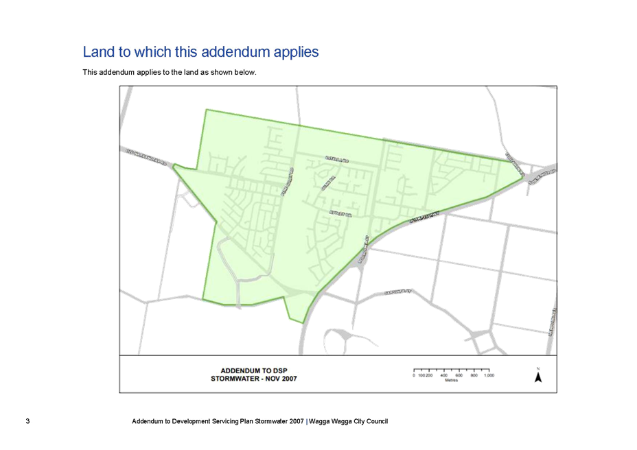
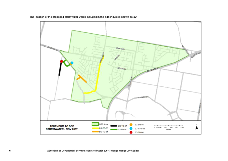
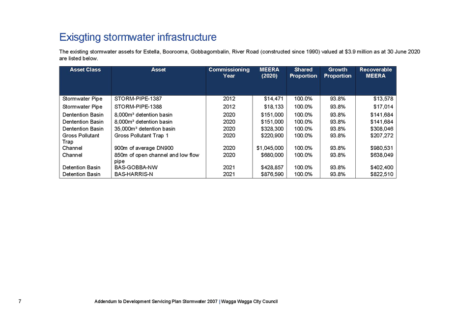
Council has investigated the capacity of the existing stormwater infrastructure within the northern growth area and as a result identified additional infrastructure required to support both existing and future development in Estella, Boorooma, Gobbagombalin and River Road.
The investigation has identified a long-term solution for the management of stormwater runoff from development areas. Historically, Council relied on detention at the edge of the floodplain, the new design will to manage the flow using the natural flowpath towards the significant lagoon at the bottom of the catchment, whilst ensuring protection of this and creating amenity for the area.
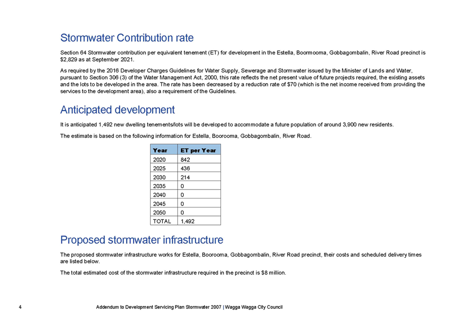
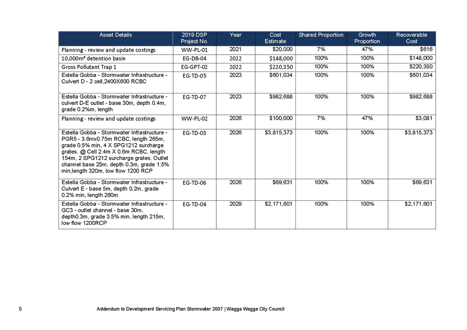
The high-level costing of the stormwater infrastructure required in the next 10 years to support the northern growth area is estimated at $8 million. This infrastructure consists of large-scale trunk drainage, detention basins (with gross pollutant traps) and enhancement and protection works to the natural water course flowpaths.
This infrastructure is not in the DSP Stormwater 2007. To ensure the Section 64 Stormwater rate more accurately reflects the cost of providing infrastructure to support development, a draft Addendum of the DSP Stormwater 2007 has been developed.
The draft Addendum proposes to increase the Section 64 Stormwater contribution rate for the northern growth area to $2,829 per ET, a rise of $519 per lot from the current $2,310 rate. Outside the annual increase related to CPI, this is the first major increase to Section 64 Stormwater contributions since 2007. This is the maximum contribution rate Council can collect for the area based on the methodology outlined in the 2016 Developer Charges Guidelines for Water Supply, Sewerage and Stormwater.
The increase to the existing development area will affect the cost of improvements to support the existing catchment areas. This is well short of the costs that would be apportioned based on area.
The total cost of improvements and new work to support both existing and new development is estimated at $8 million. Of this it is proposed that the new development through the Stormwater DSP will generate $4.2 million. This will be supplemented by an existing DSP reserve of $1.025 million and as well as further funds from the Citywide stormwater levy. This is recommended based on the rates proposed to provide a long term sustainable solution that supports existing development in addition to future growth. The proposed works address existing and ongoing concerns with stormwater management systems.
Sewer Infrastructure for River Road
All lots developed in the Wagga Wagga local government area (in the DSP Sewer area) are required to pay Section 64 Sewer infrastructure contributions of $4,154 (as at 2021/22).
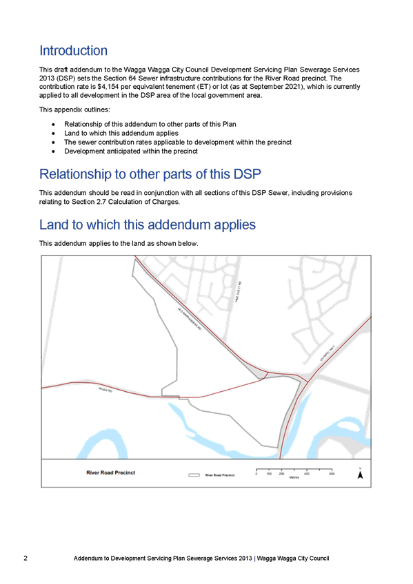
To ensure Council collects Section 64 Sewer contributions to fund sewerage infrastructure to support the River Road precinct, a draft Addendum to the DSP Sewerage Services 2013 has been developed. This Addendum extends the DSP Sewer area to include the River Road development.
Open Space and Traffic Infrastructure for River Road
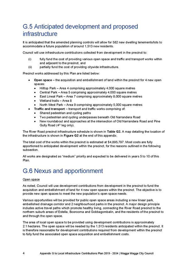
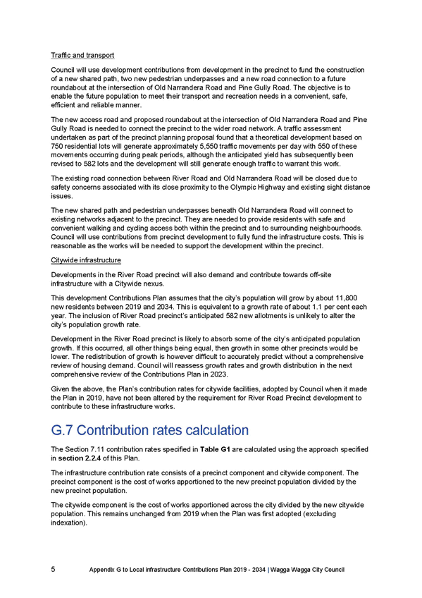
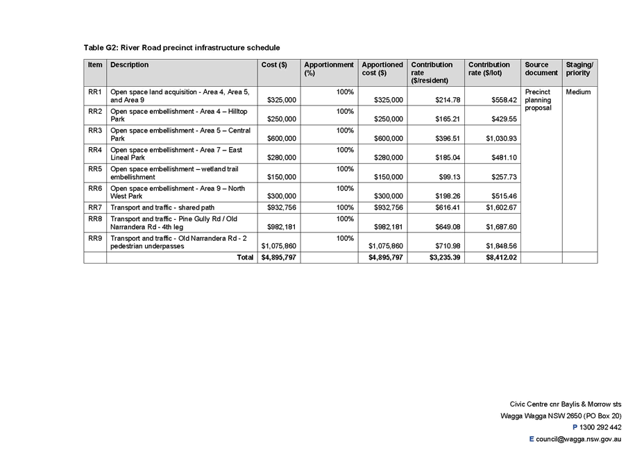
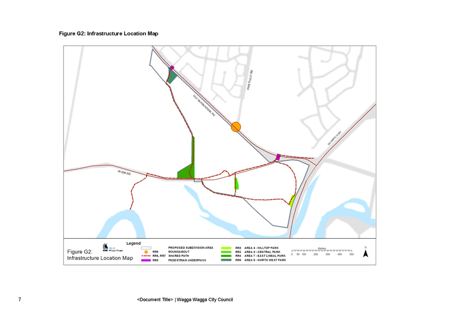
The proposed River Road development area will include a new open space, recreation and community facilities as well as traffic infrastructure directly required as a result of the development. None of these items are currently included in the LICP. To ensure Section 7.11 contributions are captured for the new development area of River Road and they reflect the cost of providing more facilities, a draft Appendix G of the LICP has been developed.
Key elements proposed to be funded include open space parks and playgrounds, active travel connections and an improved intersection at Old Narrandera Road. The River Road precinct provides an ideal opportunity to link key recreational sites (the public reserve on Murrumbidgee River for example) and the City wide Active Travel Path including Gobbagombalin, Boorooma and Estella. A network of shared paths is proposed linking 2.1 hectares of open space within the new River Road precinct. This network will link up with the shared paths in Gobbagombalin and Boorooma, with two pedestrian underpasses proposed on Old Narrandera Road. The underpasses will be funded through Section 7.11 contributions provided in draft Appendix G for the River Road precinct.
The River Road development triggers the need for a roundabout at Pine Gully Road and Old Narrandera Road intersection. Upgrades to this intersection, including associated contributions, from the precincts of Estella, Boorooma and Gobbagombalin have previously been identified and are being funded as part of project TT2 Pine Gully Road corridor in the LICP. The additional cost of the roundabout apportioned to River Road reflects the additional funding required for the intersection upgrade.
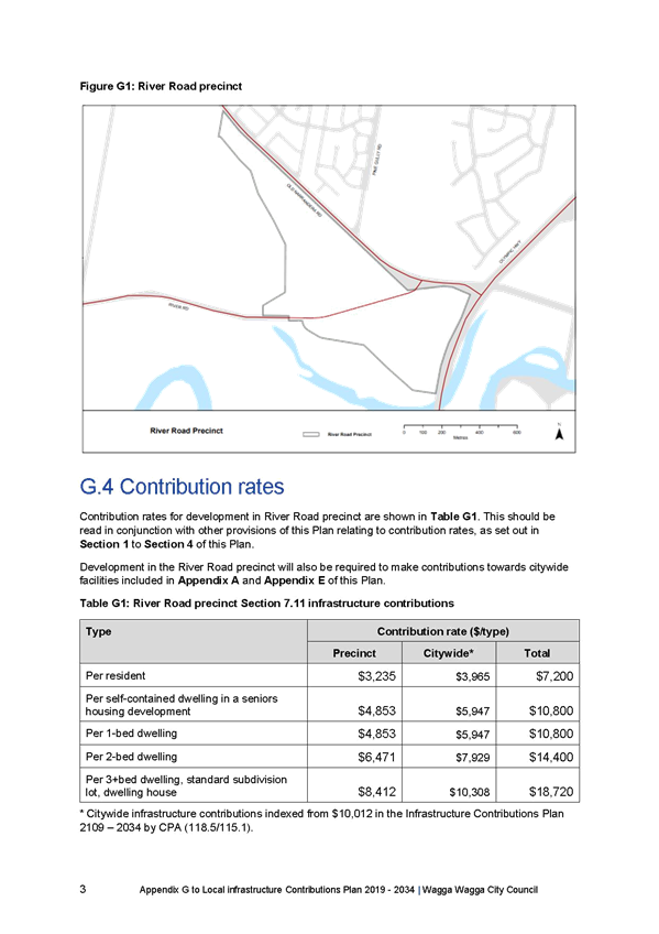
The proposed Section 7.11 infrastructure contribution rate for the River Road precinct is $18,720. This includes the citywide rate of $10,308, applicable to every lot developed across the local government area, plus $8,412 for the infrastructure, specifically identified to support the River Road development.
Financial Implications
Stormwater
The stormwater infrastructure required in the northern growth area with an estimated cost of $8 million will be partly funded by the Section 64 Stormwater contributions. This includes forecast Section 64 Stormwater contributions from the remaining lots in the northern growth area of $4.2 million over the next 10 years and $1.025 million from the existing Section 64 Stormwater Reserve for the northern growth area as at 30 June 2021.
This leaves a shortfall of approximately $2.7 million. The anticipated funding shortfall will be funded by the Stormwater levy. It is expected the Stormwater levy will be used to part fund project EG-TD-03 (as detailed in the Addendum DSP Stormwater) scheduled to be delivered in 2026 and EG-TD-04 as described in the Addendum, scheduled for delivery in 2029.
Sewer
The Addendum to the DSP Sewerage Services extends the DSP Sewer area to include River Road and enables Council to collect Section 64 Sewer contributions for the precinct. This funding will be held in the Sewer Reserve and used to provide infrastructure to support the area.
Open Space and Traffic
Appendix G details the infrastructure required to support the River Road precinct. Projects within the precinct (including the underpasses on Old Narrandera Road) are 100% funded by Section 7.11 infrastructure contributions. This ensures there is no funding shortfall of the projects identified.
The changes required at the Old Narrandera Road and Pine Gully Road intersection as a result of the River Road development are apportioned to the River Road precinct.
Policy and Legislation
Environmental Planning and Assessment Act 1979 Section 7.11 and 7.12
Section 64 Local Government Act
Wagga Wagga Local Infrastructure Contributions Plan 2019 2034
Wagga Wagga City Council Development Servicing Plan Sewerage Services 2013
Wagga Wagga City Council Development Servicing Plan Stormwater 2007
Link to Strategic Plan
The Environment
Objective: We plan for the growth of the city
Outcome: We have sustainable urban development
Risk Management Issues for Council
Council faces a high risk of Section 64 Stormwater infrastructure contributions for the northern growth area not reflecting the true cost of providing stormwater assets to support development in this high growth area in the short to medium term if the rate is not reviewed as suggested in the Addendum to the DSP Stormwater. This will see the funding shortfall increase and may make it impossible to provide the infrastructure to manage stormwater in the area, increasing the risk of flooding of property and environmental damage.
The new development area of River Road is not in the current DSP Stormwater or DSP Sewerage Services. The Addendums to the DSP documents extend the DSP area, enabling Council to charge Section 64 Sewer and Stormwater infrastructure contributions when the development applications for subdivision are received. This will then generate revenue to provide the required infrastructure to support the development.
River Road precinct is not included in the LICP. If the LICP is not updated to include this area, Council may collect Section 7.11 contributions from the development which do not reflect the true cost of providing the required open space and traffic projects in the precinct.
Internal / External Consultation
A Community Engagement Plan has been developed to guide the consultation with developers in the northern growth area in particular. The Community Engagement Plan is attached.
|
|
|
Media |
Community Engagement |
Digital |
|||||||||||||
|
Rates notices insert |
Direct mail |
Letterbox drop |
Council news story |
Council News advert |
Media releases |
TV/radio advertising |
One-on-one meetings |
Your Say website |
Community meetings |
Stakeholder workshops |
Drop-in sessions |
Surveys and feedback forms |
Social media |
Email newsletters |
Website |
Digital advertising |
|
|
TIER |
|||||||||||||||||
|
Consult |
|
|
|
|
|
|
|
|
|
|
|
|
|||||
|
Involve |
|
|
|
|
|
|
|
|
|||||||||
|
Collaborate |
|
x |
|
x |
x |
|
|
x |
x |
x |
x |
x |
|
|
|
|
|
|
1⇩. |
Wagga Wagga City Council Development Servicing Plan Stormwater 2007 Draft Addendum for Estella, Boorrooma, Gobbagombalin and River Road September 2021 |
|
|
2⇩. |
Wagga Wagga City Council Development Servicing Plan Sewerage Services 2013 Draft Addendum for River Road September 2021 |
|
|
3⇩. |
Wagga Wagga Local Infrastructure Contributions Plan 2019 – 2034 Draft Appendix G River Road September 2021 |
|
|
4⇩. |
Community Engagement Plan |
|
|
Report submitted to the Ordinary Meeting of Council on Monday 11 October 2021 |
RP-4 |
RP-4 Transgrid Humelink - Community Consultative Group Representative Nomination
Author: Michael Keys
General Manager: Peter Thompson
|
Summary: |
Transgrids HumeLink project is a critical state significant infrastructure project linking Wagga Wagga, Maragle and Bannaby. The project will maximise the national electricity grid capacity to deliver electricity to major population centres.
Council has received an invitation to participate in, and nominate a representative for the Transgrid HumeLink Community Consultative Group.
This includes a request to nominate one elected representative and a relevant staff member as an alternative delegate. It is recommended that Council select and nominate an elected representative for this project. |
|
That Council nominate an elected representative for the Transgrid HumeLink Community Consultative Committee up to the 2021 Council elections. |
Report
HumeLink is a new 500kV transmission line which will carry electricity to customers. It will connect Wagga Wagga, Bannaby and Maragle.
A recent review of the HumeLink project consultation and representation from affected landowners identified concerns with community engagement and consultation. Improvements have been identified including the formation of Community Consultation Groups to improve consultation and community representation.
Council has received an invitation to participate in and nominate representatives for the Transgrid HumeLink Community Consultative Group (CCG). In partnership with Transgrid, WSP are establishing three independent Community Consultative Groups (CCG’s) to represent communities in the:
· Wagga Wagga and Cootamundra Gundagai LGAs
· Yass Valley and Upper Lachlan LGA’s
· Snowy Valleys LGA
The Community Consultative Group will provide an opportunity for discussion between Transgrid and landowners, local community organisations, councils and other members of the communities in the HumeLink project study corridor.
The CCG is expected to commence in October 2021 and will meet at least twice before the end of this year. It is envisaged that at minimum, four meetings will be held throughout 2022.
With the pending 2021 Council election it is anticipated the nominee will represent Council for the current Council term and a further representative nominated in 2022 following formation of the new Council.
Financial Implications
There are no direct financial implications for Council in participating on the Community Consultative Group.
Policy and Legislation
N/A
Link to Strategic Plan
Community Leadership and Collaboration
Objective: We are active community members
Outcome: We recognise we all have a role to play
Risk Management Issues for Council
The Transgrid HumeLink project is a significant and major infrastructure project. As the project has the potential to impact on our community and assets it is important that Council actively participate in and engage with the Community Consultative Group for this project. This will ensure that Council and the wider community’s interests are represented and taken into account in the project planning and development.
Internal / External Consultation
The Community Consultative Group will be a key element in stakeholder engagement for the Transgrid HumeLink project. In participating in the Community Consultative Group Council will be able to represent the local and broader regional community’s interests.
|
Report submitted to the Ordinary Meeting of Council on Monday 11 October 2021 |
RP-5 |
RP-5 Community@Work Program - Request for Additional Funding
Author: Carolyn Rodney
General Manager: Peter Thompson
|
Summary: |
The Community@Work Fund is aimed at providing an avenue for community members/organisations to request financial assistance for their proposed capital work or one-off activity which is primarily for the benefits of a community need which is not otherwise being met.
There was $95,372 in funding available for the Community@Work Fund for the 2021/22 financial year. Council resolved at its meeting on the 26 July 2021 to allocate $44,296 to seven (7) applications. The total unallocated amount of $51,076 is held in the Community Works Reserve and is made available for the 2022/23 funding round.
The North Wagga Residents Association were granted an allocation of $20,000 and are requesting an additional $8,200 in funding which is detailed for Council’s consideration.
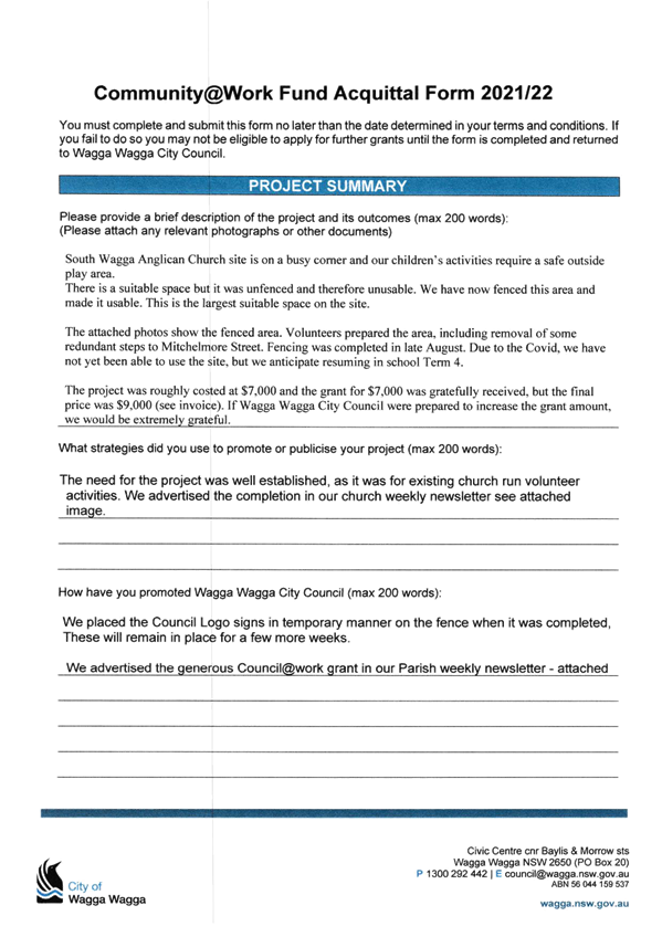
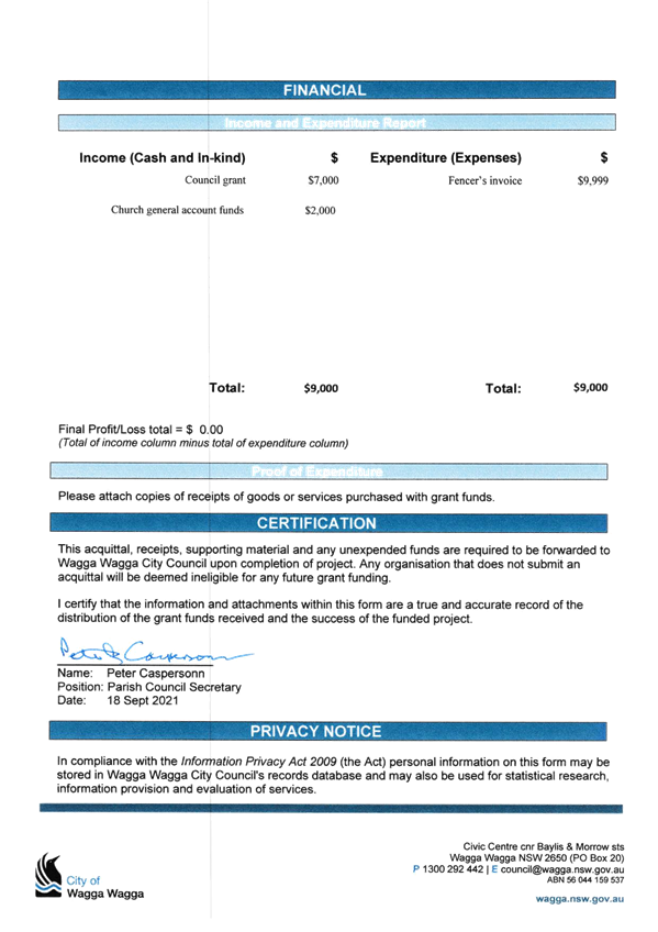
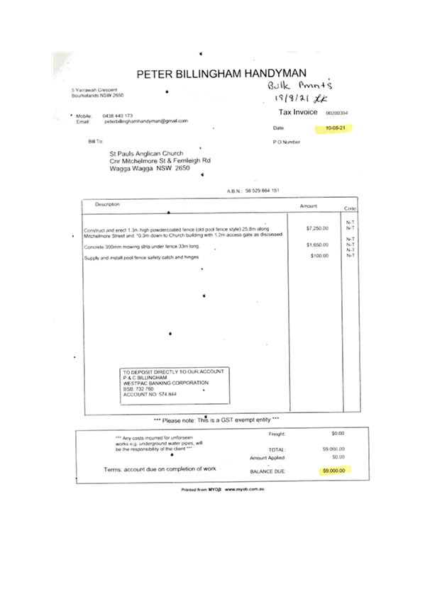
The South Wagga Anglican Church were granted an allocation of $7,000 and are requesting an additional $2,000 in funding which is detailed for Council’s consideration.
|
|
That Council respectfully decline the following requests for additional Community@Work funding from the following groups: i. North Wagga Residents Association (Request 1) ii. South Wagga Anglican Church (Request 2) |
|
|
Report
Two (2) requests for additional Community@Work funding within 2021/22 are proposed for consideration at the 11 October 2021 Ordinary Council meeting, which is shown below:
1. North Wagga Residents Association
Peter Morris, Project Driver at the North Wagga Residents Association writes:
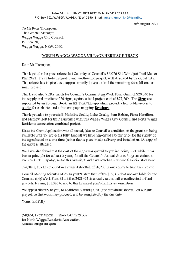
Dear Mr Thompson,
Thank you for the press release last Saturday of Council’s $6,076,864 Wiradjuri Trail Master Plan 2021. It is a truly integrated and worth-while project, well deserved by this great City. This release has inspired us to appeal directly to you to fund the remaining shortfall on our small project.
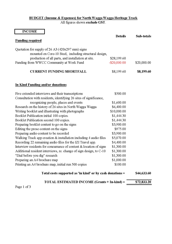
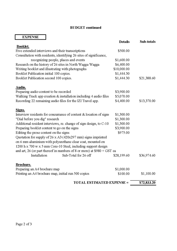
Thank you also VERY much for Council’s Community@Work Fund Grant of $20,000 for the supply and erection of 26 signs, against a total project cost of $77,769. The Signs are supported by an 80-page Book, an IZI.TRAVEL app which provides free public access to Audio for each site, and a free one-page mapping Brochure.
Thank you also to your staff, Madeline Scully, Luke Grealy, Sam Robins, Fiona Hamilton, and Mathew Holt for their assistance with this Wagga Wagga City Council and North Wagga Residents Association combined project.
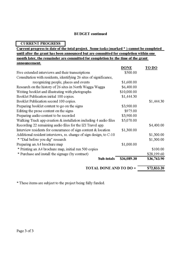
Since the Grant Application was allocated, (due to Council’s condition on the grant not being available until the project is fully funded) we have negotiated a better price for the supply of the signs based on a one-time (rather than a piece-meal) delivery and installation. (A copy of the quote is attached.)
We have also found that the cost of the signs was quoted to you including GST while it has been a principle for at least 3 years, for all the Council’s Annual Grants Program claims to exclude GST. I apologize for this oversight and have attached a revised financial statement.
Together, this has resulted in a revised shortfall of $8,200 in our ability to fund this project.
Council Meeting Minutes of 26 July 2021 state that, of the $95,372 that was available for the Community@Work Fund Grant this 2021~22 financial year, not all was allocated to fund projects, leaving $51,086 to add to this financial year’s further accumulation.
We appeal directly to you, to additionally fund $8,200, the remaining shortfall on our small project, so that work may proceed, and be completed by the due date.
Yours Faithfully
Peter Morris
For North Wagga Residents Association
Attached to this report is the 5 July 2021 Councillor Workshop Briefing Paper where all requests for the Community@Work funding were discussed by Councillors present. Also attached is the Outcomes document for Councillors Information. The outcomes from the Councillor workshop were used to inform the funding allocations approved at the 26 July Council meeting, where the North Wagga Residents Association were allocated $20,000.
The North Wagga Residents Association funding allocation of $20,000 from the Community@Work program in 2021/22 was conditional on the group obtaining the required additional funds to complete the project, either via other state or federal government agencies, or fundraising activities.
A subsequent Councillor Workshop was held on 20 September 2021 to discuss the additional funding request, with the Outcomes Document attached to this report. The majority of the Councillors present at this workshop supported the $20,000 total grant amount at this time.
2. South Wagga Anglican Church
Peter Caspersonn, Parish Council Secretary at the South Wagga Anglican Church writes:
Thank you for your grant to fence a play area at our Turvey Park church site.
Attached are the completion report, photos of completion and of the signage and advertising, and a copy of the fencer's invoice.
The grant for $7,000 was greatly appreciated. Our application was based on an estimated cost, in the end, we extended the fence and the price came to $9,000. Is it possible to ask for an additional $2,000, so we can say the project was fully funded by the community@work grant. I leave this request with you.
Yours with thanks,
Peter Caspersonn,
Parish Council Secretary
18 Sept 2021
As noted earlier in this report, attached to this report is the 5 July 2021 Councillor Workshop Briefing Paper where all requests for the Community@Work funding were discussed by Councillors present. Also attached is the Outcomes document for Councillors Information. The outcomes from the Councillor workshop were used to inform the funding allocations approved at the 26 July Council meeting, where the South Wagga Anglican Church were allocated $7,000.
All applications received under the Community@Work grant for 2021/22 were carefully assessed based on the information provided at the time from each applicant. Council staff note from the request letter that the fence construction was extended in length after the funding application was submitted to Council. As this is a change in project scope, it is for this reason that Council staff are respectfully declining the request for additional funds be allocated at this time.
Financial Implications
|
Community@Work Grant Funding |
|
|
Unallocated balance of 2021/22 Community@Work Grant Funding held in the Community Works Reserve |
$51,076.00 |
|
1) North Wagga Residents Association |
- |
|
2) South Wagga Anglican Church |
- |
|
Subtotal of additional funding requests included in this report – proposed to be funded from the Community Works Reserve |
- |
|
Balance of Community@Work Grant funding to be held in the Community Works Reserve – to be added to the 2022/23 Community@Work Grant funding round |
$51,076.00 |
Policy and Legislation
POL 078 – Financial Assistance Policy
Link to Strategic Plan
Community Leadership and Collaboration
Objective: We have strong leadership
Outcome: We are accountable and transparent
Risk Management Issues for Council
N/A
Internal / External Consultation
Cross Directorate consultation has been undertaken as required.
|
1⇩. |
North Wagga Residents Association - Request for Additional Funding |
|
|
2⇩. |
North Wagga Residents Association - Estimate of cost (Budget) |
|
|
3⇩. |
South Wagga Anglican Church - Community@Work Grant Completion Report |
|
|
4⇩. |
South Wagga Anglican Church - Invoice |
|
|
5. |
Briefing Paper - Community@Work Fund Grant Applications This matter is considered to be confidential under Section 10A(2) of the Local Government Act 1993, as it deals with: commercial information of a confidential nature that would, if disclosed, prejudice the commercial position of the person who supplied it. - Provided under separate cover |
|
|
6. |
Outcomes Document - Community@Work Fund Grant Applications This matter is considered to be confidential under Section 10A(2) of the Local Government Act 1993, as it deals with: commercial information of a confidential nature that would, if disclosed, prejudice the commercial position of the person who supplied it. - Provided under separate cover |
|
|
7. |
Outcomes Document - Community@Work Fund Councillor Workshop - 20 September 2021 This matter is considered to be confidential under Section 10A(2) of the Local Government Act 1993, as it deals with: commercial information of a confidential nature that would, if disclosed, prejudice the commercial position of the person who supplied it. - Provided under separate cover |
|
|
Report submitted to the Ordinary Meeting of Council on Monday 11 October 2021 |
RP-6 |
Author: Tara Donaldson
General Manager: Peter Thompson
|
Summary: |
Amendments have been made to the former Child Protection Policy (POL 083) (now titled Child Safe Policy) requiring the endorsement of Council and subsequent public exhibition. |
|
That Council: a endorse the draft Child Safe Policy (POL 083) (attached in Appendix 1), that is to be placed on public exhibition for a period of 28 days from 12 October 2021 to 9 November 2021 and invite public submissions until the 23 November 2021 on the draft Policy b receive a further report following the public exhibition and submission period: i addressing any submissions made with respect to the proposed Child Safe Policy (POL 083); and c proposing adoption of the Policy unless there are any recommended amendments deemed to be substantial and requiring a further public exhibition period. |
Report
A scheduled review of Council’s Child Protection Policy (POL 083) has been undertaken, aligning the policy with the recent child protection legislative changes and Council’s commitment to being a Child Safe Organisation.
The draft policy as attached has been revised with the following proposed amendments:
· Scope – extended to include all Council workers and contracted service providers of Council.
· Statement of Policy – changed to reflect new legislative requirements (i.e. requirement to implement the new NSW Child Safe Standards across organisational policies, processes and systems).
· Assigning Categories to Roles – new section added to the policy.
· Recruitment and Employment – new section added to the policy.
· Training and Support – new section added to the policy.
· Risk Management Plans – new section added to the policy.
· Complaints Management and Reporting – changed to reflect new legislated complaints handling and reporting requirements.
· Grants and Contracts involving Child-Related Work – new section added to the policy.
· Responsibilities – addition of Workers required to hold a NSW Working with Children Check and Public Officer. Responsibilities also updated in accordance with new legislative requirements.
· Legislative Context – updated currency.
· Related Documents – updated currency.
· Definitions – updated in accordance with policy content updates.
To allow community feedback on the draft Policy, it is recommended that the draft Policy be placed on public exhibition for 28 days from 12 October 2021 to 9 November 2021 and invite public submissions until the 23 November 2021.
Financial Implications
N/A
Policy and Legislation
Child Safe Policy (POL 083)
Child Protection (Offenders Registration) Act 2000
Child Protection (Working with Children) Act 2012
Child Protection (Working with Children) Regulation 2013
Children and Young Persons (Care and Protection) Act 1998
Children’s Guardian Act 2019
Children’s Guardian Amendment (Child Safe Scheme) Bill 2021
Link to Strategic Plan
Safe and Healthy Community
Objective: We are safe
Outcome: We promote safety and safe behaviours
Risk Management Issues for Council
Council policies are essential to ensure transparent legal, fair and consistent decision making across the Council. They support Council in achieving its corporate objectives and provide a critical guide for staff, Councillors and other stakeholders. In the absence of effective policies there is a greater risk of inconsistency, confusion and inefficiency and can lead to non-compliance with the requirements of legislation and regulations.
Internal / External Consultation
To date, the draft Child Safe Policy (POL 080) has been reviewed internally by staff and Council’s Executive Team.
|
|
|
Media |
Community Engagement |
Digital |
|||||||||||||
|
Rates notices insert |
Direct mail |
Letterbox drop |
Council news story |
Council News advert |
Media releases |
TV/radio advertising |
One-on-one meetings |
Your Say website |
Community meetings |
Stakeholder workshops |
Drop-in sessions |
Surveys and feedback forms |
Social media |
Email newsletters |
Website |
Digital advertising |
|
|
TIER |
|||||||||||||||||
|
Consult |
|
|
|
|
|
|
|
|
|
|
|
|
|||||
|
Involve |
|
|
|
|
|
|
|
|
|||||||||
|
Collaborate |
|
|
|
|
|
|
|
|
|
|
|
|
|
|
|
|
|
|
1⇩. |
Draft - Child Safe Policy (POL083) |
|
|
Report submitted to the Ordinary Meeting of Council on Monday 11 October 2021 |
RP-7 |
RP-7 DISCLOSURE OF PECUNIARY INTEREST RETURNS - COUNCILLORS AND DESIGNATED STAFF 2021
Author: Ingrid Hensley
General Manager: Peter Thompson
|
Summary: |
Clause 4.21 of the Model Code of Conduct requires all Councillors and Designated Staff to complete an annual Disclosure of Pecuniary Interest Return. |
|
That the Register of Pecuniary Interest Returns, containing current returns of Councillors and Designated Staff for the period 1 July 2020 to 30 June 2021 be tabled in accordance with Clause 4.21 of the Model Code of Conduct. |
Report
Under Clause 4.21 of the Code of Conduct, certain council officials, namely councillors and designated persons, are required to disclose their personal interests in publicly available returns of interests. These operate as a key transparency mechanism for promoting community confidence in council decision making, whether by councillors or by staff or others under delegation.
A Pecuniary Interest is described in Clause 4.1 of the Code as “an interest that you have in a matter because of a reasonable likelihood or expectation of appreciable financial gain or loss to you or a person referred to in clause 4.3 of the Code”.
All returns of interests are to be lodged with the council’s general manager who must keep a register of returns required to be made and lodged with them. A return lodged within 3 months of 30 June must be tabled at the first council meeting after the last day the return was required to be lodged.
The General Manager reviewed the list of Designated Persons in the previous return period and, as a result, the number of persons who were required to complete and lodge a Return under Clause 4.21, was reduced. The result of this review continues to be reflected in the current register.
Lodgement of Declarations of Pecuniary Interest Returns was required by 30 September 2021. As at 6 October 2021, returns were received from eight (8) of eight (8) Councillors and all Designated Persons as required under the Code. One of the returns submitted by a Councillor was lodged on 1 October 2021 and another on 6 October 2021. Returns from all other Designated Persons were lodged by 30 September 2021, with the exception of one (1) return which was lodged on 5 October 2021.
Accordingly, Council’s register of Pecuniary Interest Returns 2021 is submitted to this meeting of Council as prescribed by the Code.
Councils must make all returns of interests publicly available in accordance with the requirements of the Government Information (Public Access) Act 2009, the Government Information (Public Access) Regulation 2009 and any guidelines issued by the NSW Information Commissioner. One return is currently redacted in the attachment to this report, following assessment of a request for same.
The Register of Pecuniary Interest Returns is available for inspection at Council’s Civic Centre offices during ordinary business hours and will also be available on Council’s website.
Financial Implications
N/A
Policy and Legislation
The Wagga Wagga City Council Code of Conduct (Code of Conduct) sets out the requirements in relation to the completion and lodgement of pecuniary interest returns. Under the Code of Conduct a person must also not make and lodge a return that the person knows or ought reasonably to know is false or misleading in a material particular.
Complaints about breaches of these requirements are to be referred to the Office of Local Government (OLG) and may result in disciplinary action by the council, the Chief Executive of OLG or the NSW Civil and Administrative Tribunal.
The following legislation and guidelines were also considered as part of the assessment of the request for redaction:
Government Information (Public Access) Act 2009 (GIPA Act)
Government Information (Public Access) Regulation 2009 (GIPA Reg)
IPC Guidelines and Information Access Guidelines
Privacy and Personal Information Protection Act 1998 or a Health Privacy Principle under the Health Records and Information Privacy Act 2002
Link to Strategic Plan
Community Leadership and Collaboration
Objective: We have strong leadership
Outcome: We are accountable and transparent
Risk Management Issues for Council
N/A
Internal / External Consultation
N/A
Attachments
|
1. |
Pecuniary Interest Returns 2021 - Committee Members - Provided under separate cover |
|
|
2. |
Pecuniary Interest Returns 2021 - Councillors - Provided under separate cover |
|
|
3. |
Pecuniary Interest Returns 2021 - Designated Persons - Provided under separate cover |
|
|
Report submitted to the Ordinary Meeting of Council on Monday 11 October 2021 |
RP-8 |
RP-8 RESPONSE TO QUESTIONS/BUSINESS WITH NOTICE
Author: Scott Gray
General Manager: Peter Thompson
|
Summary: |
This report is to provide responses to Questions/Business with Notice arising from previous Ordinary Council Meetings. |
|
That Council receive and note the report. |
Report
The following is in response to Questions/Business with Notice raised at previous Ordinary Council meetings.
|
Councillor D Hayes requested an update and descriptive map of identified hot spots in Wagga following the Transport for NSW Place Plan Workshop. |
|
An e-mail has been sent to Transport for NSW (TfNSW) requesting a ‘zoomed in’ copy of the hot spots map provided in the TfNSW Wagga Wagga Transport Plan. This information will be provided to all Councillors via the Councillor Bulletin when received. |
Financial Implications
N/A
Policy and Legislation
Code of Meeting Practice
Link to Strategic Plan
Community Leadership and Collaboration
Objective: We have strong leadership
Outcome: We have leaders that represent us
Risk Management Issues for Council
N/A
Internal / External Consultation
N/A
Reports submitted to the Ordinary Meeting of Council to be held on Monday 11 October 2021.
|
Report submitted to the Confidential Meeting of Council on Monday 11 October 2021 |
CONF-1 |
CONF-1 RFT2021-25 THE GAP AND UMBANGO RURAL FIRE SHEDS
Author: Rupesh Shah
Director: Warren Faulkner
This report is CONFIDENTIAL in accordance with Section 10A(2) of the Local Government Act 1993, which permits the meeting to be closed to the public for business relating to the following: -
(d) (i) commercial information of a confidential nature that would, if disclosed, prejudice the commercial position of the person who supplied it.
|
Report submitted to the Confidential Meeting of Council on Monday 11 October 2021 |
CONF-2 |
CONF-2 COVID-19 RENTAL RELIEF - COMMERCIAL & AIRPORT LEASES
Author: David Bolton
Director: Michael Keys
This report is CONFIDENTIAL in accordance with Section 10A(2) of the Local Government Act 1993, which permits the meeting to be closed to the public for business relating to the following: -
(c) information that would, if disclosed, confer a commercial advantage on a person with whom the Council is conducting (or proposes to conduct) business.
|
Report submitted to the Confidential Meeting of Council on Monday 11 October 2021 |
CONF-3 |
CONF-3 COMMUNITY TENANT ABATEMENTS
Author: David Bolton
Director: Michael Keys
This report is CONFIDENTIAL in accordance with Section 10A(2) of the Local Government Act 1993, which permits the meeting to be closed to the public for business relating to the following: -
(c) information that would, if disclosed, confer a commercial advantage on a person with whom the Council is conducting (or proposes to conduct) business.